Keyword Collections | Keyword "spatter"
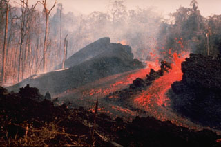 An E-flank fissure located 5 km from the summit produced an incandescent lava flow during 10-14 May 1978 that traveled 6 km to the Pandi River. Explosive activity took place from the summit crater of Ulawun over 7-13 May, accompanied by pyroclastic flows from a fissure high on the SE flank on 9 May. At least a dozen vents were active during this eruption.
Photo by K. Spellmeyer, 1978 (courtesy of Wally Johnson, Australia Bureau of Mineral Resources).
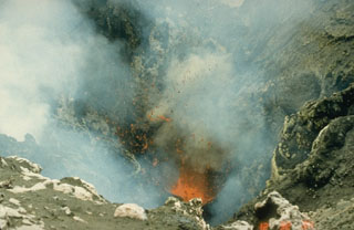 Incandescent spatter is ejected from a vent in the summit crater of Yasur volcano on 8 September 1988. The volcano has produced continuous Strombolian or Vulcanian activity since at least 1774. The mild activity seen here is occasionally interrupted by more violent explosive activity, such as during 1878, 1968, 1972, 1974-75, and 1977.
Photo by Ian Nairn, 1988 (New Zealand Geological Survey).
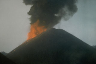 Incandescent ejecta and an ash plume from Strombolian eruptions that began in April 1991 are seen in this 16 May 1991 view of the scoria cone in the center of Barren Island. The 1991 eruption was the first from Barren Island in the 20th century.
Photo courtesy V.K. Raina, 1991 (Geological Survey of India)
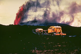 A bulldozer works to create a barrier to lava flows threatening areas below the village of Kapoho, on the lower East Rift Zone of Kīlauea, in January 1960. Lava fountains tower in the background from the eruptive vent, which was less than 1 km from the center of the village. Lava flows eventually engulfed the entire village, but the 5 km of walls that were constructed may have helped prevent the flows from reaching houses and a lighthouse at the coast.
Photo by Hawaii Volcanoes National Park, 1960.
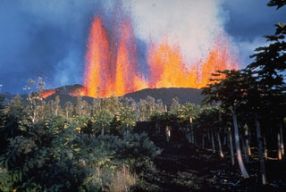 A line of lava fountains rises above a fissure on the lower East Rift Zone of Kīlauea in January 1960. The eruption originated near the village of Kapoho, which was overrun by lava flows. Lava flows traveled to the coast, reaching the ocean along a broad front.
Photo by Hawaii Volcanoes National Park, 1960.
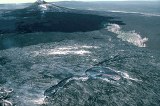 This 13 January 1987 view from the east shows the principal vents of the current eruption on Kīlauea's East Rift Zone, taken four years after the start of the eruption. The Pu‘u ‘Ō‘ō scoria cone to the left formed during the early stages of the eruption. Kūpaianaha to the lower right contains an actively convecting lava lake in this photo. The linear extension in the center foreground is at the head of a lava tube system, which insulated lava flows that reached the coast.
Photo by J. D. Griggs, 1987 (U.S. Geological Survey).
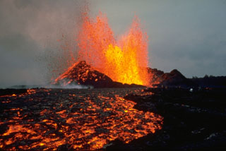 Lava fountains on 30 September 1977 produced lava flows from the Puʻu Kiai vent at Kīlauea. The eruption began along the East Rift Zone near Kalalau Crater on 13 September. The eruption ended on 1 October after producing lava flows that traveled 10 km SE to within 1 km of the coastal town of Kalapana.
Photo by Peter Lipman, 1977 (U.S. Geological Survey).
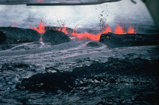 A 19-hour eruption of Kīlauea began on 30 April 1982, from fissures east of Halema’uma’u crater. This view from the north shows lava spatter feeding a lava flow two hours after the start of the eruption. Spatter ramparts of the 1964 eruption are partly buried by 1982 spatter.
Photo by Jack Lockwood, 1982 (U.S. Geological Survey).
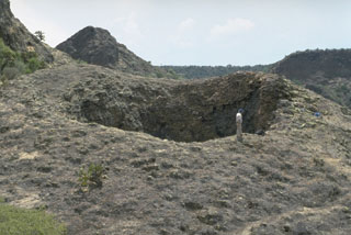 The La Boca crater is a product of the final eruptions of the La Breña-El Jagüey maar complex. La Boca and a nearby small crater, La Boquita, were formed by the accumulation of spatter that welded together during Strombolian activity. The two small craters originated from vents at the SE end of one of the post-maar cones constructed within La Breña maar after the magma-water interaction phase.
Photo by Jim Luhr, 1988 (Smithsonian Institution).
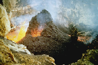 Spatter cones form when blobs of molten lava that are ejected from a vent solidify to form a steep-sided cone. This small spatter cone formed in MacKenney crater of Pacaya volcano in Guatemala on 10 February 1985, during an ongoing eruption that began in 1965. At the time of this photo, the spatter cone was 6-m high, ejecting incandescent volcanic bombs from its vent and extruding lava from its eastern (left) side.
Photo by Alfredo MacKenney, 1985.
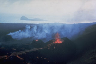 Lava flows issue from three small spatter cones on the island of Surtsey on 27 August 1966. Eruptions began in November 1963 and soon formed a new island, with lava effusion starting in April 1964. Eruptions at Iceland's newest island continued until 1967. The small island of Jolnir in the background began growing 800 m SW at the end of October 1965. It went through repeated episodes of growth and destruction before it ceased activity on 10 August 1966 and was eroded away by October.
Photo by Richie Williams, 1966 (U.S. Geological Survey).
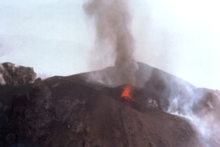 Two vents in the Fuego summit crater were active simultaneously at the time of this 24 February 1978 aerial photograph. A small ash plume rises above the vent at the far side of the crater, while the vent in the foreground ejects lava spatter. This vent feeds a degassing and faintly incandescent lava flow that can be seen to the lower right.
Photo by Bill Rose, 1978 (Michigan Technological University).
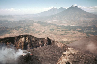 The Pacaya MacKenney crater contains spatter cones that have produced lava flows, and gas plumes like the one seen here. This photo taken in May 1981 shows the broad several-hundred-meter wide crater rim. From 9 May to 2 June lava flows from the spatter cones covered the crater floor and flowed through notch in the NW crater rim. In the background are Fuego and Acatenango (right-center) and Volcán de Agua (right).
Photo by Bill Rose, 1981 (Michigan Technological University).
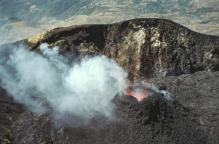 Incandescent lava spatter is ejected from a small cone in MacKenney crater in February 1981. Lava flows from the cone filled the crater floor and flowed out through a notch in the crater rim.
Photo by Bill Rose, 1981 (Michigan Technological University).
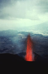 Incandescent lava rises from MacKenney crater early in the 1965-89 Pacaya eruption. The date of the photo is not certain but may have been around 1967. This view looks west from the summit of MacKenney cone with the flank of Volcán de Agua in the distance.
Photo by Alfredo MacKenney (courtesy of Bill Rose, Michigan Technological University).
 Strombolian eruptions at a spatter cone in Pacaya’s MacKenney crater. Lava flows through a notch in the crater and descends the northern flank. The date of the photo is uncertain, but may have been around 1967.
Photo by Alfredo MacKenney (courtesy of Bill Rose, Michigan Technological University).
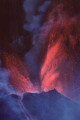 Vigorous lava fountaining occurred during a major eruptive episode the afternoon of 16 January 2000, initially reaching heights of 800 m then diminishing to 300 m. Fallout from the fountains fed near-constant avalanches and lava flows that traveled to the SW and N. Typical Strombolian activity resumed around 2030 that day. More or less continuous activity had resumed at Pacaya in January 1990 after 9-month-long quiescence.
Photo by Gene West, 2000.
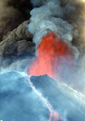 A lava fountain and ash plumes erupt above MacKenney crater at Pacaya during a major eruptive episode on 16 January 2000. A lava flow is also descending the northern flank of the cone. After a quiescent period of nine months, eruptive activity had been more or less continuous at Pacaya since January 1990. Activity has consisted of frequent moderate eruptions that constructed the summit cone, punctuated by occasional larger explosions such as this one that enlarge the crater and reduce the height of the cone.
Photo by Gene West, 2000.
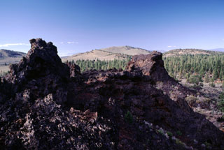 The Blowouts, the spatter vents in the foreground, are the source vents of the voluminous Devils Garden lava field. Devils Garden is the NW-most of a group of three lava fields SE of Newberry volcano and contains 117 km2 of overlapping pāhoehoe lava flows erupted from fissure vents at the NE part of the field. The extremely fluid and inflated pāhoehoe lavas typically left flows that increase from about a half meter thickness near the vent to about 5 m in the distal portion. The lava flows are either late Pleistocene or early Holocene in age.
Photo by Lee Siebert, 2000 (Smithsonian Institution).
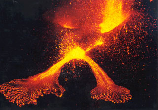 Two vents and lava flows inside Etna’s Voragine crater within the Central Crater are seen in July 1998. Explosions on 17 June and 12 July 1994 were the first sign of explosive activity since the end of the 1991-93 eruption. Intermittent eruptions from the Central Crater, Northeast Crater, and Southeast Crater continued into 2001. Paroxysmal eruptions on 23 December 1995 produced lava fountains as high as 500-600 m, and an eruption column that rose 6.2 km above the summit.
Photo by Jean-Claude Tanguy, 1998 (University of Paris).
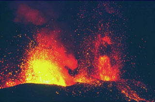 An eruption at Etna on 30 October 2002 shows incandescent lava fountains and associated spatter. The photo was taken from Mt. Ponte di Ferro looking E. This was part of an eruption that began on 26 October. Lava fountaining began on 27 October from fissure vents on the N and S flanks.
Photo by Jean-Claude Tanguy, 2002 (University of Paris).


