
The Servicio Nacional de Geología y Minería (SERNAGEOMIN) reported that at 1605 on 11 January a long-period (LP) earthquake at Villarrica was accompanied by a gas-and-ash plume that rose 200 m above the vent and drifted S. The Volcanic Alert Level remained at Green (the lowest level on a four-level scale).
Source: Servicio Nacional de Geología y Minería (SERNAGEOMIN)
Strombolian activity, gas-and-ash emissions, and crater incandescence during April-September 2023
Villarrica, in central Chile, consists of a 2-km-wide caldera that formed about 3,500 years ago and is located at the base of the presently active cone at the NW margin of a 6-km-wide caldera. Historical eruptions eruptions date back to 1558 and have been characterized by mild-to-moderate explosive activity with occasional lava effusions. The current eruption period began in December 2014 and has recently consisted of nighttime crater incandescence, ash emissions, and seismicity (BGVN 48:04). This report covers activity during April through September 2023 and describes occasional Strombolian activity, gas-and-ash emissions, and nighttime crater incandescence. Information for this report primarily comes from the Southern Andes Volcano Observatory (Observatorio Volcanológico de Los Andes del Sur, OVDAS), part of Chile's National Service of Geology and Mining (Servicio Nacional de Geología y Minería, SERNAGEOMIN) and satellite data.
Seismicity during April consisted of long period (LP) events and tremor (TRE); a total of 9,413 LP-type events and 759 TR-type events were detected throughout the month. Nighttime crater incandescence persisted and was visible in the degassing column. Sulfur dioxide data was obtained using Differential Absorption Optical Spectroscopy Equipment (DOAS) that showed an average value of 1,450 ± 198 tons per day (t/d) during 1-15 April and 1,129 ± 201 t/d during 16-30 April, with a maximum daily value of 2,784 t/d on 9 April. Gas-and-steam emissions of variable intensities rose above the active crater as high as 1.3 km above the crater on 13 April. Strombolian explosions were not observed and there was a slight decrease in the lava lake level.
There were 14,123 LP-type events and 727 TR-type events detected during May. According to sulfur dioxide measurements taken with DOAS equipment, the active crater emitted an average value of 1,826 ± 482 t/d during 1-15 May and 912 ± 41 t/d during 16-30 May, with a daily maximum value of 5,155 t/d on 13 May. Surveillance cameras showed continuous white gas-and-steam emissions that rose as high as 430 m above the crater on 27 May. Nighttime incandescence illuminated the gas column less than 300 m above the crater rim was and no pyroclastic emissions were reported. A landslide was identified on 13 May on the E flank of the volcano 50 m from the crater rim and extending 300 m away; SERNAGEOMIN noted that this event may have occurred on 12 May. During the morning of 27 and 28 May minor Strombolian explosions characterized by incandescent ejecta were recorded at the crater rim; the last reported Strombolian explosions had occurred at the end of March.
Seismic activity during June consisted of five volcano-tectonic (VT)-type events, 21,606 LP-type events, and 2,085 TR-type events. The average value of sulfur dioxide flux obtained by DOAS equipment was 1,420 ± 217 t/d during 1-15 June and 2,562 ± 804 t/d, with a maximum daily value of 4,810 t/d on 17 June. White gas-and-steam emissions rose less than 480 m above the crater; frequent nighttime crater incandescence was reflected in the degassing plume. On 12 June an emission rose 100 m above the crater and drifted NNW. On 15 June one or several emissions resulted in ashfall to the NE as far as 5.5 km from the crater, based on a Skysat satellite image. Several Strombolian explosions occurred within the crater; activity on 15 June was higher energy and ejected blocks 200-300 m on the NE slope. Surveillance cameras showed white gas-and-steam emissions rising 480 m above the crater on 16 June. On 19 and 24 June low-intensity Strombolian activity was observed, ejecting material as far as 200 m from the center of the crater to the E.
During July, seismicity included 29,319 LP-type events, 3,736 TR-type events, and two VT-type events. DOAS equipment recorded two days of sulfur dioxide emissions of 4,220 t/d and 1,009 t/d on 1 and 13 July, respectively. Constant nighttime incandescence was also recorded and was particularly noticeable when accompanied by eruptive columns on 12 and 16 July. Minor explosive events were detected in the crater. According to Skysat satellite images taken on 12, 13, and 16 July, ashfall deposits were identified 155 m S of the crater. According to POVI, incandescence was visible from two vents on the crater floor around 0336 on 12 July. Gas-and-ash emissions rose as high as 1.2 km above the crater on 13 July and drifted E and NW. A series of gas-and-steam pulses containing some ash deposited material on the upper E flank around 1551 on 13 July. During 16-31 July, average sulfur dioxide emissions of 1,679 ± 406 t/d were recorded, with a maximum daily value of 2,343 t/d on 28 July. Fine ash emissions were also reported on 16, 17, and 23 July.
Seismicity persisted during August, characterized by 27,011 LP-type events, 3,323 TR-type events, and three VT-type events. The average value of sulfur dioxide measurements taken during 1-15 August was 1,642 ± 270 t/d and 2,207 ± 4,549 t/d during 16-31 August, with a maximum daily value of 3,294 t/d on 27 August. Nighttime crater incandescence remained visible in degassing columns. White gas-and-steam emissions rose 480 m above the crater on 6 August. According to a Skysat satellite image from 6 August, ash accumulation was observed proximal to the crater and was mainly distributed toward the E slope. White gas-and-steam emissions rose 320 m above the crater on 26 August. Nighttime incandescence and Strombolian activity that generated ash emissions were reported on 27 August.
Seismicity during September was characterized by five VT-type events, 12,057 LP-type events, and 2,058 TR-type events. Nighttime incandescence persisted. On 2 September an ash emission rose 180 m above the crater and drifted SE at 1643 (figure 125) and a white gas-and-steam plume rose 320 m above the crater. According to the Buenos Aires VAAC, periods of continuous gas-and-ash emissions were visible in webcam images from 1830 on 2 September to 0110 on 3 September. Strombolian activity was observed on 2 September and during the early morning of 3 September, the latter event of which generated an ash emission that rose 60 m above the crater and drifted 100 m from the center of the crater to the NE and SW. Ashfall was reported to the SE and S as far as 750 m from the crater. The lava lake was active during 3-4 September and lava fountaining was visible for the first time since 26 March 2023, according to POVI. Fountains captured in webcam images at 2133 on 3 September and at 0054 on 4 September rose as high as 60 m above the crater rim and ejected material onto the upper W flank. Sulfur dioxide flux of 1,730 t/d and 1,281 t/d was measured on 3 and 4 September, respectively, according to data obtained by DOAS equipment.
 |
Figure 125. Webcam image of a gray ash emission rising above Villarrica on 2 September 2023 at 1643 (local time) that rose 180 m above the crater and drifted SE. Courtesy of SERNAGEOMIN (Reporte Especial de Actividad Volcanica (REAV), Region De La Araucania y Los Rios, Volcan Villarrica, 02 de septiembre de 2023, 17:05 Hora local). |
Strong Strombolian activity and larger gas-and-ash plumes were reported during 18-20 September. On 18 September activity was also associated with energetic LP-type events and notable sulfur dioxide fluxes (as high as 4,277 t/d). On 19 September Strombolian activity and incandescence were observed. On 20 September at 0914 ash emissions rose 50 m above the crater and drifted SSE, accompanied by Strombolian activity that ejected material less than 100 m SSE, causing fall deposits on that respective flank. SERNAGEOMIN reported that a Planet Scope satellite image taken on 20 September showed the lava lake in the crater, measuring 32 m x 35 m and an area of 0.001 km2. Several ash emissions were recorded at 0841, 0910, 1251, 1306, 1312, 1315, and 1324 on 23 September and rose less than 150 m above the crater. The sulfur dioxide flux value was 698 t/d on 23 September and 1,097 t/d on 24 September. On 24 September the Volcanic Alert Level (VAL) was raised to Orange (the third level on a four-color scale). SENAPRED maintained the Alert Level at Yellow (the middle level on a three-color scale) for the communities of Villarrica, Pucón (16 km N), Curarrehue, and Panguipulli.
During 24-25 September there was an increase in seismic energy (observed at TR-events) and acoustic signals, characterized by 1 VT-type event, 213 LP-type events, and 124 TR-type events. Mainly white gas-and-steam emissions, in addition to occasional fine ash emissions were recorded. During the early morning of 25 September Strombolian explosions were reported and ejected material 250 m in all directions, though dominantly toward the NW. On 25 September the average value of sulfur dioxide flux was 760 t/d. Seismicity during 25-30 September consisted of five VT-type events, 1,937 LP-type events, and 456 TR-type events.
During 25-29 September moderate Strombolian activity was observed and ejected material as far as the crater rim. In addition, ash pulses lasting roughly 50 minutes were observed around 0700 and dispersed ENE. During 26-27 September a TR episode lasted 6.5 hours and was accompanied by discrete acoustic signals. Satellite images from 26 September showed a spatter cone on the crater floor with one vent that measured 10 x 14 m and a smaller vent about 35 m NE of the cone. SERNAGEOMIN reported an abundant number of bomb-sized blocks up to 150 m from the crater, as well as impact marks on the snow, which indicated explosive activity. A low-altitude ash emission was observed drifting NW around 1140 on 28 September, based on webcam images. Between 0620 and 0850 on 29 September an ash emission rose 60 m above the crater and drifted NW. During an overflight taken around 1000 on 29 September scientists observed molten material in the vent, a large accumulation of pyroclasts inside the crater, and energetic degassing, some of which contained a small amount of ash. Block-sized pyroclasts were deposited on the internal walls and near the crater, and a distal ash deposit was also visible. The average sulfur dioxide flux measured on 28 September was 344 t/d. Satellite images taken on 29 September ashfall was deposited roughly 3 km WNW from the crater and nighttime crater incandescence remained visible. The average sulfur dioxide flux value from 29 September was 199 t/d. On 30 September at 0740 a pulsating ash emission rose 1.1 km above the crater and drifted NNW (figure 126). Deposits on the S flank extended as far as 4.5 km from the crater rim, based on satellite images from 30 September.
 |
Figure 126. Webcam image of a gray ash plume rising 1.1 km above the crater of Villarrica at 0740 (local time) on 30 September 2023. Courtesy of SERNAGEOMIN (Reporte Especial de Actividad Volcanica (REAV), Region De La Araucania y Los Rios, Volcan Villarrica, 30 de septiembre de 2023, 09:30 Hora local). |
Infrared MODIS satellite data processed by MIROVA (Middle InfraRed Observation of Volcanic Activity) showed intermittent thermal activity during April through September, with slightly stronger activity detected during late September (figure 127). Small clusters of thermal activity were detected during mid-June, early July, early August, and late September. According to the MODVOLC thermal alert system, a total of four thermal hotspots were detected on 7 July and 3 and 23 September. This activity was also intermittently captured in infrared satellite imagery on clear weather days (figure 128).
 |
Figure 127. Low-to-moderate power thermal anomalies were detected at Villarrica during April through September 2023, according to this MIROVA graph (Log Radiative Power). Activity was relatively low during April through mid-June. Small clusters of activity occurred during mid-June, early July, early August, and late September. Courtesy of MIROVA. |
 |
Figure 128. Consistent bright thermal anomalies (bright yellow-orange) were visible at the summit crater of Villarrica in infrared (bands B12, B11, B4) satellite images, as shown on 17 June 2023 (top left), 17 July 2023 (top right), 6 August 2023 (bottom left), and 20 September 2023 (bottom right). Courtesy of Copernicus Browser. |
Information Contacts: Servicio Nacional de Geología y Minería (SERNAGEOMIN), Observatorio Volcanológico de Los Andes del Sur (OVDAS), Avda Sta María No. 0104, Santiago, Chile (URL: http://www.sernageomin.cl/); Proyecto Observación Villarrica Internet (POVI) (URL: http://www.povi.cl/); Sistema y Servicio Nacional de Prevención y Repuesta Ante Desastres (SENAPRED), Av. Beauchef 1671, Santiago, Chile (URL: https://web.senapred.cl/); Buenos Aires Volcanic Ash Advisory Center (VAAC), Servicio Meteorológico Nacional-Fuerza Aérea Argentina, 25 de mayo 658, Buenos Aires, Argentina (URL: http://www.smn.gov.ar/vaac/buenosaires/inicio.php); MIROVA (Middle InfraRed Observation of Volcanic Activity), a collaborative project between the Universities of Turin and Florence (Italy) supported by the Centre for Volcanic Risk of the Italian Civil Protection Department (URL: http://www.mirovaweb.it/); Hawai'i Institute of Geophysics and Planetology (HIGP) - MODVOLC Thermal Alerts System, School of Ocean and Earth Science and Technology (SOEST), Univ. of Hawai'i, 2525 Correa Road, Honolulu, HI 96822, USA (URL: http://modis.higp.hawaii.edu/); Copernicus Browser, Copernicus Data Space Ecosystem, European Space Agency (URL: https://dataspace.copernicus.eu/browser/).
2025: January
2024: January
| February
| May
| June
| July
| August
| October
2023: January
| February
| March
| July
| August
| September
| October
| November
| December
2022: February
| September
| October
| November
| December
2021: February
| April
| November
2020: January
| July
| August
| September
| October
| November
| December
2019: March
| April
| May
| June
| July
| August
| September
2018: March
| July
2017: September
| November
| December
2016: March
| April
2015: February
| March
| April
| May
| June
2014: December
2013: July
2012: March
| April
| November
2011: February
| June
| September
2010: March
| April
| May
| September
| October
2008: October
2005: March
| April
2002: April
| October
2001: August
The Servicio Nacional de Geología y Minería (SERNAGEOMIN) reported that at 1605 on 11 January a long-period (LP) earthquake at Villarrica was accompanied by a gas-and-ash plume that rose 200 m above the vent and drifted S. The Volcanic Alert Level remained at Green (the lowest level on a four-level scale).
Source: Servicio Nacional de Geología y Minería (SERNAGEOMIN)
The Servicio Nacional de Geología y Minería (SERNAGEOMIN) reported that a couple of small explosions at Villarrica were recorded on 7 January. Webcam images showed white and gray plumes rising from the crater. The Volcanic Alert Level remained at Green (the lowest level on a four-level scale).
Source: Servicio Nacional de Geología y Minería (SERNAGEOMIN)
On 11 October Servicio Nacional de Geología y Minería (SERNAGEOMIN) reported that low levels of activity were detected at Villarrica during 16-30 September, characterized as a decrease in the frequency of explosions with ejection of high-temperature tephra outside the crater. A webcam located near the volcano recorded only gas-and-steam emissions rising to low heights, up to a maximum of 120 m above the crater rim, though weather clouds often prevented observations. Seismicity was low. Sulfur dioxide emissions averaged 525 ± 93 tonnes per day (t/d), with a maximum daily average of 618 t/d recorded on 26 September; these values were at baseline levels. The Volcanic Alert Level was lowered to Green (the lowest level on a four-level scale). SENAPRED decreased the restricted zone around the crater to 500 m, with a “Preventative Early Warning“ status issued for the communities of Villarrica, Pucón (16 km N), Curarrehue, and Panguipulli.
Sources: Servicio Nacional de Geología y Minería (SERNAGEOMIN); Sistema y Servicio Nacional de Prevención y Repuesta Ante Desastres (SENAPRED)
Servicio Nacional de Geología y Minería (SERNAGEOMIN) and Nacional de Prevención y Repuesta Ante Desastres (SENAPRED) reduced the exclusion zone around Villarrica to 1 km on 23 August. The announcement noted that there had been a decrease in the number of explosions that ejected material above the crater rim and that monitoring data had showed low levels of activity for the previous few months. The Volcanic Alert Level remained at Yellow (the second lowest level on a four-level scale) and SENAPRED maintained the Alert Level at Yellow (the middle level on a three-color scale) for the communities of Villarrica, Pucón (16 km N), Curarrehue, and Panguipulli.
Sources: Servicio Nacional de Geología y Minería (SERNAGEOMIN); Sistema y Servicio Nacional de Prevención y Repuesta Ante Desastres (SENAPRED)
Servicio Nacional de Geología y Minería (SERNAGEOMIN) reported that an explosion at Villarrica ejected incandescent material around 190 m above the crater rim on 24 July. Some of the incandescent material landed on the flanks and rolled short distances based on the webcam view posted with the report. According to POVI a series of phreatomagmatic pulses on 29 July produced ash plumes and ashfall on the upper E flank. The Volcanic Alert level remained at Yellow (the third level on a four-level scale) and the public was warned to stay 1.5 km away from the crater. SENAPRED maintained the Alert Level at Yellow (the middle level on a three-color scale) for the communities of Villarrica, Pucón (16 km N), Curarrehue, and Panguipulli.
Sources: Servicio Nacional de Geología y Minería (SERNAGEOMIN); Sistema y Servicio Nacional de Prevención y Repuesta Ante Desastres (SENAPRED); Proyecto Observación Villarrica Internet (POVI)
After field observations and analysis of data, Servicio Nacional de Geología y Minería (SERNAGEOMIN) reduced the exclusion zone around Villarrica to 1.5 km on 19 July. SENAPRED maintained the Alert Level at Yellow (the middle level on a three-color scale) for the communities of Villarrica, Pucón (16 km N), Curarrehue, and Panguipulli. Two ash emissions were recorded at 1346 and 1349 on 21 July and drifted NE. The second ash plume rose 320 m above the crater rim and was associated with a long-period earthquake. Another ash emission event at 1438 was also associated with a long-period earthquake; the plume rose 780 m above the crater rim and drifted NE.
Sources: Servicio Nacional de Geología y Minería (SERNAGEOMIN); Sistema y Servicio Nacional de Prevención y Repuesta Ante Desastres (SENAPRED)
Servicio Nacional de Geología y Minería (SERNAGEOMIN) reported that an energetic explosion, more significant than the usual Strombolian events at Villarrica, ejected ballistics up to 500 m above the crater rim and as far as 1,400 m along the WNW flank (near the head of Correntoso valley) at 2104 on 10 July. The explosion also generated a column of ash and gas that reached over 600 m above the crater rim and was accompanied by a long-period (LP) earthquake. Following the explosion, the seismic energy levels remained low. However, infrasound observations suggest recurrent lava lake activity, with temporal variations in the level of activity. The volcano is currently exhibiting a heightened level of activity that exceeds its usual baseline. This includes signs of energetic instability that surpass the typical Strombolian activity usually recorded, with no precursory activity. The hazard zone radius was expanded from 500 to 2,000 m from the center of the crater as of 1130 on 12 July.
Sources: Servicio Nacional de Geología y Minería (SERNAGEOMIN); Servicio Geológico Minero Argentino (SEGEMAR)
SERNAGEOMIN reported that at 0428 on 25 June an explosion at Villarrica ejected incandescent material onto the upper flanks. According to POVI a series of phreatomagmatic pulses on 29 June produced an ash plume that drifted E and deposited ash on the E flank. The Volcanic Alert Level remained at Yellow (the second lowest level on a four-level scale) and the public was warned to stay 500 m away from the active crater.
Sources: Servicio Nacional de Geología y Minería (SERNAGEOMIN); Proyecto Observación Villarrica Internet (POVI)
SERNAGEOMIN reported that activity at Villarrica was observed in webcam images on 24 June. The images showed a few pulses of incandescence above the crater rim and plumes rising from the crater. At 0428 on 25 June an explosion ejected incandescent material above the crater rim and produced a gas plume that rose about 700 m above the crater rim and drifted W. The Volcanic Alert Level remained at Yellow (the second lowest level on a four-level scale) and the public was warned to stay 500 m away from the active crater.
Source: Servicio Nacional de Geología y Minería (SERNAGEOMIN)
SERNAGEOMIN reported that the eruption at Villarrica continued. A volcano-tectonic evet was recorded by the seismic network at 0428 on 18 May. At 0911 on that same day a gas-and-ash plume rose 340 m above the crater rim and drifted ESE. The Volcanic Alert Level remained at Yellow (the second lowest level on a four-level scale) and the public was warned to stay 500 m away from the active crater.
Source: Servicio Nacional de Geología y Minería (SERNAGEOMIN)
SERNAGEOMIN reported that the eruption at Villarrica continued during 29 February-5 March. At 1759 on 3 March a gas-and-ash plume rose 400 m above the crater rim and drifted NE. The Volcanic Alert Level remained at Yellow (the second lowest level on a four-level scale) and the public was warned to stay 1 km away from the active crater.
Source: Servicio Nacional de Geología y Minería (SERNAGEOMIN)
SERNAGEOMIN reported that the eruption at Villarrica continued during 12-20 February. At 1937 on 12 February a long-period (LP) earthquake associated with fluid movement was accompanied by a gas emission with minor ash content that rose 420 m above the vent and drifted SW. LP earthquakes at 2206 on 13 February and 0153 on 14 February were accompanied by Strombolian explosions that ejected material 40-60 m high. The ejected material fell back into the crater. LP events were recorded at 0740 on 15 February and 0228 on 17 February, though no emissions were visible on the 15th and weather conditions prevented visual observations on the 17th. The Volcanic Alert level remained at Yellow (the second lowest level on a four-level scale) and the public was warned to stay 1 km away from the active crater.
Source: Servicio Nacional de Geología y Minería (SERNAGEOMIN)
POVI reported that Strombolian activity at Villarrica was visible on 22 January in webcam images from a new camera located W of the volcano. Incandescent material was ejected above the crater rim. The Volcanic Alert level remained at Yellow (the third level on a four-level scale) according to SERNAGEOMIN.
Sources: Servicio Nacional de Geología y Minería (SERNAGEOMIN); Proyecto Observación Villarrica Internet (POVI)
POVI reported that vigorous Strombolian activity at Villarrica was visible overnight during 2-3 December. Incandescent material was ejected as high as 85 m above the crater rim. SERNAGEOMIN reported that at 2030 on 9 December a long-period (LP) earthquake associated with fluid movement was accompanied by an emission that rose 120 m above the vent and drifted ENE. The Volcanic Alert level remained at Yellow (the third level on a four-level scale) according to SERNAGEOMIN.
Sources: Servicio Nacional de Geología y Minería (SERNAGEOMIN); Proyecto Observación Villarrica Internet (POVI)
Explosive activity at Villarrica continued during 8-14 November, according to POVI. Webcam images from 0215 on 8 November showed bright crater incandescence, and at 2314 on 12 November and 0109 on 13 November webcam images showed low-level Strombolian type explosive activity at the summit. The Volcanic Alert level remained at Yellow (the third level on a four-level scale) according to SERNAGEOMIN.
Sources: Servicio Nacional de Geología y Minería (SERNAGEOMIN); Proyecto Observación Villarrica Internet (POVI)
According to the Buenos Aires VAAC a diffuse ash-and-gas plume from Villarrica was observed in satellite and webcam images at 0900 on 2 November rising to 3.7 km (12,000 ft) a.s.l. and dissipating near the summit. POVI reported that lava fountaining above the crater rim was visible in webcam images for more than 15 seconds on 3 November. Incandescence from the summit was visible during the early morning hours of 6 November. The Volcanic Alert level remained at Yellow (the third level on a four-level scale) according to SERNAGEOMIN and the public was warned to stay 2 km away from the crater. SENAPRED maintained the Alert Level at Yellow (the middle level on a three-color scale) for the communities of Villarrica, Pucón (16 km N), Curarrehue, and Panguipulli.
Sources: Servicio Nacional de Geología y Minería (SERNAGEOMIN); Sistema y Servicio Nacional de Prevención y Repuesta Ante Desastres (SENAPRED); Buenos Aires Volcanic Ash Advisory Center (VAAC); Proyecto Observación Villarrica Internet (POVI)
SERNAGEOMIN reported that at 0700 on 31 October an ash-and-gas plume rose 260 m above Villarrica’s crater rim. The Volcanic Alert level remained at Yellow (the third level on a four-level scale) according to SERNAGEOMIN and the public was warned to stay 2 km away from the crater. SENAPRED maintained the Alert Level at Yellow (the middle level on a three-color scale) for the communities of Villarrica, Pucón (16 km N), Curarrehue, and Panguipulli.
Sources: Servicio Nacional de Geología y Minería (SERNAGEOMIN); Sistema y Servicio Nacional de Prevención y Repuesta Ante Desastres (SENAPRED)
POVI reported that Strombolian activity and crater incandescence at Villarrica was observed in webcam images during 22-23 October, coinciding with the highest thermal radiance identified in Sentinel satellite data since July 2018. The Volcanic Alert level remained at Yellow (the third level on a four-level scale) according to SERNAGEOMIN and the public was warned to stay 2 km away from the crater. SENAPRED maintained the Alert Level at Yellow (the middle level on a three-color scale) for the communities of Villarrica, Pucón (16 km N), Curarrehue, and Panguipulli.
Sources: Proyecto Observación Villarrica Internet (POVI); Servicio Nacional de Geología y Minería (SERNAGEOMIN); Sistema y Servicio Nacional de Prevención y Repuesta Ante Desastres (SENAPRED)
POVI reported that Strombolian activity at Villarrica continued to be observed in webcam images during 11-16 October. Lava fountains were observed during 11-12 October; incandescent material was ejected as high as 125 m above the crater rim and incandescent bombs were ejected onto the upper flanks. Strombolian explosions were less vigorous during 12-16 October with ballistics rising no higher than 100 m above the crater rim. Some incandescent material was ejected onto the upper N flank during 15-16 October. According to SERNAGEOMIN, the Alert Level remained at Yellow (the third level on a four-level scale) and the public was warned to stay 2 km away from the crater. SENAPRED maintained the Alert Level at Yellow (the middle level on a three-color scale) for the communities of Villarrica, Pucón (16 km N), Curarrehue, and Panguipulli.
Sources: Proyecto Observación Villarrica Internet (POVI); Servicio Nacional de Geología y Minería (SERNAGEOMIN); Sistema y Servicio Nacional de Prevención y Repuesta Ante Desastres (SENAPRED)
On 6 October SERNAGEOMIN lowered the Volcanic Alert Level for Villarrica to Yellow (the second level on a four-level scale), noting that activity had returned to moderate and more stable levels during the previous few days. The frequency and intensity of emissions had declined; gas emissions rose to low heights and sometimes contained small amounts of tephra. Nighttime crater incandescence was observed, and Strombolian explosions ejected material onto the upper flanks. The public was warned to stay at least 2 km away from the crater. SENAPRED maintained the Alert Level at Yellow (the middle level on a three-color scale) for the communities of Villarrica, Pucón (16 km N), Curarrehue, and Panguipulli.
Sources: Servicio Nacional de Geología y Minería (SERNAGEOMIN); Sistema y Servicio Nacional de Prevención y Repuesta Ante Desastres (SENAPRED)
SERNAGEOMIN reported that the eruption in Villarrica’s summit crater continued during 26 September-3 October. Strombolian activity was observed almost nightly and largely confined to the crater, though sometimes material was ejected beyond the crater onto the upper flanks; weather conditions sometimes prevented visual observations of the summit. Satellite images from 26 September showed a spatter cone on the crater floor with one vent measuring 10 x 14 m, and a smaller vent about 35 m NE of the cone. During 26-27 September there were deposits of bombs around the upper flanks within 150 of the crater rim and several impact craters on the snow from explosive activity. Discrete emissions with low ash content were visible. Steam-and-gas emissions were visible during 27-28 September and tephra was ejected onto the upper NW flank. Steam-and-gas emissions sometimes contained ash during 28-29 September; a period of continuous ash emissions recorded during 1020-1250 on 29 September rose 60 m above the crater rim and drifted NW.
During an overflight on 29 September scientists observed lava in the vent and deposits of blocks in the crater. A satellite image showed ash deposits on the WNW flank as far as 3 km from the crater. Material was ejected from the crater several times during 29-30 September, with the emissions varying in duration and tephra content; notably, at 0740 on 30 September a pulsating ash plume rose 1.1 km above the crater rim and drifted NNW. Deposits on the S flank extended as far as 4.5 km from the crater rim as seen in 30 September satellite images. Steam-and-gas emissions with no or low ash content rose to lower heights on 1 October. Incandescence lit up the bases of two gas plumes, rising from the two vents, on 2 October, and dense white gas plumes rose as high as 300 m on 3 October. The Volcanic Alert Level remained at Orange (the third level on a four-level scale) and the public was warned to stay 8 km away from the crater. SENAPRED maintained the Alert Level at Yellow (the middle level on a three-color scale) for the communities of Villarrica, Pucón (16 km N), Curarrehue, and Panguipulli.
Sources: Servicio Nacional de Geología y Minería (SERNAGEOMIN); Sistema y Servicio Nacional de Prevención y Repuesta Ante Desastres (SENAPRED)
SERNAGEOMIN reported that the eruption in Villarrica’s summit crater intensified during 20-26 September. A long-period (LP) earthquake associated with fluid movement, recorded by the seismic network at 0914 on 20 September, was accompanied by a short grayish-brown pyroclastic emission that rose 50 m above the crater rim and drifted SSE. Whitish gas emissions were visible before and after the event. Another LP event was recorded at 1012 on 21 September, but weather conditions prevented visual observations.
A sustained increase in seismicity was recorded throughout the day on 23 September. Several discrete, low-altitude ash emissions were visible rising to heights less than 150 m above the crater rim and drifting SE. Some notable emissions occurred at 0841, 0910, 1251, 1306, 1312, 1315, and 1324. Diffuse gas emissions were visible in webcam images. During 23-24 September RSAM values reached high levels, Strombolian explosions ejected material onto the upper flanks near the crater, and thermal anomalies intensified. On 24 September the Volcanic Alert Level was raised to Orange (the third level on a four-level scale) and the exclusion zone was increased to an 8-km radius. SENAPRED maintained the Alert Level at Yellow (the middle level on a three-color scale) for the communities of Villarrica, Pucón (16 km N), Curarrehue, and Panguipulli. During 24-26 September seismicity stabilized then decreased slightly, though it remained at high levels. During the early morning of 25 September Strombolian explosions ejected incandescent material up to 250 above the crater rim and onto the upper flanks, mainly to the NW. Strombolian explosions continued to be recorded on 26 September. A continuous ash emission drifted ENE for a period of 50 minutes. Thermal anomalies continued to be identified in satellite data.
Sources: Servicio Nacional de Geología y Minería (SERNAGEOMIN); Sistema y Servicio Nacional de Prevención y Repuesta Ante Desastres (SENAPRED)
SERNAGEOMIN reported that the eruption in Villarrica’s summit crater was ongoing during 13-19 September. Long-period (LP) earthquakes were recorded at 0622 on 15 September and at 0426 and 0723 on 16 September; weather conditions prevented views of the summit during these events. An LP earthquake at 0130 on 18 September was associated with crater incandescence and a gas-and-steam plume that rose 120 m above the crater rim. The Volcanic Alert level remained at Yellow (the second highest on a four-level scale) according to SERNAGEOMIN and the public was warned to stay 500 m away from the crater. SENAPRED maintained the Alert Level at Yellow (the middle level on a three-color scale) for the communities of Villarrica, Pucón (16 km N), Curarrehue, and Panguipulli.
Sources: Servicio Nacional de Geología y Minería (SERNAGEOMIN); Sistema y Servicio Nacional de Prevención y Repuesta Ante Desastres (SENAPRED)
SERNAGEOMIN reported that a long-period earthquake recorded at 1643 on 2 September was accompanied by a minor ash plume that rose to 180 m above Villarrica’s summit crater rim and dispersed SE. According to the Buenos Aires VAAC, periods of continuous gas-and-ash emissions were visible in webcam images from 1830 on 2 September to 0110 on 3 September. POVI reported that the lava lake was active and during 3-4 September lava fountaining was visible for the first time since 26 March. Fountains captures in webcam images at 2133 on 3 September and 0054 on 4 September rose as high as 60 m above the crater rim and ejected material onto the upper W flank. The Volcanic Alert level remained at Yellow (the second highest on a four-level scale) according to SERNAGEOMIN and the public was warned to stay 500 m away from the crater. SENAPRED maintained the Alert Level at Yellow (the middle level on a three-color scale) for the communities of Villarrica, Pucón (16 km N), Curarrehue, and Panguipulli.
Sources: Servicio Nacional de Geología y Minería (SERNAGEOMIN); Sistema y Servicio Nacional de Prevención y Repuesta Ante Desastres (SENAPRED); Proyecto Observación Villarrica Internet (POVI); Buenos Aires Volcanic Ash Advisory Center (VAAC)
POVI reported that incandescence from two vents on the floor of Villarrica’s summit crater was visible, reflected by gas-and-steam emissions, during the early morning (around 0336) of 12 July. At around 1551 on 13 July a series of gas-and-steam pulses that contained some ash that was deposited on the upper E flank. According to Corporación Ciudadana Red Nacional de Emergencia incandescence was also reflected by gas-and-steam plumes on 16 July. The Volcanic Alert level remained at Yellow (the second highest on a four-level scale) according to SERNAGEOMIN. SENAPRED maintained the Alert Level at Yellow (the middle level on a three-color scale) for the communities of Villarrica, Pucón (16 km N), Curarrehue, and Panguipulli, and SINAPRED maintained an exclusion zone of 500 m from the crater.
Sources: Proyecto Observación Villarrica Internet (POVI); Servicio Nacional de Geología y Minería (SERNAGEOMIN); Sistema y Servicio Nacional de Prevención y Repuesta Ante Desastres (SENAPRED); Corporación Ciudadana Red Nacional de Emergencia
The eruption at Villarrica was ongoing during 21-28 March. POVI reported that on 21 March Strombolian explosions ejected material 100 m above the crater rim. SERNAGEOMIN reported that at 0551 on 24 March a long-period earthquake was associated with low-intensity crater incandescence. According to POVI a cone with a vent that was about 13 m in diameter had formed on the crater floor and was visible during a recent overflight. Sometimes lava fountains rose over 100 m. At 2249 on 26 March Strombolian explosions ejected incandescent material more than 110 m above the crater rim. The Volcanic Alert level remained at Yellow (the second highest on a four-level scale) according to SERNAGEOMIN. SENAPRED maintained the Alert Level at Yellow (the middle level on a three-color scale) for the communities of Villarrica, Pucón (16 km N), Curarrehue, and Panguipulli, and SINAPRED maintained an exclusion zone of 1 km from the crater.
Sources: Servicio Nacional de Geología y Minería (SERNAGEOMIN); Proyecto Observación Villarrica Internet (POVI); Sistema y Servicio Nacional de Prevención y Repuesta Ante Desastres (SENAPRED)
Villarrica continued to erupt during 15-21 March. POVI posted a webcam image from 2227 on 18 March showing incandescent material from Strombolian explosions rising more than 100 m above the crater rim. Explosions were heard up to 8 km away. According to SERNAGEOMIN a long-period earthquake recorded at 1921 on 19 March was accompanied by a plume containing tephra that rose to 340 m above the crater rim and dispersed NE. A webcam image from a few hours later, at 2219, showed plumes rising from the crater and incandescence. The Volcanic Alert level remained at Yellow (the second highest on a four-level scale) according to SERNAGEOMIN. SENAPRED maintained the Alert Level at Yellow (the middle level on a three-color scale) for the communities of Villarrica, Pucón (16 km N), Curarrehue, and Panguipulli, and SINAPRED maintained an exclusion zone of 1 km from the crater.
Sources: Servicio Nacional de Geología y Minería (SERNAGEOMIN); Proyecto Observación Villarrica Internet (POVI); Sistema y Servicio Nacional de Prevención y Repuesta Ante Desastres (SENAPRED)
SERNAGEOMIN reported that the eruption at Villarrica was ongoing during 8-14 March. Webcam images on 13 March showed incandescence above the crater rim from Strombolian activity. The Alert Level remained at Yellow (the second lowest level on a four-color scale) according to SERNAGEOMIN. ONEMI maintained the Alert Level at Yellow (the middle level on a three-color scale) for the municipalities of Villarrica, Pucón (16 km N), Curarrehue, and the commune of Panguipulli.
Sources: Servicio Nacional de Geología y Minería (SERNAGEOMIN); Oficina Nacional de Emergencia-Ministerio del Interior (ONEMI)
The eruption at Villarrica was ongoing during 22-28 February. Low-intensity gas emissions rose from the crater on 22 February. Long-period earthquakes recorded at 1056 and 1301 on 27 February were associated with ash plumes that rose 300 m above the crater rim. Several additional minor ash emissions were visible during 1056-1320. The Alert Level remained at Yellow (the second lowest level on a four-color scale) according to SERNAGEOMIN. ONEMI maintained the Alert Level at Yellow (the middle level on a three-color scale) for the municipalities of Villarrica, Pucón (16 km N), Curarrehue, and the commune of Panguipulli.
Sources: Servicio Nacional de Geología y Minería (SERNAGEOMIN); Oficina Nacional de Emergencia-Ministerio del Interior (ONEMI)
The eruption at Villarrica was ongoing during 15-21 February. POVI reported that on 17 February Strombolian explosions ejected material 100 m above the crater rim and onto the upper SW flank. Webcam images on 20 February showed two separate fountains of incandescent material, suggesting that a second vent had opened to the E of the first vent. Spatter was ejected as high as 80 m above the crater rim and onto the upper NE flank. A sequence of Strombolian explosions were visible from 2030 on 20 February to 0630 on 21 February. Material was ejected as high as 80 m above the crater rim and onto the upper E flank. The Alert Level remained at Yellow (the second lowest level on a four-color scale) according to SERNAGEOMIN. ONEMI maintained the Alert Level at Yellow (the middle level on a three-color scale) for the municipalities of Villarrica, Pucón (16 km N), Curarrehue, and the commune of Panguipulli.
Sources: Servicio Nacional de Geología y Minería (SERNAGEOMIN); Oficina Nacional de Emergencia-Ministerio del Interior (ONEMI); Proyecto Observación Villarrica Internet (POVI)
The eruption at Villarrica was ongoing during 6-12 February. POVI reported that three explosions were heard during 1940-1942 on 6 February, and then hours later spatter was seen rising 30 m above the crater rim. On 9 February lava fountains were seen rising around 50 m above the crater rim. SERNAGEOMIN noted that in the early part of the week small Strombolian explosions and gas emissions were recorded and observed in webcam images. A period of increased seismicity was recorded on 12 February, after several weeks of stable levels. The seismicity and recent visual observations (especially ash emissions observed on 27 January) indicated that activity was localized at shallow levels, without a clear indication of deep magmatic contribution. The Alert Level remained at Yellow (the second lowest level on a four-color scale). ONEMI maintained the Alert Level at Yellow (the middle level on a three-color scale) for the municipalities of Villarrica, Pucón (16 km N), Curarrehue, and the commune of Panguipulli.
Sources: Oficina Nacional de Emergencia-Ministerio del Interior (ONEMI); Proyecto Observación Villarrica Internet (POVI); Servicio Nacional de Geología y Minería (SERNAGEOMIN)
SERNAGEOMIN reported that the eruption at Villarrica was ongoing during 17-24 January. Daily minor Strombolian explosions from a vent on the crater floor ejected incandescent material that generally rose as high as 100 m above the crater rim and fell back down in and around the crater. On 19 January POVI noted that lava was ejected as high as 140 m above the crater rim and onto the W and SW flanks. Explosion noises were heard on 19 and 22 January in areas within a radius of 10 km. The Alert Level remained at Yellow (the second lowest level on a four-color scale). ONEMI maintained the Alert Level at Yellow (the middle level on a three-color scale) for the municipalities of Villarrica, Pucón (16 km N), Curarrehue, and the commune of Panguipulli.
Sources: Servicio Nacional de Geología y Minería (SERNAGEOMIN); Oficina Nacional de Emergencia-Ministerio del Interior (ONEMI); Proyecto Observación Villarrica Internet (POVI)
SERNAGEOMIN reported that the eruption at Villarrica was ongoing during 11-17 January. Strombolian explosions and lava fountaining from the vent on the crater floor were frequently visible in webcam images. Explosions during 11-12 January ejected material 80 m high and as far as 250 m onto the NE flank. The number of explosions increased during 14-15 January, some ejecting material up to 150 m above the crater rim. POVI scientists counted about 70 instances of lava fountaining from 2130 on 14 January to 0600 on 15 January. Material ejected by the explosions stayed within or near the crater during 16-17 January. The Alert Level remained at Yellow (the second lowest level on a four-color scale). ONEMI maintained the Alert Level at Yellow (the middle level on a three-color scale) for the municipalities of Villarrica, Pucón (16 km N), Curarrehue, and the commune of Panguipulli.
Sources: Servicio Nacional de Geología y Minería (SERNAGEOMIN); Oficina Nacional de Emergencia-Ministerio del Interior (ONEMI); Proyecto Observación Villarrica Internet (POVI)
SERNAGEOMIN reported that activity at Villarrica had increased in recent weeks, with explosions ejecting material almost as far as 480 m, near the extent of the 500 m exclusion zone in place around the crater. On 6 January the exclusion zone was increased to 1 km as a preventative measure. The Alert Level remained at Yellow (the second lowest level on a four-color scale). ONEMI maintained the Alert Level at Yellow (the middle level on a three-color scale) for the municipalities of Villarrica, Pucón (16 km N), Curarrehue, and the commune of Panguipulli.
Sources: Servicio Nacional de Geología y Minería (SERNAGEOMIN); Oficina Nacional de Emergencia-Ministerio del Interior (ONEMI)
POVI counted 21 Strombolian events that ejected incandescent material onto Villarrica’s upper SW flank from 2200 on 28 December to 0540 on 29 December. More than 100 Strombolian events ejected incandescent material onto the upper W and NW flanks during 30-31 December. Observatorio Argentino de Vigilancia Volcánica (OAVV) reported that an explosion at 2356 on 31 December ejected incandescent material onto the upper NW flank as far as 480 m from the crater rim, and an explosion at 0219 on 31 December ejected incandescent material onto the same flank as far as 150 m. Both explosions ejected incandescent material as high as 120 m above the crater rim. SERNAGEOMIN reported that at 1307 on 1 January a long-period earthquake was recorded but weather clouds prevented visual confirmation of possible emissions. The Alert Level remained at Yellow (the second lowest level on a four-color scale) and the public was warned that material could be ejected within 500 m of the crater. ONEMI maintained the Alert Level at Yellow (the middle level on a three-color scale) for the municipalities of Villarrica, Pucón (16 km N), Curarrehue, and the commune of Panguipulli.
Sources: Servicio Geológico Minero Argentino (SEGEMAR); Servicio Nacional de Geología y Minería (SERNAGEOMIN); Oficina Nacional de Emergencia-Ministerio del Interior (ONEMI); Proyecto Observación Villarrica Internet (POVI)
SERNAGEOMIN reported that at 0845 on 24 December a volcano-tectonic earthquake at Villarrica was followed by increased Strombolian activity. Explosions ejected material generally to heights of less than 100 m, though one explosion ejected incandescent tephra as far as 400 m onto the SW flank. According to POVI, there were 11 ejections of incandescent ballistics that impacted the upper SW flank between 2225 on 25 December to 0519 on 26 December. The Alert Level remained at Yellow (the second lowest level on a four-color scale) and the public was warned that material could be ejected within 500 m of the crater. ONEMI maintained the Alert Level at Yellow (the middle level on a three-color scale) for the municipalities of Villarrica, Pucón (16 km N), Curarrehue, and the commune of Panguipulli.
Sources: Servicio Nacional de Geología y Minería (SERNAGEOMIN); Oficina Nacional de Emergencia-Ministerio del Interior (ONEMI); Proyecto Observación Villarrica Internet (POVI)
SERNAGEOMIN reported that during an overflight of Villarrica on 6 December scientists observed intense gas emissions from the lava lake and tephra deposits on the S and SE flanks, as far as 500 m from the crater. During 7-12 December seismicity slightly increased, whitish, low-altitude gas plumes were emitted, and incandescence from the crater was sometimes visible. The Alert Level remained at Yellow (the second lowest level on a four-color scale) and the public was warned that material could be ejected within 500 m of the crater. ONEMI remained the Alert Level Yellow (the middle level on a three-color scale) for the municipalities of Villarrica, Pucón (16 km N), Curarrehue, and the commune of Panguipulli.
Sources: Servicio Nacional de Geología y Minería (SERNAGEOMIN); Oficina Nacional de Emergencia-Ministerio del Interior (ONEMI)
SERNAGEOMIN reported that on 1 December weather conditions were clear, allowing for good visual observations of the Villarrica summit. Ejected incandescent material was visible rising 80-220 m above the crater rim. The report noted that gas emissions and high-temperature thermal anomalies had been continuous during the previous few days. The Alert Level remained at Yellow (the second lowest level on a four-color scale) and the public was warned that material could be ejected within 500 m of the crater. ONEMI remained the Alert Level Yellow (the middle level on a three-color scale) for the municipalities of Villarrica, Pucón (16 km N), Curarrehue, and the commune of Panguipulli.
Sources: Servicio Nacional de Geología y Minería (SERNAGEOMIN); Oficina Nacional de Emergencia-Ministerio del Interior (ONEMI)
POVI reported minor gas-and-steam emissions at Villarrica on 24 November; one circular emission (“vortex ring”) was also visible. During an overflight on 25 November, SERNAGEOMIN scientists observed the small cone on the crater floor with an incandescent lava lake at its center. The lake temperature was 1,043 degrees Celsius. The Alert Level remained at Yellow (the second lowest level on a four-color scale) and the public was warned that material could be ejected within 500 m of the crater. ONEMI remained the Alert Level Yellow (the middle level on a three-color scale) for the municipalities of Villarrica, Pucón (16 km N), Curarrehue, and the commune of Panguipulli.
Sources: Proyecto Observación Villarrica Internet (POVI); Servicio Nacional de Geología y Minería (SERNAGEOMIN); Oficina Nacional de Emergencia-Ministerio del Interior (ONEMI)
During an overflight of Villarrica on 19 November, SERNAGEOMIN scientists observed a cone on the crater floor with an incandescent vent at its center, containing a lava lake. Deposits of ejected material were seen on the flanks. That same day a 75-minute-long series of volcano-tectonic earthquakes began at 1940. There was a total of 21 events located 7.8 km ESE of the crater. The largest event, a M 1.6, occurred at 2007 at a depth of 2.5 km based on data collection and analysis of Red Nacional de Vigilancia Volcánica (RNVV) and Observatorio Volcanológico de los Andes del Sur (OVDAS), respectively. The Alert Level remained at Yellow (the second lowest level on a four-color scale) and the public was warned that material could be ejected within 500 m of the crater. ONEMI remained the Alert Level Yellow (the middle level on a three-color scale) for the municipalities of Villarrica, Pucón (16 km N), Curarrehue, and the commune of Panguipulli.
Sources: Servicio Geológico Minero Argentino (SEGEMAR); Servicio Nacional de Geología y Minería (SERNAGEOMIN); Oficina Nacional de Emergencia-Ministerio del Interior (ONEMI)
SERNAGEOMIN and Observatorio Argentino de Vigilancia Volcánica (OAVV) reported that activity at Villarrica increased during 1 October-7 November. Seismic signals indicated above-baseline activity, including intensifying continuous tremor and an increase in the number of long-period earthquakes. The largest earthquake was a M 2.3 event located 5.3 km ESE of the crater at a depth of 4.8 km. Acoustic data indicated that explosions became larger. Sulfur dioxide emissions recorded on two stations, 10 km ENE and 6 km ESE, averaged around 541 tons per day, with a maximum value of 1,273 tons per day on 13 October; the values were within normal ranges, though they were preceded by two months with high values. Sulfur dioxide emissions were identified in satellite images on 1 November.
The lava lake occupied an area of about 36 square meters on the crater floor based on a 14 October satellite image. During October webcam images showed eruption plumes rising as high as 460 m above the crater rim. Plumes deposited tephra on the E, S, and SW flanks within 500 m of the crater on 2, 18, 23, and 31 October. Nighttime crater incandescence seen in webcam images intensified during 1 October-7 November, and strombolian explosions ejected incandescent tephra onto the NW and SW flanks on 18 and 31 October and during 1, 2, and 6-7 November. Thermal anomalies were identified in satellite images on 2, 10, 15, 22, 27, and 31 October, and 1, 4, and 6 November. POVI reported that the width of lava fountains rising above the crater rim on 2 November suggested that the vent on the crater floor was about 6 m in diameter. Analysis of satellite images and reports from observers indicated that more material was being ejected onto the upper flanks in November, with clasts up to 20 cm in diameter and deposits trending NW. On 8 November SERNAGEOMIN raised the Alert Level to Yellow (the second lowest level on a four-color scale) and warned that material could be ejected within 500 m of the crater. ONEMI declared an Alert Level Yellow (the middle level on a three-color scale) for the municipalities of Villarrica, Pucón (16 km N), Curarrehue, and the commune of Panguipulli.
Sources: Servicio Nacional de Geología y Minería (SERNAGEOMIN); Oficina Nacional de Emergencia-Ministerio del Interior (ONEMI); Proyecto Observación Villarrica Internet (POVI); Servicio Geológico Minero Argentino (SEGEMAR)
POVI reported that Strombolian explosions at Villarrica intensified on 31 October and ejected material onto the upper flanks. A lava fountain rising above the crater rim was visible on 1 November. The Alert Level remained at Green, the lowest level on a four-color scale.
Sources: Proyecto Observación Villarrica Internet (POVI); Servicio Nacional de Geología y Minería (SERNAGEOMIN)
On 25 October SERNAGEOMIN reported that activity at Villarrica had been gradually increasing. Both the number and amplitude of long-period earthquakes increased during the month, and further increased the last week. Continuous tremor increased slightly. Webcams showed persistent gas emissions rising 460 m above the crater rim, and ash plumes drifting downwind on 2 and 23 October. Sulfur dioxide emissions averaged 535 (plus or minus 115) tonnes per day, peaking at 1,273 tonnes per day on 13 October. These values were within normal levels and were lower than in September. Crater incandescence increased in both frequency and intensity, consistent with reports from POVI and other collaborators, and likely indicated periodic Strombolian activity. On 14 October satellite images showed the active lava lake covering an area of 36 square meters in the E part of the crater floor. A partial collapse (less than 300 square meters) of the inner SSW crater rim was also evident.
POVI reported that lava fountaining and Strombolian explosions were visible in webcam images at 1917 on 18 October. The most intense thermal anomaly over the crater since September 2019 was detected in satellite images on 23 October, and crater incandescence was visible in webcam images. That same day tourists described seeing splashes of lava ejected from a depth of 80 m and hearing loud degassing sounds. Deposits of ejected tephra were visible around the crater rim and on the upper flanks on 24 October, and intense crater incandescence was visible in images on 25 October. The Alert Level remained at Green, the lowest level on a four-color scale.
Sources: Servicio Nacional de Geología y Minería (SERNAGEOMIN); Proyecto Observación Villarrica Internet (POVI)
POVI posted an 18 October photo of Villarrica showing incandescence above the crater rim and noted that crater incandescence had been visible on clear nights. The Alert Level remained at Green, the lowest level on a four-color scale.
Sources: Proyecto Observación Villarrica Internet (POVI); Servicio Nacional de Geología y Minería (SERNAGEOMIN)
POVI reported increased activity at Villarrica on 10 October. A thermal anomaly was identified in satellite images and was the most intense anomaly recorded since January 2021. Incandescence above the crater rim was visible in a webcam image. The Alert Level remained at Green, the lowest level on a four-color scale.
Sources: Proyecto Observación Villarrica Internet (POVI); Servicio Nacional de Geología y Minería (SERNAGEOMIN)
On 3 October SERNAGEOMIN reported that recent passive emissions from Villarrica contained tephra that was deposited on the upper SW flank. Evidence suggested that there were recent fluctuations in the intensity of activity at the lava lake in the main crater. The Alert Level remained at Green, the lowest level on a four-color scale.
Source: Servicio Nacional de Geología y Minería (SERNAGEOMIN)
The Buenos Aires VAAC reported that an ash plume from Villarrica rose 2.7-4.6 km (9,000-15,000 ft) a.s.l. and drifted E at 1050 on 2 February based on webcam images and information from SERNAGEOMIN. By 1130 the ash plume was barely visible in satellite images. Webcam images showed continuous emissions of gas with sporadic puffs of ash that rose as high as 4.9 km (16,000 ft) a.s.l. The puffs of ash were diffuse by 1730, and by 2330 no emissions were visible in webcam and satellite images.
Source: Buenos Aires Volcanic Ash Advisory Center (VAAC)
According to the Buenos Aires VAAC an ash plume from Villarrica rose to 3.4 km (11,000 ft) a.s.l. and drifted SE on 6 November.
Source: Buenos Aires Volcanic Ash Advisory Center (VAAC)
SERNAGEOMIN reported that during 1-15 April gas-and-steam emissions with no or very small amounts of ash rose from Villarrica to heights less than 1.2 km above the crater rim. Crater incandescence was not visible at night and sulfur dioxide emissions were low. Observations from multiple sources suggested that the lava lake level was lower, decreasing the likelihood that material ejected by minor explosions would reach beyond 100 m from the crater. The Alert Level was lowered to Green on 23 April, the lowest level on a four-color scale. ONEMI declared a “Preventative Early Warning” for the municipalities of Villarrica, Pucón (16 km N), Curarrehue, and the commune of Panguipulli, and the exclusion zone for the public of 100 m around the crater.
Sources: Servicio Nacional de Geología y Minería (SERNAGEOMIN); Oficina Nacional de Emergencia-Ministerio del Interior (ONEMI)
SERNAGEOMIN reported that dense gas emissions were observed in Villarrica’s webcam images rising 700 m above the summit on 10 February. Long-period (LP) events were recorded by the seismic network at 1146 and 1156 on 16 February. Ash emissions associated with the earthquakes rose 160 m and drifted NW and 280 m and drifted NE, respectively. The Alert Level remained at Yellow, the second lowest level on a four-color scale. ONEMI maintained an Alert Level Yellow (the middle level on a three-color scale) for the municipalities of Villarrica, Pucón (16 km N), Curarrehue, and the commune of Panguipulli, and the exclusion zone for the public of 500 m around the crater.
Sources: Servicio Nacional de Geología y Minería (SERNAGEOMIN); Oficina Nacional de Emergencia-Ministerio del Interior (ONEMI)
POVI reported that during an overflight of Villarrica on 2 January scientists observed an incandescent vent at the bottom of the crater that had a solidified lava bridge connecting across a partially crusted-over top. The Alert Level remained at Yellow, the second lowest level on a four-color scale. ONEMI maintained an Alert Level Yellow (the middle level on a three-color scale) for the municipalities of Villarrica, Pucón (16 km N), Curarrehue, the commune of Panguipulli, and the exclusion zone for the public of 500 m around the crater.
Sources: Oficina Nacional de Emergencia-Ministerio del Interior (ONEMI); Servicio Nacional de Geología y Minería (SERNAGEOMIN); Proyecto Observación Villarrica Internet (POVI)
POVI reported that increased seismicity, more intense crater incandescence, and a notable sulfur odor was noted at Villarrica during 18-19 December. Minor ash emissions rose to low heights above the crater rim on 22 December. The Alert Level remained at Yellow, the second lowest level on a four-color scale. ONEMI maintained an Alert Level Yellow (the middle level on a three-color scale) for the municipalities of Villarrica, Pucón (16 km N), Curarrehue, the commune of Panguipulli, and the exclusion zone for the public of 500 m around the crater.
Sources: Proyecto Observación Villarrica Internet (POVI); Oficina Nacional de Emergencia-Ministerio del Interior (ONEMI); Servicio Nacional de Geología y Minería (SERNAGEOMIN)
POVI reported that four ash emissions at Villarrica were visible in webcam images on 16 December. SERNAGEOMIN stated that two ash pulses were associated with long-period (LP) events at 1146 and 1156 that same day; the first ash emission rose 160 m above the crater rim and drifted NW while the second rose 280 m and drifted 500 m NE. At 1716 on 17 December an ash emission associated with an LP event rose 720 m and drifted ESE. The Alert Level remained at Yellow, the second lowest level on a four-color scale. ONEMI maintained an Alert Level Yellow (the middle level on a three-color scale) for the municipalities of Villarrica, Pucón (16 km N), Curarrehue, and the commune of Panguipulli, and the exclusion zone for the public of 500 m around the crater.
Sources: Proyecto Observación Villarrica Internet (POVI); Oficina Nacional de Emergencia-Ministerio del Interior (ONEMI); Servicio Nacional de Geología y Minería (SERNAGEOMIN)
POVI reported that during an over-flight of Villarrica on 9 December scientists observed a small lava lake, 10-15 m in diameter, partially covered by floating black solidified lava. The Alert Level remained at Yellow, the second lowest level on a four-color scale. ONEMI maintained an Alert Level Yellow (the middle level on a three-color scale) for the municipalities of Villarrica, Pucón (16 km N), Curarrehue, and the commune of Panguipulli, and the exclusion zone of 500 m around the crater.
Sources: Proyecto Observación Villarrica Internet (POVI); Oficina Nacional de Emergencia-Ministerio del Interior (ONEMI); Servicio Nacional de Geología y Minería (SERNAGEOMIN)
SERNAGEOMIN reported that a long-period (LP) event and associated explosion were recorded by Villarrica’s seismic network at 1844 on 5 December. An ash plume rose 160 m and drifted SSE, depositing ash onto the flanks. Incandescent material was also ejected onto the SSE flanks. The Alert Level remained at Yellow, the second lowest level on a four-color scale. ONEMI maintained an Alert Level Yellow (the middle level on a three-color scale) for the municipalities of Villarrica, Pucón (16 km N), Curarrehue, and the commune of Panguipulli, and the exclusion zone for the public of 500 m around the crater.
Sources: Servicio Nacional de Geología y Minería (SERNAGEOMIN); Oficina Nacional de Emergencia-Ministerio del Interior (ONEMI)
SERNAGEOMIN reported that Villarrica’s webcam recorded gas-and-ash emissions that rose no higher than 350 m above the crater rim at 1442 on 5 November, with similar activity during 0757-0808 and at 1412 on 6 November. An explosive event at 0051 on 8 November ejected incandescent material and produced a plume that rose 220 m. A gas-and-ash emission at 1814 on 10 November rose 320 m and drifted SSW. The Alert Level remained at Yellow, the second lowest level on a four-color scale. ONEMI maintained an Alert Level Yellow (the middle level on a three-color scale) for the municipalities of Villarrica, Pucón (16 km N), Curarrehue, and the commune of Panguipulli, and the exclusion zone for the public of 500 m around the crater.
Sources: Servicio Nacional de Geología y Minería (SERNAGEOMIN); Oficina Nacional de Emergencia-Ministerio del Interior (ONEMI)
SERNAGEOMIN reported that a long-period (LP) event and associated explosion were recorded by Villarrica’s seismic network at 1041 on 23 October. An ash plume rose 180 m. The Alert Level remained at Yellow, the second lowest level on a four-color scale. ONEMI maintained an Alert Level Yellow (the middle level on a three-color scale) for the municipalities of Villarrica, Pucón (16 km N), Curarrehue, and the commune of Panguipulli, and the exclusion zone for the public of 500 m around the crater.
Source: Oficina Nacional de Emergencia-Ministerio del Interior (ONEMI)
SERNAGEOMIN reported that explosions at Villarrica were recorded at 0534 and 0804 on 15 October and were each associated with long-period seismicity. The first explosion ejected incandescent material above the crater rim and deposited tephra on the E flank as far as 3 km. The second explosion ejected tephra 450 m. An explosion and long-period event were recorded at 1722 on 20 October; an ash plume rose 240 m above the vent and drifted S. POVI noted that the vent was 5-6 m in diameter at a depth of 150 m below the crater rim. The Alert Level remained at Yellow, the second lowest level on a four-color scale. ONEMI maintained an Alert Level Yellow (the middle level on a three-color scale) for the municipalities of Villarrica, Pucón (16 km N), Curarrehue, and the commune of Panguipulli, and the exclusion zone for the public of 500 m around the crater.
Sources: Servicio Nacional de Geología y Minería (SERNAGEOMIN); Proyecto Observación Villarrica Internet (POVI); Oficina Nacional de Emergencia-Ministerio del Interior (ONEMI)
POVI reported that a 12 October satellite image of Villarrica showed a strip of tephra deposits, 200 m wide and 3 km long, on the NE flank. The deposits originated from two eruptive events on 9 October. A thermal anomaly was also visible in the middle of the crater floor. The Alert Level remained at Yellow, the second lowest level on a four-color scale. ONEMI maintained an Alert Level Yellow (the middle level on a three-color scale) for the municipalities of Villarrica, Pucón (16 km N), Curarrehue, and the commune of Panguipulli, and the exclusion zone for the public of 500 m around the crater.
Sources: Proyecto Observación Villarrica Internet (POVI); Oficina Nacional de Emergencia-Ministerio del Interior (ONEMI); Servicio Nacional de Geología y Minería (SERNAGEOMIN)
SERNAGEOMIN reported that a long-period (LP) event and associated explosion were recorded by Villarrica’s seismic network at 1130 on 4 October. A grayish plume was visible rising above the crater rim. At 1343 and 1347 on 5 October there were two LP events and associated explosions; each generated ash plumes that rose as high as 400 m. The Alert Level remained at Yellow, the second lowest level on a four-color scale. ONEMI maintained an Alert Level Yellow (the middle level on a three-color scale) for the municipalities of Villarrica, Pucón (16 km N), Curarrehue, and the commune of Panguipulli, and the exclusion zone for the public of 500 m around the crater.
Sources: Servicio Nacional de Geología y Minería (SERNAGEOMIN); Oficina Nacional de Emergencia-Ministerio del Interior (ONEMI)
SERNAGEOMIN reported that activity at Villarrica was characterized by an active lava lake, minor explosions, and gas emissions during 1-15 September. Webcam images showed whitish gas emissions rising no higher than 500 m above the crater rim during the day, with occasional nighttime crater incandescence and ejected material seen at night. Satellite images showed tephra deposits around the crater extending from the rim up to 36 m on the E and SE flanks on both 5 and 7 September. Two thermal anomalies were visible in satellite images on 14 September. At 1350 on 25 September the seismic network recorded a long-period earthquake associated with a moderate explosion. The explosion generated an ash plume that rose 800 m above the vent and drifted ENE, and ejected blocks onto the flanks. Another long-period event and explosion were recorded at 1829 later that day that generated another ash plume, though weather clouds obscured views. The Alert Level remained at Yellow, the second lowest level on a four-color scale. ONEMI maintained an Alert Level Yellow (the middle level on a three-color scale) for the municipalities of Villarrica, Pucón (16 km N), Curarrehue, and the commune of Panguipulli, and the exclusion zone for the public of 500 m around the crater.
Sources: Servicio Nacional de Geología y Minería (SERNAGEOMIN); Oficina Nacional de Emergencia-Ministerio del Interior (ONEMI)
POVI reported that small Strombolian explosions at Villarrica were visible in webcam images on 23 July. At 1522 on 7 August a long-period earthquake occurred along with a moderate explosion in the summit crater according to SERNAGEOMIN; a gray ash plume rose to 3.4 km (11,000 ft) a.s.l. (370 m above the vent) and drifted SE. The Alert Level remained at Yellow, the second lowest level on a four-color scale. ONEMI maintained an Alert Level Yellow (the middle level on a three-color scale) for the municipalities of Villarrica, Pucón (16 km N), Curarrehue, and the commune of Panguipulli, and the exclusion zone for the public of 500 m around the crater.
Sources: Proyecto Observación Villarrica Internet (POVI); Oficina Nacional de Emergencia-Ministerio del Interior (ONEMI); Servicio Nacional de Geología y Minería (SERNAGEOMIN); Buenos Aires Volcanic Ash Advisory Center (VAAC)
ONEMI reported that during 1-15 July activity at Villarrica was characterized by nighttime crater incandescence, gas emission, and sporadic tephra emissions. SERNAGEOMIN reported that a long-period earthquake associated with a moderate explosion in the summit crater was recorded at 1807 on 25 July. The Alert Level remained at Yellow, the second lowest level on a four-color scale. ONEMI maintained an Alert Level Yellow (the middle level on a three-color scale) for the municipalities of Villarrica, Pucón (16 km N), Curarrehue, and the commune of Panguipulli, and changed the exclusion zone for the public to a radius of 500 m around the crater.
Sources: Oficina Nacional de Emergencia-Ministerio del Interior (ONEMI); Servicio Nacional de Geología y Minería (SERNAGEOMIN)
SERNAGEOMIN reported low levels of activity at Villarrica during 1-15 January, characterized by whitish gas plumes rising 250 m above the crater rim and nighttime crater incandescence observed during periods of clear weather. Sulfur dioxide gas emissions averaged around 349 tons per day, peaking at 468 tons per day on 3 January. Low-energy thermal anomalies were identified on 11, 13, and 14 January. POVI reported that lava fountaining from 4-5-m-diameter vents was visible during 18-20 and 22 January. Low levels of activity and minor explosions were noted on 27 January. SERNAGEOMIN maintained the Alert Level at Yellow, the second lowest level on a four-color scale. ONEMI maintained an Alert Level Yellow (the middle level on a three-color scale) for the municipalities of Villarrica, Pucón (16 km N), Curarrehue, and the commune of Panguipulli, and changed the exclusion zone for the public to a radius of 500 m around the crater.
Sources: Servicio Nacional de Geología y Minería (SERNAGEOMIN); Oficina Nacional de Emergencia-Ministerio del Interior (ONEMI); Proyecto Observación Villarrica Internet (POVI)
Video from an 11 September overflight of Villarrica, conducted by the Carabineros Región de La Araucanía, showed an active cone on the crater floor. ONEMI and SERNAGEOMIN noted that the activity was consistent with the elevated seismicity detected by the seismic network during the previous few days. Seismicity and explosive activity in the crater both began decreasing on 12 September and continued a downward trend at least through 16 September. Discrete tremor signals disappeared during 15-16 September, with moderate levels of continuous tremor dominating the signal. No explosions were detected. SERNAGEOMIN lowered the Alert Level to Yellow, the second lowest level on a four-color scale. ONEMI maintained an Alert Level Yellow (the middle level on a three-color scale) for the municipalities of Villarrica, Pucón (16 km N), Curarrehue, and the commune of Panguipulli, and changed the exclusion zone for the public to a radius of 1 km around the crater.
Sources: Servicio Nacional de Geología y Minería (SERNAGEOMIN); Oficina Nacional de Emergencia-Ministerio del Interior (ONEMI); Carabineros de Chile (Región de La Araucanía)
ONEMI and SERNAGEOMIN reported that the seismic network at Villarrica recorded significant variations in seismicity beginning at 0030 on 8 September, characterized by an increase in the number of long-period (LP) events from 20 to 50 per hour. LP events ceased to be detected around 1030 and short periods of high-energy tremor began. Weather clouds prevented views of the summit crater, though the characteristics of the seismicity indicated fluctuating lava-lake activity. The increased seismicity persisted on 9 September, prompting SERNAGEOMIN to raise the Alert Level to Orange, the second highest level on a four-color scale. ONEMI has maintained an Alert Level Yellow (the middle level on a three-color scale) since 6 August for the municipalities of Villarrica, Pucón (16 km N), and Curarrehue, along with the commune of Panguipulli and stated that the public should stay at least 2 km away from the crater. On 10 September seismicity remained high; infrasound signals were recorded at a rate of 50 events per hour.
Sources: Oficina Nacional de Emergencia-Ministerio del Interior (ONEMI); Servicio Nacional de Geología y Minería (SERNAGEOMIN)
POVI reported that a portion of the E edge of Villarrica’s summit crater rim collapsed between 9 and 12 August.
Source: Proyecto Observación Villarrica Internet (POVI)
ONEMI and SERNAGEOMIN reported that on 6 August the Alert Level for Villarrica was raised to Yellow, the second lowest level on a four-color scale, reflecting the recent increase in minor Strombolian activity ejecting spatter onto the flanks near the rim during the past weeks.
Sources: Oficina Nacional de Emergencia-Ministerio del Interior (ONEMI); Servicio Nacional de Geología y Minería (SERNAGEOMIN)
POVI reported that during 24-25 July multiple Strombolian explosions in Villarrica’s summit crater were detected in seismic data and ejected incandescent material onto the flanks.
Source: Proyecto Observación Villarrica Internet (POVI)
POVI reported a high level of incandescence from Villarrica’s summit crater on 22 July and lava bombs on the flanks just below the crater rim. Strombolian explosions intensified on 23 July, with material continuing to be ejected onto the flanks.
Source: Proyecto Observación Villarrica Internet (POVI)
POVI reported that webcam images captured deposits of incandescent material on the flank 300 m from Villarrica’s summit crater in the morning of 15 July. Incandescent material from lava fountaining ejected above the crater rim was periodically visible on 16 July.
Source: Proyecto Observación Villarrica Internet (POVI)
According to POVI, observers near Villarrica during 20-21 June reported hearing noises from the volcano. The webcam recorded incandescent material ejected above the crater rim.
Source: Proyecto Observación Villarrica Internet (POVI)
OVDAS-SERNAGEOMIN and ONEMI reported that during 1-31 May gas plumes rose as high as 170 m above Villarrica’s crater rim. Incandescence from the crater was periodically visible. POVI reported that on 17 June lava spattering above the crater rim was recorded by a newly-installed infrared webcam.
Sources: Servicio Nacional de Geología y Minería (SERNAGEOMIN); Oficina Nacional de Emergencia-Ministerio del Interior (ONEMI); Proyecto Observación Villarrica Internet (POVI)
POVI reported continuing activity at Villarrica during 5-6 May when Strombolian explosions ejected lava 50 m above the crater rim. On 14 May the webcam recorded 24-m-wide lava fountains rising as high as 70 m. An explosion later that day at 2220 ejected a mushroom-shaped fountain 70 m high. POVI noted it was one of the largest lava explosions since 2015.
Source: Proyecto Observación Villarrica Internet (POVI)
POVI reported that during 14-15 April lava fountains at Villarrica were visible rising as high as 70 m above the crater rim. Seismicity was low.
Source: Proyecto Observación Villarrica Internet (POVI)
POVI reported an increase in the frequency of Strombolian explosions at Villarrica, with incandescent material ejected to 50 m above the crater rim during 7-8 April.
Source: Proyecto Observación Villarrica Internet (POVI)
On 20 March POVI reported that lava fountains at Villarrica were visible rising almost 50 m above the crater rim. They noted that, despite low seismicity, Strombolian explosions on 24 March ejected material more than 25 m above the crater rim.
Source: Proyecto Observación Villarrica Internet (POVI)
POVI reported that on 17 March sporadic Strombolian explosions at Villarrica ejected incandescent material about 25 m above the summit crater rim.
Source: Proyecto Observación Villarrica Internet (POVI)
POVI reported that on 24 July the vent in Villarrica’s summit crater was about 10-15 m in diameter and 90-100 m below the crater rim. Minor explosions and weak fumarolic emissions were noted. On 29 July a break in the cloud cover revealed more significant incandescence emanating from the summit than in the previous few days, and the largest thermal anomaly since August 2015 was identified in satellite images on 30 July. Ash and lapilli deposits on the E edge of the crater was also visible on 30 July.
Source: Proyecto Observación Villarrica Internet (POVI)
POVI reported that sometime during mid-morning on 18 July webcam images captured two vapor-and-gas emissions with some ash rising from Villarrica. Between 1100 and 1200 that same day a thermal anomaly (the largest since December 2017) was identified in satellite images. Crater incandescence was visible later that day. An earthquake, possibly a volcano-tectonic signal, was detected at about 0627 on 20 July, a few hours after gas-and-steam emissions decreased. Crater incandescence was visible on 23 July.
Source: Proyecto Observación Villarrica Internet (POVI)
POVI reported that webcam images captured a powerful vapor plume rising from Villarrica at 1047 on 16 July. Tephra was deposited on the inner crater walls.
Source: Proyecto Observación Villarrica Internet (POVI)
On 20 March POVI reported very weak and sporadic incandescence emanating from Villarrica’s crater, noting very low rates of activity since mid-December 2017.
Source: Proyecto Observación Villarrica Internet (POVI)
On 10 December POVI reported that the surface of the lava lake in Villarrica’s crater was stable at 70 m below the crater rim. Ejected lava from the lake was not evident in images captured during the previous five days, and incandescence and seismicity slowly decreased.
Source: Proyecto Observación Villarrica Internet (POVI)
Gradually increasing activity at Villarrica since 15 November prompted OVDAS-SERNAGEOMIN to raise the Alert Level to Yellow (the second lowest level on a four-color scale) on 5 December, and warn the public to stay outside of a 1-km radius around the crater. Increased activity was characterized by recorded volcano-tectonic earthquakes, increased thermal anomalies identified in satellite data, and increased lava-lake activity. The infrasound network, photos, and field observations confirmed a higher lake level and explosions that were ejecting material deposited in the crater area. Lava fountains 150 m high were documented by POVI during the second half of November.
Sources: Servicio Nacional de Geología y Minería (SERNAGEOMIN); Proyecto Observación Villarrica Internet (POVI)
In a summary of August activity at Villarrica, Proyecto Observación Villarrica Internet (POVI) reported that the crater was only partially visible on nine days. On 2 September a small incandescent vent at the bottom of the crater was visible. An explosion at 0924 on 30 August ejected gas and ash that drifted E due to strong winds; observers noted ash and lapilli deposits on the snow during a field visit later that day.
Source: Proyecto Observación Villarrica Internet (POVI)
OVDAS-SERNAGEOMIN reported that during 3-15 April activity at Villarrica gradually declined after a minor seismic crisis on 3 April, though bursts of seismicity concentrated SE of the main crater suggested possible magma movement at depth. The Alert Level remained at Yellow (the second lowest level on a four-color scale) and the public was warned to stay outside of a 1-km radius around the crater.
Source: Servicio Nacional de Geología y Minería (SERNAGEOMIN)
OVDAS-SERNAGEOMIN reported that at 0750 on 3 April the seismic stations at Villarrica began recording more energetic volcanic tremor. In addition, the webcam recorded increased surficial activity characterized by Strombolian explosions and intensifying crater incandescence. The Alert Level was raised to Yellow (the second lowest level on a four-color scale) and the public was warned to stay outside of a 1-km radius around the crater and away from drainages.
Source: Servicio Nacional de Geología y Minería (SERNAGEOMIN)
On 8 June, OVDAS-SERNAGEOMIN reported that activity at Villarrica continued the gradual decline observed in recent weeks. The Alert Level was lowered to Yellow (the second lowest level on a four-color scale) and the public was warned to stay outside of a 3-km radius around the crater and away from drainages.
Source: Servicio Nacional de Geología y Minería (SERNAGEOMIN)
OVDAS-SERNAGEOMIN reported no significant changes at Villarrica during 27 May-2 June. Seismicity fluctuated at low-to-moderate levels, and continued to indicate small explosions and degassing from the lava lake. Deformation data suggested minor inflation. The Alert Level remained at Orange (the second highest level on a four-color scale) and the public was warned to stay outside of a 5-km radius around the crater and 200 m away from drainages in the SW and NE quadrants.
Source: Servicio Nacional de Geología y Minería (SERNAGEOMIN)
OVDAS-SERNAGEOMIN reported no significant changes at Villarrica during 20-26 May. Seismicity had significantly decreased, although the data continued to indicate small explosions and degassing from the lava lake. Deformation data suggested inflation during 24-26 May. The Alert Level remained at Orange (the second highest level on a four-color scale) and the public was warned to stay outside of a 5-km radius around the crater and away from drainages.
Sources: Servicio Nacional de Geología y Minería (SERNAGEOMIN); Oficina Nacional de Emergencia-Ministerio del Interior (ONEMI)
OVDAS-SERNAGEOMIN reported no significant changes at Villarrica during 6-12 May. Activity was characterized by weak and infrequent Strombolian explosions from the lava lake, diffuse gas emissions with occasional ash, nighttime crater incandescence, and decreasing seismicity. The Alert Level remained at Orange (the second highest level on a four-color scale) and the public was warned to stay outside of a 5-km radius around the crater and away from drainages.
Source: Servicio Nacional de Geología y Minería (SERNAGEOMIN)
OVDAS-SERNAGEOMIN reported moderate seismic activity during 29 April-5 May. Nighttime crater incandescence and a thermal anomaly detected daily in satellite images suggested an active lava lake, with mild and periodic Strombolian activity. Gas emissions were visible in the daytime. The Alert Level remained at Orange (the second highest level on a four-color scale) and the public was warned to stay outside of a 5-km radius around the crater and away from drainages.
Sources: Servicio Nacional de Geología y Minería (SERNAGEOMIN); Oficina Nacional de Emergencia-Ministerio del Interior (ONEMI)
OVDAS-SERNAGEOMIN reported that during 15-28 April seismicity at Villarrica fluctuated but remained at moderate levels. Intermittent crater incandescence was observed and diffuse gas plumes mostly consisting of water vapor rose from the crater. Data from monitoring stations and pictures taken during an overflight on 21 April confirmed the presence of a lava lake and Strombolian explosions. During 23-27 April Strombolian explosions ejected material that remained mostly within the crater or no more than 100 m away. The Alert Level remained at Orange (the second highest level on a four-color scale) and the public was warned to stay outside of a 5-km radius around the crater and 200 m away from drainages.
Source: Servicio Nacional de Geología y Minería (SERNAGEOMIN)
OVDAS-SERNAGEOMIN reported that infrasound data indicated explosions at Villarrica on 8 April. The next day seismicity increased and acoustic signals suggested discontinuous Strombolian activity and an oscillating lava lake in the crater. Gas emissions and nighttime incandescence from the crater were observed; this activity continued through 14 April. The Alert Level remained at Orange (the second highest level on a four-color scale) and the public was warned to stay outside of a 5-km radius around the crater and away from drainages.
Sources: Oficina Nacional de Emergencia-Ministerio del Interior (ONEMI); Servicio Nacional de Geología y Minería (SERNAGEOMIN)
OVDAS-SERNAGEOMIN reported that during 31 March-4 April small Strombolian explosions at Villarrica continued, and seismicity slightly and steadily increased. During 4-5 April pulsating emissions of water vapor and ash rose 700 m above the crater. Strombolian explosions sometimes ejected material outside the crater, onto the flanks, at distances no greater than 200 m. Pulsating gas-and-ash emissions continued at a lower level during 6-7 April. Nighttime incandescence from the crater was occasionally observed, and seismicity decreased. The Alert Level remained at Orange (the second highest level on a four-color scale) and the public was warned to stay outside of a 5-km radius around the crater and away from drainages.
Source: Servicio Nacional de Geología y Minería (SERNAGEOMIN)
OVDAS-SERNAGEOMIN reported that during 24-25 March gas-and-ash emissions at Villarrica decreased but the magnitude of the continuous seismic tremor slightly increased. Crater incandescence overnight was observed. By the evening of 25 March Strombolian activity was confined to the crater and a gas plume rose 700 m above the crater rim. Seismicity fluctuated but increase overall. The lava lake had returned and was about 1,000 degrees Celsius. During 26-27 March Strombolian activity ejected tephra out of the crater to distances of about 500 m, and a gas plume rose more than 800 m. During an overflight on 27 March scientists noted that material which measured 1,110 degree Celsius originated from two vents. During 28-31 March a gas-and-ash plume rose from the crater and Strombolian explosions ejected tephra from the crater; several explosions starting at 2200 on 30 March, and continuing the next morning, ejected tephra 300 m above the crater and as far as 500 m from the crater onto the flanks. The Alert Level remained at Orange (the second highest level on a four-color scale) and the public was warned to stay outside of a 5-km radius around the crater and away from drainages.
Sources: Servicio Nacional de Geología y Minería (SERNAGEOMIN); Oficina Nacional de Emergencia-Ministerio del Interior (ONEMI)
OVDAS-SERNAGEOMIN reported that at night on 17 March explosions at Villarrica ejected tephra onto the flanks and produced nighttime incandescence. Pulsating ash plumes rose 300 m and drifted E. Seismicity increased and was characterized by low-magnitude tremor. The Alert Level was raised to Orange (the second highest level on a four-color scale) and the public was warned to stay outside of a 5-km radius around the crater and away from drainages. During 19-22 March pulsating plumes recorded by the webcam had a greater concentration of ash, and rose 100-500 m and drifted NE. Moderate levels of tremor were detected. Although cloud cover often prevented observations of the crater, incandescence was occasionally seen at night. During 22-24 March continued gas-and-ash emissions rose 400-500 m and drifted SW; the plumes were less dense, shorter, and contained less ash content. Incandescent material continued to be ejected from the crater, but with less frequency, and was deposited near the crater on the NE flank.
Source: Servicio Nacional de Geología y Minería (SERNAGEOMIN)
Based on OVDAS-SERNAGEOMIN data, representatives from ONEMI, SERNAGEOMIN, Sistema Nacional de Protección Civil, and others reduced the exclusion zone around Villarrica to 5 km on 5 March. OVDAS-SERNAGEOMIN reported that the Alert Level for Villarrica was lowered to Orange (the second highest level on a four-color scale) on 6 March, citing that seismicity had declined to below baseline levels and visual observations indicated no active lava lake. During an overflight on 9 March scientists observed subsidence of material in the crater which partially obscured the conduit. Weak degassing was also noted. On 10 March the Alert Level was lowered to Yellow; OVDAS-SERNAGEOMIN warned of avalanches of unconsolidated material and maintained an exclusion zone of 3 km.
Sources: Servicio Nacional de Geología y Minería (SERNAGEOMIN); Oficina Nacional de Emergencia-Ministerio del Interior (ONEMI)
OVDAS-SERNAGEOMIN reported that on 28 February a significant increase in seismicity at Villarrica was detected along with Strombolian explosions and tephra ejected 1 km away. Seismicity continued to increase and on 2 March indicated that the lava lake level had risen. Strombolian explosions continued and ejected tephra as far as 600 m onto the flanks. Seismicity again increased significantly at 0230 on 3 March. The Alert Level was raised to Red (the highest level on a four-color scale). Strombolian activity intensified and became continuous, ejecting a large volume of material onto the flanks and producing a 1.5-km-tall lava fountain. Lava flows descended the flanks. The eruptive plume rose 6-8 km above the crater and drifted 400 km ENE. According to ONEMI about 3,600 people were evacuated from a 10-km-radius of the volcano. At 1500 ONEMI reported that seismicity was decreasing, and by 1800 was low. Only weak pulses of ash rose from the crater, and most evacuees had returned home.
Sources: Servicio Nacional de Geología y Minería (SERNAGEOMIN); Oficina Nacional de Emergencia-Ministerio del Interior (ONEMI)
OVDAS-SERNAGEOMIN reported that activity significantly increased at Villarrica during 1-16 February, characterized by increased seismicity, crater incandescence, and explosions. On 6 February seismicity increased significantly, explosions occurred in the crater, and ash emissions rose above the crater rim. The Alert Level was raised to Yellow (the second lowest level on a four-color scale). DOAS (Differential Optical Absorption Spectrometry) data showed an average monthly sulfur dioxide emission value of 222 tons per day; a high value during this period of 450 tons per day was recorded on 11 February. The highest number of explosions, five per minute, during the period occurred on 16 February. Explosions ejected incandescent material out of the crater as far as 1 km onto the S flank. During an overflight on 16 February, supported by ONEMI, volcanologists observed the lava lake and recorded temperatures near 800 degrees Celsius, tephra in and around the active crater, and a diffuse layer of ash on the flanks.
Source: Servicio Nacional de Geología y Minería (SERNAGEOMIN)
Projecto Observación Visual Volcán Villarrica (POVI) reported that at night during 4-5 February faint incandescence was detected with a near-infrared camera. On 5 February Strombolian explosions ejected tephra several hundred meters high. On 6 February tephra was ejected about 65 m above the crater rim and two consecutive ash emissions were observed. OVDAS-SERNAGEOMIN reported that the Alert Level for Villarrica was raised to Yellow (the second lowest level on a four-color scale) due to the increased seismicity, indicating a fluctuating lava lake and small explosions. Scientists noted a rise in the lava-lake level during an overflight. POVI reported that on the morning of 7 February bombs were ejected from the crater, some almost 5 m in diameter. Later that day the intensity of the explosions decreased and crater incandescence became irregular.
Sources: Servicio Nacional de Geología y Minería (SERNAGEOMIN); Proyecto Observación Villarrica Internet (POVI)
According to Projecto Observación Visual Volcán Villarrica (POVI), satellite images of Villarrica acquired on 10 and 26 November and 3 December revealed a progressively more intense thermal anomaly. Photographs on 9 December showed particulates suspended above the crater rim, and the next day a thin veneer of ash covered the NW edge of the crater rim. Detonations from the crater were heard during 10-12 December. On 13 December observers noted that the intense blasts of gas from the previous few days had removed some ash deposits from the inner crater wall leaving lighter colored streaks.
Source: Proyecto Observación Villarrica Internet (POVI)
According to Projecto Observación Visual Volcán Villarrica (POVI), satellite images of Villarrica acquired on 25 July revealed a weak thermal anomaly. On 29 July observers photographed the crater and described a thermal anomaly on the S edge of the crater rim, in the same area from which a lava flow originated on 29 December 1971. They also heard deep degassing sounds. A second photograph showed a diffuse gas plume rising from the bottom of the crater, and ash and lapilli on the snow on the inner crater walls.
Source: Proyecto Observación Villarrica Internet (POVI)
According to Projecto Observación Visual Volcán Villarrica (POVI), images of Villarrica posted on 14 November showed a dense plume rising and obscuring the deeper parts of the crater, and an area on the W part of the crater rim with ash and bomb deposits.
Source: Proyecto Observación Villarrica Internet (POVI)
According to Projecto Observación Visual Volcán Villarrica (POVI), incandescence from Villarrica's crater subsided mid-April and was undetected by satellite and ground observations at least through 10 November. Images captured by a camera in Pucon (16 km N) on 10 November showed an increase in the plume intensity. Small water vapor plumes, 50 m wide, rose from the depths of the crater.
Source: Proyecto Observación Villarrica Internet (POVI)
According to Projecto Observación Visual Volcán Villarrica (POVI), an ash plume rose 50 m above Villarrica on 19 April.
Source: Proyecto Observación Villarrica Internet (POVI)
According to Projecto Observación Visual Volcán Villarrica (POVI), ash emissions rose from Villarrica on 9 April and incandescence emanated from the crater at night.
Source: Proyecto Observación Villarrica Internet (POVI)
According to Projecto Observación Visual Volcán Villarrica (POVI), spattering from Villarrica's lava lake was visible during 7-9 March. Four small ash emissions were observed during 13-14 March.
Source: Proyecto Observación Villarrica Internet (POVI)
According to Projecto Observación Visual Volcán Villarrica (POVI), two small ash emissions from Villarrica occurred on 7 March. Incandescence from the crater was observed from the town of Pucon (16 km N) during 7-8 March.
Source: Proyecto Observación Villarrica Internet (POVI)
According to Projecto Observación Visual Volcán Villarrica (POVI), an image from 17 September showed the inner SSW wall of the crater covered with snow and ice, and a thin layer of ash. A rapid rise in the level of the lava lake (in a pit about 40 m wide) on 19 September caused much of the snow and ice to melt, especially on the southern inner wall. Strombolian explosions from the crater were observed on 26 September, and tephra deposits on the E edge of the crater were noted. On 27 September incandescence from the lava lake were reflected in the cloud cover above.
Source: Proyecto Observación Villarrica Internet (POVI)
On 31 May brief emissions of gas and steam with possible light ash from Villarrica was observed through the OVDAS web camera.
Source: Buenos Aires Volcanic Ash Advisory Center (VAAC)
Based on web camera views, the Buenos Aires VAAC reported that on 7 February diffuse gas-and-steam plumes rose from Villarrica and quickly dissipated.
Source: Buenos Aires Volcanic Ash Advisory Center (VAAC)
Based on Significant Meteorological Information (SIGMET) advisories and web camera views, the Buenos Aires VAAC reported that during 1-2 November ash plumes from Villarrica rose to altitudes of 3.7-4.6 km (12,000-15,000 ft) a.s.l. and drifted N, NE, E, and ESE. Ash was not detected on satellite imagery. On 2 November a steam-and-gas plume drifted NE.
Source: Buenos Aires Volcanic Ash Advisory Center (VAAC)
According to the Projecto Observación Visual Volcán Villarrica (POVI), a series of images of Villarrica captured from a web camera on 24 October showed an ash cloud rising from the crater.
Source: Proyecto Observación Villarrica Internet (POVI)
According to the Projecto Observación Visual Volcán Villarrica (POVI), a small ash cloud was observed rising from Villarrica on 10 October and again on 16 October.
Source: Proyecto Observación Villarrica Internet (POVI)
Based on analyses of satellite imagery, the Buenos Aires VAAC reported that on 4 September a diffuse ash plume from Villarrica, possibly containing steam and gas, drifted NE.
Source: Buenos Aires Volcanic Ash Advisory Center (VAAC)
On 12 May, OVDAS-SERNAGEOMIN reported that a slight increase in activity from Villarrica during April led to a change in the Alert Level from Green Level 1 to Green Level 2. April's activity was characterized by increased seismicity, a rise in the lava lake level, more vigorous fumarolic activity, and more frequent incandescence at night. According to the Projecto Observación Visual Volcán Villarrica (POVI), the spattering lava lake was about 100 m below the crater rim on 10 May.
Sources: Proyecto Observación Villarrica Internet (POVI); Servicio Nacional de Geología y Minería (SERNAGEOMIN)
OVDAS-SERNAGEOMIN reported that during February incandescence from Villarrica was seen at night through web cameras. The report reiterated that incandescence was typical; the Alert level remained at Green, Level 1. Video and photographs taken during 24-25 April, and posted on the Projecto Observación Visual Volcán Villarrica (POVI) website, showed Strombolian activity in the crater. Bursts of lava ejected from an unseen source did not rise above the crater rim. Gas plumes rose from the crater.
Sources: Servicio Nacional de Geología y Minería (SERNAGEOMIN); Proyecto Observación Villarrica Internet (POVI)
Based on web camera views, the Buenos Aires VAAC indicated that on 11 March a diffuse gas-and-ash plume from Villarrica drifted near the crater. Ash was not detected on satellite imagery. That same day, SERNAGEOMIN reported that, during an overflight, scientists saw a typical-looking gas plume drifting SW and tephra deposits on the flanks.
Sources: Buenos Aires Volcanic Ash Advisory Center (VAAC); Servicio Nacional de Geología y Minería (SERNAGEOMIN)
SERNAGEOMIN reported that on 26 October three gray plumes with little ash content were emitted from Villarrica and rose to an altitude of 3.2 km (10,500 ft) a.s.l. The plumes quickly dispersed to the E. About 20 minutes later a darker gray plume rose to an altitude of 3.3 km (10,800 ft) a.s.l. Projecto Observación Visual Volcán Villarrica (POVI) reported that the latter plume deposited a thin layer of tephra several kilometers in length on the E flank.
Sources: Proyecto Observación Villarrica Internet (POVI); Servicio Nacional de Geología y Minería (SERNAGEOMIN)
According to a news report, the Oficina Nacional de Emergencia reported that unusual seismicity was recorded at Villarrica during early April. Fresh ash deposits were seen outside of the volcano's crater. Visitors were banned from climbing the volcano.
Source: El Mercurio
During 29 March to 3 April, the lava lake inside Villarrica's crater remained active, with Strombolian explosions occurring. Some gas explosions were observed to hurl volcanic bombs as far as ~300 m.
Source: Villarrica Volcano Visual Surveillance Project
During visits to Villarrica's summit in September observers saw incandescence until the 28th. On the 28th deep sounds emanated from the volcano every 1-2 minutes and lapilli deposits were seen on the crater's edges. On 16 October incandescence was not visible and strong, deep noises were heard every 7-10 minutes.
Source: Villarrica Volcano Visual Surveillance Project
Observations of Villarrica on 9 April revealed that no incandescence or explosive noises occurred in the volcano's crater. A lava lake, whose surface was 200 m below the crater rim, was last seen at the volcano on 19 January. At that time explosions at Villarrica occurred every 5-10 minutes.
Source: Villarrica Volcano Visual Surveillance Project
On 9, 16, 17, and 21 August volcanic ballistic clasts were observed falling near the WSW edge of the crater. In addition, observations of the volcano on 22 August revealed that the lava lake had risen 40 m since 9 August.
Source: Villarrica Volcano Visual Surveillance Project
Volcanic activity at Villarrica was at relatively normal levels as of 9 August. The amount of incandescent lava decreased in comparison to the amount observed during 19 and 22 July. Strong degassing occurred and ejections of ash, lapilli, and volcanic bombs landed on the W to SW edge of the crater.
Source: Villarrica Volcano Visual Surveillance Project
Reports are organized chronologically and indexed below by Month/Year (Publication Volume:Number), and include a one-line summary. Click on the index link or scroll down to read the reports.
Eruption during November-December 1971 generates multiple lava flows
Card 1323 (03 December 1971) Ejection of lava bombs and lava flows in November
"First eruption Villarrica about fourteen days ago. Lava flows appeared 28 November reaching now 2,200 m altitude. Continued vertical ejection lava bombs."
Villarrica is a strato volcano located on the border of the provinces of Cautin and Valdivia, southeast of the lake and town of Villarrica. The crater is almost circular, with a diameter of about 200 m and a depth of 300-400 m.
Card 1337 (30 December 1971) Three lava flows down the SW slope cause glacial melting
The Villarrica volcano began its acitivity on 29 October with a weak gas explosion and sparse pyroclastic material. On 29 November it became active again and ejected lava flows and pyroclastic cone in its central crater. The activity intensified between 3 and 20 December, characterized by three basaltic lava flows on the southwest slope of the volcano. The flows descended from the central crater up to the base of the central cone near the Villarrica somma, at an altitude of approximately 2,000 m. The lava flows caused partial melting of the cover ice and slowly formed a channel in the glacier with a depth between 20 and 40 m. There were lava flows with pyroclastic emissions every 30 seconds in the central crater. In the slope in front of the lava flow there were three dense columns of water vapor produced by the slow glacier fussion. Emergency zones are maintained in the valleys of the Vaipir, Chaillupen, and Conaripe Rivers.
It is important to remember that in the last eruption (3 March 1964) the Villarrica Volcano extruded a lahar flow near the village of Conaripe and caused the deaths of 25 persons. In the present eruption there has been material damage and the affected zone is absolutely controlled.
Information Contacts:
Card 1323 (03 December 1971) H. Miller, Universidad Austral de Chile, Valdivia, Chile.
Card 1337 (30 December 1971) O. Gonzalez-Ferran, University of Chile, Santiago, Chile.
Ash eruption and lava flows; lahars cause major damage and kill 30 people
Card 1347 (01 February 1972) Ash eruption and lava flows; lahars cause major damage and kill 30 people
"An eruption began at midnight 29/30 December. Volcanic ash was ejected and blown in a southeasterly direction by a moderate wind. The ash eruption ceased at about 12 o'clock 30 December. The top of the volcano changed its form, showing now a deep notch. Simultaneously with the explosive activity, lava flows left the volcano and went down the northern and southern sides. Melting water of the ice cover produced avalanches of a mixture of water, sand and boulders which reached the inhabited valleys at about 0130 in the morning of 30 December. Several bridges were broken, a lot of houses destroyed, and about 30 persons died. A lava flow going down on the southern side nearly reached the Calafquen Lake. The rock is a basalt with about 5% olivine and 15% plagioclase phenocrysts. It may be interesting that during to whole month of January in southern Chile high seismic activity has been recorded."
Information Contacts: H. Miller, Universidad Austral de Chile, Valdivia, Chile.
Fumarolic activity increases
A notable increase in fumarolic activity in the central crater was observed beginning 25 September, after about 8 months of quiet. Villarrica last erupted in 1971, extruding large amounts of lava.
Information Contacts: O. González-Ferrán, Univ. de Chile, Santiago.
Ash ejection
On 20 June, AFP reported that Villarrica ejected "dense smoke and abundant ashes." During the activity, continuous underground noise was audible nearby.
Information Contacts: AFP.
Ash eruptions and pyroclastic flow
After a long period of fumarolic activity, a series of explosions that began on 19 September at 2200 ejected ash from the main crater. The next morning, a long, dark-colored pyroclastic flow could be seen on the NW flank. On 24 September at 0800 fine ash was ejected briefly, covering Villarrica's snowy slopes.
Information Contacts: H. Moreno R., Univ. de Chile, Santiago.
Continuous explosions emit tephra; pyroclastic flows; summit glow suggests lava fountaining
"Forest guards in the Villarrica National Park reported that the volcano entered into a remarkable eruptive stage on 14 October, after a long period of moderate activity. Continuous explosions with tephra emissions and some black pyroclastic flows over the ice-covered slopes have been observed. By night, a red glow over the summit indicates that a lava fountain is filling the crater. Since the big lava and pyroclastic eruptions of October-December 1971, active fumaroles have been present in the main crater."
Further Reference. Muñoz, M., 1984, Probabilidad de erupción en el Volcán Villarrica en los próximos años: Tralka, v. 2, no. 3, p. 323-325.
Information Contacts: H. Moreno R., Univ. de Chile, Santiago.
Brief ash eruption; increased seismicity
"A brief eruption from Villarrica's central crater was reported during the afternoon of 11 August. After three strong explosions and underground rumbling, a dark ash column was seen rising more than 200 m above the summit. Winds blew the ash over the snow-covered SE flank. Seismometers operated by the Universidad de la Frontera at Temuco (100 km NW of the volcano) recorded an increase in seismicity during the event."
Information Contacts: H. Moreno R., Univ. de Chile, Santiago.
Lava carves channels in ice; bulge on opposite flank
The first paragraph is from a report from Oscar González-Ferrán. The quoted material is from a report from Hugo Moreno, Leopoldo López Escobar, Pedro Riffo A., and Gustavo Fuentealba.
Villarrica began to erupt on 30 October. Activity was generally similar to that of the 1971-72 eruption. A very fluid basaltic lava column ascended the central crater without the emission of pyroclastics. Gases escaped freely, generating explosions in the crater that ejected lava spatter to 20-100 m in height, forming a spatter cone. Lava flowed NE from the base of this cone over the snow and ice that cover the upper flanks, excavating a channel and generating a large column of vapor. The Emergency Office took preventive measures to protect the population against possible avalanches. As of mid-November, the level of lava in the central crater continued to rise.
"On 30 October at 1745, authorities 16 km N of the summit (in Pucón) reported that explosions were occurring in the central crater and a small lava flow was pouring out from the NNE side of the crater through a small V-shaped opening left by the 1971 fissure eruption. The lava moved across the ice, quenched, and generated an avalanche mixed with ice and snow that reached 5 km from the summit (phase 1, figure 1).
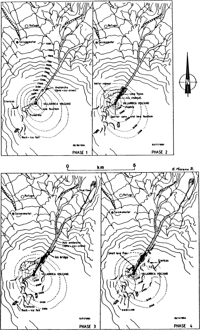 |
Figure 1. Sketch map of the summit area and N flank of Villarrica on 30 October and 3, 13, and 18 November 1984. Courtesy of Hugo Moreno. |
"Lava was emitted continuously from the central crater, advancing toward the NNE, where it melted the ice cover and formed a channel that was estimated to be 30-40 m deep, 50 m wide, and 1 km long during aerial observations 2-3 November. The central crater was occupied by a small flat spatter cone showing weak Strombolian activity. Lava from a small lake at the NNE foot of the spatter cone poured into the ice channel. Over the flat bottom of the channel, formed by solidified black lava, two narrow red lava flows were observed. Voluminous quantities of water vapor emerged from the area where the lava flow front was in contact with the channel's steep ice wall. Numerous fissures were present in the ice surrounding the channel, and on 3 November the ice cover on the SW flank also showed several deep fissures (phase 2, figure 1).
"Weather conditions obscured the volcano 4-5 November, but seismometers operated by the Universidad de la Frontera at Temuco recorded intense shallow seismicity (0-1 km depth), [tremors] and B-type [earthquakes] (table 1).
Table 1. Number of B-type events and [tremors] recorded by seismometers at Temuco, from 4 November, 2100, to 0635 the next day.
| Date | Time | B-type | Tremors |
| 04 Nov 1984 | 2100-0100 | 4 | -- |
| 05 Nov 1984 | 0100-0200 | 5 | -- |
| 05 Nov 1984 | 0200-0300 | 9 | -- |
| 05 Nov 1984 | 0300-0400 | 8 | -- |
| 05 Nov 1984 | 0400-0500 | 3 | 4 |
| 05 Nov 1984 | 0500-0600 | 8 | 2 |
| 05 Nov 1984 | 0600-0635 | 9 | -- |
"There were no signs of eruptive activity 6-9 November, although tremors and underground rumbling were reported at Pucón. Strombolian activity at the small spatter cone in the central crater resumed 10-12 November, and lava flowed NNE into the ice channel. The speed of the flow was estimated at 10 m/s.
"As of midday on 13 November, almost 2 x 10⁶ m3 of lava had flowed into the ice channel, most of which was concentrated at the lava front under the ice cover. At 1350 on the 13th, the lava front emerged onto the surface, generating a 3 km-long avalanche of lava blocks, ice, and snow, and leaving behind a 150 m-long ice bridge. Since only a very small mudflow moved downstream, it seems that most of the water generated by melting of the ice evaporated. New fissures were observed on the ice-covered SW, E, and NE flanks (phase 3, figure 1).
"Eruptive activity decreased 14-17 November, with only weak fumarolic emissions seen at the spatter cone and water vapor emission at the ice bridge. [Earthquakes] were reported 13 km E and 10 km SW of the volcano (at Palguin and Chaillupen).
"On 18 November, a clear deformation of the SW slope was observed between 2,200 and 2,800 m above sea level. Weak lava production from the central crater opened a new small ice channel, about 200 m long and 50 m wide, toward the N (phase 4, figure 1).
"Villarrica's October-November eruptive behavior is quite similar to the 1971 eruptive cycle that ended in a big lava effusion (29 December at 2345). Villarrica last erupted 11 August and during the first week in September, with small explosions and tephra emissions."
Information Contacts: O. González-Ferrán, H. Moreno R., and L. López E., Univ. de Chile, Santiago; P. Riffo A. and G. Fuentealba C., Univ. de la Frontera, Temuco.
Lava flow to N foot; lahar; pyroclastic cone collapses
Between 16 November and 1 December, activity remained constant. The lava column maintained its pressure and level in the central crater, and there were small explosions and gas emissions. Strombolian activity increased 1-6 December. Tephra was ejected to about 100 m height every 10 minutes. Lava from the lake in the central crater continued to pour out slowly through the initial NE flank channel.
On 6 December between 1200 and 1500 there was a violent increase in the rate of lava production. Lava flowed out through a new channel NE toward the Río Correntoso (which turns NW and flows about 20 km into Lake Villarrica), reaching the base of the volcano. The activity generated a small lahar that flattened a small wooden bridge and affected houses beside the river. The volume of water returned to its normal level after 24 hours. An overflight of the crater revealed that the level of the lava lake was higher than before and the pyroclastic cone had grown higher than the central crater rim. Intense Strombolian activity continued 7-10 December. Pyroclastic material was ejected to 50-100 m height. Very liquid lava continued to pour out of the crater to the NE. Activity decreased gradually 11-19 December. Small explosions occurred 20 December but the pyroclastic cone and lava lake collapsed and effusive activity ended.
Explosive activity resumed 12 January between 1015 and 2300. A column of pyroclastics reached about 400 m height. A sequence of explosions ejected incandescent material to 100 m. On 18 January, the pyroclastic cone and lava lake in the central crater had completely collapsed.
Information Contacts: O. González-Ferrán, Univ. de Chile, Santiago.
Small lava fountains and ash; increased seismicity
The following is a report from Gustavo Fuentealba Cifuentes.
"When the last eruptive cycle of Villarrica Volcano (30 October-26 February) began to decay in January 1985, seismic activity also decreased. Between January and June 1985, the seismograph located on the N flank of the volcano recorded a monthly average of 15 volcanic earthquakes (Minakami's B-type). In February, only five seismic events were recorded with very little harmonic tremor. However, since June 1985 volcano-seismic activity has increased significantly. At the same time, notable harmonic tremor was observed. Figure 2 shows monthly seismic activity between January and November 1985. This situation was continuing as of 25 November, with a small gap in mid-late November. On 19 November at 0700, harmonic tremor stopped abruptly, and only apparently very shallow seismic activity was recorded. On 21 November at 1000, harmonic tremor activity resumed.
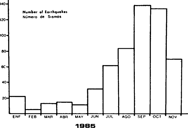 |
Figure 2. Number of earthquakes per month at Villarrica, January-November 1985. Courtesy of Gustavo Fuentealba C. |
"According to personal observations and reports from Pucón, a town at the N foot of the volcano, an increase in fumarolic activity and lava fountaining with weak explosions and very small ash emissions have been registered since April. A red glow has been seen at night since late September."
Further References. Acevedo, P., and Fuentealba, G., 1987, Antecedentes de la actividad microsísmica del volcán Villarrica relacionada con la erupción de Octubre de 1984: Boletín de Vulcanología (Universidad Nacional, Heredia, Costa Rica), no. 18, p. 13-17.
Moreno, H., Fuentealba, G., and Riffo, P. (in press), The 1984-1985 eruption of Villarrica, southern Andes of Chile (39°21'S): Basaltic Lava Flows Furrowed the Ice Cap.
Information Contacts: G. Fuentealba C., P. Riffo A., and P. Acevedo, Univ. de La Frontera, Temuco; H. Moreno R., Univ. de Chile, Santiago.
Lava lake activity
Boris Behncke reports that lava lake activity was observed at Villarrica in October 1988, by a student from Rühr Univ, Bochum. The summit crater, ~ 150 m deep, included a small cone that contained a vigorously bubbling lava pool roughly 50 m in diameter. Spatter was occasionally ejected above the crater rim. The lava lake activity had apparently been continuing since the end of the more vigorous 1984-85 eruptive activity.
Information Contacts: Boris Behncke, Rühr Univ, Bochum, Germany.
Weak explosions
An increase in fumarolic activity and weak explosions were observed in the crater during August-September. On 26 August, water in a nearby river (Río Carmelito) was cloudy and the river level abnormally high. Four days later, on 30 August, small ash emissions and continuous explosions were observed from 1430 to 1500, followed by a strong explosion at 1506. A weak emission of gray ash and a white gas plume 1 km high were observed on 17 September. Seismicity was at normal levels for the volcano.
Information Contacts: G. Fuentealba and P. Riffo, Univ de la Frontera.
Volcanic earthquakes and tremor
Seismicity was recorded at the volcano during March-May by a telemetered seismic station (VNV) 4.5 km from the summit, at 1,400 m elev. The average tremor frequency decreased slightly from 1.9 Hz (in March-April) to 1.8 Hz (in May). Tremor frequency also decreased with distance from the summit. Average frequencies of 1.9, 0.8, and 0.6 Hz were recorded 4.5 km (station VNV), 18.7 km (station PP) and 21 km (station PL) from the volcano, respectively, in April. Since 28 May, activity has increased, and both tremor and volcanic earthquakes have been recorded.
Information Contacts: G. Fuentealba and P. Peña, Univ de La Frontera; M. Petit-Breuilh, Fundación Andes, Temuco.
Phreatomagmatic explosions and intense fumarolic activity
Phreatic explosions 300-400 m high were observed from a town 15 km from the volcano every two minutes beginning at 1350 on 11 September. Fumarolic activity was intense. Activity decreased on 14 September. Seismicity was recorded earlier this year during March-May.
Information Contacts: G. Fuentealba and M. Murillo, Univ de la Frontera.
Ash eruption builds two new cones
Explosions began on 3 November at 1640. Sebastián Moraga, a forest guard at Villarrica National Park, felt ~ 240 explosions in the next 3 hours. At 1940, a vigorous explosion ejected ash, which fell on a 200 x 250-m area on the NW flank. At the same time, the telemetering seismic station (operated by the Univ de la Frontera) 4.5 km from the crater recorded a strong increase in seismicity. The next day at 1326, a new explosion was felt by the forest guard. A plume drifted toward the SW that afternoon.
Tourists reported two new small pyroclastic cones on 6 November. The cones exhibited intense explosive activity and underground noises. Ash deposits were visible on NW-flank snow on 9 November. Clouds obscured the volcano on 10 November, but a portable seismograph (in Lican Ray) and a flank telemetric station recorded an increase in tremor amplitude and frequency.
Information Contacts: G. Fuentealba and M. Petit-Breuilh, S.A.V.O. Seismological Team, Univ de la Frontera, Fundacion Andes, Temuco.
Spatter ejected from small summit vent; strong fumarolic activity
Jeff Witter climbed Villarrica on 17 November and observed summit-crater activity for about an hour. The circular main crater, ~ 200 m in diameter and 100 m deep, had vertical sides and a flat floor covered by black spatter. Gas flux was vigorous and continuous from an incandescent pit, 5 m in diameter, ~ 20 m E of the center of the crater. At intervals of ~5-10 minutes, roughly 2 m3 of spatter were ejected from the pit to 15 m height. Sounds similar to ocean waves also emanated from the pit. After about 30 minutes of observations, a 2 m2 section of the crater floor collapsed, enlarging the pit. Five more glowing pits, none more than 0.5 m across, were visible along the E edge of the crater floor. No tephra was found on the surface of snow and ice in the summit area, although convection carried small scoria fragments to as much as 130 m above the crater floor.
Moderate fumarolic activity occurred from a 20 x 10 m area on the SW rim, and from a 10-m vent ~ 5 m N of the main crater rim. Gases were strong-smelling and caused a burning sensation in the eyes, nose, and lungs. Fumarolic activity appeared stronger the next day, when observations from the entrance to Villarrica National Park (~ 7 km away) revealed a white billowing vapor cloud enveloping the entire summit area.
Information Contacts: G. Fuentealba, Univ de la Frontera; J. Witter, Occidental College, Los Angeles.
Weak explosions and seismicity
Activity continued during December with weak explosions in the summit crater. Numerous tremors were recorded by a telemetering flank seismograph.
Information Contacts: G. Fuentealba, SAVO, Univ de la Frontera.
High-frequency seismicity increases
The telemetered seismic station located 4 km NW of the main crater at 1,400 m elev recorded 11 high-frequency events (A-type) in June, compared to 3 in May, 1 in April, and 1 in March. Since March, ~ 25,000 tremor episodes have been recorded; ~ 6,000-7,000/month.
Information Contacts: G. Fuentealba, M. Murillo, M. Petit-Breuilh, and P. Peña, SAVO, Univ de la Frontera, Fundación Andes; J. Cayupi, SERNAGEOMIN.
Minor ash-falls to SE and W; recurrent tremor
Beginning about 0730 in the morning of 26 September residents of the Centro de Ski Villarrica-Pucón (a ski resort) saw "scrolls of black vapor" emitted about once each minute from the main crater of Villarrica volcano. Vapor rose ~500-750 m above the summit. . . . Four such small explosions took place in the morning, the last, at 1100, coincided with a strong tremor felt at the ski resort.
Figure 3 shows the ash distribution seen by aerial observers in the upper part of the ski area (Piedra Blanca). The distribution was composed of thin ash chiefly visible due to the contrast with the white snow. One part of the ash distribution was bounded by a SE-trending band of heavier deposition. This ash fall deposit extended over 8 km, visible to the east as far as the limit of contrasting background snow.
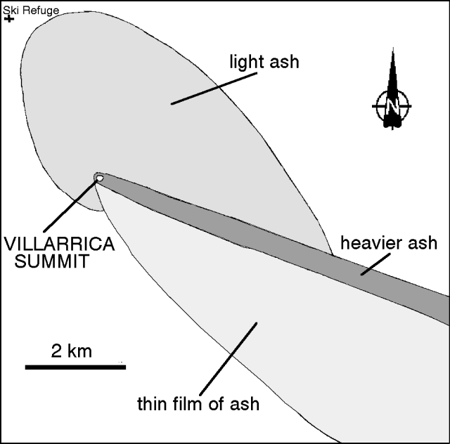 |
Figure 3. Ash distribution following the 26 September 1994 Villarrica eruption (mapping by Hugo Moreno on 26 September). |
Later on 26 September, between 2030 and 2130, observers saw incandescence above the crater that they attributed to glowing lava in the crater reflected in the fumarolic column. The next day (27 September) was partly cloud-covered, but strong fumarolic activity formed low-lying scrolls directed toward the E. Later, during a clearing in the clouds, observers saw a 500-m-long ash fall layer extending W.
Several seismic stations were installed on 26 September. Although two seismic stations were installed farther from the summit, it was not until 1630 that the station closest to the summit was installed near the Rio Voipir (at the 500-m contour, 13.5 km E of Villarrica). The record there showed continuous harmonic tremor along with other seismic events until about 2110. After that, and until 0600 on 27 September, tremor fell abruptly; however, three long-period volcanic earthquakes occurred in this interval. At 0700 harmonic tremor returned.
Starting at both 0741 and 0800 similar seismic sequences consisted of early events followed by a later event. The same sequence repeated about every 4 hours until the last one ended at 1000 on 28 September. The 4-hour sequence was interpreted as magmatic injections leading to gas-charged explosions. Thus, the main part of the eruptive episode lasted ~3.5 hours (0730-1100 on 26 September). It produced a magmatic eruption with a VEI of 1. The seismic signature associated with frequent gas-charged explosions was not previously seen at this volcano.
Information Contacts: H. Moreno, G. Fuentealba, and M. Petit-Breuilh, SERNAGEOMIN, Temuco.
Gas discharges and one thin ashfall in late December
Between 25 and 30 December the volcano discharged continuously. At 1000 on 25 December 1994 personnel of Villarrica National Park saw "a small scroll of dark vapor." The plume was estimated as <250 m tall and prevailing winds carried it toward the SE.
The next day at 0815 park rangers noticed a second plume, dark brown to black in color ultimately rising to about 600 m above the summit. Winds again carried this plume SE.
Informants reported that on 29 December they could detect a thin layer of gray ash discoloring all of the snow-covered SE sector of the volcano. They also saw a dark gray stain trending N 120° E reaching at least 6 km (to the Portezuelo Chinay area). That same day, Villarrica discharged gas at 20-30 second intervals that looked grayish to sky blue, apparently rich in SO2. Occasionally light gray to brown drab discharges were also noticed and tentatively interpreted as minor gaseous explosions with a fine-grained ash component.
On 30 December at 0800 and 1100, the volcano produced dense plumes of dark gray to dark brown color. These reached up to 250 m above the crater where they were carried to the SE. After noon a weather front crossed the region and the escaping gases condensed as a great mass and slid down the SE flank. No discharges were specifically reported after this event.
Seismic monitoring began at 1807 on 26 December using a portable MEQ-800 seismograph installed 13.5 km from the principal crater.
During the next few days, tremor was seen; it typically had an amplitude of 2 mm and fundamental frequencies 0.8 Hz. During the first 4 hours of operation, 20-30 second intervals of tremor occurred ~60 times/hour. The next day (27 December) tremor increased to 120 times/hour. Starting at 1700 on 28 December tremor increased still further and it reached higher frequency, up to 1.1 Hz. On 29 and 30 December tremor remained essentially constant in terms of amplitude and duration, but after 0100 on 31 December, intervals of tremor took place more often, an average of 200 times/hour (i.e. 200 distinct intervals of tremor an hour). The number of tremor intervals an hour remained constant until 2100 (31 December) when tremor dropped to the levels seen on 29 and 30 December.
The tremor on 26 and 30 December was similar to that seen routinely during times of repose. Nevertheless, some lower frequency events (~2 Hz) took place coincident with weak ash eruptions. As of 31 December 1994 no new activity was reported.
Information Contacts: H. Moreno, G. Fuentealba, M. Petit-Breuilh, and P. Peña, SERNAGEOMIN, Temuco.
Sketches of both the crater and ash lobes from late-December eruptions
Geologists who made an overflight of the stratovolcano late on the morning of 15 February (in conjunction with Simon Young and John Simmons) observed increasing fumarolic activity. Villarrica gave off moderate puffs of bluish, sulfurous gases at 1-2 minute intervals that rose 300-400 m above the crater before dispersing to the SE.
Between 1040 and 1245 on 15 February the local seismic station (VVN) registered an average of 3 tremor episodes per minute. This tremor had frequencies of 1.3-1.5 Hz, 0.3 Hz below the frequency customarily received (1.8 Hz), and considered a possible indication of a slightly deeper source than typical for both the tremor and the puffs. This behavior continued until 1900 on 15 February. Afterwards tremor diminished and puffing ceased at the fumaroles. These later conditions prevailed until at least 19 February.
The crater, a little more than 200 m in diameter, contained a nested terrace (figure 4). The inner crater floor sat ~200 m below the crater rim, the bottom 50 m of which was black in color, possibly composed of scoria. At the very bottom center an opening exposed ~20 m of material with a bright red glow.
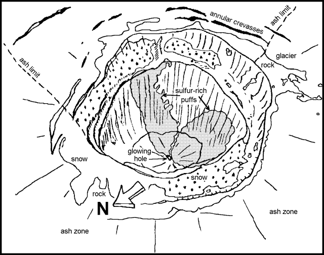 |
Figure 4. Sketch of Villarrica's crater as seen on 15 February 1995. Courtesy of J. Naranjo, G. Fuentealba, and P. Peña. |
Black ash on the glaciers of the E and S flanks extended 4.6 km in the S20 E direction and 2.5 km in the S direction (figure 5). These ash lobes could correspond to eruptions on 25 and 29 December 1994 (19:12).
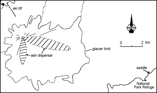 |
Figure 5. Distribution of black ash from Villarrica's crater as seen on 15 February 1995. Courtesy of J. Naranjo, G. Fuentealba, and P. Peña. |
Information Contacts: J. Naranjo, SERNAGEOMIN, Santiago; G. Fuentealba and P. Peña, SAVO.
Tremor, mild explosions, and a new pyroclastic cone
Gustavo Fuentealba contributed the following on 4 May. "Seismic activity has increased in the past few days compared to March. In mid-April explosions were visible to the level of the crater rim and these explosions coincided with seismicity registered on portable instruments 15 km from the crater. The seismic signals arrived at 90-second intervals.
"In agreement with mid-April explosions and seismic data, aerial observations and photos around that time (taken by members of the Corporacion Nacional Forestal) revealed the growth of a new pyroclastic cone. Starting on 28 April and 1 May, there were intervals of poor visibility, but a new increase in seismic activity included tremor at 30-second intervals. Seismic activity declined suddenly, starting about 1915 on 1 May, but it reappeared ~8 hours later with tremor at 60-second intervals. Although continued poor visibility thwarted direct observations, it was thought probable that the April pyroclastic cone had collapsed."
Information Contacts: Gustavo Fuentealba1 and Paola Pena, Observatorio Volcanologico de los Andes del Sur. 1 Also at Universidad de la Frontera, Ciencias Fisicas, Avenida Francisco Salazar 01145, Casilla 54-D A 238, Temuco, Chile.
Seismic increase a week prior to a 14 September ash emission
Seismicity at Villarrica stratovolcano increased above background starting on 7 September. The seismic data lacked significant high-frequency response. This increase preceded ash emissions that took place about a week later. The events were recorded at the digital seismic station named "VNV" located on Villarrica at 1,500 m elevation; data is telemetered to the Universidad de la Frontera in Temuco.
At 1330-1335 on 14 September personnel of Chile's Programa Riesgo Volcánico (PRV) saw emissions of gas and ash generated by four rhythmic explosions. The resulting ash blanket covered 60,000 m2 and bordered the volcano's ski resort ("Ski Villarrica"), which lies ~4 km from the summit on the NW flank. Later, at 1427, a lower intensity gas emission was observed from the resort. No further emissions were seen. The eruptions were thought to have been due to degassing from shallow depth.
Information Contacts: Gustavo Fuentealba C., Eugenia Petit-Breuilh S., and Erasmo Hernández G., Programa Riesgo Volcánico de Chile (PRV), Observatorio Volcanológico de loa Andes del Sur, Departamento Ciencias Fisicas, Universidad de la Frontera, Avda. Francisco Salazar 01145, Casilla 54-D, Temuco, Chile.
Increased seismicity again in late September
Above-background seismicity started on 7 September (BGVN 21:08); a follow-up report indicated that Villarrica's microseismicity again increased starting on 26 September and was continuing as late as 3 October. The events seen were of short-duration with dominant frequencies of 1.75 Hz and they appeared in swarms (figure 6). Some isolated events occurred in the 0.7-1 Hz range. In this same time interval the crater was the scene of abundant to occasionally intense degassing.
 |
Figure 6. One of Villarrica's ongoing swarms of long-period seismic events (station VVN), 0900 to 0927 (GMT) on 26 September 1996. Reference marks are at one minute intervals. Courtesy of Gustavo Fuentealba and Paola Peña. |
Information Contacts: Gustavo Fuentealba C.1 and Paola Peña, Programa Riesgo Volcánico de Chile (PRV), OVDAS; 1-also at Depto. Ciencias Fisicas, Universidad de La Frontera, Temuco, Chile.
Crater observations for the interval 11 September 1996-13 January 1997
The following summarizes observations of eruptive activity during 11 September 1996-13 January 1997, based on descriptions by volcano guides and a visit to the volcano by Werner Keller in January 1997.
On 11 September 1996 a group of mountain climbers observed intense degassing of water vapor and reported that the small lava pond on the crater floor was not visible. On 14 September (BGVN 21:09) there was emission of ash accompanied by a dull rumbling noise. Guide Claudio Marticorena of Pucon was close to the summit with a group of tourists at the time of the ash emissions and reported that lava blocks tens of centimeters in diameter were ejected above the rim of the summit crater.
October and November were characterized by a notable rise of the magma column within the central crater pit, which was almost completely filled to its rim. Mountain guides Victor Sepulveda and Claudio Marticorena reported a vigorously convecting lava lake 50 m in diameter with fountaining from several areas of the lake. Frequent bursts ejected spatter and incandescent bombs beyond the summit crater, onto the upper flanks of the cone every few seconds. This activity lasted until mid-November 1996, followed by a rapid subsidence of the magmatic column and accompanied by strong vapor emission later that month. In December, the characteristic nocturnal crater glow observed at Villarrica during the past years disappeared.
Fumarolic emissions from the summit crater diminished in early January 1997, and on 4 January Sepulveda noted that the inner crater pit was again completely visible, for the first time since late November 1996. At that date, the central pit was ~100 m deep, with two small degassing vents at the bottom. No incandescent lava was visible in either of the vents, but gas emissions produced a distinct noise. The S part of the intracrater platform left after the 1984-85 eruption had collapsed into the central pit. On 13 January, mountain guides noted incandescent lava within the central pit: this suggested a new rise of the magma column.
Information Contacts: Boris Behncke, Geomar Research Center for Marine Geosciences, Wischhofstrasse 1-3, 24148 Kiel, Germany; Werner Keller, Wiesenstrasse 8, 86438 Kissing, Germany.
Strombolian activity and lava in central pit; red glow returns at night
In October and November 1996, activity was characterized by a rapidly convecting lava lake that nearly filled the central crater pit (BGVN 21:12). Fountains were noted on the lake's surface and frequent bursts ejected spatter and incandescent bombs beyond the summit crater. In December, the magmatic column subsided and the characteristic nocturnal crater glow disappeared. During the first two weeks of January 1997, incandescent lava returned to the central pit (BGVN 21:12). The following summarizes observations made from mid- January through mid-March by volcano guides Victor Sepulveda and Lorena Morales and documentary film makers.
The volcano guides reported that between 15 and 19 January few observations of the crater were made because of strong fumarolic activity. On 21 January a clear view revealed that the crater was unchanged since 13 January (BGVN 21:12). That day two small ash emissions from the summit crater were seen from Pucon, ~ 17 km N. The cause of these emissions may have been a landslide in the E crater, detected on 27 January. On 3 February, the crater floor was partially covered with talus, but a small vent was actively degassing in the N part of the crater floor. Another significant collapse of the NE crater wall occurred sometime before 15 February. By 17 February, two vents on the NE side of the crater floor had small Strombolian eruptions and extruded incandescent lava onto the crater floor. On 22 February, small lava fountains on the NE side of the crater floor were actively filling the crater with lava.
On 24 February, the guides reported that the crater floor had risen by several meters and convection was occurring within the lava pond. The film crew noted that two red spots in the crater produced irregular Strombolian activity, gas emissions, and strong noises. The film crew also reported that strong sulfur emissions required them to wear gas masks while at the summit and that these emissions appeared to be extruded from vents at the ash-covered icefields on the upper terrace in the crater (figure 7, number 1).
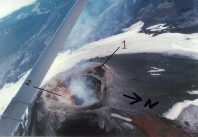 |
Figure 7. Aerial photo of Villarrica's summit taken 2 March, 1997, looking WSW. Visible features include the fumarolic vents at the ash-covered icefields (1) and the collapsed S terrace (2). Courtesy of Monika Steinmetz. |
During late February the film crew reported seeing a light red glow at night above Villarrica's summit crater. These reports were confirmed by the volcano guides report of residents in Pucon seeing the glow on 2 March following several months of absence.
The documentary film crew took a summit overflight on 2 March and reported a change in crater morphology due to the collapse of the S terrace (figure 7, number 2). When they returned to the summit on 5 March there were no further morphological changes in the crater and degassing appeared the same as on 24 February.
On 12 March, the volcano guides observed a light dusting of ash that covered the NE flank of the volcano. Strombolian explosions from a vent on the crater floor continued throughout the remainder of March.
Information Contacts: Werner Keller, Wiesenstr. 8, 86438 Kissing, Germany; Boris Behncke, Geomar Research Center for Marine Geosciences, Wischhofstrasse 1-3, 24148 Kiel, Germany; Monika Steinmetz and Jürgen Kendzior, Carmanah Film and Fotodokumentationen, Klausenmühle 5, 64625 Bensheim, Germany.
Explosions during March-June; crater glow in August
As reported by volcano guides on 17 February, two vents on the NE side of the crater floor had small Strombolian eruptions and extruded incandescent lava onto the crater floor (BGVN 22:04). On 24 February the guides reported that the crater floor had risen by several meters. Residents of Pucon (~17 km N) noted night glow on 2 March following several months of absence. Weak Strombolian explosions continued throughout the remainder of March.
The following describes visual observations made from April through August 1997 by members of the Villarrica Observation Project/Internet (POI) from Pucon. Table 2 presents observations since mid-October 1996.
Table 2. Summary of activity observed at Villarrica during October 1996 through August 1997. Courtesy of Werner Keller.
| Date | Description of Activity |
| Mid-Oct to mid-Nov 1996 | Notable rise of the magma column in the central crater pit. |
| Late Nov 1996 | Subsidence of the magmatic column. |
| Dec 1996-03 Jan 1997 | Strong vapor emissions. |
| 04 Jan 1997 | Inner crater pit completely visible without incandescent lava. |
| 15-19 Jan 1997 | Strong fumarolic activity. |
| 21 Jan 1997 | Two small ash emissions from the summit crater. |
| 17-24 Feb 1997 | Small Strombolian eruptions from two crater vents. Lava fountains actively filling the crater, raising the crater floor by several meters. Convection within the lava pond. |
| 02 Mar 1997 | Reappearance of night glow above the crater. |
| 12 Mar 1997 | Light dusting of ash seen on the snow-covered NE flank. |
| 15 Mar-Apr 1997 | Strombolian explosions from a crater vent. |
| Mid-May 1997 | Incandescent bombs ejected over the crater. |
| 22-31 May 1997 | Small ash puffs from the summit crater. |
| June 1997 | Small Strombolian explosions. |
| 10 Jul 1997 | Nocturnal red glow disappeared. |
| 17-19 Jul 1997 | No sign of fumarolic activity. |
| 22 Jul 1997 | Reappearance of weak fumarolic activity. |
| 31 Jul 1997 | Weak night glow over the summit after 21 days of absence, indicating infilling of the crater floor with incandescent lava. |
| 19 Aug 1997 | Glow over the summit without degassing. |
| 25-29 Aug 1997 | Glow and fumarolic activity disappeared. |
The lava pond in the crater interior continued with small Strombolian eruptions throughout April 1997 and could be observed during clear nights as a red glow above the summit crater. The parallel fumarolic activity was moderate and mainly consisted of vapor. In May the activity of the lava pond increased considerably with respect to degassing intensity and frequency. At night incandescent bombs could be seen every 5 minutes. On 22, 23, 24, 30, and 31 May small ash clouds were regularly emitted to ~200 m above the summit.
In June, due to the beginning of winter, few observations of the summit could be executed. Nevertheless short periods of clear weather made possible a view of the activity level of the crater indicating small Strombolian explosions every 2 minutes. On 10 July observers realized that the red nocturnal glow had disappeared, hinting at subsidence of the magma column. Between 17 and 19 July the summit showed no more signs of fumarolic activity. On 22 July small fumarolic emissions were registered again. On 31 July weak night glow reappeared over the summit after an absence of 21 days.
On 19 August the glow reached the same intensity as in June. The crater did not show any explosive activity, indicating slow uplift of basaltic lava with low gas contents. Observers confirmed that the magma column had subsided again on 25 August for the second time this year and that the fumarolic activity was interrupted.
Information Contacts: Werner Keller, Proyecto de Observación Villarrica/Internet (POVI), Wiesenstr. 8, 86438 Kissing, Germany (URL: https://www.povi.cl/).
Earthquake swarm in late October
During March-August 1997 seismic activity at Villarrica included 1.5-2.7 Hz tremor and isolated long- period (LP) events associated with phreatic explosions. The latter are common occurrences that have taken place in previous years. Such intervals of elevated seismicity correspond with increased volcanic activity and often include larger amplitude LP earthquake swarms. Although during several days in mid- to late-May 1997 the amplitudes rose to about 20 Real-time Seismic Amplitude Measurement (RSAM) units, around 7 September they reached up to 40 RSAM units and on many days of the month peaks were above 20 RSAM units. Strombolian explosions and night glow were observed between April and August (BGVN 22:08).
Lasting at least eight days, an earthquake swarm during 20-28 October produced RSAM amplitudes an order of magnitude larger than previous months, to >200 units (figure 8). Researchers proposed that October- December swarms may have some seasonal influence associated with higher temperatures in the summer.
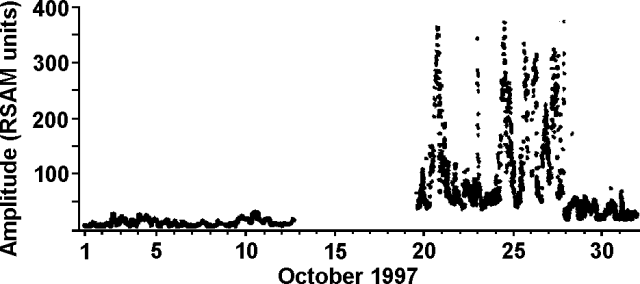 |
Figure 8. Seismic activity at Villarrica during October 1997. The system at the observatory is triaxial with a 1-second period; it was inoperative during mid-October. Courtesy of the Seismological Team, Observatorio Volcanológico de los Andes del Sur (OVDAS). |
Information Contacts: Gustavo Fuentealba C. and Paola Peña S., Seismological Team, Programa Riesgo Volcánico de Chile (PRV), Observatorio Volcanológico de los Andes del Sur, Departamento Ciencias Fisicas, Universidad de la Frontera, Avda. Francisco Salazar 01145, Casilla 54-D, Temuco, Chile.
Escalating seismic amplitudes in March prelude to more explosions and ash
Luis Hernan Ecueñique, a manager in charge of "Las Cavernas," a tourist attraction 8 km from Villarrica's active crater, noted that during late March through at least early April there had been an ascent of magma in the central crater. Erupted material reached ~100 m from the crater's edge. Local tour guides had also informed him that explosions had deposited tephra on the N flanks. Measurements within "Las Cavernas" (which are lava tubes) indicated the air temperature rose by about 2°C.
A digital seismic station 21 km from the crater failed to detect either an increase in the number of seismic events or a shift in their character; the system did register a minor increase in event amplitude.
Information Contacts: Gustavo Fuentealba1 and Paola Peña S., Observatorio Volcanológico de Los Andes del Sur (OVDAS), Manantial 1710-Carmino del Alba, Temuco, Chile; 1Universidad de La Frontera (UFRO), Departamento Ciencias Fisicas, Universidad de la Frontera, Avda. Francisco Salazar 01145, Casilla 54-D, Temuco, Chile.
Summary of February-November activity; intermittent lava pond pulses, phreatic explosions
This report summarizes daily visual observations by members of the Proyecto de Observación Villarrica (POVI), volcano guides, and other sources during February to November 1998. In late February, after two months of subsidence, the magmatic column reached the crater floor with a weak and irregular degassing. By mid-March the lava pond was clearly visible as an intermittent red glow from 12 km away. In April and May, three convective magmatic pushes, gas-poor, filled half of the funnel-shaped crater with pahoehoe lava. On 13, 25, and 30 June, small phreatic emissions rose up to 200 m above the summit. Since mid-October, the activity level in the lava pond has varied, with the low levels of degassing intensity occurring at irregular intervals. On 8 November, the red glow was seen for the only time that month.
It is inferred that the red glow indicates that a small volume of usually gas-enriched magma has reached the crater floor in phases and at irregular intervals. This causes a sudden occurrence of the glow, sometimes with increasing intensity and lasting from a few hours up to 3 days. Subsequently, a distinct reduction of the glow intensity is interpreted to mean that an insufficient supply of convecting magma and gas allows the lava pond to form a crust. During the report period, 16 such magmatic pulses were observed and 10 additional pulses were inferred for periods of non-observation due to weather conditions.
Information Contacts: Werner Keller U., Proyecto de Observacion Villarrica (P.O.V.I.), Wiesenstrasse 8, 86438 Kissing, Germany (URL: https://www.povi.cl/).
Three years of seasonal fluctuations in lava pond height
This report summarizes daily visual observations by members of the Proyecto de Observación Villarrica during December 1998 to March 1999. From mid-October through November 1998 team members noted a descent in the lava pond and a drop in visible activity (BGVN 23:11). On 2, 3 and 5 December 1998 a faint red glow was visible above the summit. Afterwards the magma was thought to have reached its lowest level.
When Jürg Alean visited the summit on 21 January, the faint noises caused by degassing could be clearly heard. No recent impacts of bombs were seen in the crater. Early on 5 February, after a break of 2 months, the lava pond reappeared on the crater floor. At about 1300 on 21 February observers saw several dark ash and gas emissions. During 1-26 March the summit remained cloud-covered but apparently little magmatic activity occurred. In the evenings of 29 and 31 March, observers saw glowing pyroclastic material ejected from the crater.
During 1998 the magma column underwent a complete cycle of activity. In January 1998 the column had reached its low; during February-March, the column began slow ascent. From March to September, the column reached hydrostatic equilibrium with its upper surface at the crater floor and this accompanied displays of weak-to-moderate Strombolian eruptions and convective activity in the lava pond. During October-December the column slowly subsided and by January 1999 it again stood at a low level in the vent.
This seasonal sequence has been observed in successive years since 1997 (BGVN 22:04 and 22:08). The seasonal changes in snow and ice mass on the volcano and a well-developed hydrothermal system may affect the magma within the volcanic edifice in a cyclic manner.
Information Contacts: Jürg Alean, Stromboli On-Line, Rheinstrasse 6, CH-8193 Egisau, Switzerland (URL: http://www.swisseduc.ch/stromboli/); Werner Keller Ulrich, Proyecto de Observacion Villarrica (P.O.V.I.), Casilla 150, Correo Villa La Reina, Santiago, Chile (URL: https://www.povi.cl/).
Increased tremor and small ash explosions
The following report, from the scientific team at the Observatorio Volcanologico de Los Andes del Sur (OVDAS), is for the period 20 August through 11 October 1999.
Since 22 August, seismic activity at Villarrica has increased from background levels, shown by an increase in the amplitude of harmonic tremor signals registered at station CVVI, located 19 km from the crater. Periods of high-amplitude tremor lasting 2-30 hours occurred, alternating with background-level tremor (banded tremor). Elevated levels of harmonic tremor lasting for hours-days preceded the last eruption in 1984. OVDAS has therefore recommended to local authorities a move to Level 2 (Green) in the "Semaforo" (traffic light) alert scheme adapted for Villarrica. If the harmonic tremor increases further in amplitude or high levels are maintained for longer periods, recommendations will be made to move to Level 3 (Amber). An energetic long-period event on 15 September, the culmination of this period of high-amplitude tremor, is considered to have been associated with a small explosive event in the crater and ash emission.
The level of seismicity rapidly decreased after 15 September to unusually low levels. Magma level in the crater lake however, is inferred to have been high on 25 September from nighttime observations of glow. Observations by local residents suggest that during the early morning of 26 September a second explosion occurred, depositing new ash. This event was not registered by CVVI so is considered to have been less energetic than the first.
On 1 October, OVDAS scientists on a helicopter flight observed that the level of the magma lake was unusually low (~200 m below the crater rim). The incandescent lava was only visible through a small opening (20-30 m) in a solid crust. Ashfall deposits extended ~5 km ESE from the crater. The deposits clearly exhibited two components, that of the Strombolian fountain (proximally) and that of the upper ash plume. A further increase in tremor amplitude and frequency was observed on 3 October. Observations of new ash and projectiles on the crater rim on the 4th suggested that this tremor episode also culminated in a small explosive event.
A new type of seismic signal, apparently strong hybrid earthquakes, was also registered at the VNVI seismic station (4 km from the crater). They have been increasing in number since 1 October (typically 2-3/day) and are not associated with any visible activity. These events do not comprise the normal background activity.
Information Contacts: Gustavo Fuentealba1, Paola Peña S., and Eliza Calder, Observatorio Volcanologico de Los Andes del Sur (OVDAS), Casilla 23D, Temuco, Chile (URL: http://www.sernageomin.cl/); 1-also at Universidad de La Frontera (UFRO), Departamento Ciencias Fisicas, Universidad de la Frontera, Instituto del Medioambiente, Avda. Francisco Salazar 01145, Casilla 54-D, Temuco, Chile.
During 2000 a still-active lava lake, occasional outbursts, and increased lahar risks
This report reviews activity during January-May 2000 and September-October 2000. Observations from January through May 2000 were provided by the Proyecto de Observacion Villarrica (POVI). Information about increased seismicity in September and explosions in October were provided by the Observatorio Volcanologico de Los Andes del Sur (OVDAS). Reports for the period June-August 2000 were not available.
Activity during January-May 2000. In January activity was at normal levels. Explosive energy of gas bubbles and incandescence from the lava lake decreased with respect to late 1999. Strombolian activity was observed on 20 January. During February incandescence could be observed on 14 clear nights, indicating weak magmatic activity. Stronger glow was observed on the nights of 19-20 February.
During 1400-1500 on 1 March a series of phreatic events was marked by gas-and-ash emissions. Magmatic activity within the crater decreased with respect to February to more typical levels, causing less incandescence. Activity continued to diminish in April and illumination at the summit also decreased. Incandescence at Villarrica's summit ceased during 5-29 May for the first time since 21 August 1999. At 1430 on 30 May, however, gas-and-ash emissions were observed. Overall, the level of activity was average.
Activity during September-October 2000. As of 20 September, an increase in seismicity occurred at stations VNVI and CVVI while gas and steam emissions ceased, and the usually persistent fumarole disappeared. During 25-28 September, seismic stations VNVI, 4 km from the crater, and CVVI, 19 km from the volcano, recorded anomalous seismicity characterized by clusters of low-frequency earthquakes, harmonic tremor, and tremor bands (periods of tremor separated by seismic silence).
OVDAS raised the hazard status to Green Level 2 on 3 October, indicating that the zone near the crater was dangerous. A flyover of the summit was performed on 4 October to observe any changes in activity. Fumarolic emissions remained absent, and the crater floor was obstructed by black rock. The crater bottom and walls were covered with patches of snow, indicating relatively low temperature. OVDAS prohibited ascents to the top of the volcano because of possible explosions or eruptions. Seismicity that day again showed tremor bands.
On 5 October, an observer of the Centro Volcanológico Villarrica (CVV) reported a short ash eruption with ashfall S towards Coñaripe. At the same time, researchers at the University of Hawaii detected a thermal increase at the summit crater by analysis of GOES 8/10 satellite imagery. Snow fell at the summit on the night of 5 October. An overflight on 6 October revealed a tenuous ash deposit under the recent snow. A small vent opened in the crater, and was subsequently closed by fresh lava. Seismicity included harmonic tremor.
Even a small explosion or eruption would be dangerous because of the potential dislodgement and melting of rock, ice, and snow capping the summit, which could generate a debris flow. Critical locations where lahar risk was highest were determined on the morning of 7 October to prepare for a possible eruption. Crews worked to clear and deepen river channels on or near Villarrica to help reduce damage from a potential lahar. A parapet was also constructed to protect the city and airport of Pucón from debris, ash, or lava flows. Seismicity in the morning showed harmonic tremor, while in the afternoon tremor bands were recorded.
At 1745 on 8 October, a traveler to Coñaripe observed black material rising rhythmically to ~30-50 m above the crater rim and falling back inside. At 1810 there was a small 45-minute-long ash eruption, and wind carried the ash SE. Seismographs indicated harmonic tremor at base levels and at 1400 on 9 October, tremor bands were recorded. An aerial view of the summit on 15 October showed a solid and fractured lava crust on the bottom of the crater and very low gas emission that was mainly water vapor caused by the melting and evaporation of small blocks of ice and snow that fell into the crater. Seismicity remained at a low level as of 15 October.
Information Contacts: Hugo Moreno, Observatorio Volcanologico de Los Andes del Sur (OVDAS), Casilla 23D, Temuco, Chile (URL: http://www.sernageomin.cl/); Werner Keller U., Proyecto de Observacion Villarrica (POVI), Wiesenstrasse 8, 86438 Kissing, Germany (URL: https://www.povi.cl/).
Pahoehoe steadily fills crater; gas discharges and explosions in October-December 2000
Since the last report (BGVN 25:10), Villarrica's summit crater continued to be active during October-December 2000.
October 2000 activity. On 18 October the crater bottom lay 70 m below the snow-and-ice-covered summit, it appeared solid and had no visible evidence of disturbance due to underlying fresh lava (figure 9). That night and through the following morning, however, the volcano emitted a small ash-and-gas plume that drifted ENE toward the community of Chinay-Palguín.
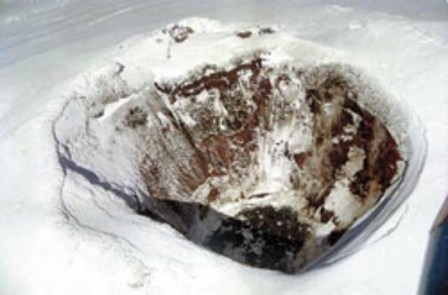 |
Figure 9. Photograph taken during a flight NE of Villarrica's summit crater during the day of 18 October 2000. Note the snow cover and no signs of activity. Photo by Antonio Varas, copyright Sociedad Periodística Araucanía S.A. |
On 24 October abundant thermal activity from the crater was observed. Ice and snow that fell from the crater rim down the crater sides and bottom generated enough steam to largely obscure the crater's base (figure 10). When observed on 27 October, the bottom of the crater had increased several meters in height due to outpouring of volatile-poor pahoehoe lava from a small incipient cone and other subsidiary vents (figure 11). Activity consisted of ejection of incandescent material about every 2 minutes, but was not accompanied by degassing sounds. By 30 October, lava had further filled the crater (figure 12, compare to figure 11), but the slow rate of lava discharge prevented the formation of a molten lava lake.
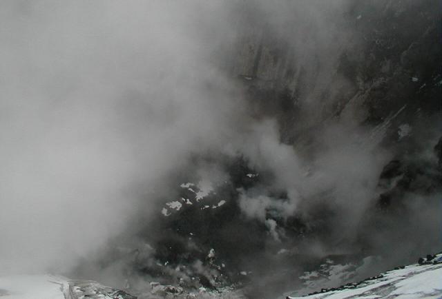 |
Figure 10. Villarrica's crater rim as viewed at 1540 on 24 October 2000. Abundant steam masks activity below, but indicates significant heating. Photo by Enrique Ferrada R., copyright Turismo Trancura. |
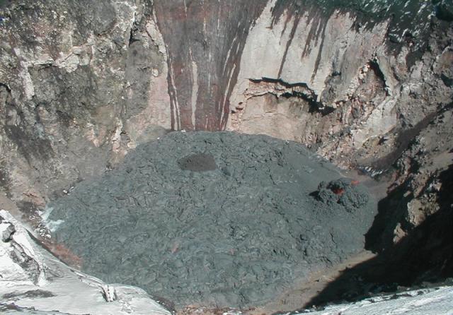 |
Figure 11. Villarrica's crater rim as seen on 27 October 2000. An incipient cone is visible near the right margin of the crater. The dark vertical patches on the internal wall were caused by melt water. Photo by Enrique Ferrada R., copyright Turismo Trancura. |
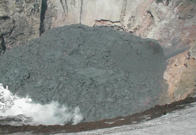 |
Figure 12. Villarrica's crater rim as viewed on 30 October 2000. By this time, the outpouring of fluid lava had built up the level of the crater bottom significantly. Comparing features on the back crater wall with those in figure 11 gives a sense of crater bottom growth. Photo by Enrique Ferrada R., copyright Turismo Trancura. |
November 2000 activity. The emergent crater bottom reached its maximum height on 1 November (figure 13). Weak incandescence (degree 1 on a scale of 1-5) and ejection of material every ~1-2 minutes could be observed from a point 13 km away that night. By this date the crater was filled with a volume of ~350,000 m3 of material, more than half its capacity. The average effusion rate was estimated to be ~0.45 m3/s during 24 October-1 November.
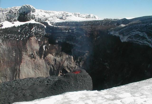 |
Figure 13. Villarrica, as viewed from the NW terrace of the crater on 1 November 2000. A pyroclastic cone with little Strombolian activity is visible in the center of the image. Photo by Enrique Ferrada R., copyright Turismo Trancura. |
December 2000 activity. Villarrica produced intense showers of lapilli that retextured the crater bottom during 3-5 December; further extrusion of pahoehoe lava filled up the minor depression of a collapse structure. Gas emission decreased, and a lava lake with a thin solidified crust and a 10-m diameter was observed by the end of the interval. Moderate incandescence (degree 3 on a scale of 1-5) and collapse of the cone were observed on 19 December (figure 14).
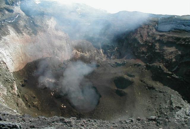 |
Figure 14. View of Villarrica's inner crater from the NE on 19 December 2000, showing a large central depression due to collapse, an active vent, and abundant gas discharge. Photo copyright Turismo Trancura and POVI. |
Explosive activity. The crater rim was blanketed by abundant ash and lapilli, and on the NW terrace several large bombs and blocks were found, evidencing one or several violent explosions during late 2000 (figure 15). A high risk of explosions remained at the end of the year because lava had grown to such a great height within the crater.
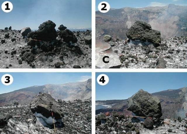 |
Figure 15. Villarrica's ejecta seen along the crater rim on an undisclosed date in late 2000, with a meter stick for scale. Labeled features are interpreted as follows: 1) a scoriaceous bomb more than 1 m in diameter; 2) a large block whose texture, morphology, and layering suggest that it originated from the crater base, "C" is a dense lithic block that was likely torn from the crater wall; 3 & 4) stratified fragments that originated from the crust that covers the crater bottom. Photos copyright Turismo Trancura and POVI. |
Information Contacts: Werner Keller U., Proyecto de Observacion Villarrica (POVI), Wiesenstrasse 8, 86438 Kissing, Germany (URL: http://www.povi.cl/); Hugo Moreno, Observatorio Volcanologico de Los Andes del Sur (OVDAS), Casilla 23D, Temuco, Chile (URL: http://www.sernageomin.cl/).
Small 14 May eruption; multi-year incandescence; crater visits
At Villarrica during 12-29 January 2001, incandescent lava was observed in the crater and ballistics were ejected ~10-30 m. Frequent explosions occurred, accompanied by degassing sounds that continued through February. During 23-29 March, incandescent lava was observed in the inner walls of the chimney to ~80 m depth. Incandescence was observed in the crater throughout April, and ballistics were ejected ~20-110 m as frequently as every 2-10 minutes during mid-April.
The most outstanding event of 2001 occurred on 14 May at around 1445. An eruption that lasted for 3-5 minutes sent a dark column of particles and gases up to ~1.5 km above the volcano. The eruption was presumably of phreatic origin (triggered by magma-water interaction).
After the eruption, observers continued to monitor Villarrica. This report covers crater visits through early August 2001. In addition, this report presents several years of incandescence and associated air-clarity data.
On 19 June, observers noted few changes in the crater compared to an earlier visit on 24 April. The crater floor contained a large opening, a chimney. Incandescence was observed in the opened upper portion of the sub-vertical chimney. The incandescence appeared along the chimney's ENE edge and could be seen to ~80 m depth. The chimney's cross-sectional form was circular, but on this visit it appeared to have shifted slightly toward the N and had increased in diameter (figure 16). Tephra, including ash (diameter under 2 mm) and lapilli (diameter in the range 2-64 mm), was seen scattered over a large area of Villarrica's snow-covered top, indicating recent outbursts and the potential danger of new explosions. During the visit, no fresh lava emerged at the top of the crater during almost 30 minutes of observation.
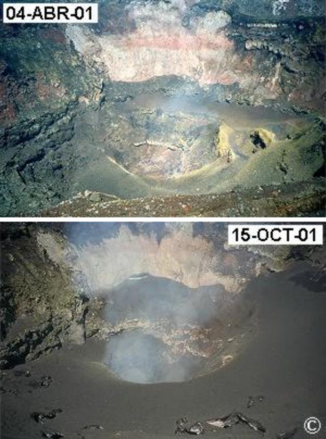 |
Figure 16. Two photos of the floor and lower inner walls of Villarrica's active crater, taken on 4 April and 15 October 2001 from the crater's N rim. In the latter photo the fresh tephra reached 15 m thick. Note the open, sub-vertical chimney disrupting the crater floor. Copyrighted photo courtesy of POVI. |
An interest in assessing the position and state of the lava lake from the vantage of an observation post at distance led workers to devise a means to record incandescence. Two indices were devised to describe conditions seen each night, based on qualitative visual estimates made by an observer 13 km to the NW of the crater. The monthly incandescence glow index (Indice de actividad incandescente mensual, IAIM) furnishes a qualitative estimate of incandescence. The monthly visibility index (IVNM) provides a qualitative estimate of atmospheric visibility (air clarity). For both indices, nightly observations assigned values on a scale from 0-5, and these were averaged for each month. The resulting plot shown here accounted for the number of clear nights each month and translated the axis from the index scale to 0-100 percent. Weather and season influence air clarity, the index for which generally ranged between 25 and 100%.
Figure 17 shows an ~4-year record of these estimates. Both indices showed significant variations, but also suggest a particularly strong rise in incandescence during June 2001. Observations on 19 June revealed fluctuations in degassing and brightness that occurred at ~5- to ~10-minute intervals. Observers noted that local ashfalls took place on 20 and 28 June, depositing zones of ash in the summit area.
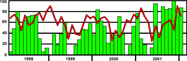 |
Figure 17. Qualitative indices of activity at Villarrica during February 1998 through January 2002 based on nightly visual observations from a distance. The histogram records a qualitative estimate of incandescence leaving the crater ("monthly incandescence index"). The line indicates a qualitative estimate of the air's clarity or the visibility ("monthly visibility index"). Larger percentages indicate greater clarity or higher incandescence. Incandescence was judged to be unusually large during June and August-December 2001; crater visits confirmed volcanism around those times. Courtesy POVI. |
A report on a 22 July visit stated that both incandescence and the level of the lava surface were low when compared to 19 June. Noise from degassing was weak. A landslide occurred at the inner edge of the central orifice. Although incandescence had decreased earlier, when visited on 9 August strong degassing occurred, and at 60- to 90-second intervals the chimney ejected ash, lapilli, and bombs (up to 20 cm across) toward the W and SW edges of the crater. Similar eruptions occurred on 16, 17, and 21 August. A 22 August visit revealed that the lava lake had risen ~40 m since 9 August.
In August observers on the crater's edge noted an increase in explosive activity, with ballistic heights of 50-150 m. Some scoriaceous bombs had diameters up to 50 cm.
As of October 2001, the rhythmical eruptions seen during the previous 3 months ceased. Material from those eruptions had formed a carpet of tephra that lay scattered around the chimney with thicknesses up to 15 m in the W part of the crater floor. Figure 7 compares the scene in the crater on 4 April to 15 October.
Incandescent lava was observed in the crater during September 2001 through January 2002, and ballistics were ejected ~80-150 m. Explosions generally occurred every ~1-10 minutes and at times degassing sounds were heard.
Information Contacts: Proyecto de Observacion Villarrica (POVI), Wiesenstrasse 8, 86438 Kissing, Germany (URL: http://www.povi.cl/).
General decrease in activity during February-May 2002
Our last report described activity at Villarrica during January 2001 (BGVN 27:02) through January 2002, when incandescent lava was observed in the crater and ballistics were ejected ~80-150 m. At that time explosions generally occurred every ~1-10 minutes and degassing sounds were occasionally heard.
During February through at least May 2002, sporadic observations showed a general decrease in activity. Degassing noises were sometimes heard; however, no incandescence or ballistics were reported. A crater visit on 9 April revealed that no incandescence or explosive noises occurred. The surface of the lava lake, last seen on 19 January, remained low (~200 m below the crater rim). On 10 April, explosions occurred every ~10-13 minutes.
Information Contacts: Proyecto de Observacion Villarrica (POVI), Wiesenstrasse 8, 86438 Kissing, Germany (URL: http://www.povi.cl/).
Active lava lake observed during late 2004
The last report of activity at Villarrica, through May 2002 (BGVN 27:06), described a general decrease in incandescence in the summit crater's lava lake, and noted ballistics ejected in January 2002.
Jacques-Marie Bardintzeff reported that climbers to the top of the volcano on 5 November 2004 noted a strong sulfur smell and observed projections of red lava at a depth of 200-300 m in the crater. On 16 November, a small lava lake was visible in the crater from the air; it was photographed on the 19th (figure 18). Many volcanologists attending the IAVCEI General Assembly at Pucón 14-19 November 2004 ascended and observed activity in the summit crater (figure 19). Although the lava lake itself lay at the bottom of a steep-walled inner crater and was not visible, periodic ejection of large quantities of incandescent lava fragments to a maximum height just above the rim of the inner crater could be seen from a bench below the SW rim of the outer summit crater (figure 20). Bardintzeff noted on 24 November 2004 that a white and blue plume of H2O vapor and SO2, extending to the E from Villarrica, was observed from Pucón. During the night, the plume was red colored. According to the local inhabitants, this was the first observation of a plume since January 2004.
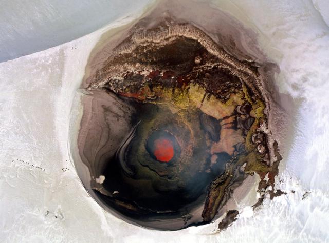 |
Figure 18. A near-vertical aerial view into the ~ 250-m-wide summit crater of Villarrica volcano at about 1430 on 19 November shows the incandescent lava lake in the steep-walled inner crater. The chain of dots left (north) of the crater are climbers near the crater rim. The photograph was taken through the side window of a Cessna aircraft executing an extremely sharp turn. Figure 19 (below) was taken from the upper left crater rim and figure 20 from the lower right. Courtesy of Jean-Claude Tanguy. |
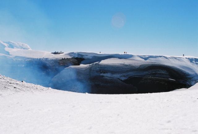 |
Figure 19. Climbers walk along the outer snow-covered rim of Villarrica's summit crater on 17 November 2004 and stand on a small bench just below the SW rim (left), which provided periodic views of incandescent ejecta from the inner crater lava lake (figure 20). Courtesy of Judy Harden. |
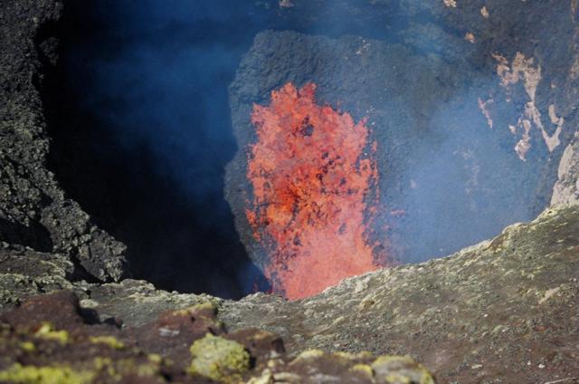 |
Figure 20. Incandescent spatter and bombs are ejected from the lava lake in the inner crater of Villarrica as seen from a bench just below the SW rim of the outer crater on 17 November 2004. Courtesy of Judy Harden. |
According to the Publicación Oficial del Grupo Projecto de Observación Villarrica (P.O.V.I.) website, incandescence was seen above the summit crater on the nights of 5-6 August and 27-28 October 2004 and frequently during November and December. On the night of 12-13 December Strombolian explosions every 2-5 minutes ejected incandescent spatter and bombs to 100 m height that landed on the outer crater rim. On the 13th the lava lake was ~ 30 m in diameter and at a depth of ~ 100 m. Vigorous convection of the lava lake was punctuated at intervals not exceeding 15 seconds by Strombolian explosions that ejected fine ash, lapilli up to 4 mm in diameter that fell to within a few meters of the inner edge of the crater, and incandescent spatter to the NE to heights of ~ 50 m. By 27 December solidification of ejected spatter around the vent had decreased its diameter by 2/3 with respect to 13 December, and Strombolian explosions at intervals of 2-5 minutes ejected material ~ 100 m above the vent. On 9 and 17 January minor explosions took place at intervals of 1-2 minutes. By 17 January fissures had formed around the N to E sides of the vent, and the opposite side of the vent edge, and the slope above it, had collapsed.
Satellite-based MODIS thermal alerts were first detected at 0345 UTC on 5 November and also occurred on 6, 16, 17, 22, 24, and 29 November, 5, 8, 9, 14, 19, 21, and 31 December, and 1 and 2 January 2005. Prior to 5 November 2004, MODIS thermal alerts not previously reported in this Bulletin had been detected at Villarrica on 23 May, 10 and 17 July, 2, 6, 25, and 27 August, 16 and 28 September, 2, 12, 14, 27, and 30 October, 1, 3, 22, and 28 November 2003, 31 January, 1-3, 7, 10, 12, and 14 February, and 0345 UTC on 26 March 2004 (2345 local time 25 March). According to the P.O.V.I. website, strong explosive activity ejected incandescent pyroclastic material on 28 August 2003, and except for three cloud-covered days, incandescence above the summit crater was seen daily from 27 January to 20 February 2004.
General Reference. Calder, E.S., Harris, A.J.L., Peña, P., Pilger, E., Flynn, L.P., Fuentealba, G., and Moreno, H., 2004, Conbined thermal and seismic analysis of the Villarrica volcano lava lake, Chile: Revista Geológica de Chile, v. 31, no. 2, p. 259-272.
Lara, L.E., and Clavero, J. (eds.), 2004, Villarrica volcano (39.5°S), Southern Andes, Chile: Servicio Nacional de Geología y Minería - Chile, Santiago, Boletin No. 61.
Information Contacts: Jacques-Marie Bardintzeff, Laboratoire de Pétrographie-Volcanologie, Bât. 504 Université Paris-Sud, F-91405 Orsay, France (URL: http://www.lave-volcans.com/bardintzeff.html); Judy Harden, Department of Geology, University of South Florida, 4202 E. Fowler Ave, SCA528, Tampa, FL 33620, USA; Publicación Oficial del Grupo Projecto de Observación Villarrica - Internet (P.O.V.I.) (URL: http://www.povi.cl/); Jean-Claude Tanguy, Univ. Paris 6 & Institut de Physique du Globe de Paris, Observatoire de St. Maur, 94107 St. Maur des Fossès, France.
Unusual seismicity, minor pyroclastic, and gas explosions, January-April 2005
Our last report on Villarrica, through January 2005, described plumes, the growth of a lava lake in the crater, and some night-time Strombolian explosions (BGVN 29:12). This report covers January to April 2005.
According to the March 2005 newsletter of the Multinational Andean Project: Geoscience for Andean Communities (MAP-GAC) produced by the Geological Survey of Canada, both seismic activity and degassing from the permanent fumarole increased in January. One of the early January explosions described above sent pyroclastic material (ash and scoriaceous lapilli) onto the flanks of the snow-and-ice covered volcano, covering an area 1 km wide and 3 km long. Subsequent minor explosions have sent pyroclastic material to estimated heights of 300 m above the crater. Onlookers have reported incandescent material within the gas-and-pyroclastic column.
On 19 January 2005, volcanologists Hugo Moreno and Edmundo Polanco of OVDAS–SERNAGEOMIN observed the lava lake actively spattering at a distance of 30 m below the edge of the principal crater; the crater interior and perimeter were covered in spatter. The glacier covering the cone had developed new fractures and crevasses. Activity in February 2005 lessened.
During 29 March to 3 April 2005, the lava lake inside Villarrica's crater remained active, with Strombolian explosions occurring. Some gas explosions were observed to hurl volcanic bombs as far as ~ 300 m. According to a news report on 12 April 2005, the Oficina Nacional de Emergencia reported that unusual seismicity was recorded at Villarrica during early April. Fresh ash deposits were seen outside of the volcano's crater. Visitors were banned from climbing the volcano.
Information Contacts: Werner Keller, Proyecto de Observacion Villarrica (POVI), Wiesenstrasse 8, 86438 Kissing, Germany (URL: http://www.povi.cl/); Hugo Moreno and Edmundo Polanco, Observatorio Volcanológico de los Andes del Sur (OVDAS), Servicio Nacional de Geología y Minería, Casilla 23D, Temuco, Chile (URL: http://www.sernageomin.cl/); MAP:GAC Newsletter, Geological Survey of Canada, 101-605 Robson Street, Vancouver, BC,V6B 5J3, Canada.
Nearly continuous satellite thermal anomalies observed since 2005
During 29 March to 3 April 2005, the lava lake inside Villarrica's crater remained active, with Strombolian explosions occurring. Some gas explosions were observed to hurl volcanic bombs as far as ~ 300 m. According to a news report, the Oficina Nacional de Emergencia reported that unusual seismicity was recorded during early April 2005. Fresh ash deposits were seen outside of the crater. Visitors were banned from climbing the volcano.
Since the beginning of 2005, relatively consistent and continuous MODIS/MODVOLC thermal anomalies were recorded during 1 January through 25 March, 7-21 July, 31 August through 26 September, 17 October through 25 December 2005, and 23 January through 4 September 2006 (figure 21). The gaps between these periods are probably artificial, due to such interference as cloud cover or other phenomena that obscured satellite observations. For example, the activity reported above for late March through early April 2005 did not generate MODIS/MODVOLC thermal anomalies.
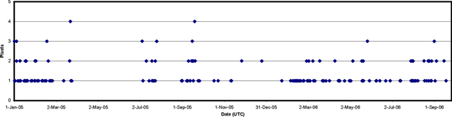 |
Figure 21. Thermal anomalies at Villarrica from the MODIS/MODVOLC satellite observations, January 2005 to 18 September 2006. Anomalies are from both the Aqua and Terra satellites. Courtesy of the HIGP MODIS Thermal Alert System. |
Information Contacts: HIGP MODIS Thermal Alert System, Hawai'i Institute of Geophysics and Planetology (HIGP), University of Hawaii and Manoa, 168 East-West Road, Post 602, Honolulu, HI 96822, USA (URL: http://modis.higp.hawaii.edu/).
Thermal anomalies throughout 2007; ash plumes November 2007 and October 2008
Our last report on Villarrica (BGVN31:08) discussed the nearly continuous thermal anomalies between 1 January 2005 through 4 September 2006. This report updates this information through 10 February 2009 and suggests ongoing activity from the lava lake inside Villarrica's small, deep summit crater. Seismic and textural insights on the volcano are discussed by Gurioli and others (2008).
MODVOLC thermal alerts were issued nearly continuously during September 2006. Alerts then followed during 26 October 2006 through 18 February 2007, during 29 April 2007 through 5 June 2007, during 9-11 July 2007, and during 6 September 2007 through 25 December 2007 (24 December local time). The gaps between these periods may be due to cloud cover or other phenomena that obscured satellite observations.
From 26 December 2007 to as late as 10 February 2009, only two thermal anomalies were detected. One (MODIS) was on 2 June 2008, the other (ASTER) on 25 June 2008.
Villarrica has been relatively quiet since 4 September 2006. However, there have been reports of minor activity. According to the the Buenos Aires Volcanic Ash Advisory Center (VAAC), on 14 November 2007 an eruption plume rose to an altitude of 3.8 km and drifted E. Ash was not detected on satellite imagery.
On 26 October 2008, according to the Observatorio Volcanológico de los Andes del Sur-Servico Nacional de Geologia y Mineria (SERNAGEOMIN), three gray plumes containing a small amount of ash were discharged from the main crater and rose 100 m above the crater rim. These plumes quickly dispersed E. A fourth and larger darker gray plume rose 200 m above the crater rim and, according to the Projecto Observación Visual Volcán Villarrica (POVI), deposited a thin layer of tephra several kilometers long on the E flank. Incandescence was not detected.
A SERNAGEOMIN report on 30 October 2008 characterized seismic activity during the previous several months as weak background tremor and small earthquakes. The report commented that this seismicity might be caused by shallow degassing in the main conduit, glacial melting increasing the volume of water in the hydrothermal systemand causing explosions, or conduit obstructions.
Reference. Gurioli, L., A. J. L. Harris, B. F. Houghton, M. Polacci, and M. Ripepe, 2008, Textural and geophysical characterization of explosive basaltic activity at Villarrica volcano: J. Geophys. Res., v. 113, p. B08206, doi:10.1029/2007JB005328.
Information Contacts: Hawai'i Institute of Geophysics and Planetology (HIGP) Thermal Alerts System, School of Ocean and Earth Science and Technology (SOEST), Univ. of Hawai'i, 2525 Correa Road, Honolulu, HI 96822, USA (URL: http://modis.higp.hawaii.edu/); Buenos Aires Volcanic Ash Advisory Center (VAAC), Servicio Meteorológico Nacional-Fuerza Aérea Argentina, 25 de mayo 658, Buenos Aires, Argentina (URL: http://www.smn.gov.ar/vaac/buenosaires/productos.php); Observatorio Volcanológico de los Andes del Sur-Servico Nacional de Geologia y Mineria (OVDAS-SERNAGEOMIN), Avda Sta María No. 0104, Santiago, Chile (URL: http://www.sernageomin.cl/); Projecto Observación Visual Volcán Llaima (POVI) (URL: http://www.povi.cl/llaima/).
Lava lake in summit crater very active beginning in April 2010
Villarrica has been relatively quiet since 4 September 2006. However, there were reports of minor activity, with occasional ash plumes and thermal anomalies through 10 February 2009 (BGVN 34:01). According to the Observatorio Volcanológico de los Andes (OVDAS-SERNAGEOMIN), during February 2009 through February 2010, the volcano experienced frequent tremor and occasional long-period earthquakes, with infrequent tectonic and hybrid earthquakes. Persistent Strombolian activity, with frequent detection of thermal anomalies, began in April 2010.
Photographs and video posted on the Projecto Observación Visual Volcán Villarrica (POVI) website demonstrate weak fumarolic activity during January-March, September, and December 2009. Climbers also documented diffuse gas plumes rising from the crater in early 2009 (figures 22 and 23). Fumaroles may have been active during other months as well; according to POVI, such emissions are a recurrent phenomenon at Villarrica, especially during times of thaw. The POVI photos and captions specifically noted that there was a phreatomagmatic explosion on 29 January. A small ash plume seen on 19 March was due to small collapses within the crater. A pyroclastic flow deposit was photographed on the upper NE flank on 22 November. Observations during an overflight on 11 December showed bombs and ashfall near the crater rim.
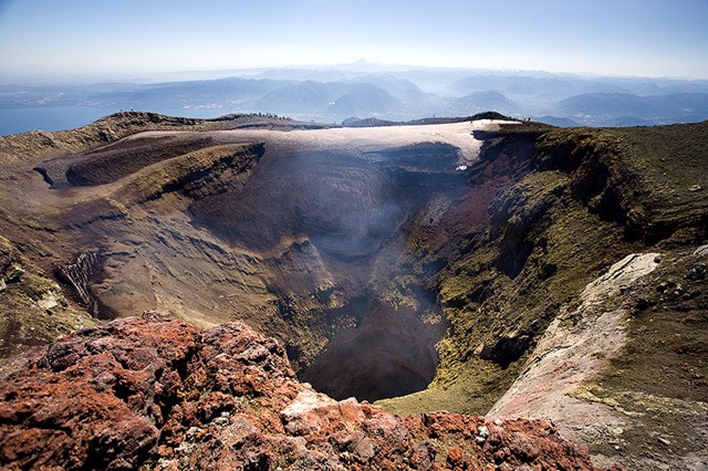 |
Figure 22. Photo of Villarrica's crater on 25 February 2009, with a diffuse gas plume rising from the central pit. Visitors can be seen on the far crater rim, where some snow is present. View is towards the NNE, with Llaima in the distance. Courtesy of Szymon Kochanski (Creative Commons license). |
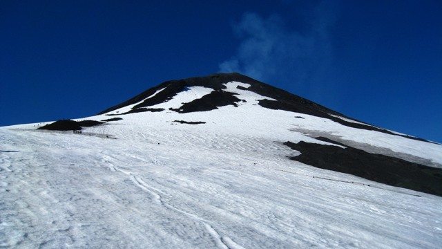 |
Figure 23. Photo showing the cone of Villarrica during an ascent on 8 March 2009. A very diffuse fumarolic plume is rising from the crater, which appears snow-free near the summit. Courtesy of James Byrum (Creative Commons license). |
Visitors in January 2010 recorded similar degassing conditions (figure 24) as that often seen in 2009. According to a January 2010 report by OVDAS, the only part of the crater that showed signs of heat without the presence of fresh snow was a fumarole on the SE margin of the crater. On 1 January 2010, the POVI webcam imaged a dark low-altitude plume. Incandescence was seen at night during January and February. According to the Buenos Aires Volcanic Ash Advisory Center, on 11 March a diffuse gas-and-ash plume drifted near the crater; ash was not detected on satellite imagery. OVDAS reported that, during an overflight, scientists saw a typical-looking gas plume drifting SW that day and tephra deposits on the flanks.
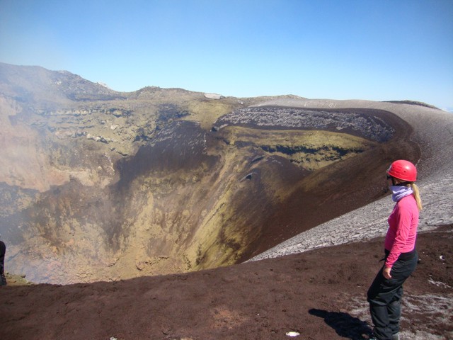 |
Figure 24. Photo of Villarrica's crater on 24 January 2010. A diffuse gas plume is rising from the crater (left). View is from the N crater rim. Courtesy of Liam and Hels (Creative Commons license). |
On 24 March, the webcam recorded steam emanating from the crater; the steam was caused by the heating and then condensation of snow from a recent storm. In April, seismic activity increased somewhat, accompanied by a rise in the lava lake level, more vigorous fumarolic activity, and more frequent incandescence at night. Strombolian activity was seen by climbers on the crater rim on 23 April (figure 25). Additional videos and photographs taken during 24-25 April, and 8 and 10 May (posted on the POVI website) showed continuing Strombolian activity in the crater. Bursts of lava did not rise above the crater rim, but gas plumes rose from the crater. The increased activity prompted OVDAS to increase the Alert Level from Green Level 1 to Green Level 2. According to POVI, on 10 May the spattering lava lake was about 100 m below the crater rim.
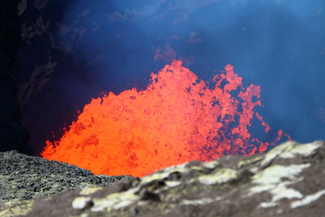 |
Figure 25. Photo of Strombolian activity in Villarrica's crater taken on 23 April 2010. Courtesy of elrentalplats (Creative Commons license). |
During 2009 thermal anomalies detected using MODIS/MODVOLC data occurred on 24 March, 9 April, and 26 November. An ASTER image also showed an anomaly on 8 March 2009. Detection of thermal anomalies continued in early 2010, with hot spots on 6 and 22 January, 10, 14, 16, and 23-26 February, and 11 March. Beginning on 5 April 2010, thermal anomalies became more frequent, with detections on 18 days in April, and 14 days in May.
Information Contacts: Observatorio Volcanológico de los Andes del Sur-Servico Nacional de Geologia y Mineria (OVDAS-SERNAGEOMIN) (Southern Andes Volcanological Observatory-National Geology and Mining Service), Avda Sta María No. 0104, Santiago, Chile (URL: http://www.sernageomin.cl/); Buenos Aires Volcanic Ash Advisory Center (VAAC), Servicio Meteorológico Nacional-Fuerza Aérea Argentina, 25 de mayo 658, Buenos Aires, Argentina (URL: http://www.smn.gov.ar/vaac/buenosaires/productos.php); Projecto Observación Visual Volcán Villarrica (POVI) (URL: http://www.povi.cl/villarrica.html); Oficina Nacional de Emergencia del Ministerio del Interior (ONEMI), Beauchef 1637 /1671, Santiago, Chile (URL: http://www.onemi.cl/); Flickr.com (Photographers: elrentaplats, http://www.flickr.com/photos/elrentaplats/); Liam and Hels, http://www.flickr.com/photos/liam-hels-big-trip/); Szymon Kochanski, http://www.flickr.com/photos/mywayaround/); James Byrum, http://www.flickr.com/photos/jimmybyrum/).
Nearly continuous gas plumes emitted from long-lived lava lake through October 2010
During April-October 2010, nearly continuous gas plumes from Villarrica (figures 26 and 27), sometimes containing small amounts of ash, occasionally rose higher than 700 m above the crater rim. Tremor occurred, as well as frequent incandescence at night. During that time, there were 118 thermal alerts derived from the Hawai'i Institute of Geophysics and Planetology Thermal Alerts System (MODVOLC). Activity through April 2010 consisted of steam emanating from the crater punctuated by periods of Strombolian activity from the lava lake, which has been observed in the majority of eruptions since 1996; however, bursts of lava did not rise above the crater rim (BGVN 35:04).
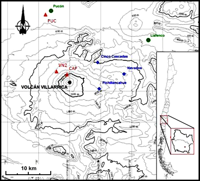 |
Figure 26. Map showing Chile (inset) and elevation contours around Villarrica (main map). Note the city of Pucón located 17 km NNW of the summit. Triangles designate seismic stations; circles represent web cameras; diamonds indicate Differential Optical Absorption Spectrometer (DOAS) stations. Courtesy of OVDAS-SERNAGEOMIN. |
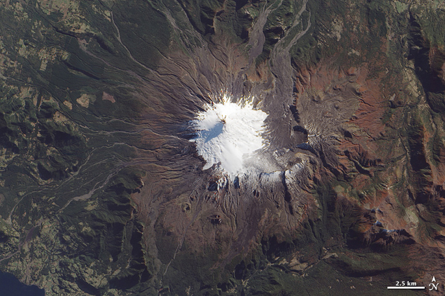 |
Figure 27. A NASA Earth Observatory image of Villarrica captured on 15 May 2010 by the EO-1 satellite. Courtesy of NASA Earth Observatory. |
During April, Observatorio Volcanológico de los Andes del Sur-Servico Nacional de Geologia y Mineria (OVDAS-SERNAGEOMIN) reported that the level of the lava lake rose slightly, gas emissions increased, and incandescence at night was more frequent. Seismicity also increased, with a total of 165 seismic events, of which 158 were tremors. The Alert Level was raised from "Green Level 1" to "Green Level 2" (out of a 3-color, 8-level scale). On 10 May, the surface of the spattering lava lake was ~100 m below the crater rim.
There was a slight increase in volcanic tremor through June, with a gradual decline after 26 June. Around this time, OVDAS-SERNAGEOMIN suggested that an unspecified decrease in the height of the lava lake was related to this decline in seismicity. From 9-22 July, tremor detected by the VN2 seismic station, 4 km NW of the summit, increased (figure 26). The events were located at depths of 6-10 km below the summit, except two that occurred 6 km S of the crater.
Throughout August 2010, most of the 485 seismic events recorded were long period; the largest of which was an M 2.1 located on the E edge of the caldera. During 13-15 August, slight increases in seismicity were correlated with increases in the shape and height of the steam plume emitted from the summit crater.
Seismicity decreased during September 2010, with a total of 161 seismic events recorded. On 4 September, a diffuse ash plume, possibly containing steam and gas, drifted NE. Seismicity increased significantly in October, totaling 1,874 long-period events. According to Projecto Observación Visual (POVI), ash plumes observed on 10 and 24 October and 1-2 November rose to altitudes of 3.7-4.6 km and drifted NE.
Information Contacts: Projecto Observación Visual (POVI) (URL: http://www.povi.cl/); Observatorio Volcanológico de los Andes del Sur-Servico Nacional de Geologia y Mineria (OVDAS-SERNAGEOMIN), Avda Sta María No. 0104, Santiago, Chile (URL: http://www.sernageomin.cl/); Hawai'i Institute of Geophysics and Planetology (HIGP) Thermal Alerts System, School of Ocean and Earth Science and Technology (SOEST), Univ. of Hawai'i, 2525 Correa Road, Honolulu, HI 96822, USA (URL: http://modis.higp.hawaii.edu/); Buenos Aires Volcanic Ash Advisory Center (VAAC), Servicio Meteorológico Nacional-Fuerza Aérea Argentina, 25 de mayo 658, Buenos Aires, Argentina (URL: http://www.smn.gov.ar/vaac/buenosaires/productos.php); Jesse Allen and Robert Simmon, NASA Earth Observatory (URL: http://earthobservatory.nasa.gov/).
During November 2010 to December 2013, lava lake persists but few explosions
The year 2014 marks the 3rd decade of largely non-explosive activity at Villarrica, historically one of the most active volcanoes in the Andes. Villarrica has been relatively quiet since our last report, which discussed events from April 2010 to October 2010 (BGVN 35:10). This report covers the time period from November 2010 to December 2013.
During this reporting period, comparative quiet prevailed. There were occasional cases reported of spattering lava, small white plumes, minor ash emissions (up to 50 m above the crater rim), and nighttime incandescence reflected off of the plumes according to Proyecto Observación Villarrica Internet (POVI) and Observatorio Volcanológico de los Andes del Sur (OVDAS-SERNAGEOMIN). Satellite thermal radiance during the reporting interval suggested often low radiance, with rare cases of high incandescence consistent with turbulence and fountaining in the deep, 40 m wide lava lake.
On 17 September 2011 remobilized tephra rose ~500 m above the crater, which according to POVI, was likely caused by a sudden impact when a snow cornice detached and fell into the crater. On 19 September 2011, a rapid rise in the level of the lava lake caused much of the snow and ice to melt, especially on the southern inner wall. Strombolian explosions from the crater were observed on 26 September 2011, and tephra deposits on the E edge of the crater were noted. On 27 September 2011 incandescence from the lava lake was reflected in the cloud cover above.
The period from November 2011 to March 2012 saw very little explosive activity. Two small ash emissions occurred on 7 March. Incandescence from the crater was observed from the town of Pucon (16 km N) during 7-8 March. During 7-9 March, lava spattering from the lava lake was observed for the first time that year. Four small ash emissions were observed during 13-14 March. On 20 March a large, white plume was visible above the crater. The observer postulated that due to the humid atmospheric conditions that day, the steam condensate in the visible plume remained conspicuous both to a height of 1,500 m above the crater as well as 20 km SW of the crater.
According to POVI, an ash plume rose 50 m above Villarrica on 19 April 2012. Incandescence from Villarrica's crater subsided in mid-April and was undetected by satellite and ground observations at least through 10 November 2012.
On 30 January 2013, weak incandescence was observed in the near-infrared spectrum from the ASTER (Advanced Spaceborne Thermal Emission and Reflection Radiometer) instrument on the Terra satellite. POVI reported that satellite images of Villarrica acquired on 25 July revealed a weak thermal anomaly. On 29 July 2013 observers photographed the crater and described a thermal anomaly on the S edge of the crater rim, in the same area from which a lava flow originated on 29 December 1971. They also heard deep degassing sounds. A second photograph showed a diffuse gas plume rising from the bottom of the crater, and ash and lapilli on the snow on the inner crater walls.
Analysis of MODIS (Moderate Resolution Imaging Spectroradiometer) band 21 (3.929-3.989 μm) satellite images from 2003 to 2013 highlights three main cycles of activity. These were characterized by convective lava fountains and Strombolian explosions from the lava pit, located ~ 40-150 m below the rim of the crater, according to POVI. The last time MODIS infrared sensors detected elevated thermal radiance was in early 2012 (figure 8).
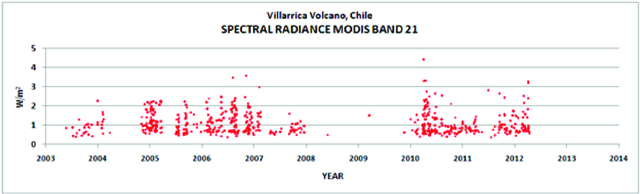 |
Figure 28. Elevated thermal radiance in Watts per square meter detected at Villarrica using MODIS band 21 (3.929-3.989 μm) from 2003 through 2013. Courtesy of POVI and NASA MODIS. |
In accord with the thermal radiance data seen in figure 28, OVDAS-SERNAGEOMIN maintained an Alert Level of Green for Villarrica from the period of 5 March 2012 to 30 December 2013, characterizing Villarrica as active but stable with no immediate threat. The seismicity reports from OVDAS-SERNAGEOMIN during the period of July 2013 to December 2013 showed the monthly number of earthquakes recorded ranged from 439 to 1,433. The reduced displacement of the tremors recorded fluctuated throughout July 2013- December 2013 from 0.6 cm² to 9.9 cm². During this period of time, the amount of SO2 emissions recorded by a scanning DOAS spectrometer OVDAS-SERNAGEOMIN varied from 156 tons/day to 888 tons/day. The height above the crater rim of the steam-gas plumes ranged from 150 m to 1,500 m. MODIS did not record any thermal anomalies during this period of time.
 |
Figure 29. Aerial image of the Villarrica crater at dawn on 14 October 2013. Copyrighted image taken by Diego Spatafore. |
Information Contacts: Proyecto Observación Villarrica Internet (POVI) (URL: http://www.povi.cl/); and Observatorio Volcanológico de los Andes del Sur Servicio Nacional de Geologia y Mineria (OVDAS SERNAGEOMIN), Santiago, Chile (URL: http://www2.sernageomin.cl/ovdas).
Lava lake reappears in February 2015 and is ongoing; large ash explosion on 3 March 2015
Villarrica is a stratovolcano located 675 km S of Santiago, Chile. Historical eruptions, documented since 1558, have consisted largely of mild-to-moderate explosive activity with occasional lava effusion. An intermittently visible lava lake with Strombolian activity was responsible for persistent MODIS thermal anomalies between November 2009 and April 2012. Very little additional activity was observed until December 2014, when renewed activity was reported by the Southern Andes Volcano Observatory, (Observatorio Volcanológico de Los Andes del Sur, OVDAS) part of Chile's National Service of Geology and Mining (Servicio Nacional de Geología y Minería, SERNAGEOMIN), and Projecto Observación Villarrica Internet (POVI), a privately funded research group that studies Villarrica.
Increased fumarolic and thermal activity was first observed in early December 2014 followed by Strombolian activity and ash emissions during 4-6 February 2015. A large explosion with an ash plume to 9 km altitude took place on 3 March 2015, and continued moderate explosive and Strombolian activity occurred a number of times during March. Explosive activity with ash plumes and lava spattering continued at decreasing levels throughout 2015; in 2016, minor ash emissions were only reported in September. Intermittent Strombolian activity at the lava lake occurred throughout 2015 and 2016 and was recorded as significant thermal anomalies through October 2016.
Activity during 2014. OVDAS reported that seismic activity in 2014 started the year very low with 604 total events in January. Steam plumes remained below 500 m above the summit throughout the year except for one report of heights to 800 m in February. Tremor displacements in 2014 remained in the range of 0.4 to 1.2 cm2 at frequencies of 1.1-1.2 Hz and amplitudes of 0.6-0.7 μm/s, all within background levels. Sulfur dioxide emission values ranged between 180 and 566 metric tons per day (t/d) as monthly averages, with maximum values not over 1,600 t/d throughout the year. The number of seismic events increased from 1,160 in April to 3,269 in May 2014, and took a larger jump between June and July from 4,268 to 11,031. The number of monthly seismic events remained in the 10,000-12,000 range through 2014, while the other parameters measured by OVDAS remained stable. There were no reported ash emissions.
As a privately funded research group, POVI documents activity at the volcano with webcams, photographs, and frequent summit ascents. They first observed increased sulfurous fumarolic activity on 25 November 2014. They also reported on NASA ASTER IR observations of a progressive increase in spectral brightness in satellite data on 10 and 26 November and 3 December. POVI observed the presence of particulate matter suspended over Villarrica on 9 December, and a light dusting of material within 1,000 m of the summit the following day. Increased acoustic activity of loud explosions of gases inside the 40-m-wide volcanic vent at the summit crater were reported during 10-12 December.
OVDAS reported on 18 December 2014 that the seismic energy had abruptly declined on 9 December. A flyover by the Oficina Nacional de Emergencia - Ministerio del Interior (ONEMI), the National Emergency Office of the Ministry of Interior and Public Safety, on 17 December was not able to observe the bottom of the crater due to weather conditions. In January 2015 seismic activity returned to previous levels and other measurements remained at background levels.
Activity during 2015. On 4 and 5 February 2015 POVI observed the first Strombolian eruptions inside of the summit crater vent since April 2012, and constant strong degassing occurring in 10 minute pulses. On 6 February they captured nighttime images of incandescent explosions rising to 65 m above the crater edge. Spatter fragments up to 40 cm were scattered around the summit. POVI also recorded two ash explosions on 6 February, and photographed 5 m diameter incandescent blocks on 7 February in the air 45 m above the crater.
A gradual increase in the amplitude of the seismic tremor signal was reported by OVDAS beginning on 6 February. The seismic signal rose from DR (Reduced Displacement) values of 4.0 cm2 to 24 cm2, and amplitudes increased to 18.5 μm/s, considered moderate to high for Villarrica and significantly above its background values of 2 cm2 and 1 μm/s. The location of the tremor signal was also shallower than it had been previously.
During the night of 9-10 February, POVI observed about 24 Strombolian explosions that rose above the crater rim and sent large blocks several meters down the NW flank. MODVOLC thermal anomalies pixels first reappeared on 14 February 2015. Between 14 and 16 February two active lava lakes were observed by POVI within the summit crater in nighttime imagery and during a flyover. OVDAS reported up to five explosions per minute at the summit crater on 16 February and continued nighttime incandescence since 6 February accompanied by intermittent ash emissions. Ejecta on 16 February was observed up to 1 km away on the S flank. Temperatures close to 800°C were measured that day near the lava lake surface on a flyover supported by ONEMI; tephra was observed around the crater rim and a thin layer of ash was distributed on the flanks. This caused SERNAGEOMIN to raise the alert level from Green to Yellow (1 to 2) on a 4-level scale.
A further increase in seismic energy release was reported by OVDAS on 28 February 2015 with DR values increased to 35 cm2, along with observations of nighttime incandescence and Strombolian explosions ejecting tephra up to 1 km from the crater. Two days later SERNAGEOMIN raised the alert level to Orange (3 of 4) based on increased DR values close to 80 cm2 and seismic amplitudes of 40 μm/s, as well as increased Strombolian activity and bombs ejected to 500-600 m from the crater.
An explosion early in the morning of 3 March 2015 with a 3-km-high ash plume, DR values near 400 cm2, and seismic amplitudes of 1,400 μm/s prompted SERNAGEOMIN to raise the alert level to Red (4 of 4) that morning. They reported observations from cameras around the volcano of a 1.5-km-tall lava fountain (figure 30). The Buenos Aires VAAC (Volcanic Ash Advisory Center) reported a plume to 9.1 km altitude drifting ESE later in the day. Significant ashfall was also visible around the flanks shortly after the explosion (figure 31).
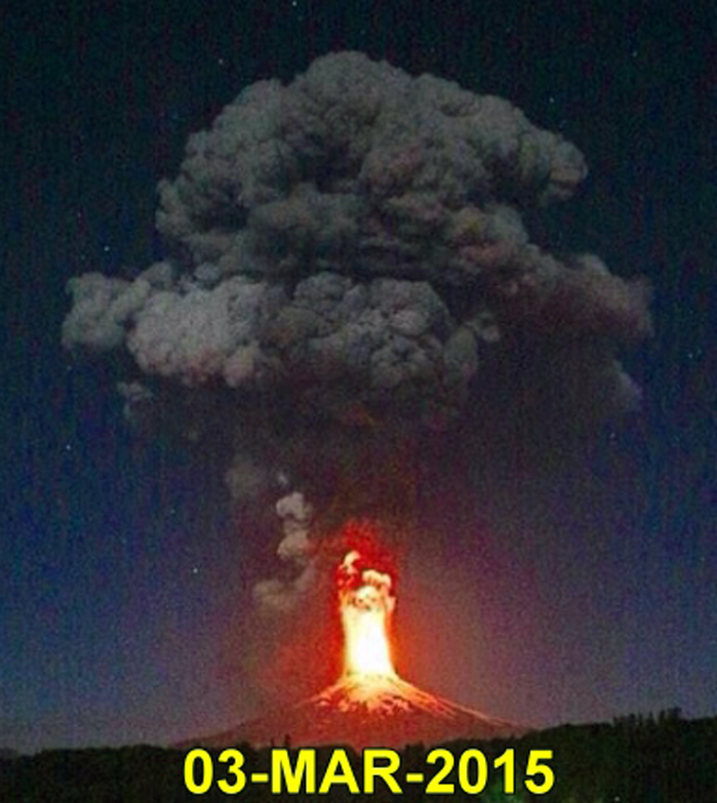 |
Figure 30. Explosive eruption at Villarrica on 3 March 2015, photographed from the city of Villarrica, 30 km NW of the volcano. The lava fountain was reported as 1.5 km tall. Courtesy of POVI. |
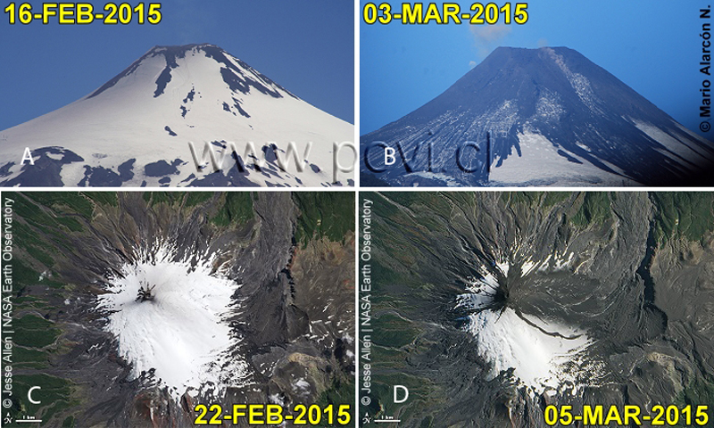 |
Figure 31. Ground-based webcam and satellite views of Villarrica before and after the 3 March 2015 eruption. The ash plume drifted E and spread ash on the glaciers around the N and E flanks of the volcano. The explosion sent ejecta radially outwards generating small lahars in drainages to the north and east. Images A and B courtesy of POVI (copyright by Mario Alarcon N.) from a camera located in Pucón, 17 km N. Images C and D annotated by POVI; courtesy of NASA Earth Observatory. |
The alert level was lowered back to Orange (3 of 4) on 6 March 2015 as activity decreased. During a flyover on 9 March, OVDAS scientists observed that the vent inside the crater was partially obstructed with debris, and fumarolic activity was weak. Minor debris avalanches had significantly decreased and the alert level was lowered to Yellow (2 of 4) on 10 March. A minor ash emission, under 100 m above the crater, occurred on 15 March. Two weak Strombolian explosions to 150 m above the crater were reported by OVDAS on 17 March. During 17-18 March, continued explosions with volcanic bombs, incandescence, and fine ash caused SERNAGEOMIN to raise the alert level back to Orange. POVI observed ash drifting E less than 70 m above the crater during this time.
The Buenos Aires VAAC reported water vapor and light ash emissions to 3 km beginning 22 March, drifting 45 km SE and continuing intermittently through 25 March. OVDAS reported sporadic incandescence throughout this time and intermittent ash plumes generally 100-500 m above the crater. POVI had also noted pulsating emissions of fine ash during 18-25 March. A significant increase in activity on 25 March led to a 700-m-high plume with high ash content, and visible incandescence. A flyover by OVDAS/ONEMI that day confirmed the presence of the lava lake near the surface again with temperatures around 1,000°C. The Buenos Aires VAAC reported a 5.5-km-high ash plume on 27 March extending 55 km NE. Plume heights exceeded 800 m on 28 March, with ejecta from the lava lake landing around the summit and upper flanks, and night incandescence. Strombolian explosions were observed for most of the night on 30 March. The highest explosion of spatter reached 300 m above the crater, and material fell 500 m away onto the flanks. That same day the Buenos Aires VAAC reported continuous ash emissions with a plume to 3.7 km drifting NE. On 31 March they reported irregular intermittent water vapor with small puffs of ash that were observed on the OVDAS web camera.
Strombolian activity fluctuated during April 2015. Pulsating emissions of water vapor were common. OVDAS reported ash plumes to 700 m above the summit crater on 4-5 and 20-21 April but otherwise periodic ash plumes were below 500 m. Buenos Aires VAAC reported the 5 April ash plume rising to 3.7 km altitude and drifting 16 km SSE. Ejecta occasionally reached 200 m from the crater. Nighttime incandescence from the crater was usually observed during clear weather, and seismicity generally decreased during the month. The lava lake and the formation of an incipient pyroclastic cone inside the inner crater were observed in an OVDAS/ONEMI flyover on 9 April; on a 21 April flight moderate Strombolian activity was viewed restricted to the interior of the crater.
During May 2015, OVDAS reported small Strombolian explosions from the lava lake, diffuse gas emissions with occasional ash, nighttime crater incandescence, and decreasing seismicity. Activity continued to gradually decline, and on 8 June the Alert Level was lowered to Yellow.
Sporadic incandescence was still observed during clear weather between June and September 2015, with plume heights below 450 m except for occasional plumes to 700 m above the summit crater. Two ash emissions were recorded on the OVDAS cameras on 18 and 21 September to heights less than 400 m. Plume heights in October were near 700 m, and another small ash emission was recorded on 31 October along with incandescence on clear nights. A group of OVDAS scientists conducted a field visit on 27 October and observed 11 new small fumaroles on the inner wall of the crater, and steep walls of pyroclastic material generated in the explosions from earlier in the year. They observed the lava lake in an overflight on 29 October and the temperature of the lake was measured at 850°C (figure 32). During the second week of November weak explosions were heard and pyroclastic material was observed above the crater rim; plume heights were close to 400 m, but rose to 700 m in December. A particulate emission that rose to 200 m above the crater occurred on 15 December. SERNAGEOMIN lowered the alert level to Green on 31 December 2015.
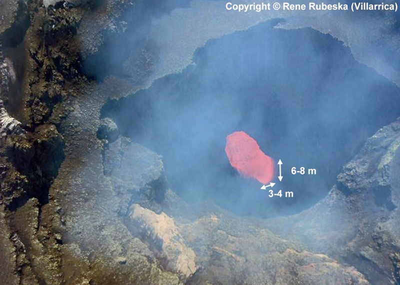 |
Figure 32. Lava lake at Villarrica on 31 October 2015. Oblique aerial image shows the crater, about 80 m deep, and dimensions of the lava lake. Image copyright by René Rubeska. Courtesy of POVI. |
Although ash emissions and Strombolian activity were intermittent and generally decreasing after June 2015, strong thermal anomalies seen in MODVOLC data continued throughout the year. February, March, July, August, October, and November each had between 5 and 10 days with thermal anomalies while April, May, June, September, and December all had between 10 and 15 days with MODVOLC alert pixels, indicating continued activity at the lava lake.
Activity during 2016. Water vapor plumes rose to 600 m above the crater in January and February 2016, along with slightly increased SO2 emissions and night incandescence. Small ash emissions on 6 and 29 February and the formation of a small pyroclastic cone inside the crater were observed by visiting scientists from the University of Cambridge. One VT (volcano-tectonic) earthquake of M 3.7, larger than normal, was reported by OVDAS on 26 March; it was located 4.7 km ESE of the crater at a depth of 4.2 km. This was followed by a spike in the number of VT events the following day. The amplitude and frequency values associated with seismic tremors remained within normal levels until a sudden but brief increase on 3 April that was associated with explosions and minor Strombolian activity at the lava lake within the crater. This activity resulted in SERNAGEOMIN raising the alert level to Yellow. The frequency of clusters of VT seismic events increased during the second week in April; most were located in a NW-SE trending belt about 10 km long near the crater vent. Water vapor plumes continued rising to around 600-700 m above the crater during April and May with no significant changes in incandescence. OVDAS reported small emissions of particulate material around the crater in April and on 4 May. The alert level was lowered back to Green on 16 May.
From May through July 2016, only water vapor plumes between 300 and 700 m above the summit were reported by OVDAS. August was quieter still with plumes rising to only 150 m. Seismicity increased slightly in September, plumes rose to 600 m, and on four days (5, 10, 19, 24) small emissions of ash were observed. Water vapor plumes remained below 700 m in October, 2016.
While significant explosive activity did not occur during the year through October 2016, the lava lake remained visible and active, causing thermal anomalies recorded by MODIS and measured by both the MODVOLC and MIROVA systems. MODVOLC recorded thermal anomalies between 5 and 10 times each month from January through April, between 1 and 4 times in May, July, and August, and again between 5 and 10 times in September and October. This variation is also reflected in the MIROVA Log Radiation Power graph for 2016 (figure 33).
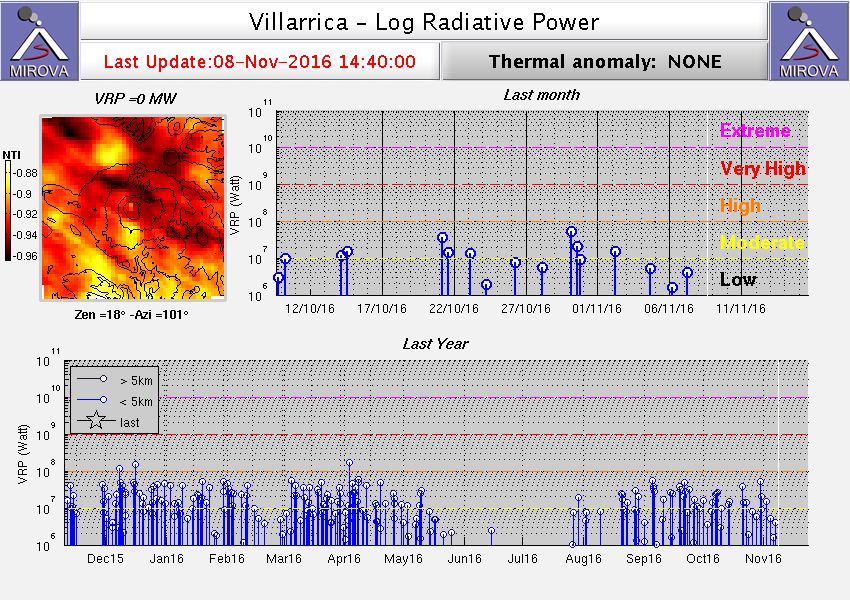 |
Figure 33. MIROVA system Log Radiative Power data for Villarrica between 8 November 2015 and 8 November 2016. The thermal anomalies were continuous and consistent except for a quiet period between late May and early August 2016. Courtesy of MIROVA. |
Information Contacts: Servicio Nacional de Geología y Minería, (SERNAGEOMIN), Observatorio Volcanológico de Los Andes del Sur (OVDAS), Avda Sta María No. 0104, Santiago, Chile (URL: http://www.sernageomin.cl/); Proyecto Observación Villarrica Internet (POVI) (URL: http://www.povi.cl/); Hawai'i Institute of Geophysics and Planetology (HIGP), MODVOLC Thermal Alerts System, School of Ocean and Earth Science and Technology (SOEST), Univ. of Hawai'i, 2525 Correa Road, Honolulu, HI 96822, USA (URL: http://modis.higp.hawaii.edu/, http://modis.higp.hawaii.edu/cgi-bin/modisnew.cgi); Oficina Nacional de Emergencia - Ministerio del Interior (ONEMI), Beaucheff 1637/1671, Santiago, Chile (URL: http://www.onemi.cl/); Buenos Aires Volcanic Ash Advisory Center (VAAC), Servicio Meteorológico Nacional-Fuerza Aérea Argentina, 25 de mayo 658, Buenos Aires, Argentina (URL: http://www.smn.gov.ar/vaac/buenosaires/inicio.php?lang=es); NASA Earth Observatory, EOS Project Science Office, NASA Goddard Space Flight Center, Goddard, Maryland, USA (URL: http://earthobservatory.nasa.gov/); MIROVA (Middle InfraRed Observation of Volcanic Activity), a collaborative project between the Universities of Turin and Florence (Italy) supported by the Centre for Volcanic Risk of the Italian Civil Protection Department (URL: http://www.mirovaweb.it/).
Lava lake level fluctuates and Strombolian activity persists during October 2016-November 2017
Historical eruptions at Chile's Villarrica (figure 34), documented since 1558, have consisted largely of mild-to-moderate explosive activity with occasional lava effusion. Lava flows emerging from the glacier-covered summit created deadly lahars in 1964 and 1971 (CSLP 95-71); a similar event in late 1984 led to evacuations and no fatalities occurred. Since then, an intermittently active lava lake has been the source of explosive activity, incandescence, and thermal anomalies. Renewed activity in early December 2014 was followed by a large explosion on 3 March 2015 that included a 9-km-altitude ash plume. Significant thermal anomalies from continued Strombolian activity at the lava lake and small ash emissions persisted through October 2016 (BGVN 41:11). Activity has continued during October 2016-November 2017, with information provided primarily by the Southern Andes Volcano Observatory, (Observatorio Volcanológico de Los Andes del Sur, OVDAS) part of Chile's National Service of Geology and Mining (Servicio Nacional de Geología y Minería, SERNAGEOMIN), and Projecto Observación Villarrica Internet (POVI), part of the Fundacion Volcanes de Chile, a research group that studies volcanoes across Chile.
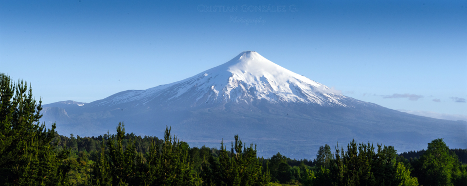 |
Figure 34. View of Villarrica from the town of Villarrica located 30 km NW on 10 November 2016. The active lava vent was also photographed the same day (see figure 40). Courtesy of Cristian Gonzalez G. |
Steam-and-gas emissions rising 200-1,000 m above the summit were observed throughout the period. The lava lake level inside the summit crater changed elevation by as much as 15 m during October 2016. Fluctuations of several meters up and down each month were reported through February 2017, and again in October 2017. Persistent minor gas-and-ash emissions, with small blocks and lapilli ejected onto the crater rim, were captured by the webcams and observed by visitors near the summit every month. Strombolian explosions and a "lava jet" sent ejecta more than 100 m above the crater rim during February 2017, and incandescent material rose 60 m above the crater rim on 1 July. Increased seismicity was detected during November 2017.
Activity during October-December 2016. Weak emissions of steam, gases, and volcanic ash near the summit were visible in the webcam during October 2016. The Buenos Aires Volcanic Ash Advisory Center (VAAC) noted a pilot report of an ash plume moving NNW on 20 October 2016 at 3.7 km altitude, slightly less than a kilometer above the summit. OVDAS reported that during the month, steam plumes rose less than 700 m and incandescence was visible at night when weather conditions permitted viewing of the summit. The MODVOLC thermal anomaly system issued 11 alerts during October. During several visits to the summit that month, POVI scientists observed that the lava lake had risen 15 m (figure 35) to a level that had been previously observed on 18 December 2015, 29 January, 28 March, and 18 September 2016. A small pyroclastic cone was visible inside the summit crater on 28 October (figure 36); by 30 October, most of it had collapsed and molten lava was again visible at the center (figure 37).
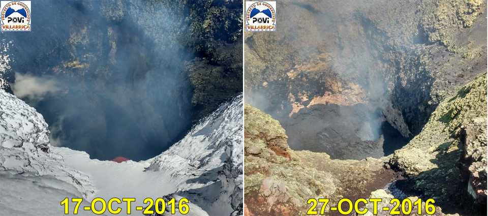 |
Figure 35. Between 17 and 27 October 2016, the lava lake rose about 15 meters inside the summit crater of Villarrica, reaching a similar level observed on 18 December 2015, 29 January, 28 March, and 18 September 2016. Courtesy of POVI (Volcán Villarrica, 27 de Octubre al 30 de Noviembre 2016). |
 |
Figure 36. A small pyroclastic cone is visible at the bottom of the summit crater at Villarrica on 28 October 2016 (red arrows). On the left slope sub-parallel annular fissures are visible (yellow arrows), indicating the imminent collapse of the nested structure. The white arrows point to residue precipitated from gas emissions. Courtesy of POVI (Volcán Villarrica, 27 de Octubre al 30 de Noviembre 2016). |
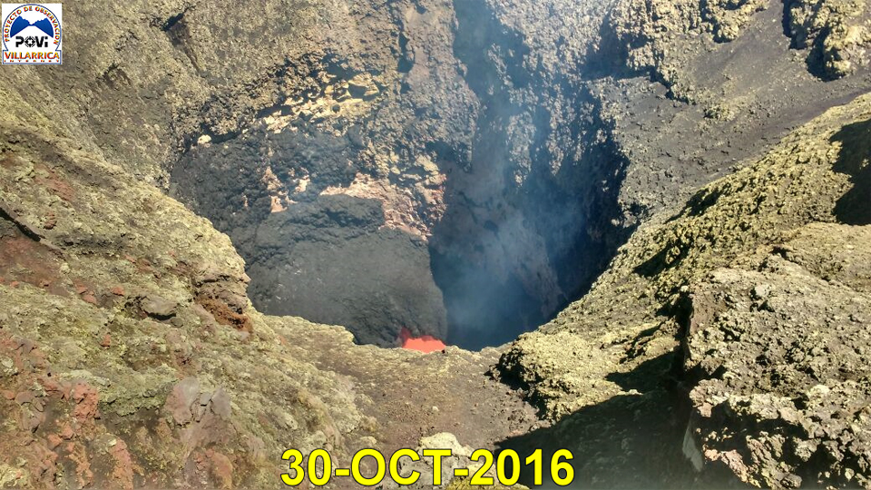 |
Figure 37. The nested cone visible on 28 October had collapsed by 30 October 2016 at Villarrica, and incandescent lava was visible inside the vent. Courtesy of POVI (Volcán Villarrica, 27 de Octubre al 30 de Noviembre 2016). |
During November and December 2016, steam emissions rose only 400 m above the crater and incandescence was only occasionally visible in the webcams at night. Thermal activity detected by satellite, however, was relatively high; MODVOLC issued twelve thermal alerts during November and nine during December. The repeated growth and destruction of small pyroclastic cones within the summit crater was well documented by several visits of POVI scientists to the summit (figures 38 and 40). They also collected bombs ejected near the crater rim (figure 39), and observed persistent minor ash-and-gas emissions (figure 41).
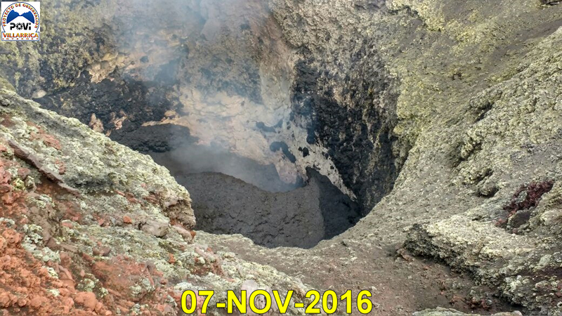 |
Figure 38. A new pyroclastic cone grows inside the summit crater of Villarrica on 7 November 2016, days after the collapse of the previous cone on 28 October. Black spatter from lava splashes stand out on the exposed slope. Courtesy of POVI (Volcán Villarrica, 27 de Octubre al 30 de Noviembre 2016). |
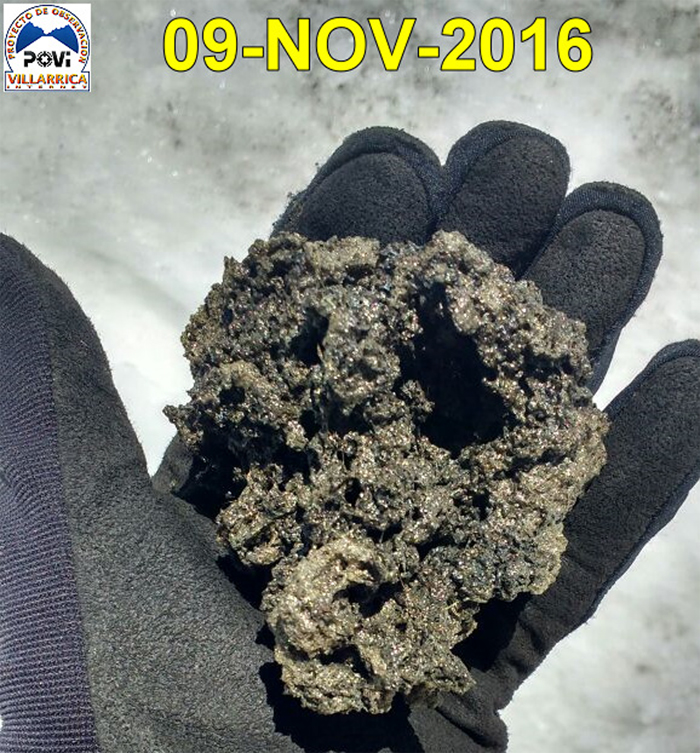 |
Figure 39. A piece of ejecta collected at the edges of the summit crater at Villarrica on 9 November 2016. Courtesy of POVI (Volcán Villarrica, 27 de Octubre al 30 de Noviembre 2016). |
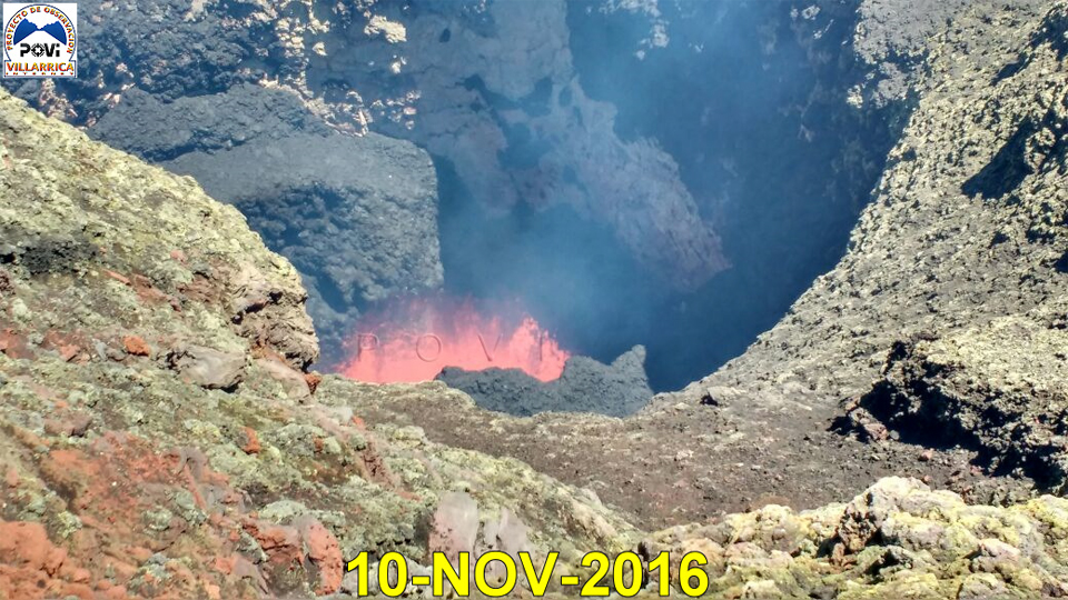 |
Figure 40. The pyroclastic cone at the summit crater of Villarrica photographed on 7 November had partially collapsed by 10 November 2016, the same day of the photograph showing a quiet, clear summit (figure 34). The splashes of lava rose no more than 10 m above the crater floor. Courtesy of POVI (Volcán Villarrica, 27 de Octubre al 30 de Noviembre 2016). |
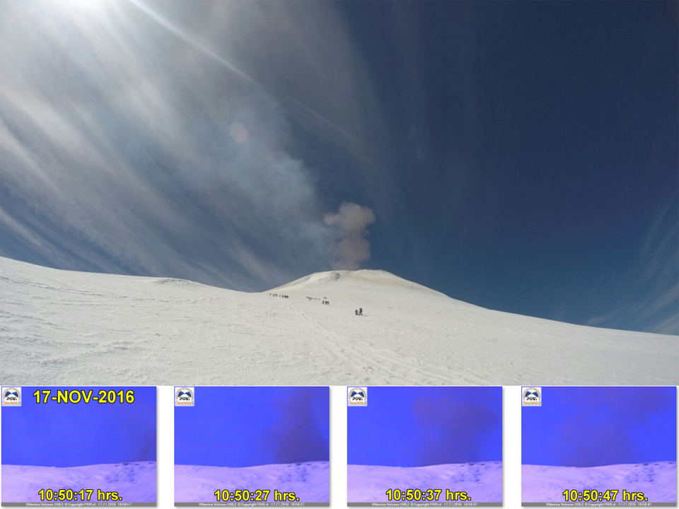 |
Figure 41. A small ash emission of rose from the summit of Villarrica on 17 November 2016 around 1050 local time. The larger image was taken by climbers, and the inset images are from the webcam. Courtesy of POVI (Volcán Villarrica, 27 de Octubre al 30 de Noviembre 2016). |
Observations by POVI scientists during December 2016 included continued evidence of cone creation and destruction in the vent (figure 42), and small lava fountains (figure 43). Strombolian explosions with bombs were recorded by the webcam on 1, 2, and 3 December. Bombs were ejected more than 50 m above the crater rim, some as large as 1.5 m in diameter. Between 2 and 3 December they observed an 8-10 m drop of the lava in the vent, leaving behind a circular depression with a small incandescent chimney on the NNW side. The webcam captured ash emissions on 2, 14, 15, 18, and 19 December.
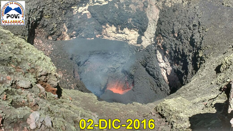 |
Figure 42. The partial collapse of the nested semicircular cone, reported by POVI on 30 November, was evident by 2 December 2016 inside the summit crater of Villarrica. The active vent is about 10-15 m in diameter. On the left wall of the crater the debris of a small recent landslide is visible above the lava. Courtesy of POVI (Informe Preliminar, Comportamiento del Volcán Villarrica, 01 al 31 de Diciembre 2016). |
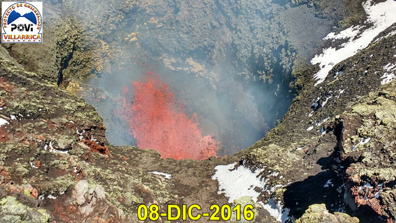 |
Figure 43. A small Strombolian explosion created a lava fountain inside the summit crater of Villarrica on 8 December 2016. Courtesy of POVI (Informe Preliminar, Comportamiento del Volcán Villarrica, 01 al 31 de Diciembre 2016). |
Activity during January-May 2017. OVDAS reported nighttime incandescence and steam emissions less than 250 m high during January 2017. They were higher in February, rising 700 m above the crater rim. Six MODVOLC thermal alerts were issued in January and one in February.
Volcanologists from POVI reported an increase in activity during February (figure 44), including a sudden collapse of about 10 m of much of the material in the lava pit on 9 February, after which a new rise began almost immediately (figure 45). During 10-15 February, explosions from a narrow vent sent lava fountains and ejecta more than 100 m high (figures 46). On 13 February, they witnessed powerful "lava jets" that rose 150 m (figure 47); bombs up to a meter in diameter were ejected 50 m from the vent and spatter covered much of the inner walls of the crater. Between 5 and 26 February, pyroclastic debris raised the level of the bottom of the crater by 10-12 m (figure 48).
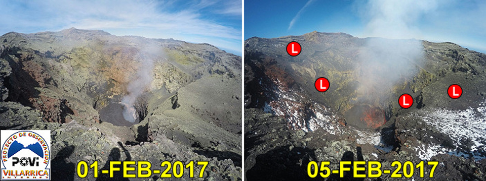 |
Figure 44. An increase in thermal and explosive activity was apparent between 1 and 5 February 2017 at the summit crater of Villarrica. Recently deposited lapilli (L) between 2-64 mm were scattered around the funnel shaped crater on 5 February (right). Courtesy of POVI (Volcán Villarrica, Seguimiento Científico de Actividad Volcanánica, 01 al 28 de Febrero 2017). |
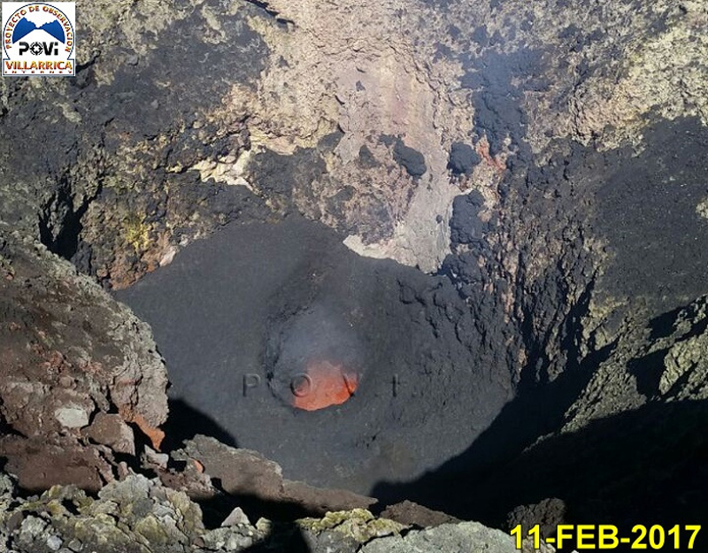 |
Figure 45. Fresh lava spattered on the inner wall of the summit crater at Villarrica on 11 February 2017, during a new rise in the magma level after a collapse two days earlier. The diameter of the active vent had increased significantly during the previous 24 hours. Courtesy of POVI (Volcán Villarrica, Seguimiento Científico de Actividad Volcanánica, 01 al 28 de Febrero 2017). |
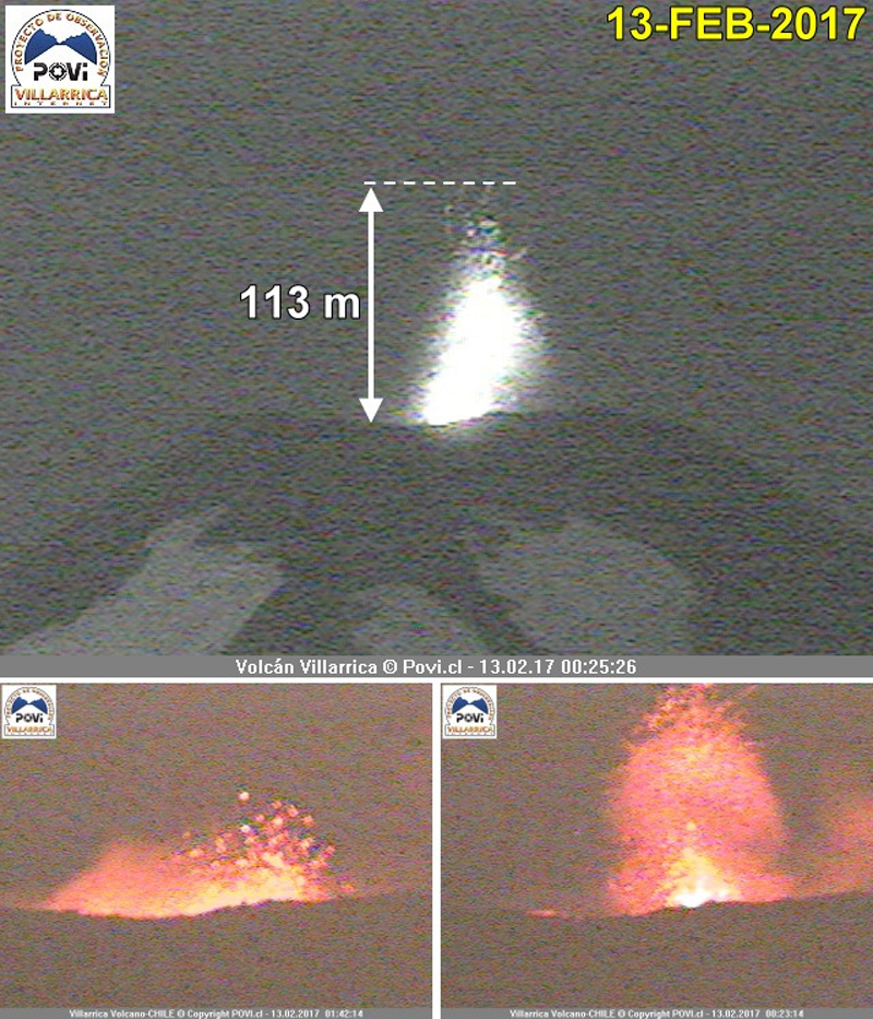 |
Figure 46. Lava fountains exceeded 100 meters above the crater rim at Villarrica on 13 February 2017. Images captured just after midnight show the first explosion (lower right) at 0023 local time, followed two minutes later by the upper image, and another explosion (lower left) about 20 minutes later. Courtesy of POVI (Volcán Villarrica, Seguimiento Científico de Actividad Volcanánica, 01 al 28 de Febrero 2017). |
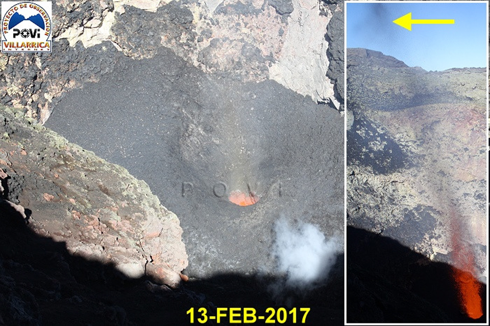 |
Figure 47. The active vent in the summit crater of Villarrica was about 7 m in diameter on 13 February 2017, and sporadically emitted powerful and noisy "lava jets" more than 150 m high. Courtesy of POVI (Volcán Villarrica, Seguimiento Científico de Actividad Volcanánica, 01 al 28 de Febrero 2017). |
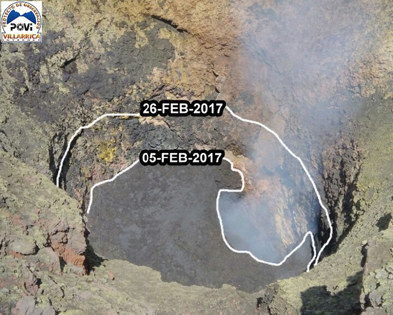 |
Figure 48. Between 5 and 26 February 2017, the level of the bottom of the summit crater at Villarrica rose by about 10-12 m. Courtesy of POVI (Volcán Villarrica, Seguimiento Científico de Actividad Volcanánica, 01 al 28 de Febrero 2017). |
During March 2017, OVDAS reported steam-and-gas emissions rising 1,000 m. They issued a special report on 23 March indicating an increase in the gas plume height and the occurrence of sporadic explosions of ballistic material that remained within the summit crater. Single MODVOLC thermal alerts were issued on 7 and 14 March 2017.
Nighttime incandescence and steam plumes rising to 550 m characterized activity reported by OVDAS during April 2017. Only a single MODVOLC thermal alert was issued on 4 April. Steam plumes were reported to only 250 m above the crater rim during May along with incandescence at night, but there were seven MODVOLC thermal alerts on four different days; 1 (2), 19 (3), 20, and 29 May.
Activity during June-November 2017. OVDAS reported low levels of activity during June 2017, with incandescence at night and steam plumes rising no higher than 170 m. Only a single MODVOLC thermal alert was issued on 20 June. On a visit to the summit crater on 5 June, POVI scientists observed a 10-m-diameter vent at the bottom of the crater, and lapilli fragments 2-64 mm in diameter distributed around the crater rim. A second visit on 19 June revealed increased explosive activity at the bottom of the crater, ash deposits on the inner walls of the crater, and more lapilli around the mouth of the crater (figure 49). POVI webcams recorded a significant increase in the intensity of incandescence from the summit crater on 24 June 2017 (figure 50).
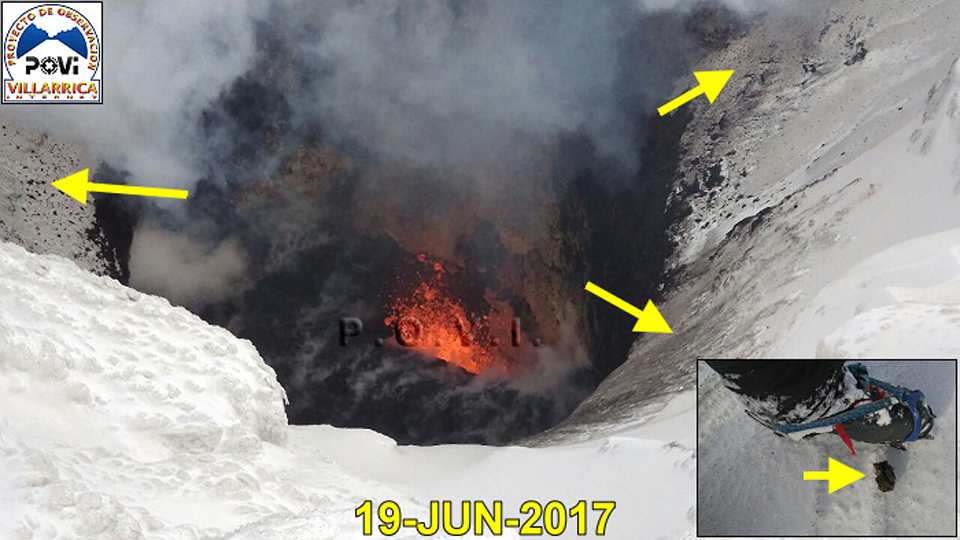 |
Figure 49. An increase in explosive activity with respect to that observed on 5 June was noted by POVI scientists on a visit to the summit crater of Villarrica on 19 June 2017. Fresh ash deposits and lapilli appeared on the snow around the crater rim (yellow arrows). Courtesy of POVI (Volcán Villarrica, Resumen del Comportamiento, Observado en Junio 2017). |
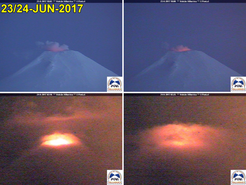 |
Figure 50. A significant increase in the intensity of the incandescence emitted from the summit crater at Villarrica was observed in the webcams during the night of 23-24 June 2017. The upper images show the incandescence in the early evening of 23 June, and the lower images were taken just after midnight on 24 June 2017 from the POVI webcam. Courtesy of POVI (Volcán Villarrica, Resumen del Comportamiento, Observado en Junio 2017). |
On 1 July 2017, POVI captured a webcam image of Strombolian explosions that sent incandescent material 60 m high from the summit crater. OVDAS reported steam plumes rising no more than 550 m and incandescence at night during July; there were no reported MODVOLC thermal alerts that month, and only a single alert on 30 August. OVDAS reported steam plumes during August rising to 150 m, sporadic ash and larger pyroclastic emissions around the crater rim, and nighttime incandescence.
Activity decreased during September and October 2017, with continued steam emissions rising 300-500 m, minor ash emissions around the crater rim, and nighttime incandescence. Two MODVOLC thermal alerts were issued, on 4 and 16 September, and none during October. POVI scientists visited the summit during October 2017 and noted that the vent remained active, especially after 22 October. They observed that at least half of the inner walls of the crater were covered with fresh ash and lapilli, concentrated on the W, S, and NE sides. They estimated that the active vent was about 8 m in diameter, approximately 100 m down inside the crater (figure 51). The bottom of the crater appeared about 4 m higher than it was on 26 September 2017, and the vent diameter had expanded by 2 m. Ash and lapilli fragments were found around the edge of the crater on 15, 22, and 25 October. Ejections of small fragments of lava were captured by the webcam on 22 and 23 October.
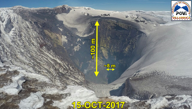 |
Figure 51. A panoramic image of the summit crater at Villarrica, looking S on 15 October 2017, showed pyroclastic material covering much of the inner surface of the crater wall. The vent was estimated to be about 8 m in diameter, at a depth of 100 m. Courtesy of POVI (Seguimiento y Estudio del Comportamiento, Volcán Villarrica, Octubre 2017). |
OVDAS reported that during November 2017, the webcams near the summit showed evidence of low intensity, predominantly white degassing to low altitudes (100 m above the summit). Nighttime incandescence associated with occasional explosions around the crater were typical. They also noted that long-period (LP) seismicity increased in both energy amplitude and frequency during the last few days of the month. A gradual increase in RSAM values began on 15 November with a continuous tremor signal. A 4.1 magnitude event was reported on 24 November located 2.6 km ESE of the summit at a depth of 1.8 km. A single MODVOLC thermal alert was reported on 28 November.
Seismicity and thermal anomalies. Seismicity at Villarrica during October 2016-November 2017 was relatively stable (figure 52), although it varied between about 2,500 and 6,500 events per month, with over 90% recorded as LP events, and only a few VT (volcano-tectonic) events. The highest frequency values occurred in May (5,749) and November 2017 (6,484).
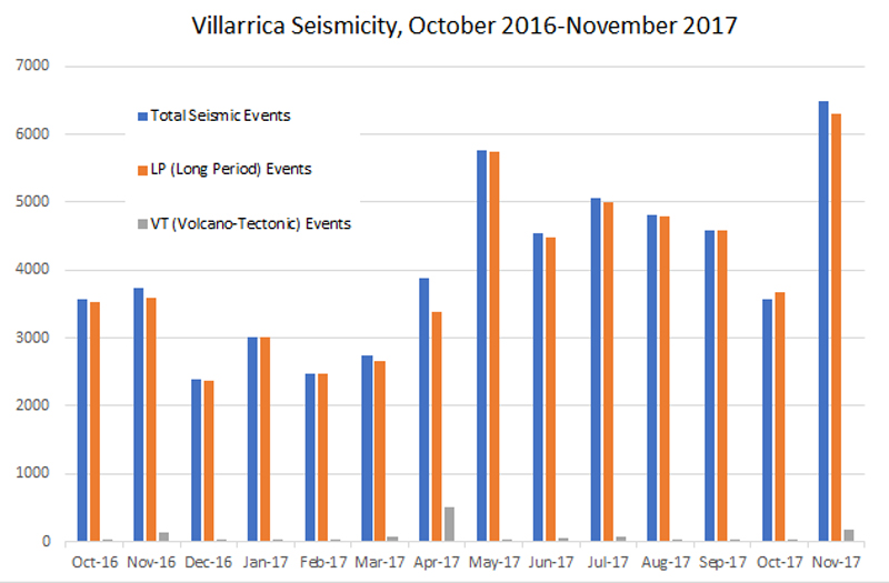 |
Figure 52. Chart of the frequency of seismic events at Villarrica, October 2016-November 2017. LP are Long-Period events, and VT are Volcano-Tectonic events. Data courtesy of OVDAS, SERNAGEOMIN monthly reports. |
Infrared data graphed by the MIROVA system (figure 53) indicated the continuous but decreasing frequency and intensity of thermal anomalies at Villarrica between November 2016 and November 2017.
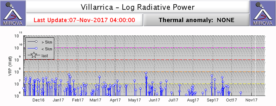 |
Figure 53. Infrared data graphed by the MIROVA system indicated the continuous but decreasing frequency and intensity of thermal anomalies at Villarrica between November 2016 and November 2017. Courtesy of MIROVA. |
Information Contacts: Servicio Nacional de Geología y Minería, (SERNAGEOMIN), Observatorio Volcanológico de Los Andes del Sur (OVDAS), Avda Sta María No. 0104, Santiago, Chile (URL: http://www.sernageomin.cl/); Proyecto Observación Villarrica Internet (POVI) (URL: http://www.povi.cl/); Hawai'i Institute of Geophysics and Planetology (HIGP), MODVOLC Thermal Alerts System, School of Ocean and Earth Science and Technology (SOEST), Univ. of Hawai'i, 2525 Correa Road, Honolulu, HI 96822, USA (URL: http://hotspot.higp.hawaii.edu/; http://modis.higp.hawaii.edu/); Buenos Aires Volcanic Ash Advisory Center (VAAC), Servicio Meteorológico Nacional-Fuerza Aérea Argentina, 25 de mayo 658, Buenos Aires, Argentina (URL: http://www.smn.gov.ar/vaac/buenosaires/inicio.php?lang=es); MIROVA (Middle InfraRed Observation of Volcanic Activity), a collaborative project between the Universities of Turin and Florence (Italy) supported by the Centre for Volcanic Risk of the Italian Civil Protection Department (URL: http://www.mirovaweb.it/); Cristian Gonzalez G., flickr (URL:https://www.flickr.com/photos/cg_fotografia/), photo used under Creative Commons license (https://creativecommons.org/licenses/by-nd/2.0/).
Thermal activity increases November-December 2017 and July-August 2018; intermittent incandescence and ash
Historical eruptions at Chile's Villarrica, documented since 1558, have consisted largely of mild-to-moderate explosive activity with occasional lava effusion. An intermittently active lava lake at the summit has been the source of explosive activity, incandescence, and thermal anomalies for several decades. A large explosion on 3 March 2015 included a 9-km-altitude ash plume; significant thermal anomalies from intermittent Strombolian activity at the lava lake and small ash emissions have continued since that time. Sporadic but reduced activity during November 2017-August 2018 is covered in this report, with information provided primarily by the Southern Andes Volcano Observatory (Observatorio Volcanológico de Los Andes del Sur, OVDAS), part of Chile's National Service of Geology and Mining (Servicio Nacional de Geología y Minería, SERNAGEOMIN), and Projecto Observación Villarrica Internet (POVI), part of the Fundacion Volcanes de Chile, a research group that studies volcanoes across Chile.
Seismicity increased during the second half of November 2017, along with observations of increased incandescence at night from occasional explosions inside the summit crater. Satellite instruments measured a brief surge of thermal activity from late November through early December. The next episode of increased activity occurred in the second half of February 2018 with minor satellite thermal data and webcam views of incandescence. A slow but sustained increase in energy was recorded during March 2018; sporadic incandescence was reported a few times each month between March and May, but observations indicated that the lava lake level was over 100 m below the crater rim. Satellite and webcam observations of incandescence increased in frequency and intensity during June; sporadic ash emissions were noted during mid- and late July. Continuous incandescence was observed in webcams during August 2018; satellite thermal data identified an abrupt rise in thermal energy in late July that remained at a low level into early September 2018.
Activity during November 2017-January 2018. OVDAS reported that during November 2017, the webcams near the summit showed evidence of low-intensity, predominantly white degassing to low altitudes (100 m above the summit). Nighttime incandescence associated with occasional explosions inside the crater were typical. They also noted that long-period (LP) seismicity increased in both energy amplitude and frequency during the last few days of the month. A gradual increase in RSAM values began on 15 November with a continuous tremor signal. A magnitude 4.1 event occurred on 24 November located 2.6 km ESE of the summit at a depth of 1.8 km. A single MODVOLC thermal alert was reported on 28 November. According to POVI the lava lake on the crater floor subsided 8 m between 10 and 20 November (figure 54); during the second half of the month they documented 50-m-high lava fountains, spatter on the crater rim, incandescent jets, and fresh ashfall on the snow cover around the crater rim (figures 55 and 56).
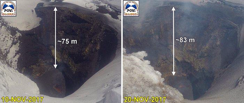 |
Figure 54. The SW part of the crater floor at Villarrica subsided about 8 m between 10 and 20 November 2017. Courtesy of POVI (Volcán Villarrica, Resumen Gráfico del Comportamiento, November 2017 a Febrero 2019). |
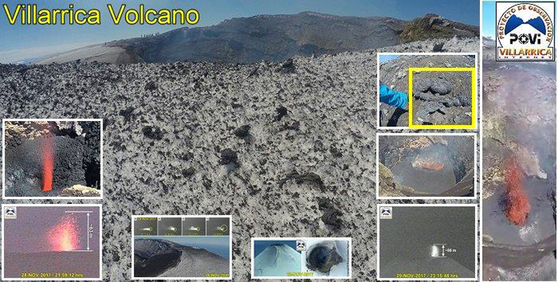 |
Figure 55. During the second half of November 2017, POVI documented 50 m high lava fountains, spatter on the crater rim, incandescent jets, and fresh ashfall on the snow cover around the crater rim at Villarrica. Courtesy of POVI (Volcán Villarrica, Resumen Gráfico del Comportamiento, November 2017 a Febrero 2019). |
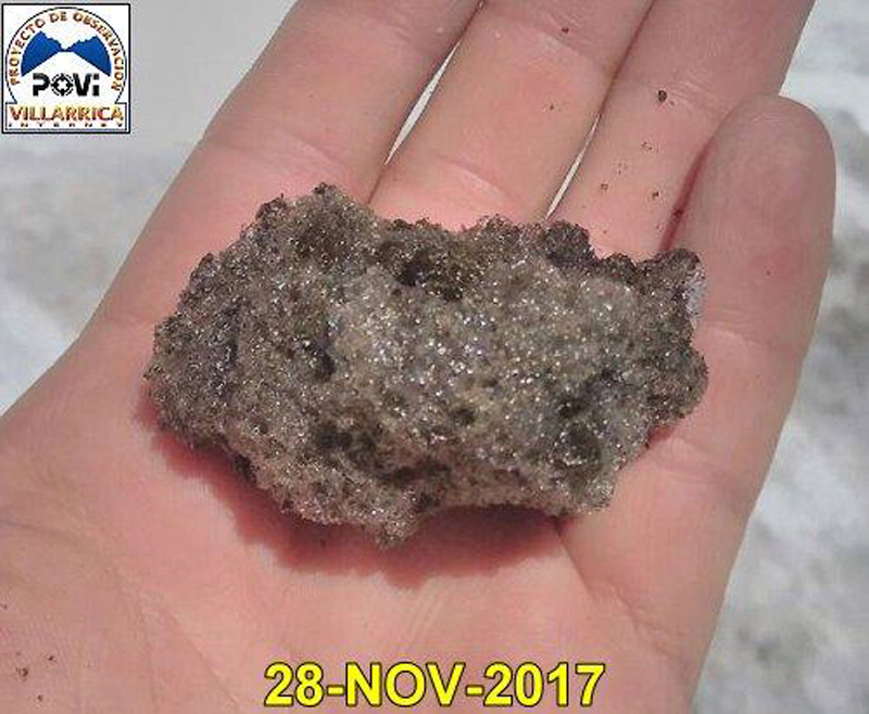 |
Figure 56. A sample of reticulite or basaltic pumice collected on 28 November 2017 from the summit of Villarrica. It is a highly vesiculated scoria, with greater than 98% porosity. Courtesy of POVI (Volcán Villarrica, Resumen Gráfico del Comportamiento, November 2017 a Febrero 2019). |
On 5 December 2017, SERNAGEOMIN raised the Alert Level at Villarrica from Green to Yellow (on a 4-level scale), noting a progressive increase in seismic and thermal energy since 15 November. They increased the restricted radius from 500 to 1,000 m from the summit crater. SERNAGEOMIN reported low-intensity degassing during the first half of December 2017, mostly white, and rising not more than 650 m above the crater. Incandescence was visible on clear nights, with occasional explosions that remained below the crater rim. They reported that increased surficial activity was visible during the first few days of December, followed by a decrease in activity (figure 57). POVI images at the end of December (figure 58) showed that the lake level had dropped more than 45 m between 5 and 27 December 2017. Seismicity also decreased throughout the month, reaching its lowest level of the year at the end of December.
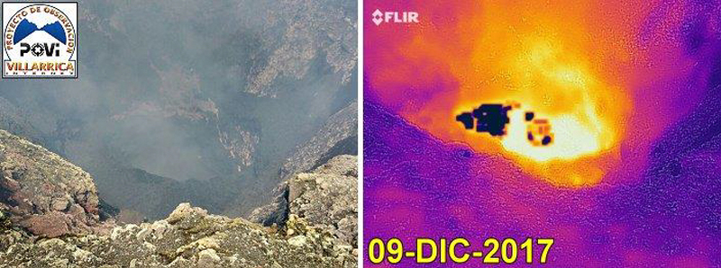 |
Figure 57. POVI reported that on 9 December 2017 at Villarrica the level of the lake at the bottom of the crater was stable at about 70 m below the rim, and five days had passed with no observations of lava ejecta in the webcams. Images by Víctor Marfull, courtesy of POVI (Volcán Villarrica, Resumen Gráfico del Comportamiento, November 2017 a Febrero 2019). |
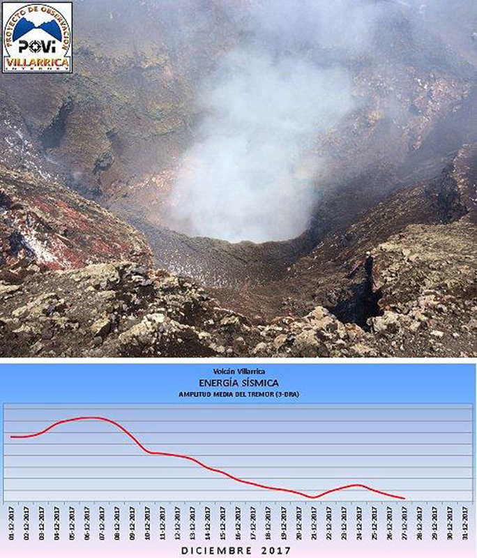 |
Figure 58. The lava lake at Villarrica subsided more than 45 m between 5 and 27 December 2017 when this image was taken. Seismic activity also decreased significantly throughout December, reaching its lowest level of the year. Courtesy of POVI (Volcán Villarrica, Resumen Gráfico del Comportamiento, November 2017 a Febrero 2019). |
On 6 January 2018 SERNAGEOMIN lowered the Alert Level to Green, noting a reduced thermal signal, low-level white degassing rising less than 300 m above the crater, and only occasional nighttime incandescence associated with explosions below the crater rim during the second half of December. POVI noted that the drop in seismicity at the end of December corresponded to the end of a 17-month-long period of increased seismicity (figure 59).
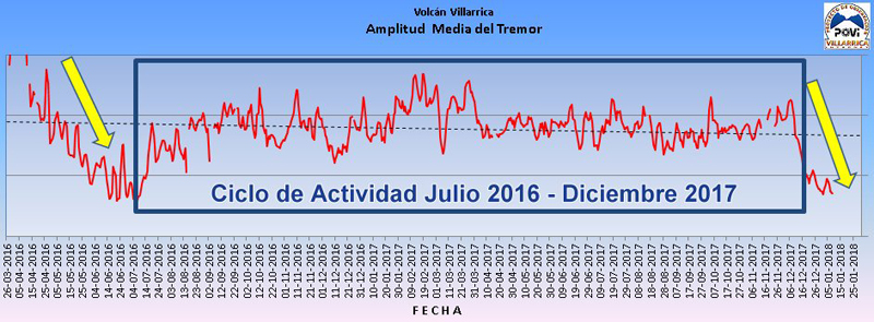 |
Figure 59. The drop in seismicity at the end of December 2017 suggested the end to a 17-month-long period of increased seismicity that began in July 2016 after a similar decrease in activity at the end of June 2016. Courtesy of POVI (Volcán Villarrica, Resumen Gráfico del Comportamiento, November 2017 a Febrero 2019). |
Activity during February-August 2018. Activity remained low at Villarrica during January 2018. Steam plumes rose less than 550 m above the crater and no thermal activity was apparent. After about six weeks of low activity, Sentinel-2 images indicated an increase in thermal activity between 5 and 18 February 2018 (figure 60). The Villarrica webcam also recorded incandescence at the summit for the first time in two months on 25 February 2018.
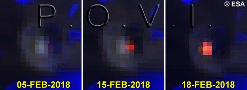 |
Figure 60. After about six weeks of low activity at Villarrica, Sentinel-2 images indicated an increase in thermal activity between 5 and 18 February 2018. Courtesy of POVI (Volcán Villarrica, Resumen Gráfico del Comportamiento, November 2017 a Febrero 2019). |
While SERNAGEOMIN reported only white degassing to less than 50 m above the summit in March 2018, POVI noted that seismic instruments recorded a slow but sustained increase in released energy. The lava lake was not visible and remained more than 110 m below the crater rim; a small spatter event was detected by a webcam on 7 March 2018 (figure 61). Sporadic incandescence, including on 13 and 20 March, was captured with a webcam located in Pucón, about 16 km N of the summit.
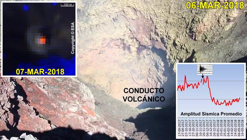 |
Figure 61. The surface of the lava lake at the summit of Villarrica remained more than 110 m below the crater rim on 6 March 2018. A small spatter of lava was detected by one of the POVI cameras on 7 March 2018, but little other activity was recorded. A slow but sustained increase in seismic energy was evident in the seismic amplitude data (inset). Courtesy of POVI (Volcán Villarrica, Resumen Gráfico del Comportamiento, November 2017 a Febrero 2019). |
A research effort in mid-March 2018 by Liu et al. (2019) to capture gas emissions close to the vent using Unmanned Aerial Systems (UAS) demonstrated good agreement between gas ratios obtained from simultaneous UAS- and ground-based multi-GAS acquisitions. The UAS measurements, however, taken from the young, less diluted gas plume revealed additional short-term patterns that reflected active degassing through discrete, audible gas exhalations (figures 62 and 63).
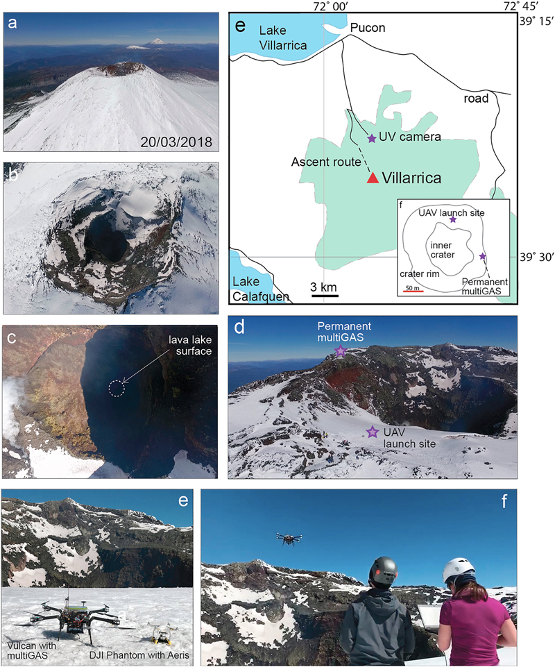 |
Figure 62. A research expedition to Villarrica on 20 and 21 March 2018 demonstrated the effectiveness of Unmanned Aerial Systems (UAS) in measuring gas emissions close to an active vent. a) This view to the SE shows Lanin and Quetrapillan volcanoes in the distance behind the summit of Villarrica. (b, c) The lava level was extremely low in the conduit during the measurement campaign, with the lake surface only visible as several pixels in aerial imagery. (d) Unmanned Aerial Systems (UAS) were launched from a sheltered plateau on the N rim of the crater, with the multi-GAS station visible on the eastern rim. (e, top right) Location map of the region, showing the position of UV camera. The green shaded region delimits the extent of the national park. Inset: Aerial map of the summit region shown in (d); the summit crater is ~200 m in diameter. (e, bottom left) Two instrumented multi-rotor vehicles were used in the campaign, the Vulcan octocopter with multi-GAS (left) and DJI Phantom 3 Pro with Aeris gas sensor (right). (f) Vulcan UAS in flight on 20 March 2018. UAV = Unmanned Aerial Vehicle. Taken from Figure 1 of Liu et al. (2019). |
 |
Figure 63. A comparison between contemporaneous proximal UAV and crater rim SO2 measurements at Villarrica. (a) The same-scaled axis highlights the magnitude of plume dilution between the proximal measurements from the UAV made directly above the conduit and those made at the crater rim only 100 m downwind. (b) When the time series are displayed on individually scaled axes it is apparent that even considering the temporal offset imposed by the downwind travel time, the periodic component of the proximal UAV trace is indistinguishable in the crater rim data. Taken from Figure 6 of Liu et al. (2019). |
A minor collapse of the crater wall caused a small plume of ash that rose a short distance above the summit on 29 March 2018. POVI's time-lapse webcams located in Pucón captured the event. Overnight on 1-2 April, sporadic incandescence was observed in the webcams and in Sentinel-2 satellite imagery. SERNAGEOMIN reported a single MIROVA alert signal on 13 April and an abrupt fall of the seismic signal on 27 April. The POVI webcam captured the brightest incandescence since mid-December 2017 on 3 May 2018. SERNAGEOMIN reported incandescence at the summit again on 23 May, and two thermal alerts on 22 and 25 May 2018.
While gas emissions remained less than 150 m above the summit during June 2018, observations of incandescence at night increased and were reported on 14, 18, 24, and 28 June, and were accompanied by satellite thermal signals on 14 and 24 June. Sporadic ash emissions that reached 400 m above the summit were reported by SERNAGEOMIN during July. The POVI webcam in Pucón captured an ash emission on 16 July 2018 that left ash and pyroclastic debris around the crater rim (figures 64 and 65). A second emission was recorded on 18 July;the Sentinel-2 satellite recorded the largest summit thermal signature since 10 December 2017 the same day.
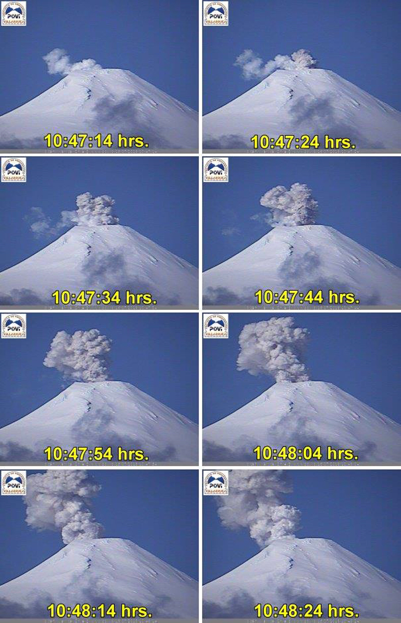 |
Figure 64. A steam and ash emission at Villarrica on 16 July 2018 was captured by the POVI webcam. Courtesy of POVI (Volcán Villarrica, Resumen Gráfico del Comportamiento, November 2017 a Febrero 2019). |
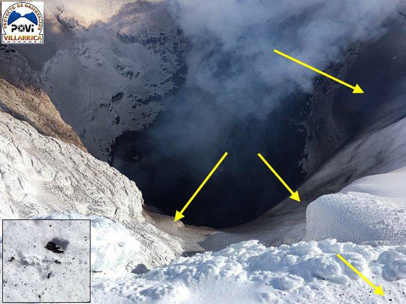 |
Figure 65. Ash and pyroclastic debris were deposited around the inside rim of the crater at Villarrica on 16 July 2018. Courtesy of POVI (Volcán Villarrica, Resumen Gráfico del Comportamiento, November 2017 a Febrero 2019). |
Activity continued to increase during July 2018; POVI photographed significant incandescence at the summit on 19 July and again on 25, 29, and 30 July after a period of cloudy weather. ESA's Sentinel-2 camera measured the largest heat area on the summit since August 2015 on 30 July (figure 66). As a result, the interior of the crater lost much of its snow cover and ice (figure 67). Ash and lapilli were visible in satellite imagery on the eastern edges of the crater.
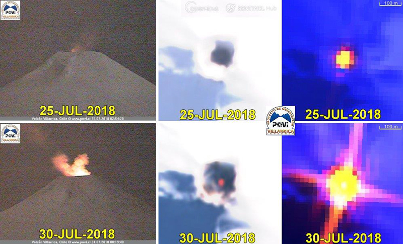 |
Figure 66. On July 30 2018 ESA's Copernicus program satellite, Sentinel-2, measured the largest heat area on the summit of Villarrica since August 2015. Due to the heat, the interior of the crater had lost much of its snow cover and ice. Ash and lapilli stand out on the eastern edges of the crater. Left: terrestrial images (objective 120 mm, 0.0001 lux), center: Sentinel-2, filters bands 8, 4 and 3; Right: Sentinel-2, filters bands 12, 11 and 4. Courtesy of POVI (Volcán Villarrica, Resumen Gráfico del Comportamiento, November 2017 a Febrero 2019). |
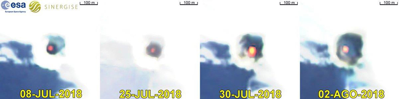 |
Figure 67. Sequential images of the Sentinel-2 satellite (ESA), with filters of bands 8, 4, and 3, illustrate the evolution of the heat surface emitted by the lava pit, and the decrease in snow and ice within and around the crater rim between 8 July and 2 August 2018. Courtesy of POVI (Volcán Villarrica, Resumen Gráfico del Comportamiento, November 2017 a Febrero 2019). |
SERNAGEOMIN reported continuous incandescence at the summit during August nights when the weather was clear. POVI noted on 31 August 2018 that the lake level had not changed during the month and was about 75 m below the inner W rim of the crater. The lake level remained unchanged during the first 10 days of September 2018 as well (figure 68).
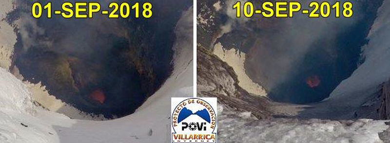 |
Figure 68. The lava lake level at the bottom of the summit crater of Villarrica was unchanged during the first 10 days of September 2018. Courtesy of POVI (Volcán Villarrica, Resumen Gráfico del Comportamiento, November 2017 a Febrero 2019). |
The thermal signature in the MIROVA graph for the period from October 2017 through August 2018 showed two clear increases in thermal energy between late November and mid-December 2017, and again from mid-June through August 2018 (figure 69). These corresponded well with MODVOLC thermal alert data which recorded one alert on 28 November 2017, 10 alerts during 2-11 December 2017, and five alerts between 30 July and 2 August 2018.
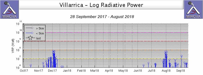 |
Figure 69. MIROVA thermal anomaly graph of log radiative power at Villarrica from 28 September 2017 through August 2018 shows two clear increases in activity, one in mid-November through mid-December 2017 and a second longer-lived phase that began in June 2018, peaked in late July-early August, and remained steady throughout the month of August. Courtesy of MIROVA. |
Reference: Liu, E. J., Wood, K., Mason, E., Edmonds, M., Aiuppa, A., Giudice, G., Bitetto, M., Francofonte, V., Burrow, S., Richardson, T., Watson, M., Pering, T.D., Wilkes, T.C., McGonigle, A.J.S., Velasquez, G., Melgarejo, C., and Bucarey, C., 2019. Dynamics of outgassing and plume transport revealed by proximal unmanned aerial system (UAS) measurements at Volcán Villarrica, Chile. Geochemistry, Geophysics, Geosystems, 20. https://doi.org/10.1029/2018GC007692
Information Contacts: Servicio Nacional de Geología y Minería (SERNAGEOMIN), Observatorio Volcanológico de Los Andes del Sur (OVDAS), Avda Sta María No. 0104, Santiago, Chile (URL: http://www.sernageomin.cl/); Proyecto Observación Villarrica Internet (POVI) (URL: http://www.povi.cl/); MIROVA (Middle InfraRed Observation of Volcanic Activity), a collaborative project between the Universities of Turin and Florence (Italy) supported by the Centre for Volcanic Risk of the Italian Civil Protection Department (URL: http://www.mirovaweb.it/); Hawai'i Institute of Geophysics and Planetology (HIGP) - MODVOLC Thermal Alerts System, School of Ocean and Earth Science and Technology (SOEST), Univ. of Hawai'i, 2525 Correa Road, Honolulu, HI 96822, USA (URL: http://modis.higp.hawaii.edu/).
Intermittent Strombolian activity ejects incandescent bombs around crater rim, September 2018-February 2019
Historical eruptions at Chile's Villarrica, documented since 1558, have consisted largely of mild-to-moderate explosive activity with occasional lava effusion. An intermittently active lava lake at the summit has been the source of explosive activity, incandescence, and thermal anomalies for several decades. Sporadic Strombolian activity at the lava lake and small ash emissions have continued since the last large explosion on 3 March 2015. Similar continuing activity during September 2018-February 2019 is covered in this report, with information provided primarily by the Southern Andes Volcano Observatory (Observatorio Volcanológico de Los Andes del Sur, OVDAS), part of Chile's National Service of Geology and Mining (Servicio Nacional de Geología y Minería, SERNAGEOMIN), and Projecto Observación Villarrica Internet (POVI), part of the Fundacion Volcanes de Chile, a research group that studies volcanoes across Chile.
After ash emissions during July 2018 and an increase in of thermal activity from late July through early September 2018 (BGVN 43:10), Villarrica was much quieter through February 2019. Steam plumes rose no more than a few hundred meters above the summit and the number of thermal alerts decreased steadily. Intermittent Strombolian activity sent ejecta a few tens of meters above the summit crater, with larger bombs landing outside the crater rim. A small pyroclastic cone appeared at the surface of the lava lake, about 70 m below the rim, in November. The largest lava fountain rose 35 m above the crater rim in late January 2019.
Steam plumes rose no more than 300 m above the crater during September 2018 and were less than 150 m high in October; incandescence at the summit was visible during clear nights, although a gradual decrease in activity suggested a lowering of the lake level to SERNAGEOMIN. SERNAGEOMIN attributed an increase in LP seismic events from 1,503 in September to 5,279 in October to dynamics of the lava lake inside the summit crater; counts decreased gradually in the following months.
POVI reported webcam evidence of Strombolian activity with ejecta around the crater several times during November 2018. On 5 November the webcam captured an image of an incandescent bomb, more than a meter in diameter, that landed on the NW flank. The next day, explosions sent ejecta 50 m above the edge of the crater, and pyroclastic debris landed around the perimeter. Significant Strombolian explosions on 16 November sent incandescent bombs toward the W rim of the crater (figure 70). The POVI webcam in Pucón captured incandescent ejecta landing on the crater rim on 23 November. POVI scientists observed a small pyroclastic cone, about 10-12 m in diameter, at the bottom of the summit crater on 19 November (figure 71); it was still visible on 25 November.
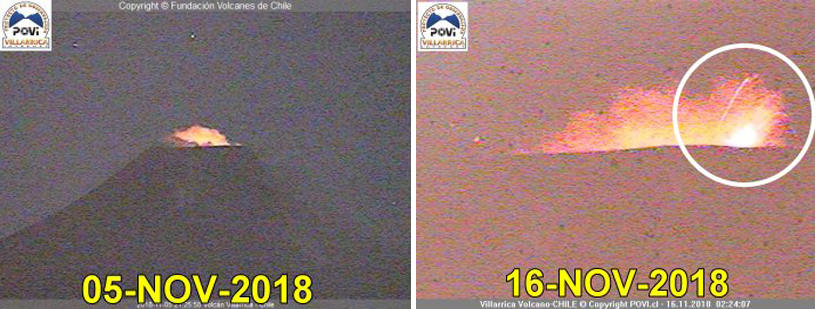 |
Figure 70. Strombolian activity at the summit of Villarrica was captured several times in the POVI webcam located in Pucón. An explosion on 5 November 2018 ejected a meter-sized bomb onto the NW flank (left). On 16 November, incandescent bombs were thrown outside the W rim of the crater (right). Courtesy of POVI (Volcán Villarrica, Resumen Gráfico del Comportamiento, November 2017 a Febrero 2019). |
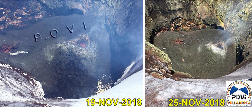 |
Figure 71. A small pyroclastic cone was visible at the bottom of the summit crater at Villarrica (about 70 m deep) on 19 November 2018 (left); it was still visible on 25 November (right). Courtesy of POVI (Volcán Villarrica, Resumen Gráfico del Comportamiento, November 2017 a Febrero 2019). |
During December 2018 webcam images showed steam plumes rising less than 350 m above the crater. Infrasound instruments identified two small explosions related to lava lake surface activity. SERNAGEOMIN noted a minor variation in the baseline of the inclinometers; continued monitoring indicated the variation was seasonal. A compilation by POVI of images of the summit crater during 2018 showed the evolution of the lava lake level during the year. It had dropped out of sight early in the year, rose to its highest level in July, and then lowered slightly, remaining stable for the last several months of the year (figure 72).
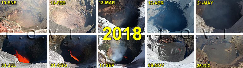 |
Figure 72. Evolution of the lava pit at Villarrica during 2018. During July the lava lake level increased and for November and December no significant changes were observed. Courtesy of POVI (Volcán Villarrica, Resumen Gráfico del Comportamiento, November 2017 a Febrero 2019). |
Between 25 December 2018 and 15 January 2019, financed with funds contributed by the Fundación Volcanes de Chile, POVI was able to install new HD webcams with continuous daily image recording, greatly improving the level of detail data available of the activity at the summit. POVI reported that after a five-week break, Strombolian explosions resumed on 3 January 2019; the lava fountains rose 20 m above the crater rim, and pyroclastic ejecta fell to the E. On 24 January the Strombolian explosions ejected ash, lapilli, and bombs up to 15 cm in diameter; the lava fountain was about 35 m high.
An explosion on 7 February reached about 29 m above the crater's edge; on 9 February a lava fountain three meters in diameter rose 17 m above the crater rim. Sporadic explosions were imaged on 12 February as well (figure 73). During a reconnaissance overflight on 24 February 2019, POVI scientists observed part of the lava pit at the bottom of the crater (figure 74). As of 28 February they noted a slight but sustained increase in the energy of the explosions. SERNAGEOMIN noted that steam plumes rose 400 m in January and 150 m during February, and incandescence was visible on clear nights during both months.
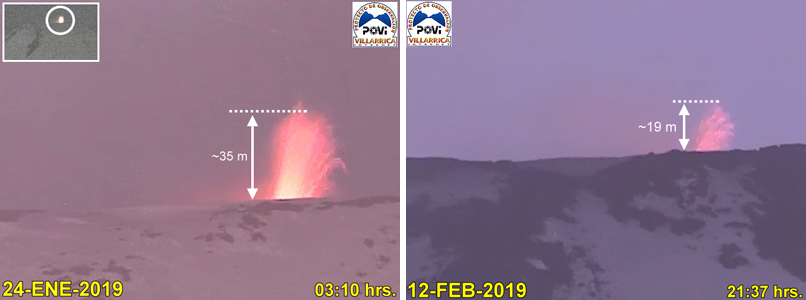 |
Figure 73. Strombolian activity at Villarrica in January and February 2019 was imaged with a new HD webcam on several occasions. On 24 January 2019 explosions ejected ash, lapilli, and bombs up to 15 cm in diameter; the lava fountain was about 35 m high (left); on 12 February 2019 explosions rose about 19 m above the crater rim (right). Courtesy of POVI (Volcán Villarrica, Resumen Gráfico del Comportamiento, November 2017 a Febrero 2019). |
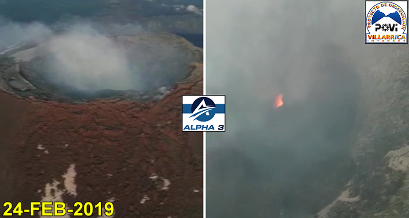 |
Figure 74. During a reconnaissance overflight on 24 February 2019, POVI scientists observed part of the lava pit at the bottom of the crater at Villarrica; gas and steam emissions and incandescence from small explosions were noted. Courtesy of POVI (Volcán Villarrica, Resumen Gráfico del Comportamiento, November 2017 a Febrero 2019). |
Information Contacts: Servicio Nacional de Geología y Minería (SERNAGEOMIN), Observatorio Volcanológico de Los Andes del Sur (OVDAS), Avda Sta María No. 0104, Santiago, Chile (URL: http://www.sernageomin.cl/); Proyecto Observación Villarrica Internet (POVI) (URL: http://www.povi.cl/).
Strombolian activity continued during March-August 2019 with an increase in July
Villarrica is a frequently active volcano in Chile with an active lava lake in the deep summit crater. It has been producing intermittent Strombolian activity since February 2015, soon after the latest reactivation of the lava lake; similar activity continued into 2019. This report summarizes activity during March-August 2019 and is based on reports from the Southern Andes Volcano Observatory (Observatorio Volcanológico de Los Andes del Sur, OVDAS), part of Chile's National Service of Geology and Mining (Servicio Nacional de Geología y Minería, SERNAGEOMIN), Projecto Observación Villarrica Internet (POVI), part of the Fundacion Volcanes de Chile research group, and satellite data.
OVDAS-SERNAGEOMIN reported that degassing continued through March with a plume reaching 150 m above the crater with visible incandescence through the nights. The lava lake activity continued to fluctuate and deformation was also recorded. POVI reported sporadic Strombolian activity throughout the month with incandescent ejecta reaching around 25 m above the crater on 17 and 24 March, and nearly 50 m above the crater on the 20th (figure 75).
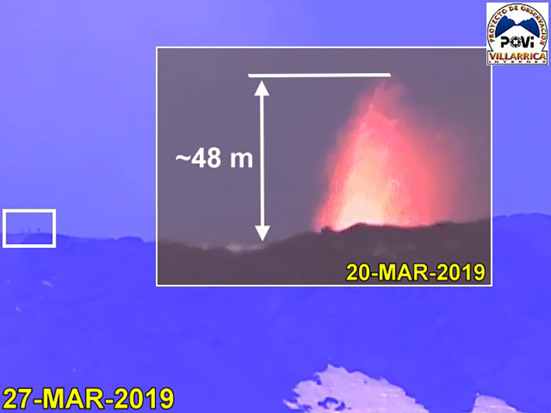 |
Figure 75. A webcam image of Villarrica at 0441 on 20 March 2019 shows Strombolian activity and incandescent ejecta reaching nearly 50 m above the crater. People are shown for scale in the white box to the left in the blue background image that was taken on 27 March. Photos taken about 6 km away from the volcano, courtesy of POVI. |
There was a slight increase in Strombolian activity reported on 7-8 April, with incandescent ballistic ejecta reaching around 50 m above the crater (figure 76). Although seismicity was low during 14-15 April, Strombolian activity produced lava fountains up to 70 m above the crater over those two days (figure 77). Activity continued into May with approximately 12 Strombolian explosions recorded on the night of 5-6 May erupting incandescent ejecta up to 50 m above the crater rim. Another lava fountaining episode was observed reaching around 70 m above the crater on 14 May (figure 78). POVI also noted that while this was one of the largest events since 2015, no significant changes in activity had been observed over the last five months. Throughout May, OVDAS-SERNAGEOMIN reported that the gas plume height did not exceed 170 m above the crater and incandescence was sporadically observed when weather allowed. SWIR (short-wave infrared) thermal data showed an increase in energy towards the end of May (figure 79).
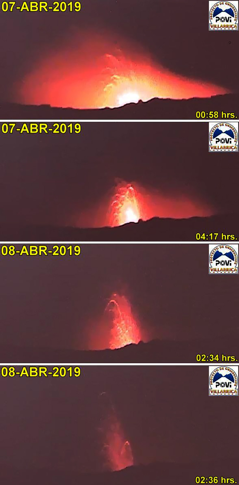 |
Figure 76. Strombolian activity at Villarrica on 7-8 April 2019 producing incandescent ballistic ejecta reaching around 50 m above the crater. Courtesy of POVI. |
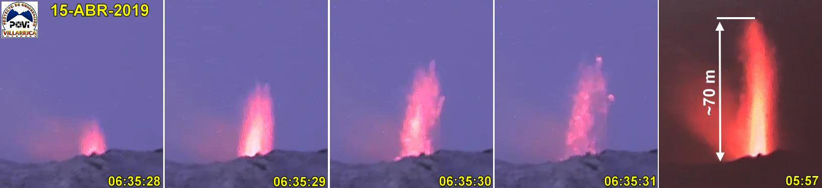 |
Figure 77. Images of Villarrica on 15 April show a lava fountain that reached about 70 m above the crater. Courtesy of POVI. |
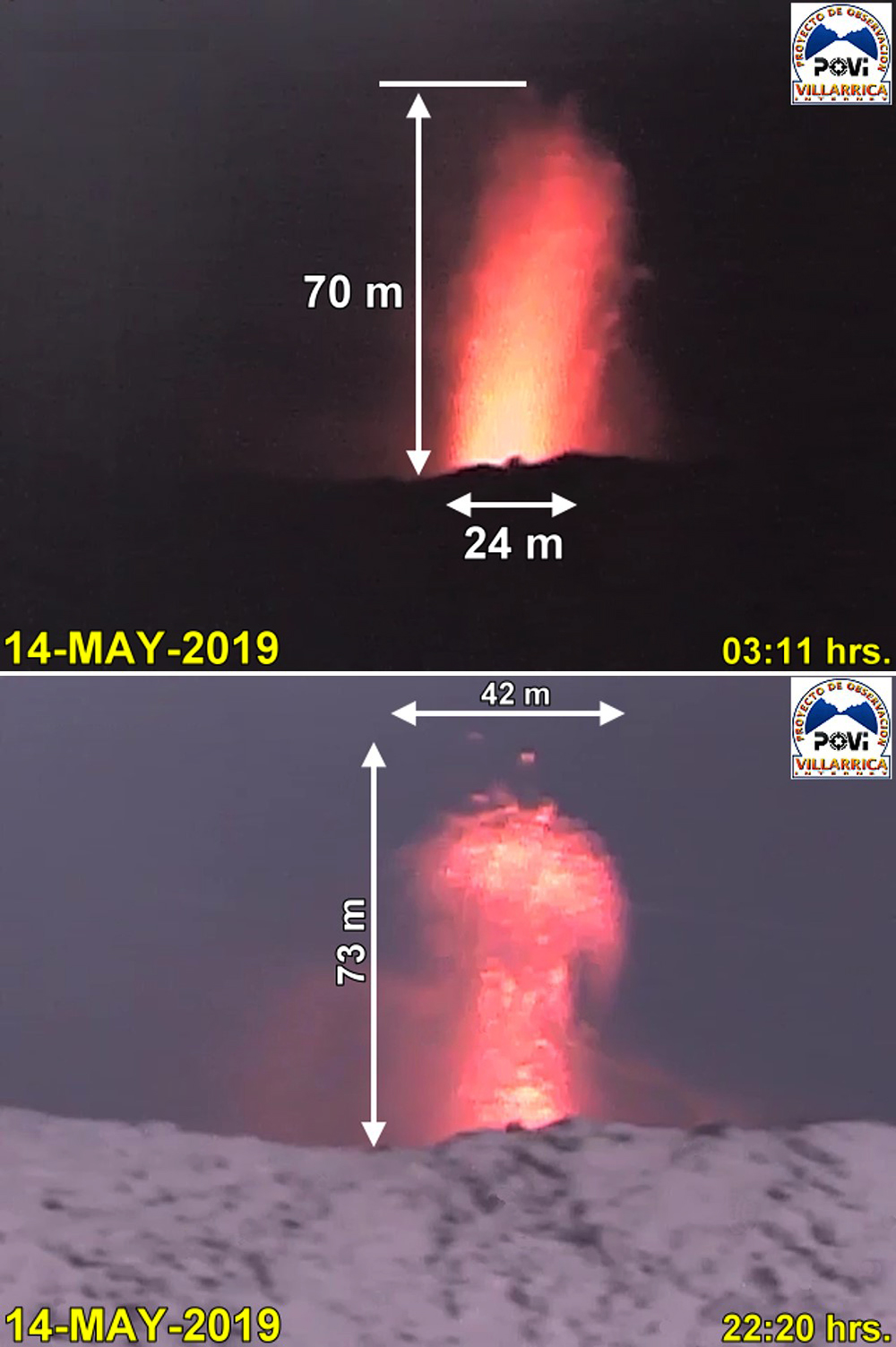 |
Figure 78. These images of Villarrica taken at 0311 and 2220 on 14 May 2019 show lava fountaining reaching 70-73 m above the crater. Courtesy of POVI. |
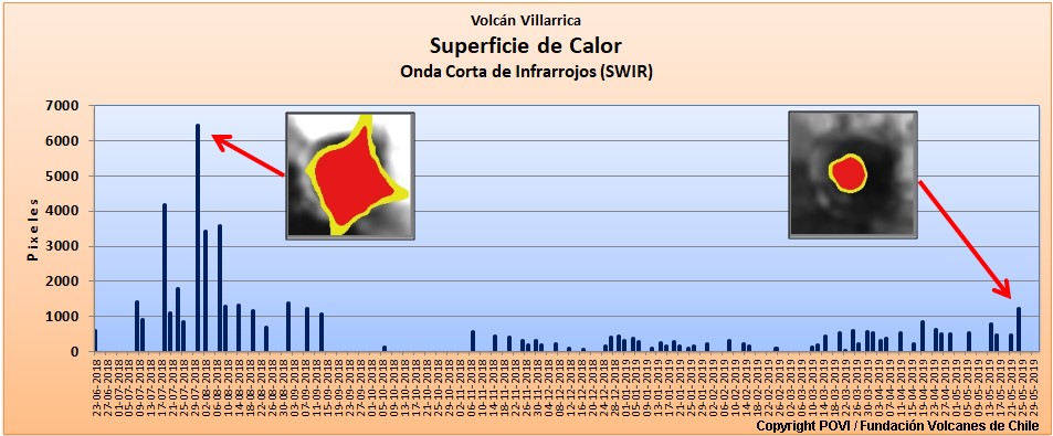 |
Figure 79. This graph shows the variation in short-wave infrared (SWIR) energy with the vertical scale indicating the number of pixels displaying high temperatures between 23 June 2018 and 29 May 2019. Courtesy of POVI. |
Ballistic ejecta were observed above the crater rim on 17 and 20 June 2019 (figure 80), and activity was heard on 20 and 21 June. Activity throughout the month remained similar to previous months, with a fluctuating lava lake and minor explosions. On 15 July a thermal camera imaged a ballistic bomb landing over 300 m from the crater and disintegrating upon impact. Incandescent material was sporadically observed on 16 July. Strombolian activity increased on 22 July with the highest intensity activity in four years continuing through the 25th (figure 81).
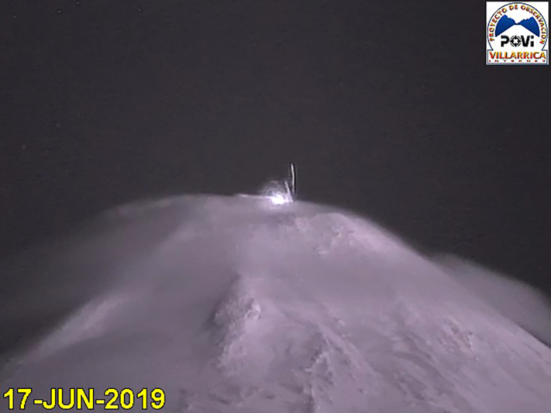 |
Figure 80. Ballistic ejecta is visible above the Villarrica crater in this infrared camera (IR940 nm) image taken on 17 June 2019. Courtesy of POVI. |
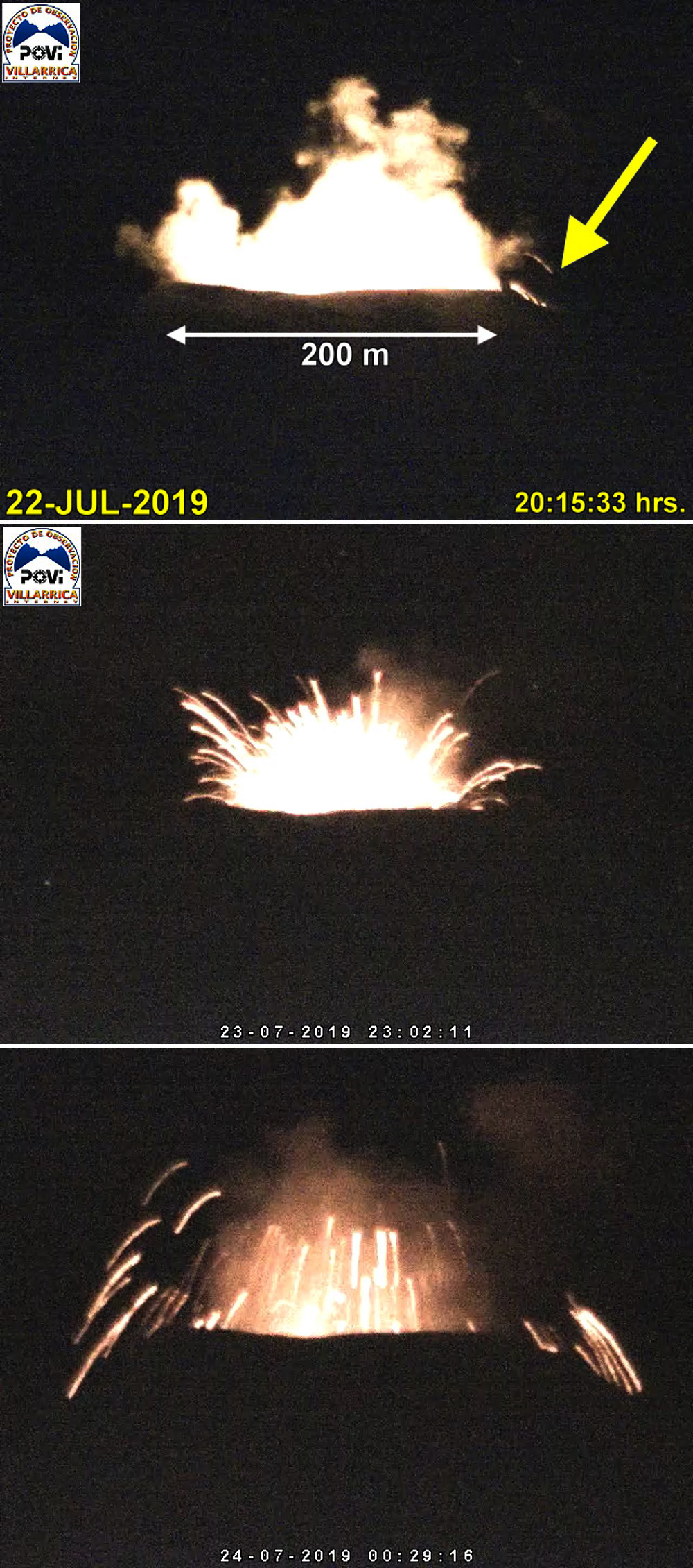 |
Figure 81. Strombolian activity at Villarrica on 22, 23, and 24 July with incandescent ballistic ejecta seen here above the summit crater. Courtesy of POVI. |
On 6 August the Alert Level was raised by SERNAGEOMIN from Green to Yellow (on a scale of Green, Yellow, Orange, and Red indicating the greatest level of activity) due to activity being above the usual background level, including ejecta confirmed out to 200 m from the crater with velocities on the order of 100 km/hour (figure 82). The temperature of the lava lake was measured at a maximum of 1,000°C on 25 July. POVI reported the collapse of a segment of the eastern crater rim, possibly due to snow weight, between 9 and 12 August. The MIROVA system showed an increase in thermal energy in August (figure 83) and there was one MODVOLC thermal alert on 24 July.
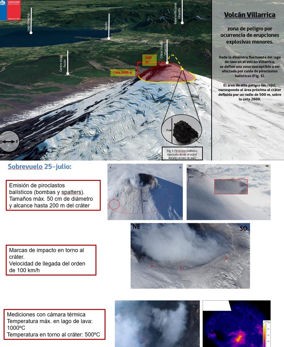 |
Figure 82. Observations during an overflight of Villarrica on 25 July 2019 showed that ballistic ejecta up to 50 cm in diameter had impacted out to 200 m from the crater. The velocities of these ejecta were likely on the order of 100 km/hour. The maximum temperature of the lava lake measured was 1,000°C, and 500°C was measured around the crater. Courtesy of SERNAGEOMIN. |
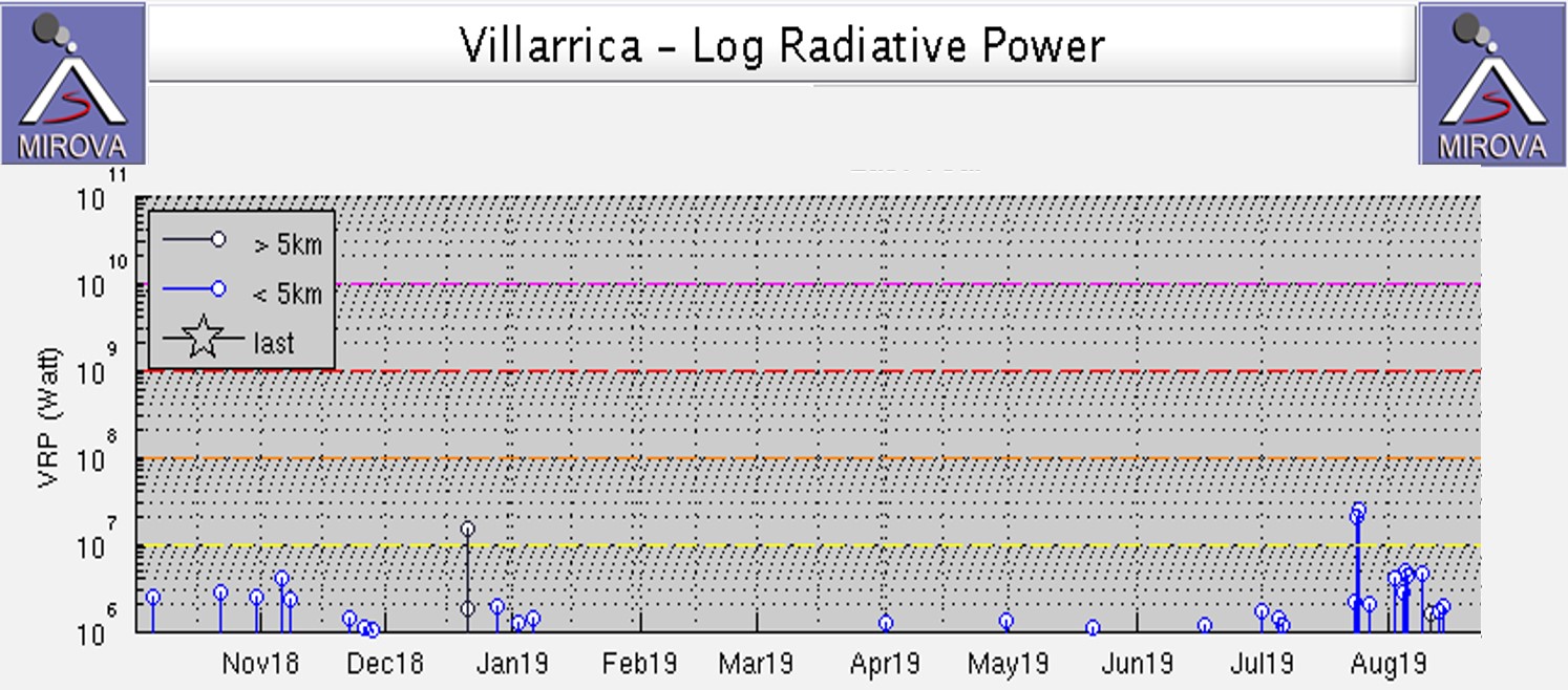 |
Figure 83. Thermal activity at Villarrica detected by the MIROVA system shows an increase in detected energy in August 2019. Courtesy of MIROVA. |
Information Contacts: Proyecto Observación Villarrica Internet (POVI) (URL: http://www.povi.cl/); Servicio Nacional de Geología y Minería (SERNAGEOMIN), Observatorio Volcanológico de Los Andes del Sur (OVDAS), Avda Sta María No. 0104, Santiago, Chile (URL: http://www.sernageomin.cl/); MIROVA (Middle InfraRed Observation of Volcanic Activity), a collaborative project between the Universities of Turin and Florence (Italy) supported by the Centre for Volcanic Risk of the Italian Civil Protection Department (URL: http://www.mirovaweb.it/); Hawai'i Institute of Geophysics and Planetology (HIGP) - MODVOLC Thermal Alerts System, School of Ocean and Earth Science and Technology (SOEST), Univ. of Hawai'i, 2525 Correa Road, Honolulu, HI 96822, USA (URL: http://modis.higp.hawaii.edu/).
Brief increase in explosions, mid-September 2019; continued thermal activity through February 2020
Historical eruptions at Chile's Villarrica, documented since 1558, have consisted largely of mild-to-moderate explosive activity with occasional lava effusion. An intermittently active lava lake at the summit has been the source of Strombolian activity, incandescent ejecta, and thermal anomalies for several decades; the current eruption has been ongoing since December 2014. Continuing activity during September 2019-February 2020 is covered in this report, with information provided by the Southern Andes Volcano Observatory (Observatorio Volcanológico de Los Andes del Sur, OVDAS), part of Chile's National Service of Geology and Mining (Servicio Nacional de Geología y Minería, SERNAGEOMIN), and Projecto Observación Villarrica Internet (POVI), part of the Fundacion Volcanes de Chile, a research group that studies volcanoes across Chile.
A brief period of heighted explosive activity in early September 2019 caused SERNAGEOMIN to raise the Alert Level from Yellow to Orange (on a four-color scale of Green-Yellow-Orange-Red) for several days. Increases in radiative power were visible in the MIROVA thermal anomaly data during September (figure 84). Although overall activity decreased after that, intermittent explosions were observed at the summit, and incandescence continued throughout September 2019-February 2020. Sentinel-2 satellite imagery indicated a strong thermal anomaly from the summit crater whenever the weather conditions permitted. In addition, ejecta periodically covered the area around the summit crater, and particulates often covered the snow beneath the narrow gas plume drifting S from the summit (figure 85).
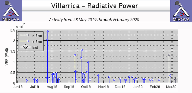 |
Figure 84. Thermal activity at Villarrica from 28 May 2019 through February 2020 was generally at a low level, except for brief periods in August and September 2019 when larger explosions were witnessed and recorded in seismic data and higher levels of thermal activity were noted by the MIROVA project. Courtesy of MIROVA. |
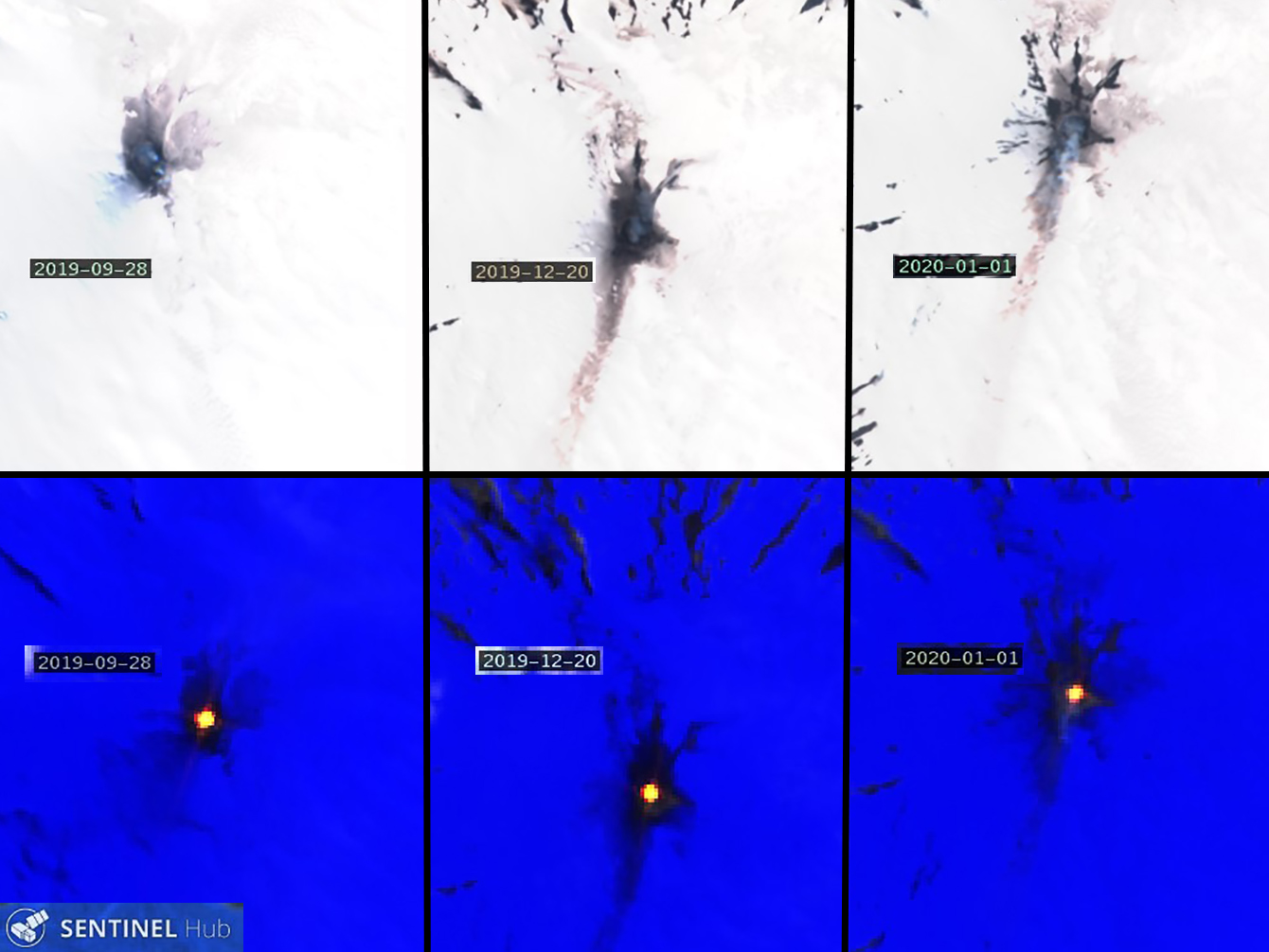 |
Figure 85. Natural-color (top) and Atmospheric penetration (bottom) renderings of three different dates during September 2019-February 2020 show typical continued activity at Villarica during the period. Dark ejecta periodically covered the snow around the summit crater, and streaks of particulate material were sometimes visible on the snow underneath the plumes of bluish gas drifting S from the volcano (top images). Persistent thermal anomalies were recorded in infrared satellite data on the same dates (bottom images). Dates recorded are (left to right) 28 September 2019, 20 December 2019, and 1 January 2020. Natural color rendering uses bands 4,3, and 2, and Atmospheric penetration rendering uses bands 12, 11, and 8a. Courtesy of Sentinel Hub Playground. |
SERNAGEOMIN raised the Alert Level from Green to Yellow in early August 2019 due to the increase in activity that included incandescent ejecta and bombs reaching 200 m from the summit crater (BGVN 44:09). An increase in seismic tremor activity on 8 September was accompanied by vigorous Strombolian explosions reported by POVI. The following day, SERNAGEOMIN raised the Alert Level from Yellow to Orange. Poor weather prevented visual observations of the summit on 8 and 9 September, but high levels of incandescence were observed briefly on 10 September. Incandescent ejecta reached 200 m from the crater rim late on 10 September (figure 86). Activity increased the next day with ejecta recorded 400 m from the crater, and the explosions were felt 12 km from the summit.
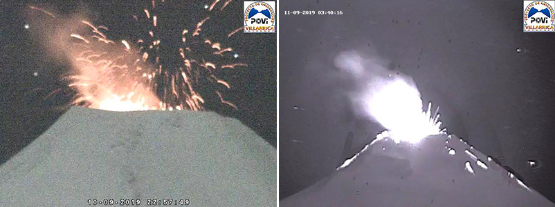 |
Figure 86. A new pulse of activity at Villarrica reached its maximum on 10 (left) and 11 (right) September 2019. Incandescent ejecta reached 200 m from the crater rim on 10 September and up to 400 m the following day. Courtesy of POVI (Volcan Villarrica, Resumen grafico del comportamiento, Septiembre 2019 a enero 2020). |
Explosions decreased in intensity by 13 September, but avalanches of incandescent material were visible on the E flank in the early morning hours (figure 87). Small black plumes later in the day were interpreted by POVI as the result of activity from landslides within the crater. Fine ash deposited on the N and NW flanks during 16-17 September was attributed to wind moving ash from within the crater, and not to new emissions from the crater (figure 88). SERNAGEOMIN lowered the Alert Level to Yellow on 16 September as tremor activity decreased significantly. Activity continued to decrease during the second half of September; incandescence was moderate with no avalanches observed, and intermittent emissions with small amounts of material were noted. Degassing of steam plumes rose up to 120 m above the crater.
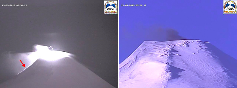 |
Figure 87. By 13 September 2019, a decrease in activity at Villarrica was apparent. Incandescence (red arrow) was visible on the E flank of Villarrica early on 13 September (left). Fine ash, likely from small collapses of new material inside the vent, rose a short distance above the summit later in the day (right). Courtesy of POVI (Volcan Villarrica, Resumen grafico del comportamiento, Septiembre 2019 a Enero 2020). |
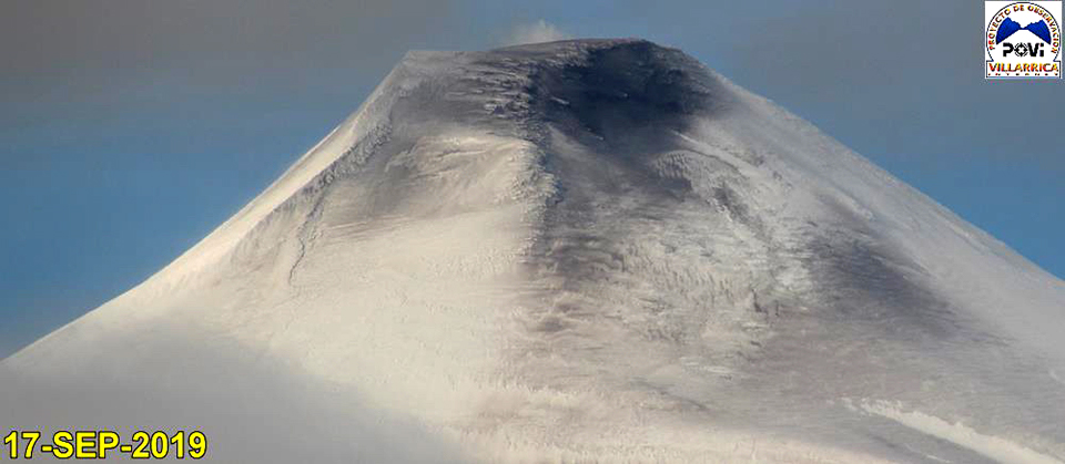 |
Figure 88. Fine-grained material covered the summit of Villarrica on 17 September 2019. POVI interpreted this as a result of strong winds moving fine ash-sized particles from within the crater and depositing them on the N and NW flanks. Courtesy of POVI (Volcan Villarrica, Resumen grafico del comportamiento, Septiembre 2019 a enero 2020). |
Low-altitude degassing was typical activity during October-December 2019; occasionally steam and gas plumes rose 300 m above the summit, but they were generally less than 200 m high. Incandescence was visible at night when weather conditions permitted. Occasional Strombolian explosions were observed in the webcam (figure 89). During January and February 2020, similar activity was reported with steam plumes observed to heights of 300-400 m above the summit, and incandescence on nights where the summit was visible (figure 90). A drone overflight on 19 January produced a clear view into the summit crater revealing a 5-m-wide lava pit about 120 m down inside the crater (figure 91).
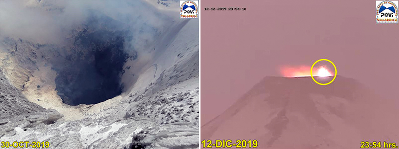 |
Figure 89. Activity continued at a lower level at the summit of Villarrica from October-December 2019. The 30-m-wide vent at the bottom of the summit crater (120 m deep) of Villarrica (left) was emitting wisps of bluish gas on 30 October 2019. Sporadic Strombolian explosions ejected material around the crater rim on 12 December (right). Courtesy of POVI (Volcan Villarrica, Resumen grafico del comportamiento, Septiembre 2019 a enero 2020). |
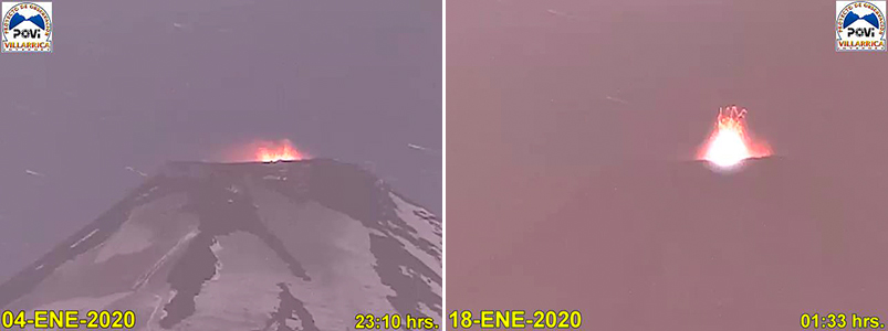 |
Figure 90. Small explosive events were recorded at Villarrica during January and February 2020, including these events on 4 (left) and 18 (right) January where ejecta reached about 50 m above the crater rim. Courtesy of POVI (Volcan Villarrica, Resumen grafico del comportamiento, Septiembre 2019 a Enero 2020). |
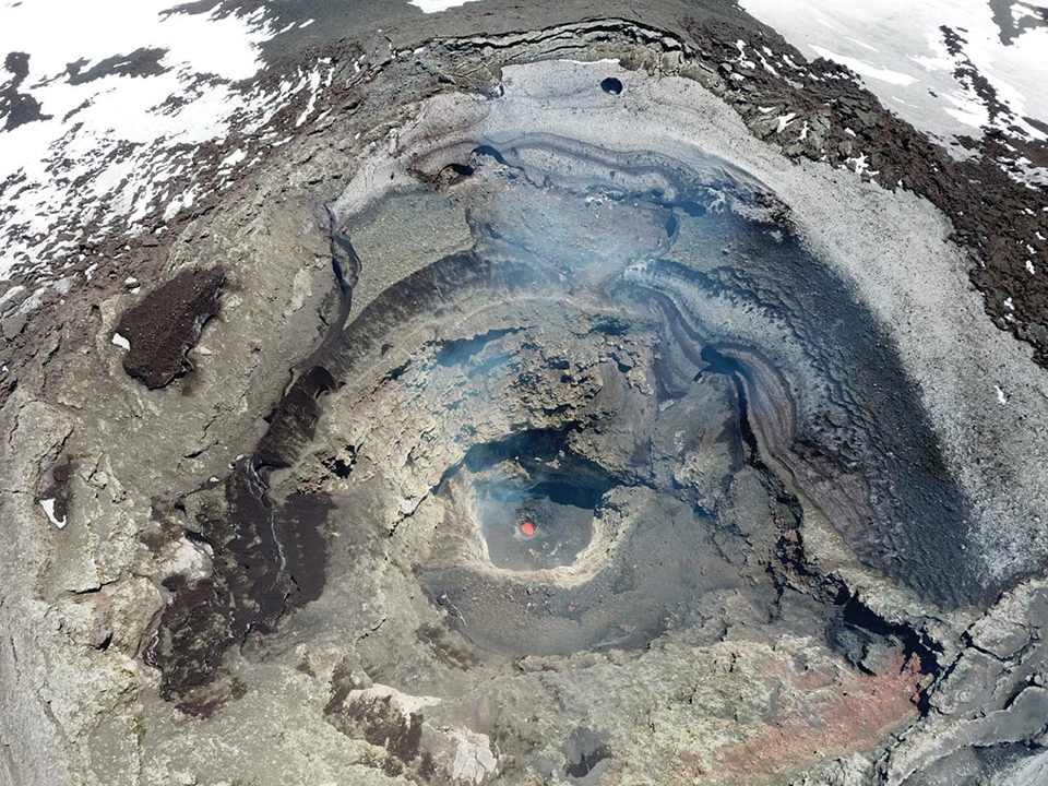 |
Figure 91. An oblique view into the bottom of the summit crater of Villarrica on 19 January 2020 was captured by drone. The diameter of the lava pit was calculated at about 5 m and was about 120 m deep. Image copyright by Leighton M. Watson, used with permission; courtesy of POVI (Volcan Villarrica, Resumen grafico del comportamiento, Septiembre 2019 a Enero 2020). |
Information Contacts: Servicio Nacional de Geología y Minería (SERNAGEOMIN), Observatorio Volcanológico de Los Andes del Sur (OVDAS), Avda Sta María No. 0104, Santiago, Chile (URL: http://www.sernageomin.cl/); Proyecto Observación Villarrica Internet (POVI) (URL: http://www.povi.cl/); MIROVA (Middle InfraRed Observation of Volcanic Activity), a collaborative project between the Universities of Turin and Florence (Italy) supported by the Centre for Volcanic Risk of the Italian Civil Protection Department (URL: http://www.mirovaweb.it/); Sentinel Hub Playground (URL: https://www.sentinel-hub.com/explore/sentinel-playground); Leighton M. Watson, Department of Earth Sciences at the University of Oregon, Eugene, OR 97403-1272, USA (URL: https://earthsciences.uoregon.edu/).
Continued summit incandescence February-August 2020 with larger explosions in July and August
Historical eruptions at Chile's Villarrica, documented since 1558, have consisted largely of mild-to-moderate explosive activity with occasional lava effusion. An intermittently active lava lake at the summit has been the source of Strombolian activity, incandescent ejecta, and thermal anomalies for several decades; the current eruption has been ongoing since December 2014. Continuing activity during February-August 2020 is covered in this report, with information provided by the Southern Andes Volcano Observatory (Observatorio Volcanológico de Los Andes del Sur, OVDAS), part of Chile's National Service of Geology and Mining (Servicio Nacional de Geología y Minería, SERNAGEOMIN), and Projecto Observación Villarrica Internet (POVI), part of the Fundacion Volcanes de Chile, a private research group that studies volcanoes across Chile. Sentinel satellite imagery also provided valuable data.
Intermittent incandescence was observed at the summit throughout February-August 2020, which was reflected in the MIROVA thermal anomaly data for the period (figure 92). Continuous steam and gas emissions with occasional ash plumes rose 100-520 m above the summit. Every clear satellite image of Villarrica from February -August 2020 showed either a strong thermal anomaly within the summit crater or a dense cloud within the crater that prevented the heat signal from being measured. Sentinel-2 captured on average twelve images of Villarrica each month (figure 93). Larger explosions on 25 July and 7 August produced ejecta and ash emissions.
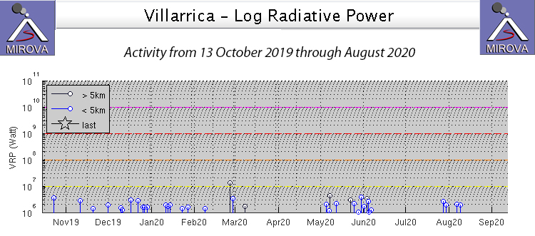 |
Figure 92. Thermal anomaly data for Villarrica from 13 October 2019 through August 2020 showed intermittent periods of activity. Incandescence was intermittently reported from the summit and satellite imagery showed a persistent hot spot inside the summit crater throughout the period. Courtesy of MIROVA. |
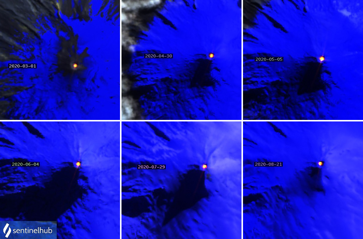 |
Figure 93. Examples of strong thermal anomalies inside the summit crater of Villarrica each month from March-August 2020 are shown with dates on the image. Sentinel-2 satellite imagery with Atmospheric penetration rendering (bands 12, 11, 8A) showed thermal anomalies at the summit in all clear satellite images during the period. Courtesy of Sentinel Hub Playground. |
Primarily white gas emissions rose up to 400 m above the summit during the first half of February 2020 and to 320 m during the second half. Incandescence was observed on clear nights. Incandescent ejecta was captured in the POVI webcam on 7 February (figure 94). Sentinel-2 satellite imagery showed bright thermal anomalies at the summit on 5, 8, 10, 13, 18, 20, 23, 25, and 28 February, nine of the eleven days that images were taken; the other days were cloudy.
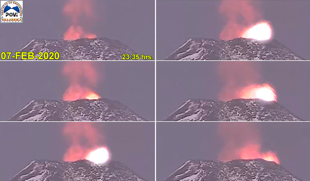 |
Figure 94. Incandescent ejecta at the summit of Villarrica was captured in the POVI webcam late on 7 February 2020. Time sequence runs from top to bottom, then left to right. Courtesy of POVI. |
Villarrica remained at Alert Level Yellow (on a four-level Green-Yellow-Orange-Red scale) in March 2020. Plumes of gas rose 350 m above the crater during the first half of March. The POVI webcam captured incandescent ejecta on 1 March (figure 95). SERNAGEOMIN reported continuous white emissions and incandescence at night when the weather permitted. During the second half of March emissions rose 300 m above the crater; they were mostly white but occasionally gray and drifted N, S, and SE. Nighttime incandescence could be observed from communities that were tens of kilometers away on multiple occasions (figure 96). Sentinel-2 satellite imagery showed bright thermal anomalies at the summit on 1, 3, 4, 6, 9, 11, 14, 16, 19, 26, 29, and 31 March, twelve of the fourteen days images were taken. The other days were cloudy.
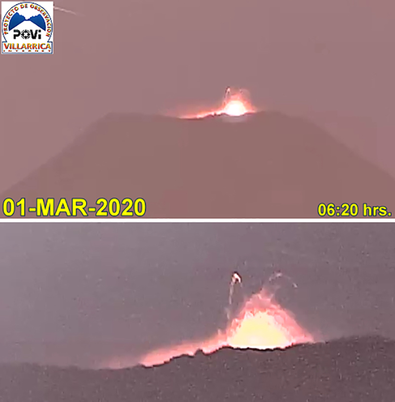 |
Figure 95. Incandescent ejecta rose from the summit of Villarrica in the early morning of 1 March 2020. Courtesy of POVI. |
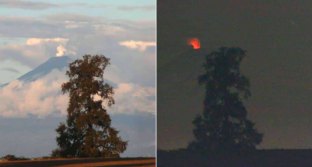 |
Figure 96. Nighttime incandescence was observed on 24 March 2020 tens of kilometers away from Villarrica. Courtesy of Luis Orlando. |
During the first half of April 2020 plumes of gas rose 300 m above the crater, mostly as continuous degassing of steam. Incandescence continued to be seen on clear nights throughout the month. Steam plumes rose 150 m high during the second half of the month. A series of Strombolian explosions on 28-29 April ejected material up to 30 m above the crater rim (figure 97). Sentinel-2 satellite imagery showed bright thermal anomalies at the summit on 3, 8, 10, 13, 20, and 30 April, six of the twelve days images were taken; other days were cloudy.
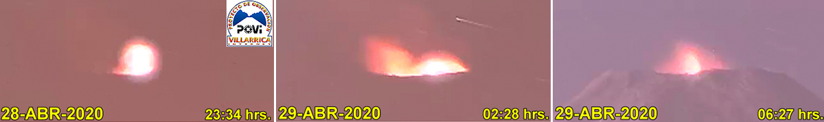 |
Figure 97. A series of Strombolian explosions on 28-29 April 2020 at Villarrica ejected material up to 30 m above the crater rim. Courtesy of POVI. |
Daily plumes of steam rose 160 m above the summit crater during the first half of May 2020; incandescence was visible on clear nights throughout the month. During 5-7 May webcams captured episodes of dark gray emissions with minor ash that, according to SERNAGEOMIN, was related to collapses of the interior crater walls. Plumes rose as high as 360 m above the crater during the second half of May. The continuous degassing was gray and white with periodic ash emissions. Pyroclastic deposits were noted in a radius of 50 m around the crater rim associated with minor explosive activity from the lava lake. The POVI infrared camera captured a strong thermal signal rising from the summit on 29 May (figure 98), although no visual incandescence was reported. Residents of Coñaripe (17 km SSW) could see steam plumes at the snow-covered summit on 31 May (figure 99). Sentinel-2 satellite imagery showed bright thermal anomalies at the summit on 5, 13, 20, 23, 25 and 30 May, six of the twelve days images were taken. The other days were cloudy.
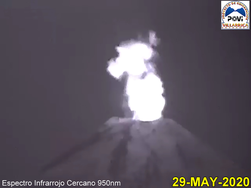 |
Figure 98. The POVI infrared camera captured a strong thermal signal rising from the summit of Villarrica on 29 May 2020; no visual incandescence was noted. Courtesy of POVI. |
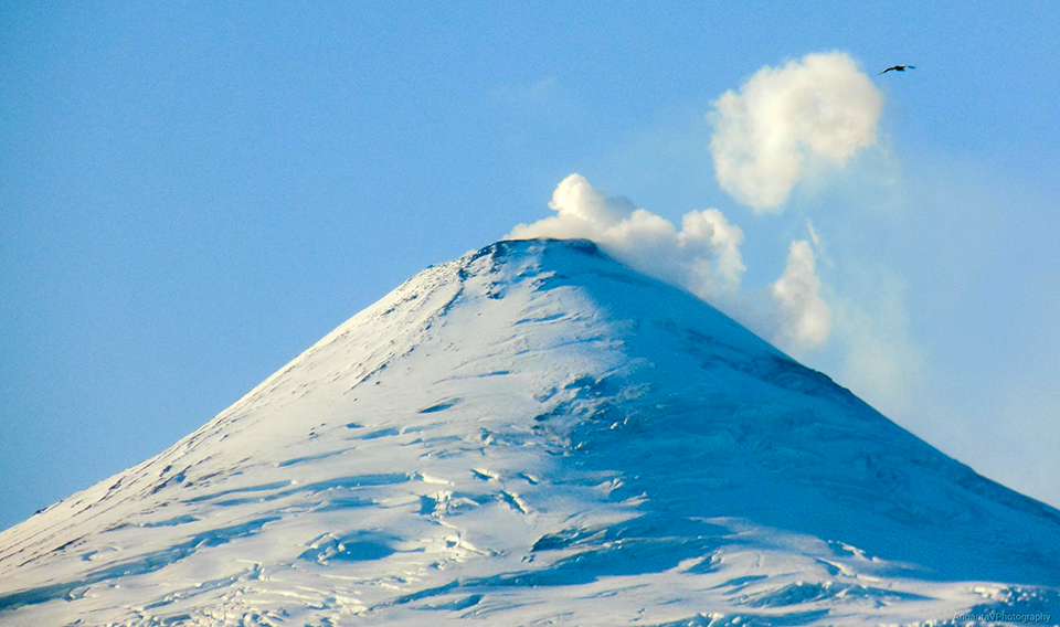 |
Figure 99. Residents of Coñaripe (17 km SSW) could see steam plumes at the snow-covered summit of Villarrica on 31 May 2020. Courtesy of Laura Angarita. |
For most of the first half of June, white steam emissions rose as high as 480 m above the crater rim. A few times, emissions were gray, attributed to ash emissions from collapses of the inner wall of the crater by SERNAGEOMIN. Incandescence was visible on clear nights throughout the month. Vertical inflation of 1.5 cm was noted during the first half of June. Skies were cloudy for much of the second half of June; webcams only captured images of the summit on 21 and 27 June with 100-m-high steam plumes. Sentinel-2 satellite imagery showed bright thermal anomalies at the summit on 4, 7, and 14 June, three of the twelve days images were taken. The other days were cloudy.
Atmospheric clouds prevented most observations of the summit during the first half of July (figure 100); during brief periods it was possible to detect incandescence and emissions rising to 320 m above the crater. Continuous degassing was observed during the second half of July; the highest plume rose to 360 m above the crater on 23 July. On 25 July, monitoring stations in the vicinity of Villarrica registered a large-period (LP) seismic event associated with a moderate explosion at the crater. It was accompanied by a 14.7 Pa infrasound signal measured 1 km away. Meteorological conditions did not permit views of any surface activity that day, but a clear view of the summit on 28 July showed dark tephra on the snow around the summit crater (figure 101). Sentinel-2 satellite imagery showed bright thermal anomalies at the summit on 2 and 29 July, two of the twelve days images were taken. The other days were either cloudy or had steam obscuring the summit crater.
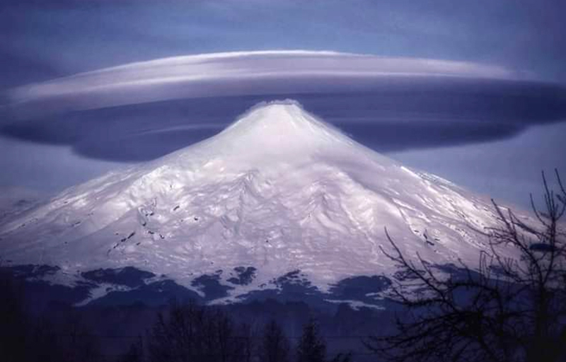 |
Figure 100. Although a multi-layer cap cloud formed over the summit of Villarrica on 15 July 2020, steam emissions could be seen close to the summit drifting down the slope. Cap clouds form when a stable airstream rises to pass over a peak and cools, condensing moisture into clouds. Photograph by Sebastián Campos, courtesy of Geography Fans. |
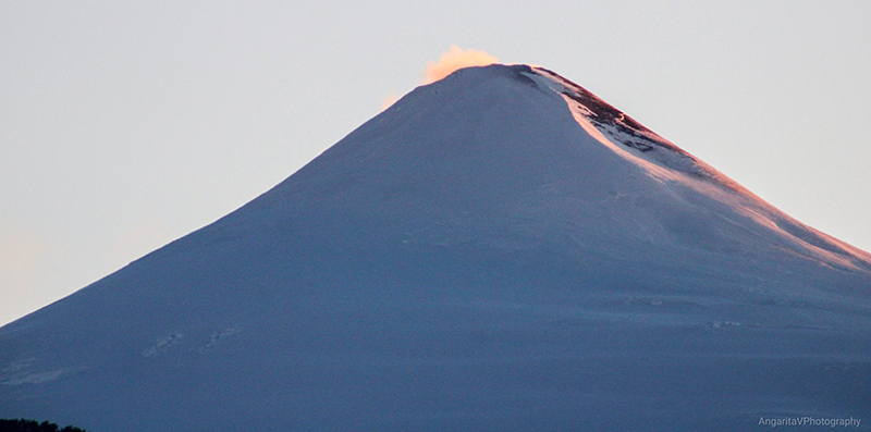 |
Figure 101. Dark tephra appeared near the summit of Villarrica on 28 July 2020; an explosion had been measured seismically on 25 July but clouds obscured visual observations. Image taken from Coñaripe, courtesy of Laura Angarita. |
An explosion on 7 August at 1522 local time (1922 UTC) produced an LP seismic signal and a 10 Pa infrasound signal. Webcams were able to capture an image of the explosion which produced a dense plume of steam and ash that rose 370 m above the summit and drifted SE (figure 102). The highest plumes in the first half of August reached 520 m above the summit on 7 August. Sporadic emissions near the summit level were reported by the Buenos Aires VAAC the following day but were not observed in satellite imagery. When weather permitted during the second half of the month, continuous degassing to 200 m above the crater was visible on the webcams. SERNAGEOMIN participated in a webinar on 20 August 2020 discussing safety at Villarrica and showed an image of the summit crater taken during an overflight on 19 August (figure 103). Sentinel-2 satellite imagery showed bright thermal anomalies at the summit on 6, 21, and 31 August, three of the thirteen days images were taken. The other days were cloudy.
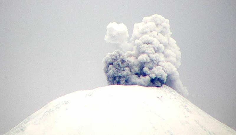 |
Figure 102. An explosion at Villarrica on 7 August 2020 at 1522 local time (1922 UTC) produced an LP seismic signal and 10 Pa infrasound signal. Webcams were able to capture an image of the explosion which produced a dense plume of steam and ash that rose 370 m above the summit and drifted SE Courtesy of SERNAGEOMIN (Reporte Especial de Actividad Volcanica (REAV), Region De La Araucania y Los Rios, volcan Villarrica, 7 de Agosto de 2020, 16:15 Hora local). |
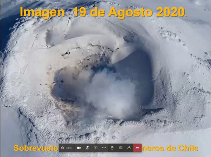 |
Figure 103. SERNAGEOMIN participated in a webinar on 20 August 2020 discussing safety at Villarrica and showed an image of the summit crater taken during an overflight on 19 August. Courtesy of Turismo Integral. |
Information Contacts: Servicio Nacional de Geología y Minería (SERNAGEOMIN), Observatorio Volcanológico de Los Andes del Sur (OVDAS), Avda Sta María No. 0104, Santiago, Chile (URL: http://www.sernageomin.cl/); MIROVA (Middle InfraRed Observation of Volcanic Activity), a collaborative project between the Universities of Turin and Florence (Italy) supported by the Centre for Volcanic Risk of the Italian Civil Protection Department (URL: http://www.mirovaweb.it/); Sentinel Hub Playground (URL: https://www.sentinel-hub.com/explore/sentinel-playground); Proyecto Observación Villarrica Internet (POVI), (URL: http://www.povi.cl/, https://twitter.com/povi_cl/status/1237541250825248768); Luis Orlando (URL: https://twitter.com/valepizzas/status/1242657625495539712); Laura Angarita (URL: https://twitter.com/AngaritaV/status/1267275374947377152, https://twitter.com/AngaritaV/status/1288086614422573057); Geography Fans (URL: https://twitter.com/Geografia_Afic/status/1284520850499092480); Turismo Integral (URL: https://turismointegral.net/expertos-entregan-recomendaciones-por-actividad-registrada-en-volcan-villarrica/).
Explosions, ash plumes, crater incandescence, and an active lava lake during September 2020-February 2021
Villarrica, located in Chile, has had historical eruptions dating back to 1558. The current eruption period began in December 2014 and more recently has been characterized by summit crater incandescence, Strombolian explosions, and ash emissions (BGVN 45:09). This report covers activity during September 2020 through February 2021, which consists of an active lava lake, explosions, ash plumes, and nighttime crater incandescence. Information is provided by the Southern Andes Volcano Observatory (Observatorio Volcanológico de Los Andes del Sur, OVDAS), part of Chile's National Service of Geology and Mining (Servicio Nacional de Geología y Minería, SERNAGEOMIN), the Projecto Observación Villarrica Internet (POVI), part of the Fundacion Volcanes de Chile, a private research group that studies volcanoes across Chile, the Buenos Aires Volcanic Ash Advisory Center (VAAC), and various satellite data.
Activity during September 2020 was characterized by an active lava lake, white gas-and-steam plumes that rose 500 m above the crater, nighttime crater incandescence that could be observed on clear days, and sporadic ash emissions produced by minor explosions. During 5 and 7 September tephra deposits extended up to 36 m on the E and SE flanks, according to satellite data. On 25 September the seismic network recorded a long-period earthquake associated with a moderate explosion at 1350, which produced an ash plume that rose 800 m above the crater and drifted ENE (figure 104); blocks of ejecta were deposited around the crater. A second explosion was recorded at 1829 in conjunction with another long-period event, which generated an ash plume that rose 450 m above the crater (figure 104). Sentinel L2 A satellite images were used to determine that ashfall extended 3.8 km SSE, 865 m SE, and 275 m N as a result of the explosions during the day. The POVI webcam captured incandescent ejecta at night on 27 September (figure 105).
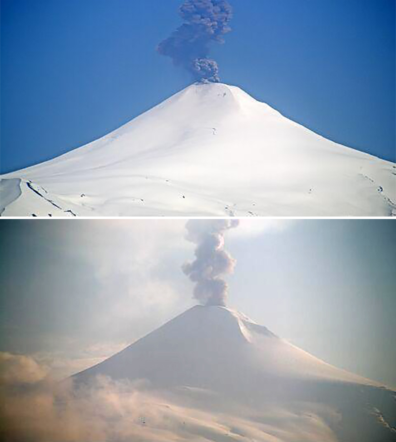 |
Figure 104. Explosions at Villarrica on 25 September 2020 at 1350 (top) and 1829 (bottom) produced a long-period seismic signal and ash plumes that rose 800 m and 450 m above the crater, respectively and drifted ENE. Courtesy of SERNAGEOMIN (Reporte Especial de Actividad Volcanica (REAV), Region De La Araucania y Los Rios, Volcan Villarrica, 25 de septiembre de 2020, 14:35 Hora local y 25 de septiembre de 2020, 19:20 Hora local). |
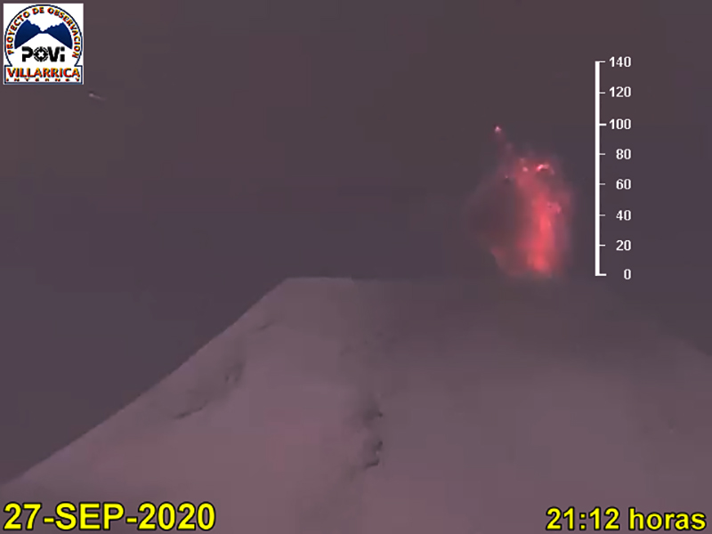 |
Figure 105. Incandescent ejecta up to 100 m above the summit of Villarrica was captured in the POVI webcam at night on 27 September 2020. Courtesy of POVI. |
Intermittent white gas-and-steam plumes, ash explosions, and nighttime crater incandescence continued during October. On 4 October SERNAGEOMIN reported a long-period event accompanied by a moderate explosion at 1130, generating an ash plume that rose 450 m above the crater and drifted NE. The next day on 5 October two long-period events were recorded at 1343 and 1347 associated with explosions, resulting in ash plumes that rose to 400 m above the crater and drifted SE (figure 106). On 12 October a satellite image showed an ash plume drifting 2.5 km NE and a strip of tephra deposits measuring 200 m wide and 3 km long on the NE flank, as a result of two eruptive events on 9 October, according to POVI and Sentinel-2 satellite imagery.
 |
Figure 106. Explosions at Villarrica on 5 October 2020 produced a long-period seismic signal and an ash plume that rose 400 m above the crater and drifted SE. Courtesy of SERNAGEOMIN (Reporte Especial de Actividad Volcanica (REAV), Region De La Araucania y Los Rios, Volcan Villarrica, 5 de octubre de 2020, 14:20 Hora local). |
Moderate explosions were detected at 0534 and 0804 on 15 October, associated with two long-period earthquakes. As a result, ash plumes rose as high as 900 m above the crater and gas-and-steam plumes rose to 450 m, according to SERNAGEOMIN. The explosion at 0534 was accompanied by crater incandescence and incandescent ejecta that were deposited on the E flank as far as 3 km. An analysis of Planet Scope and Sentinel-2 satellite images showed that ash deposits extended 4.4 km NE. On 20 October an explosion and long-period event were recorded at 1722 that resulted in an ash plume 240 m above the crater that drifted S (figure 107). Explosions recorded during 22-23 October produced ash plumes that rose 780 m and 180 m above the crater, respectively, according to a Buenos Aires VAAC report and SERNAGEOMIN. The event on 22 October deposited tephra up to 3.8 km on the E flank.
 |
Figure 107. An explosion at Villarrica on 20 October 2020 at 1722 was characterized by a long-period earthquake and a dense, gray ash plume that rose 240 m above the crater and drifted S. Courtesy of SERNAGEOMIN (Reporte Especial de Actividad Volcanica (REAV), Region De La Araucania y Los Rios, Volcan Villarrica, 20 de octubre de 2020, 18:00 Hora local). |
Ash explosions continued in November, accompanied by intermittent nighttime crater incandescence and white gas-and-steam plumes. On 5 November a pulse of ash was observed at 1442 that rose 350 m above the crater and drifted NW. Similar activity was noted on 6 November at 0757 and 0808 when ash rose 350 m above the crater and at 1412 when ash rose 250 m above the crater, both of which drifted NW (figure 108). According to a Buenos Aires VAAC report on 7 November, an isolated ash plume was detected in satellite images up to 4.3 km altitude, drifted ESE. A Differential Absorption Optical Spectroscopy Unit (DOAS) showed average values of SO2 totaling 140 tons/day during 7-8 and 15 November with a maximum daily value of 168 tons/day on 7 November. An explosive event at 0051 on 8 November ejected incandescent material and produced an ash plume that rose 220 m above the crater (figure 108). On 10 November OVDAS reported an ash plume rose 320 m above the crater and drifted SSW, accompanied by continuous seismic tremor at 1514. Ash continued to be reported during 16-17 November rising 160 m above the crater and to 3.7 km altitude, respectively. Data from the DOAS showed that SO2 emissions had slightly increased to an average of 166 tons/day during 16-30 November, with a maximum daily value of 549 tons/day on 22 November.
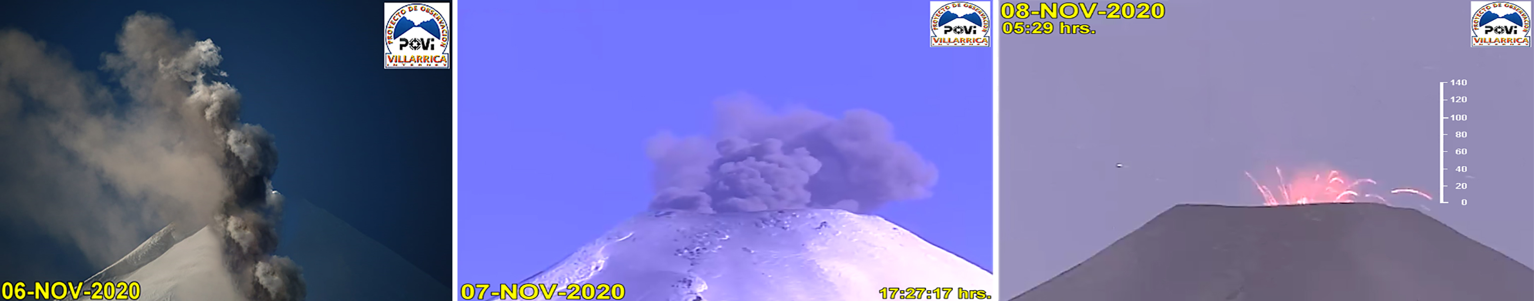 |
Figure 108. Explosions that generated ash and incandescent ejecta at the summit of Villarrica were captured by the POVI webcam during 6-8 November 2020 (left to right). Courtesy of POVI. |
The number of ash events decreased in December compared to the previous months, though similar activity persisted. On clear nights, crater incandescence was visible, accompanied by white gas-and-steam emissions. SERNAGEOMIN reported a single long-period earthquake associated with a moderate explosion at 1844 on 5 December with a resulting ash plume that rose 160 m above the crater and drifted SSE; some ashfall was detected within 500 m of the crater, based on Sentinel-2, Pleiades, and SkySat data, and incandescent material was deposited on the SSE flanks (figure 109). According to POVI, during an overflight on 9 December scientists observed a lava lake 10-15 m in diameter that was partially covered by solidified floating black lava. Small pulses of gas and ash were observed in the lava lake. Additionally, ballistic blocks and pyroclasts that measured a maximum of 20 cm in diameter had been ejected up to 800 m from the crater during previous eruptive events. The average SO2 value was 178 tons/day with a maximum daily value of 353 tons/day on 7 December 2020, according to DOAS data.
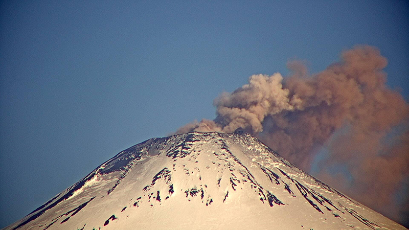 |
Figure 109. An explosion at Villarrica on 5 December 2020 at 1844 produced a long-period seismic signal along with an ash plume that rose 160 m crater and drifted SSE. Courtesy of SERNAGEOMIN (Reporte Especial de Actividad Volcanica (REAV), Region De La Araucania y Los Rios, Volcan Villarrica, 5 de diciembre de 2020, 19:50 Hora local). |
On 16 December at both 1146 and 1156 SERNAGEOMIN reported two ash pulses associated with long-period events. The first ash emission rose 160 m above the crater and drifted NW; the second rose 280 m above the crater and drifted 500 m NE. On 17 December at 1716 another ash plume associated with a long-period event rose 720 m above the crater and drifted ESE (figure 110). Pyroclastic deposits were reported up to 1.3 km N, 3.3 km E, 5 km SE, and 1.8 km SW from the crater, according to data obtained from Sentinel-2 and SkySat. During 18-19 December seismicity increased, intense crater incandescence was visible, and a notable sulfur odor was noted, according to POVI reports. Minor ash emissions rose to low heights on 22 December.
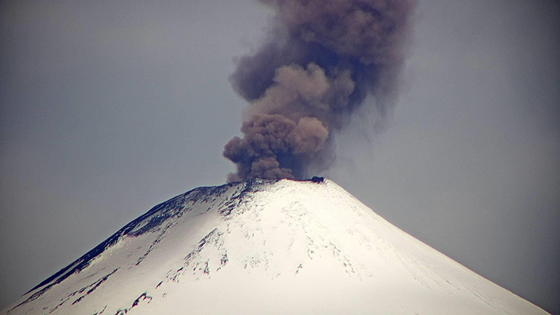 |
Figure 110. An explosion at Villarrica on 17 December 2020 at 1716 produced an ash plume that rose 720 m above the crater and drifted ESE. Courtesy of SERNAGEOMIN (Reporte Especial de Actividad Volcanica (REAV), Region De La Araucania y Los Rios, Volcan Villarrica, 17 de diciembre de 2020, 17:50 Hora local). |
During January 2021, the number of explosions with ash plumes continued to decrease compared to the previous months. On clear weather days, occasional nighttime crater incandescence was observed, as well as white gas-and-steam emissions of variable intensities. During an overflight on 2 January scientists observed an incandescent vent at the bottom of the crater that had a solidified lava bridge connecting across a partially crusted-over top (figure 111). DOAS data showed that the average mass of SO2 plumes had increased compared to November and December to 318 tons/day with a maximum daily value of 789 tons/day on 12 January. During 1-15 January, the highest ash plume reported rose 700 m above the crater, though it was mostly composed of gas-and-steam emissions. During 16-31 January gas-and-steam emissions continued, rising to 1.3 km above the crater on 20 January. The average value of SO2 plumes increased again to 430 tons/day with a maximum daily value of 789 tons/day on 22 January.
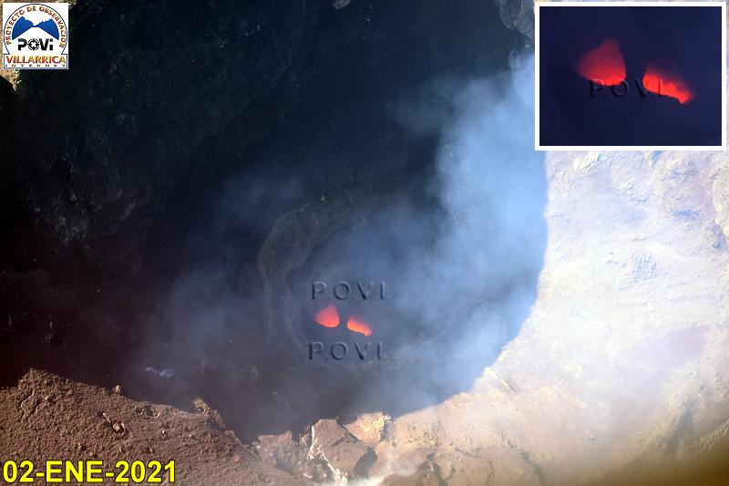 |
Figure 111. Webcam image of two incandescent vents at Villarrica on 2 January 2021. A bridge of solidified lava separates the two sections and extends across the active lava lake. Courtesy of POVI. |
Activity during February continued to decrease compared to the previous months and consisted of primarily white gas-and-steam plumes, nighttime crater incandescence, and SO2 plumes. On 10 February dense, white gas-and-steam plumes rose 700 m above the crater. During 1-15 February, the average value of SO2 plumes was 181 tons/day with a maximum daily value of 369 tons/day on 2 February. Long-period earthquakes were recorded by the seismic network at 1146 and 1156 on 16 February with an associated explosion that generated ash plumes 160 m above the crater that drifted NW and 280 m that drifted NE, respectively. During 16-28 February white gas-and-steam plumes rose to a high of 780 m above the crater; SO2 plumes were an average value of 402 tons/day with a maximum daily value of 1,026 tons/day on 21 February.
Low-power thermal activity was detected during September 2020 through January 2021, according to the MIROVA Log Radiative Power graph using MODIS infrared satellite information (figure 112). Three thermal anomalies were recorded in September, one in October, and four in November; a single stronger anomaly was observed in early November. The number of anomalies increased in late December through late January 2021, though they remained low in power. On clear weather days, a strong thermal anomaly in the summit crater was visible in Sentinel-2 thermal satellite imagery during each month of the reporting period; in February, the strength of the anomaly had slightly decreased compared to previous months (figure 113).
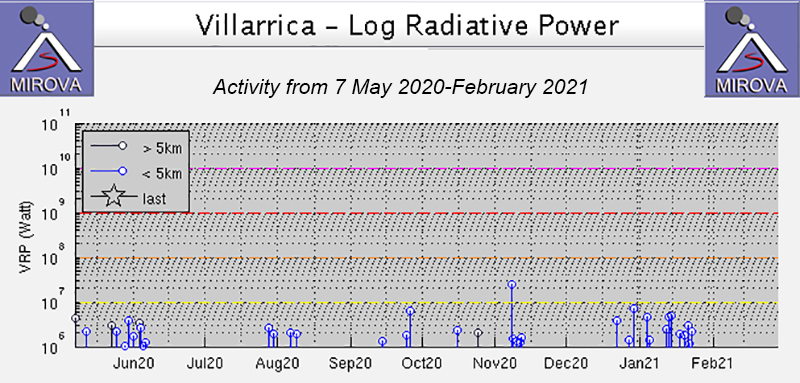 |
Figure 112. Low-power thermal anomalies were detected in the MIROVA graph (Log Radiative Power) at Villarrica during September 2020 through late January 2021. A pulse of thermal anomalies was recorded during late December 2020 through late January 2021 compared to the previous month but remained low in power. Courtesy of MIROVA. |
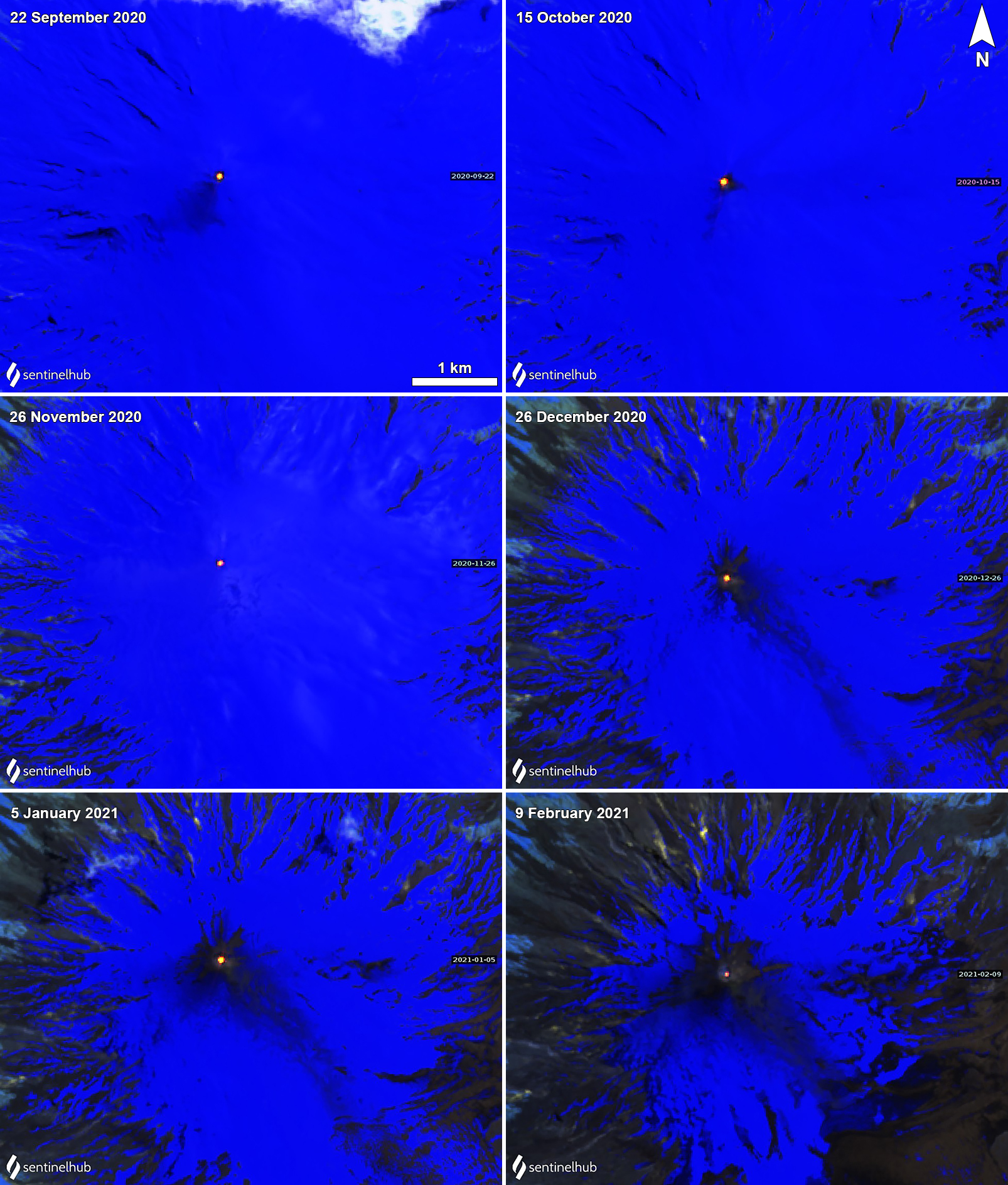 |
Figure 113. Sentinel-2 thermal satellite images showing strong thermal anomalies on clear weather days in the summit crater of Villarrica each month from September 2020 through February 2021. The strength of the thermal anomaly in February decreased slightly compared to previous months. Sentinel-2 satellite images with “Atmospheric penetration” (bands 12, 11, 8A) rendering. Courtesy of Sentinel Hub Playground. |
Information Contacts: Servicio Nacional de Geología y Minería (SERNAGEOMIN), Observatorio Volcanológico de Los Andes del Sur (OVDAS), Avda Sta María No. 0104, Santiago, Chile (URL: http://www.sernageomin.cl/); Proyecto Observación Villarrica Internet (POVI) (URL: http://www.povi.cl/); Buenos Aires Volcanic Ash Advisory Center (VAAC), Servicio Meteorológico Nacional-Fuerza Aérea Argentina, 25 de mayo 658, Buenos Aires, Argentina (URL: http://www.smn.gov.ar/vaac/buenosaires/inicio.php); MIROVA (Middle InfraRed Observation of Volcanic Activity), a collaborative project between the Universities of Turin and Florence (Italy) supported by the Centre for Volcanic Risk of the Italian Civil Protection Department (URL: http://www.mirovaweb.it/); Sentinel Hub Playground (URL: https://www.sentinel-hub.com/explore/sentinel-playground).
Activity declines; thermal anomalies persist during March-August 2021
Eruptions documented at Chile's Villarrica since 1558 have consisted largely of mild-to-moderate explosive activity with occasional lava effusion. An intermittently active lava lake at the summit has been the source of Strombolian activity, incandescent ejecta, and thermal anomalies for several decades; the current eruption has been ongoing since December 2014. Continuing low-level activity during March-August 2021 is covered in this report, with information provided by the Southern Andes Volcano Observatory (Observatorio Volcanológico de Los Andes del Sur, OVDAS), part of Chile's National Service of Geology and Mining (Servicio Nacional de Geología y Minería, SERNAGEOMIN), and Projecto Observación Villarrica Internet (POVI), part of the Fundacion Volcanes de Chile, a private research group that studies volcanoes across Chile. Sentinel satellite imagery also provided valuable data.
Activity decreased at Villarrica during March-August 2021, with no explosions reported, and rare incandescence at night. Low levels of seismicity, emissions, SO2, and thermal activity led SERNAGEOMIN to lower the Alert Level from Yellow to Green (on a 4-Level scale) in mid-April, and reduce the warning area to 100 m around the summit crater. They reported that analysis of satellite data in late February 2021 indicated that the surface of the lava lake was about 70-80 m below the crater rim. Persistent weak thermal anomalies in satellite data suggested that the lava lake remained at a deep level throughout the period.
Incandescence at night was reported once during the first half of March, and then not again through August. The number of LP seismic events decreased steadily each month from 6,986 events recorded during March to 172 events recorded during August 2021. Tremor and acoustic signals remained low, and VT seismic events were intermittent with six reported in early March, one or two each month during April-June, 4 in July, and 11 in August. Emissions were white, of variable intensity, and with little or no particulate material. Plumes reached about 1,000 m above the crater most months, dropping to less than 600 m during July and August. Thermal anomalies in Sentinel-2 satellite data were the only consistent evidence of activity throughout the period; anomalies were present in all clear satellite images. The intensity of the anomalies varied, and occasional steam plumes were also present (figure 114). A single series of thermal images from the POVI infrared webcam on 7 August was consistent with the interpretation of the deep level of the lava lake within the crater (figure 115).
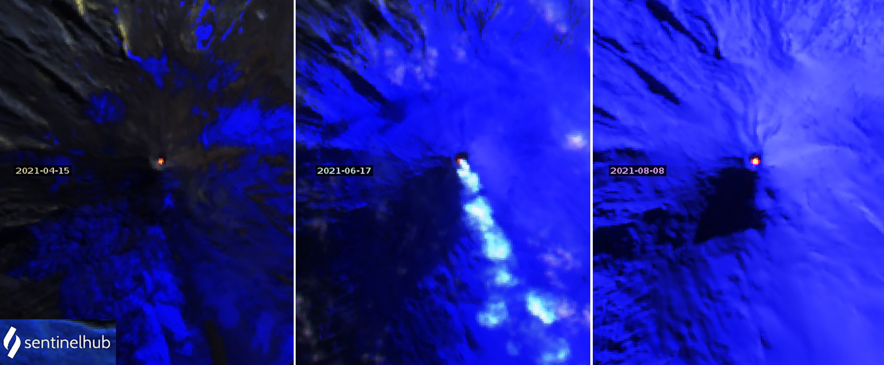 |
Figure 114. Thermal anomalies of varying intensity appeared in all clear Sentinel-2 satellite images of Villarrica during March-August 2021. A weak anomaly on 15 April (left), a steam plume with an anomaly on 17 June (center), and a bright anomaly on 8 August (right) show the range of values. Images use Atmospheric penetration rendering (bands 12, 11, 8a). Courtesy of Sentinel Hub Playground. |
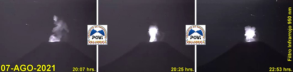 |
Figure 115. Low levels of incandescence recorded by the POVI webcam at Villarrica on 7 August 2021 were characteristic of the lava lake surface being located near the bottom of the crater. Courtesy of POVI. |
Information Contacts: Servicio Nacional de Geología y Minería (SERNAGEOMIN), Observatorio Volcanológico de Los Andes del Sur (OVDAS), Avda Sta María No. 0104, Santiago, Chile (URL: http://www.sernageomin.cl/); Proyecto Observación Villarrica Internet (POVI) (URL: http://www.povi.cl/); Sentinel Hub Playground (URL: https://www.sentinel-hub.com/explore/sentinel-playground).
Gas-and-steam emissions, seismicity, and crater incandescence during September 2021-February 2022
Villarrica has had documented eruptions dating back to 1558, which have consisted largely of mild-to-moderate explosive activity and occasional lava effusions. Its currently active cone has a 2-km-wide caldera at its base. The current eruption period has been ongoing since December 2014 and more recently has been characterized by low-level activity of thermal anomalies, gas-and-steam emissions, and sulfur dioxide emissions. This reporting period of September 2021 through February 2022 continues this pattern of low-level activity. Information for this report primarily comes from the Southern Andes Volcano Observatory (Observatorio Volcanológico de Los Andes del Sur, OVDAS), part of Chile's National Service of Geology and Mining (Servicio Nacional de Geología y Minería, SERNAGEOMIN) and satellite data.
Seismicity and thermal activity were relatively low in September. Continuous tremor, as many as 162 long period (LP), and 4 volcano-tectonic (VT) seismic events were recorded. Gas-and-steam emissions rose less than 500 m above the crater rim. A single thermal anomaly was visible above the volcano on 20 September, according to MIROVA data, and three anomalies were detected in Sentinel-2L2A satellite imagery on 7, 10, and 20 September (figure 116).
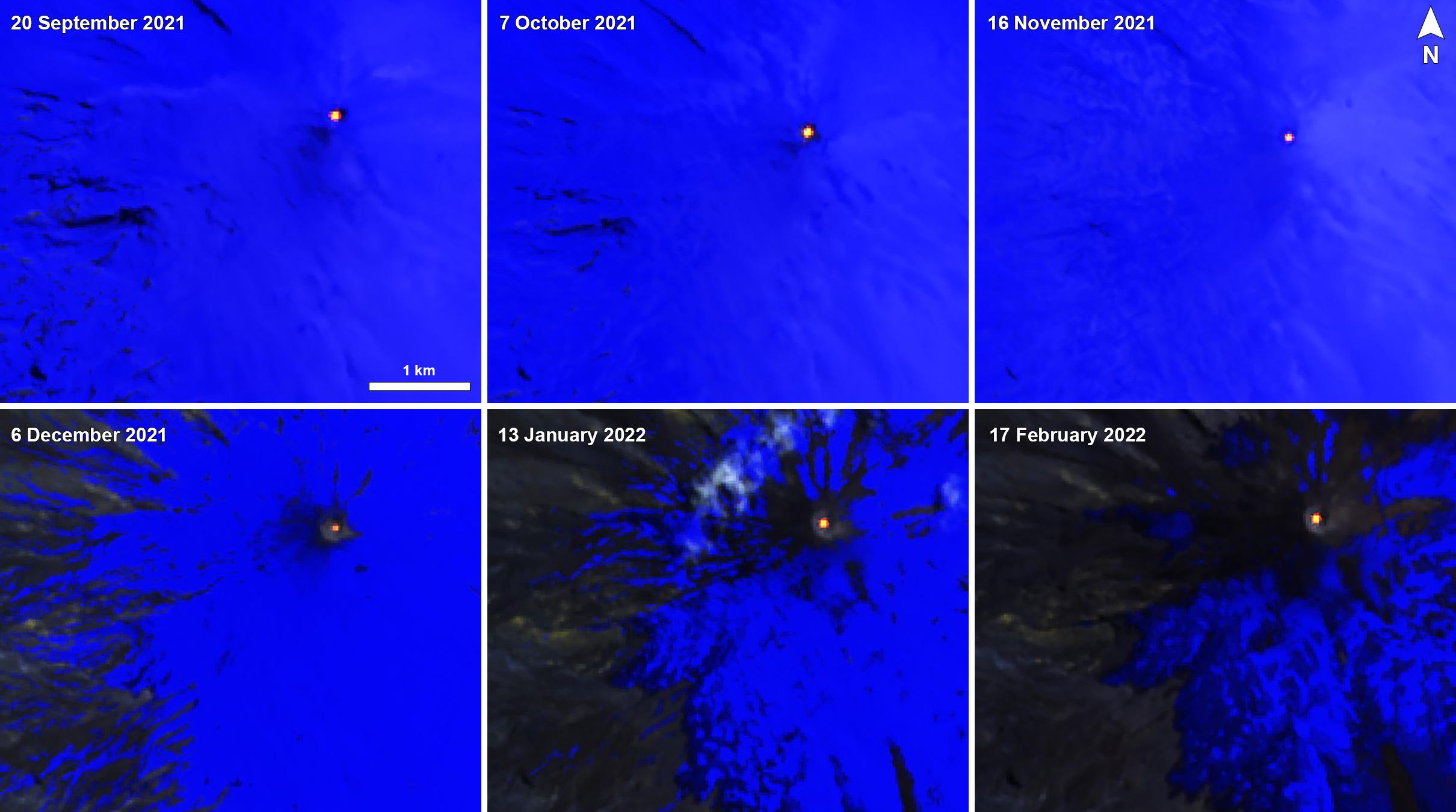 |
Figure 116. Intermittent thermal anomalies of varying intensity were visible in Sentinel-2 infrared satellite images of Villarrica during September 2021 through February 2022 on clear weather days. Images use Atmospheric penetration rendering (bands 12, 11, 8a). Courtesy of Sentinel Hub Playground. |
The number of LP-type events increased during October; as many as 2,142 were detected, in addition to 5 VT-type events. White gas-and-steam emissions of varying intensities throughout the month rose 1 km above the crater rim. MIROVA reported only one thermal anomaly, on 26 October, and Sentinel-2L2A imagery showed six anomalies on 7, 10, 12, 17, 27, and 30 October, according to SERNAGEOMIN (figure 116).
LP, tremor (TR), and VT-type seismic events were detected during November; about 504 LP and 88 VT-type earthquakes were recorded. The highest magnitude earthquake was 3.4, detected on 28 November about 10.8 km ESE of the crater. Throughout the month, gas-and-steam emissions rose less than 500 m above the crater rim. According to a notice from the Buenos Aires VAAC, an ash plume rose to 3.4 km altitude and drifted SE on 6 November. Analysis of Sentinel-2L2A satellite images showed nine thermal anomalies that occurred on 1, 6, 11, 16,19, 21, 24, 26, and 29 November (figure 116).
The number of LP earthquakes increased during December. About 2,888 LP earthquakes were recorded over the month, in addition to as many as 614 TR-type events. Gas-and-steam emissions persisted, rising less than 500 m above the crater rim. According to data from Sentinel-2L2A satellite imagery, ten thermal anomalies were visible in the crater on 4, 9, 14, 16, 19, 21, 24, 26, 29, and 31 December. SERNAGEOMIN used equipment for Differential Absorption Optical Spectroscopy (DOAS) to measure an average sulfur dioxide value of 412 and 608 t/d on 28 and 30 December, respectively.
During January 2022, LP and TR-type seismicity persisted, the latter of which presented an energy value (RSAM) between 0.1 and 0.4 units. About 3,766 earthquakes were detected, most of which were LP type, 53 were TR-type events, and five were VT-type events. Consistent gas-and-steam emissions rose to a maximum height of 540 m on 6 January. Based on DOAS measurements of sulfur dioxide emissions, an average value of 595 t/d was recorded, with a daily maximum value of 1,763 t/d on 19 January. Sentinel-2L2A satellite images showed a total of 8 thermal hotspots within the crater on 5, 8, 10, 13, 15, 25, 28, and 30 January (figure 116).
Seismicity in February was considered low, with the RSAM units measuring between 0.2 and 0.5. About 2,811 LP-type, 4 TR-type, and 1 VT-type seismic events were detected. The average value of sulfur dioxide emissions was 451 t/d, with a daily maximum value of 774 t/d on 15 February. On 2 February an ash plume rose to 2.7-4.6 km altitude and drifted E at 1050, based on data from two webcam images and information from SERNAGEOMIN. By 1130 the plume was barely visible in satellite images. Webcam images showed continuous gas-and-steam emissions with sporadic puffs of ash rising as high as 4.9 km altitude, although by 2330, the ash was no longer visible. There were seven thermal anomalies detected during the month on 2, 4, 7, 9, 12, 14, and 17 February (figure 116). Low-intensity incandescence was visible from 12 to 15 February. Gas-and-steam emissions persisted, with a maximum height of 520 m above the crater rim on 21 February.
Information Contacts: Servicio Nacional de Geología y Minería (SERNAGEOMIN), Observatorio Volcanológico de Los Andes del Sur (OVDAS), Avda Sta María No. 0104, Santiago, Chile (URL: http://www.sernageomin.cl/); Buenos Aires Volcanic Ash Advisory Center (VAAC), Servicio Meteorológico Nacional-Fuerza Aérea Argentina, 25 de mayo 658, Buenos Aires, Argentina (URL: http://www.smn.gov.ar/vaac/buenosaires/inicio.php); MIROVA (Middle InfraRed Observation of Volcanic Activity), a collaborative project between the Universities of Turin and Florence (Italy) supported by the Centre for Volcanic Risk of the Italian Civil Protection Department (URL: http://www.mirovaweb.it/); Sentinel Hub Playground (URL: https://www.sentinel-hub.com/explore/sentinel-playground).
Ongoing seismicity, gas-and-steam emissions, and crater incandescence during March-September 2022
Villarrica, located in central Chile, consists of a presently active 2-km-wide caldera that formed about 3,500 years ago, located at the base of the active cone. Eruptions dating back to 1558 have been characterized by mild-to-moderate explosive activity with occasional lava effusion. The current eruption period began in December 2014 and has recently included low-level activity and incandescence from lava in in the summit crater, gas-and-steam emissions, and sulfur dioxide emissions. This reporting period covers activity during March-September 2022 describing seismicity, gas-and-steam plumes, and nighttime incandescence. Information for this report primarily comes from the Southern Andes Volcano Observatory (Observatorio Volcanológico de Los Andes del Sur, OVDAS), part of Chile's National Service of Geology and Mining (Servicio Nacional de Geología y Minería, SERNAGEOMIN) and satellite data.
Seismicity during March 2022 consisted of a continuous tremor signal with relatively low RSAM energy values. There were three volcano-tectonic (VT) seismic events, as many as 4,774 long-period (LP) events, and 19 tremor (TR) events were recorded. Occasional gas-and-steam emissions rose as high as 900 m on 11 March. Sulfur dioxide data was obtained by the Differential Absorption Optical Spectroscopy Equipment (DOAS), corresponding to the Los Nevados and Tralco stations that were installed 10 km ENE and 6 km ESE from the active crater, respectively. The average value of sulfur dioxide emissions was 391 ± 107 tons per day (t/d); the maximum daily value was 826 t/d on 20 March; according to SERNAGEOMIN, these values were relatively low. An analysis of Sentinel-2 satellite images showed that six thermal anomalies occurred in the crater on 4, 9, 11, 16, 24, and 31 March.
Similar low activity continued during April. The continuous tremor signal was detected, and there were seven VT-type seismic events associated with rock fracturing events, 9,993 LP-type events that were associated with fluid dynamics in the volcanic system, and 89 TR-type events. The DOAS data showed that the average value of sulfur dioxide emissions was 337 ± 72 t/d, with a maximum daily value of 621 t/d on 5 April. Thermal anomalies were visible in Sentinel-2 satellite images on 8, 13, 15, 18, 28, and 30 April. Intermittent gas-and-steam emissions rose as high as 1.1 km on 16 April.
Low seismicity during May consisted of a continuous tremor, three VT-type events, 7,287 LP-type events, and 335 TR-type events. Gas-and-steam emissions continued to occur, rising as high as 940 m on 10 May. The average value of sulfur dioxide emissions decreased to 260 ± 45 t/d compared to the previous month, with a maximum daily value of 715 t/d on 7 May. There were seven thermal anomalies visible in Sentinel-2 satellite images on 3, 5, 10, 13, 15, 18, and 25 May. Nighttime incandescence was observed beginning on 25 May and continued through the end of the month (figure 117).
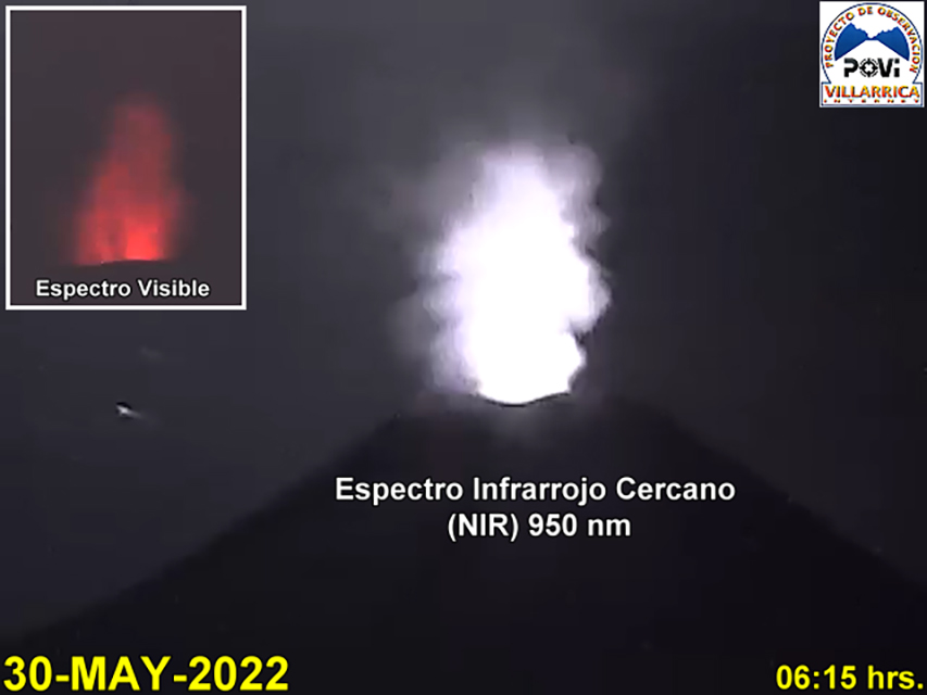 |
Figure 117. Near-infrared webcam image showing nighttime crater incandescence at Villarrica at 0615 on 30 May 2022. Courtesy of POVI. |
During June continuous tremor, 12 VT-type events, 6,411 LP-type events, and 188 TR-type events were detected throughout the month. Due to weather conditions, sulfur dioxide was only measured on one day; on 25 June the average value was 1,075 t/d. Three thermal anomalies were detected in Sentinel-2 satellite images on 9, 12, and 17 June. Based on surveillance cameras, frequent gas-and-steam emissions rose as high as 800 m on 21 June. Nighttime incandescence was notably strong during 25 June.
Seismicity persisted during July; a continuous tremor signal was detected, in addition to 15 VT-type seismic events, 5,720 LP-type events, and 12 TR-type events. Surveillance cameras recorded regular degassing in the area, and a 1-km-high gas-and-steam column was reported on 14 July. Nighttime incandescence was recorded throughout the month. Sulfur dioxide measurements were taken on three days of the month due to weather conditions; on 31 July the average value was 3,668 t/d, which SERNAGEOMIN reported was within normal levels. Two thermal anomalies were detected in the crater area on 14 and 29 July.
Seismic activity during August was characterized by 9 VT-type events, 1,449 LP-type events, and 2 TR-type events. There was a notable increase in the average value of sulfur dioxide emissions of 2,524 ± 386 t/d, with a maximum daily value of 5,304 t/d on 11 August. According to SERNAGEOMIN, these values were above the levels that are considered normal. The Sentinel-2 satellite captured a total of 5 thermal anomalies in imagery on 1, 3, 8, 21, and 29 August. Constant degassing persisted, rising as high as 340 m on 28 August. During clear weather days, nighttime incandescence was also observed.
Similar activity continued during September. Seismicity was characterized by 11 VT-type events, 1,718 LP-type events, and 2 TR-type events throughout the month. The average value of sulfur dioxide emissions was 2,010 ± 432 t/d, with a maximum daily value of 4,806 t/d on 5 September; these values were still considered above average. There was a total of six thermal anomalies detected in Sentinel-2 satellite imagery on 2, 5, 10, 12, 27, and 30 September. Frequent gas-and-steam emissions were captured in webcam images, with a maximum plume rising as high as 400 m above the crater on 24 September. Nighttime incandescence was also visible on clear weather days. During late September gas-and-steam emissions occasionally contained some amount of pyroclasts, which were deposited near the crater rim.
Infrared MODIS satellite data processed by MIROVA (Middle InfraRed Observation of Volcanic Activity) detected low thermal activity once during early April, twice during mid-and-late May, seven times during August, and five times during September (figure 118). Small but consistent thermal anomalies were visible at the crater in Sentinel-2 infrared satellite imagery throughout the reporting period (figure 119).
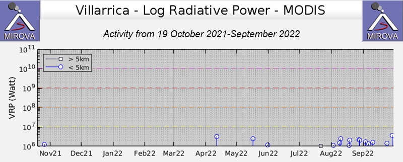 |
Figure 118. Graph of low-power thermal anomalies (Log Radiative Power) at Villarrica from the MIROVA system during October 2021-September 2022. A single thermal anomaly was detected during early April, two during mid-to-late May, seven times during August, and five times during September. Courtesy of MIROVA. |
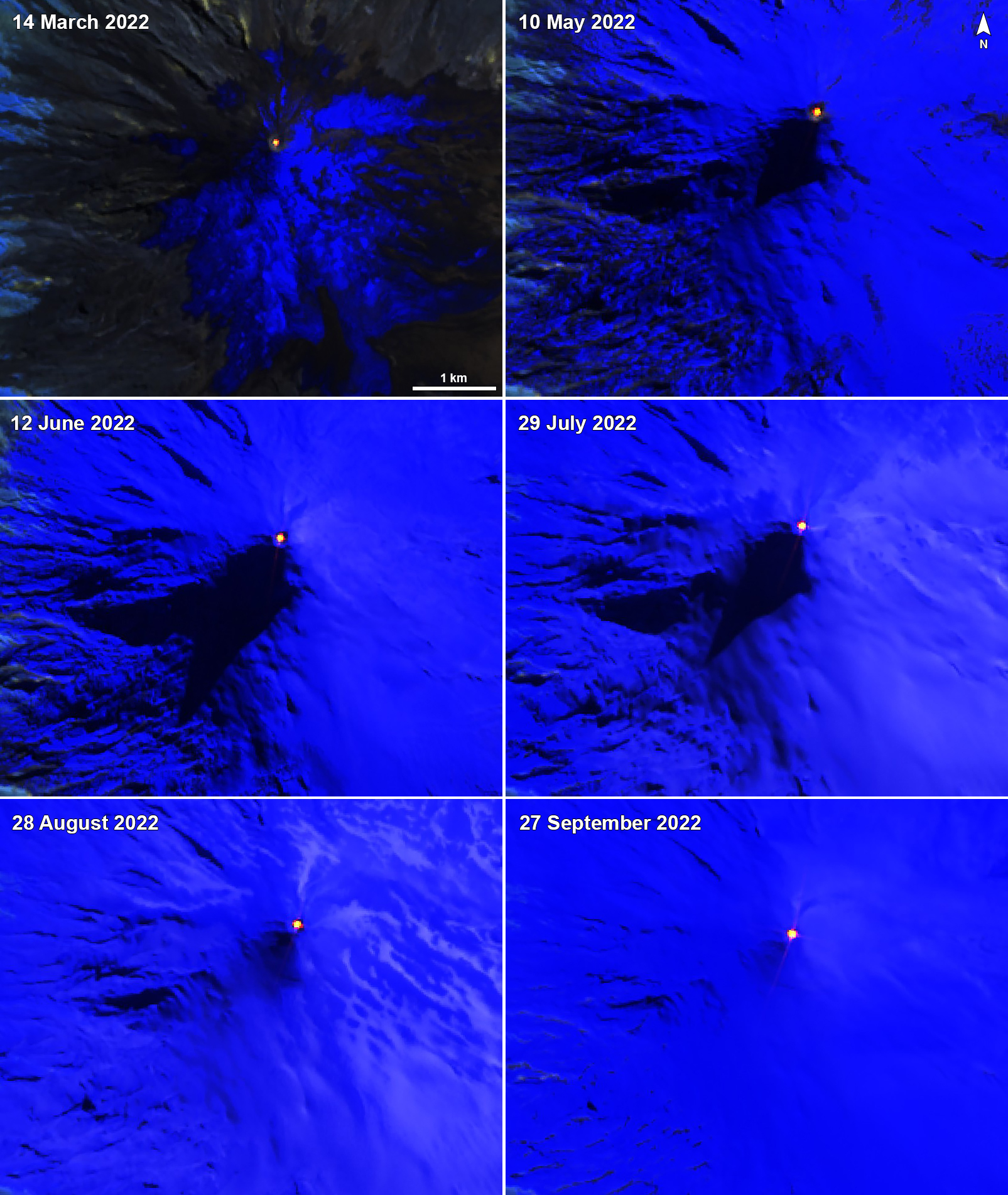 |
Figure 119. Consistent thermal anomalies in the summit crater of Villarrica were visible in Sentinel-2 infrared satellite images on 14 March 2022 (top left), 10 May 2022 (top right), 12 June 2022 (middle left), 29 July 2022 (middle right), 28 August 2022 (bottom left), and 27 September 2022 (bottom right) on clear weather days. Images use Atmospheric penetration rendering (bands 12, 11, 8a). Courtesy of Sentinel Hub Playground. |
Information Contacts: Servicio Nacional de Geología y Minería (SERNAGEOMIN), Observatorio Volcanológico de Los Andes del Sur (OVDAS), Avda Sta María No. 0104, Santiago, Chile (URL: http://www.sernageomin.cl/); Proyecto Observación Villarrica Internet (POVI) (URL: http://www.povi.cl/); MIROVA (Middle InfraRed Observation of Volcanic Activity), a collaborative project between the Universities of Turin and Florence (Italy) supported by the Centre for Volcanic Risk of the Italian Civil Protection Department (URL: http://www.mirovaweb.it/); Sentinel Hub Playground (URL: https://www.sentinel-hub.com/explore/sentinel-playground).
Nighttime crater incandescence, ash emissions, and seismicity during October 2022-March 2023
Villarrica, located in central Chile, consists of a 2-km-wide caldera that formed about 3,500 years ago, located at the base of the presently active cone. Historical eruptions date back to 1558 and have been characterized by mild-to-moderate explosive activity with occasional lava effusions. The current eruption period began in December 2014 and has recently consisted of ongoing seismicity, gas-and-steam emissions, and thermal activity (BGVN 47:10). This report covers activity during October 2022 through March 2023 and describes Strombolian explosions, ash emissions, and crater incandescence. Information for this report primarily comes from the Southern Andes Volcano Observatory (Observatorio Volcanológico de Los Andes del Sur, OVDAS), part of Chile's National Service of Geology and Mining (Servicio Nacional de Geología y Minería, SERNAGEOMIN) and satellite data.
Seismicity during October consisted of discrete long-period (LP)-type events, tremor (TR), and volcano-tectonic (VT)-type events. Webcam images showed eruption plumes rising as high as 460 m above the crater rim; plumes deposited tephra on the E, S, and SW flanks within 500 m of the crater on 2, 18, 23, and 31 October. White gas-and-steam emissions rose 80-300 m above the crater accompanied by crater incandescence during 2-3 October. There was a total of 5 VT-type events, 10,625 LP-type events, and 2,232 TR-type events detected throughout the month. Sulfur dioxide data was obtained by the Differential Absorption Optical Spectroscopy Equipment (DOAS) installed 6 km in an ESE direction. The average value of the sulfur dioxide emissions was 535 ± 115 tons per day (t/d); the highest daily maximum was 1,273 t/d on 13 October. These values were within normal levels and were lower compared to September. During the night of 3-4 October Strombolian activity ejected blocks as far as 40 m toward the NW flank. Small, gray-brown ash pulses rose 60 m above the crater accompanied white gas-and-steam emissions that rose 40-300 m high during 4-5 October. In addition, crater incandescence and Strombolian explosions that ejected blocks were reported during 4-5 and 9-11 October. Based on satellite images from 12 October, ballistic ejecta traveled as far as 400 m and the resulting ash was deposited 3.2 km to the E and SE and 900 m to the NW.
Satellite images from 14 October showed an active lava lake that covered an area of 36 square meters in the E part of the crater floor. There was also evidence of a partial collapse (less than 300 square meters) at the inner SSW crater rim. POVI posted an 18 October photo that showed incandescence above the crater rim, noting that crater incandescence was visible during clear weather nights. In addition, webcam images at 1917 showed lava fountaining and Strombolian explosions; tourists also described seeing splashes of lava ejected from a depth of 80 m and hearing loud degassing sounds. Tephra deposits were visible around the crater rim and on the upper flanks on 24 October. On 25 October SERNAGEOMIN reported that both the number and amplitude of LP earthquakes had increased, and continuous tremor also increased; intense crater incandescence was visible in satellite images. On 31 October Strombolian explosions intensified and ejected material onto the upper flanks.
Activity during November consisted of above-baseline seismicity, including intensifying continuous tremor and an increase in the number of LP earthquakes. On 1 November a lava fountain was visible rising above the crater rim. Nighttime crater incandescence was captured in webcam images on clear weather days. Strombolian explosions ejected incandescent material on the NW and SW flanks during 1, 2, and 6-7 November. POVI reported that the width of the lava fountains that rose above the crater rim on 2 November suggested that the vent on the crater floor was roughly 6 m in diameter. Based on reports from observers and analyses of satellite imagery, material that was deposited on the upper flanks, primarily to the NW, consisted of clasts up to 20 cm in diameter. During an overflight on 19 November SERNAGEOMIN scientists observed a cone on the crater floor with an incandescent vent at its center that contained a lava lake. Deposits of ejecta were also visible on the flanks. That same day a 75-minute-long series of volcano-tectonic earthquakes was detected at 1940; a total of 21 events occurred 7.8 km ESE of the crater. Another overflight on 25 November showed the small cone on the crater floor with an incandescent lava lake at the center; the temperature of the lava lake was 1,043 °C, based data gathered during the overflight.
Similar seismicity, crater incandescence, and gas-and-steam emissions continued during December. On 1 December incandescent material was ejected 80-220 m above the crater rim. During an overflight on 6 December, intense gas-and-steam emissions from the lava lake was reported, in addition to tephra deposits on the S and SE flanks as far as 500 m from the crater. During 7-12 December seismicity increased slightly and white, low-altitude gas-and-steam emissions and crater incandescence were occasionally visible. On 24 December at 0845 SERNAGEOMIN reported an increase in Strombolian activity; explosions ejected material that generally rose 100 m above the crater, although one explosion ejected incandescent tephra as far as 400 m from the crater onto the SW flank. According to POVI, 11 explosions ejected incandescent material that affected the upper SW flank between 2225 on 25 December to 0519 on 26 December. POVI recorded 21 Strombolian explosions that ejected incandescent material onto the upper SW flank from 2200 on 28 December to 0540 on 29 December. More than 100 Strombolian explosions ejected material onto the upper W and NW flanks during 30-31 December. On 30 December at 2250 an explosion was detected that generated an eruptive column rising 120 m above the crater and ejecting incandescent material 300 m on the NW flank (figure 120). Explosions detected at 2356 on 31 December ejected material 480 m from the crater rim onto the NW flank and at 0219 material was deposited on the same flank as far as 150 m. Both explosions ejected material as high as 120 m above the crater rim.
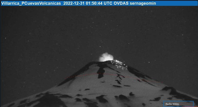 |
Figure 120. Webcam image of a Strombolian explosion at Villarrica on 30 December 2022 (local time) that ejected incandescent material 300 m onto the NW flank, accompanied by emissions and crater incandescence. Courtesy of SERNAGEOMIN (Reporte Especial de Actividad Volcanica (REAV), Region De La Araucania y Los Rios, Volcan Villarrica, 30 de diciembre de 2022, 23:55 Hora local). |
During January 2023, Strombolian explosions and lava fountaining continued mainly in the crater, ejecting material 100 m above the crater. Gas-and-steam emissions rose 40-260 m above the crater and drifted in different directions, and LP-type events continued. Emissions during the night of 11 January including some ash rose 80 m above the crater and as far as 250 m NE flank. POVI scientists reported about 70 lava fountaining events from 2130 on 14 January to 0600 on 15 January. At 2211 on 15 January there was an increase in frequency of Strombolian explosions that ejected incandescent material 60-150 m above the crater. Some ashfall was detected around the crater. POVI noted that on 19 January lava was ejected as high as 140 m above the crater rim and onto the W and SW flanks. Explosion noises were heard on 19 and 22 January in areas within a radius of 10 km. During 22-23 January Strombolian explosions ejected incandescent material 60-100 m above the crater that drifted SE. A seismic event at 1204 on 27 January was accompanied by an ash plume that rose 220 m above the crater and drifted E (figure 121); later that same day at 2102 an ash plume rose 180 m above the crater and drifted E.
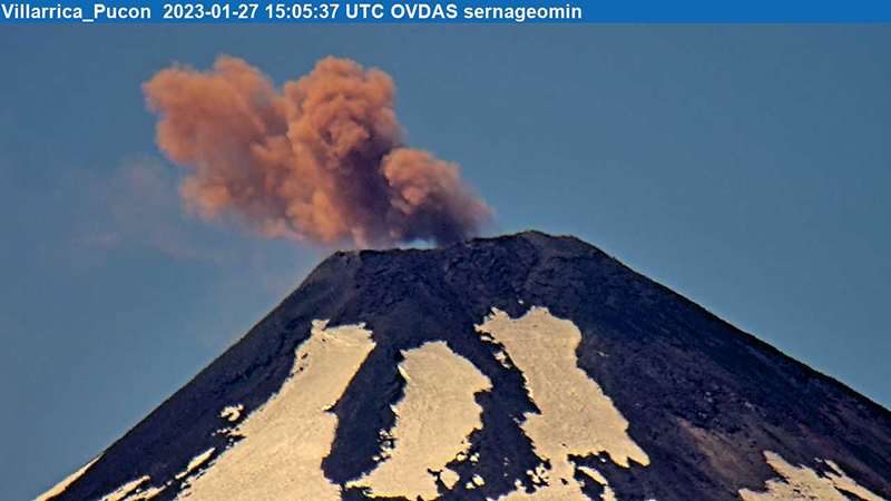 |
Figure 121. Webcam image of an ash plume at Villarrica on 27 January rising 220 m above the crater and drifting E. Courtesy of SERNAGEOMIN (Reporte Especial de Actividad Volcanica (REAV), Region De La Araucania y Los Rios, Volcan Villarrica, 27 de enero de 2023, 12:35 Hora local). |
Seismicity, primarily characterized by LP-type events, and Strombolian explosions persisted during February and March. POVI reported that three explosions were heard during 1940-1942 on 6 February, and spatter was seen rising 30 m above the crater rim hours later. On 9 February lava fountains were visible rising 50 m above the crater rim. On 17 February Strombolian explosions ejected material 100 m above the crater rim and onto the upper SW flank. Webcam images from 20 February showed two separate fountains of incandescent material, which suggested that a second vent had opened to the E of the first vent. Spatter was ejected as high as 80 m above the crater rim and onto the upper NE flank. A sequence of Strombolian explosions was visible from 2030 on 20 February to 0630 on 21 February. Material was ejected as high as 80 m above the crater rim and onto the upper E flank. LP-type earthquakes recorded 1056 and at 1301 on 27 February were associated with ash plumes that rose 300 m above the crater and drifted NE (figure 122). Crater incandescence above the crater rim was observed in webcam images on 13 March, which indicated Strombolian activity. POVI posted a webcam image from 2227 on 18 March showing Strombolian explosions that ejected material as high as 100 m above the crater rim. Explosions were heard up to 8 km away. On 19 March at 1921 an ash emission rose 340 m above the crater and drifted NE. On 21 and 26 March Strombolian explosions ejected material 100 and 110 m above the crater rim, respectively. On 21 March Strombolian explosions ejected material 100 m above the crater rim. Low-intensity nighttime crater incandescence was detected by surveillance cameras on 24 March.
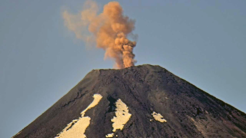 |
Figure 122. Photo of an ash plume rising 300 m above the crater of Villarrica and drifting NE on 27 February 2023. Courtesy of SERNAGEOMIN (Reporte Especial de Actividad Volcanica (REAV), Region De La Araucania y Los Rios, Volcan Villarrica, 27 de febrero de 2023, 11:10 Hora local). |
Infrared MODIS satellite data processed by MIROVA (Middle InfraRed Observation of Volcanic Activity) detected an increase in thermal activity during mid-November, which corresponds to sustained Strombolian explosions, lava fountaining, and crater incandescence (figure 123). This activity was also consistently captured on clear weather days throughout the reporting period in Sentinel-2 infrared satellite images (figure 124).
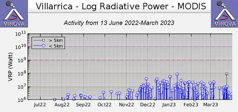 |
Figure 123. Low-power thermal anomalies were detected during August through October 2022 at Villarrica, based on this MIROVA graph (Log Radiative Power). During mid-November, the power and frequency of the anomalies increased and remained at a consistent level through March 2023. Thermal activity consisted of Strombolian explosions, lava fountains, and crater incandescence. Courtesy of MIROVA. |
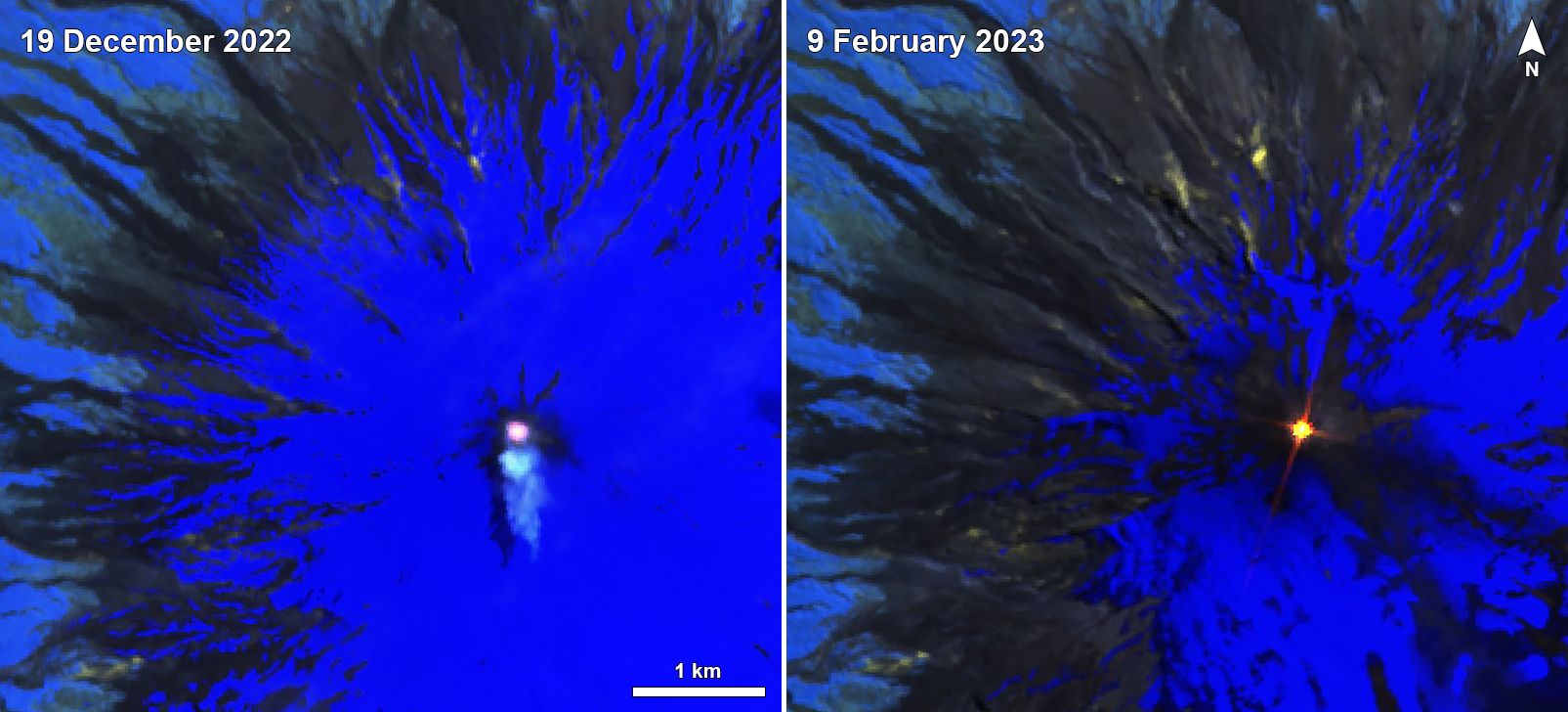 |
Figure 124. Consistent bright thermal anomalies were visible at the summit crater of Villarrica in Sentinel-2 infrared satellite images throughout the reporting period, as shown here on 19 December 2022 (left) and 9 February 2023 (right). Occasional gas-and-steam emissions also accompanied the thermal activity. Images use Atmospheric penetration rendering (bands 12, 11, 8a). Courtesy of Sentinel Hub Playground. |
Information Contacts: Servicio Nacional de Geología y Minería (SERNAGEOMIN), Observatorio Volcanológico de Los Andes del Sur (OVDAS), Avda Sta María No. 0104, Santiago, Chile (URL: http://www.sernageomin.cl/); Proyecto Observación Villarrica Internet (POVI) (URL: http://www.povi.cl/); MIROVA (Middle InfraRed Observation of Volcanic Activity), a collaborative project between the Universities of Turin and Florence (Italy) supported by the Centre for Volcanic Risk of the Italian Civil Protection Department (URL: http://www.mirovaweb.it/); Sentinel Hub Playground (URL: https://www.sentinel-hub.com/explore/sentinel-playground).
Strombolian activity, gas-and-ash emissions, and crater incandescence during April-September 2023
Villarrica, in central Chile, consists of a 2-km-wide caldera that formed about 3,500 years ago and is located at the base of the presently active cone at the NW margin of a 6-km-wide caldera. Historical eruptions eruptions date back to 1558 and have been characterized by mild-to-moderate explosive activity with occasional lava effusions. The current eruption period began in December 2014 and has recently consisted of nighttime crater incandescence, ash emissions, and seismicity (BGVN 48:04). This report covers activity during April through September 2023 and describes occasional Strombolian activity, gas-and-ash emissions, and nighttime crater incandescence. Information for this report primarily comes from the Southern Andes Volcano Observatory (Observatorio Volcanológico de Los Andes del Sur, OVDAS), part of Chile's National Service of Geology and Mining (Servicio Nacional de Geología y Minería, SERNAGEOMIN) and satellite data.
Seismicity during April consisted of long period (LP) events and tremor (TRE); a total of 9,413 LP-type events and 759 TR-type events were detected throughout the month. Nighttime crater incandescence persisted and was visible in the degassing column. Sulfur dioxide data was obtained using Differential Absorption Optical Spectroscopy Equipment (DOAS) that showed an average value of 1,450 ± 198 tons per day (t/d) during 1-15 April and 1,129 ± 201 t/d during 16-30 April, with a maximum daily value of 2,784 t/d on 9 April. Gas-and-steam emissions of variable intensities rose above the active crater as high as 1.3 km above the crater on 13 April. Strombolian explosions were not observed and there was a slight decrease in the lava lake level.
There were 14,123 LP-type events and 727 TR-type events detected during May. According to sulfur dioxide measurements taken with DOAS equipment, the active crater emitted an average value of 1,826 ± 482 t/d during 1-15 May and 912 ± 41 t/d during 16-30 May, with a daily maximum value of 5,155 t/d on 13 May. Surveillance cameras showed continuous white gas-and-steam emissions that rose as high as 430 m above the crater on 27 May. Nighttime incandescence illuminated the gas column less than 300 m above the crater rim was and no pyroclastic emissions were reported. A landslide was identified on 13 May on the E flank of the volcano 50 m from the crater rim and extending 300 m away; SERNAGEOMIN noted that this event may have occurred on 12 May. During the morning of 27 and 28 May minor Strombolian explosions characterized by incandescent ejecta were recorded at the crater rim; the last reported Strombolian explosions had occurred at the end of March.
Seismic activity during June consisted of five volcano-tectonic (VT)-type events, 21,606 LP-type events, and 2,085 TR-type events. The average value of sulfur dioxide flux obtained by DOAS equipment was 1,420 ± 217 t/d during 1-15 June and 2,562 ± 804 t/d, with a maximum daily value of 4,810 t/d on 17 June. White gas-and-steam emissions rose less than 480 m above the crater; frequent nighttime crater incandescence was reflected in the degassing plume. On 12 June an emission rose 100 m above the crater and drifted NNW. On 15 June one or several emissions resulted in ashfall to the NE as far as 5.5 km from the crater, based on a Skysat satellite image. Several Strombolian explosions occurred within the crater; activity on 15 June was higher energy and ejected blocks 200-300 m on the NE slope. Surveillance cameras showed white gas-and-steam emissions rising 480 m above the crater on 16 June. On 19 and 24 June low-intensity Strombolian activity was observed, ejecting material as far as 200 m from the center of the crater to the E.
During July, seismicity included 29,319 LP-type events, 3,736 TR-type events, and two VT-type events. DOAS equipment recorded two days of sulfur dioxide emissions of 4,220 t/d and 1,009 t/d on 1 and 13 July, respectively. Constant nighttime incandescence was also recorded and was particularly noticeable when accompanied by eruptive columns on 12 and 16 July. Minor explosive events were detected in the crater. According to Skysat satellite images taken on 12, 13, and 16 July, ashfall deposits were identified 155 m S of the crater. According to POVI, incandescence was visible from two vents on the crater floor around 0336 on 12 July. Gas-and-ash emissions rose as high as 1.2 km above the crater on 13 July and drifted E and NW. A series of gas-and-steam pulses containing some ash deposited material on the upper E flank around 1551 on 13 July. During 16-31 July, average sulfur dioxide emissions of 1,679 ± 406 t/d were recorded, with a maximum daily value of 2,343 t/d on 28 July. Fine ash emissions were also reported on 16, 17, and 23 July.
Seismicity persisted during August, characterized by 27,011 LP-type events, 3,323 TR-type events, and three VT-type events. The average value of sulfur dioxide measurements taken during 1-15 August was 1,642 ± 270 t/d and 2,207 ± 4,549 t/d during 16-31 August, with a maximum daily value of 3,294 t/d on 27 August. Nighttime crater incandescence remained visible in degassing columns. White gas-and-steam emissions rose 480 m above the crater on 6 August. According to a Skysat satellite image from 6 August, ash accumulation was observed proximal to the crater and was mainly distributed toward the E slope. White gas-and-steam emissions rose 320 m above the crater on 26 August. Nighttime incandescence and Strombolian activity that generated ash emissions were reported on 27 August.
Seismicity during September was characterized by five VT-type events, 12,057 LP-type events, and 2,058 TR-type events. Nighttime incandescence persisted. On 2 September an ash emission rose 180 m above the crater and drifted SE at 1643 (figure 125) and a white gas-and-steam plume rose 320 m above the crater. According to the Buenos Aires VAAC, periods of continuous gas-and-ash emissions were visible in webcam images from 1830 on 2 September to 0110 on 3 September. Strombolian activity was observed on 2 September and during the early morning of 3 September, the latter event of which generated an ash emission that rose 60 m above the crater and drifted 100 m from the center of the crater to the NE and SW. Ashfall was reported to the SE and S as far as 750 m from the crater. The lava lake was active during 3-4 September and lava fountaining was visible for the first time since 26 March 2023, according to POVI. Fountains captured in webcam images at 2133 on 3 September and at 0054 on 4 September rose as high as 60 m above the crater rim and ejected material onto the upper W flank. Sulfur dioxide flux of 1,730 t/d and 1,281 t/d was measured on 3 and 4 September, respectively, according to data obtained by DOAS equipment.
|
Figure 125. Webcam image of a gray ash emission rising above Villarrica on 2 September 2023 at 1643 (local time) that rose 180 m above the crater and drifted SE. Courtesy of SERNAGEOMIN (Reporte Especial de Actividad Volcanica (REAV), Region De La Araucania y Los Rios, Volcan Villarrica, 02 de septiembre de 2023, 17:05 Hora local). |
Strong Strombolian activity and larger gas-and-ash plumes were reported during 18-20 September. On 18 September activity was also associated with energetic LP-type events and notable sulfur dioxide fluxes (as high as 4,277 t/d). On 19 September Strombolian activity and incandescence were observed. On 20 September at 0914 ash emissions rose 50 m above the crater and drifted SSE, accompanied by Strombolian activity that ejected material less than 100 m SSE, causing fall deposits on that respective flank. SERNAGEOMIN reported that a Planet Scope satellite image taken on 20 September showed the lava lake in the crater, measuring 32 m x 35 m and an area of 0.001 km2. Several ash emissions were recorded at 0841, 0910, 1251, 1306, 1312, 1315, and 1324 on 23 September and rose less than 150 m above the crater. The sulfur dioxide flux value was 698 t/d on 23 September and 1,097 t/d on 24 September. On 24 September the Volcanic Alert Level (VAL) was raised to Orange (the third level on a four-color scale). SENAPRED maintained the Alert Level at Yellow (the middle level on a three-color scale) for the communities of Villarrica, Pucón (16 km N), Curarrehue, and Panguipulli.
During 24-25 September there was an increase in seismic energy (observed at TR-events) and acoustic signals, characterized by 1 VT-type event, 213 LP-type events, and 124 TR-type events. Mainly white gas-and-steam emissions, in addition to occasional fine ash emissions were recorded. During the early morning of 25 September Strombolian explosions were reported and ejected material 250 m in all directions, though dominantly toward the NW. On 25 September the average value of sulfur dioxide flux was 760 t/d. Seismicity during 25-30 September consisted of five VT-type events, 1,937 LP-type events, and 456 TR-type events.
During 25-29 September moderate Strombolian activity was observed and ejected material as far as the crater rim. In addition, ash pulses lasting roughly 50 minutes were observed around 0700 and dispersed ENE. During 26-27 September a TR episode lasted 6.5 hours and was accompanied by discrete acoustic signals. Satellite images from 26 September showed a spatter cone on the crater floor with one vent that measured 10 x 14 m and a smaller vent about 35 m NE of the cone. SERNAGEOMIN reported an abundant number of bomb-sized blocks up to 150 m from the crater, as well as impact marks on the snow, which indicated explosive activity. A low-altitude ash emission was observed drifting NW around 1140 on 28 September, based on webcam images. Between 0620 and 0850 on 29 September an ash emission rose 60 m above the crater and drifted NW. During an overflight taken around 1000 on 29 September scientists observed molten material in the vent, a large accumulation of pyroclasts inside the crater, and energetic degassing, some of which contained a small amount of ash. Block-sized pyroclasts were deposited on the internal walls and near the crater, and a distal ash deposit was also visible. The average sulfur dioxide flux measured on 28 September was 344 t/d. Satellite images taken on 29 September ashfall was deposited roughly 3 km WNW from the crater and nighttime crater incandescence remained visible. The average sulfur dioxide flux value from 29 September was 199 t/d. On 30 September at 0740 a pulsating ash emission rose 1.1 km above the crater and drifted NNW (figure 126). Deposits on the S flank extended as far as 4.5 km from the crater rim, based on satellite images from 30 September.
|
Figure 126. Webcam image of a gray ash plume rising 1.1 km above the crater of Villarrica at 0740 (local time) on 30 September 2023. Courtesy of SERNAGEOMIN (Reporte Especial de Actividad Volcanica (REAV), Region De La Araucania y Los Rios, Volcan Villarrica, 30 de septiembre de 2023, 09:30 Hora local). |
Infrared MODIS satellite data processed by MIROVA (Middle InfraRed Observation of Volcanic Activity) showed intermittent thermal activity during April through September, with slightly stronger activity detected during late September (figure 127). Small clusters of thermal activity were detected during mid-June, early July, early August, and late September. According to the MODVOLC thermal alert system, a total of four thermal hotspots were detected on 7 July and 3 and 23 September. This activity was also intermittently captured in infrared satellite imagery on clear weather days (figure 128).
|
Figure 127. Low-to-moderate power thermal anomalies were detected at Villarrica during April through September 2023, according to this MIROVA graph (Log Radiative Power). Activity was relatively low during April through mid-June. Small clusters of activity occurred during mid-June, early July, early August, and late September. Courtesy of MIROVA. |
|
Figure 128. Consistent bright thermal anomalies (bright yellow-orange) were visible at the summit crater of Villarrica in infrared (bands B12, B11, B4) satellite images, as shown on 17 June 2023 (top left), 17 July 2023 (top right), 6 August 2023 (bottom left), and 20 September 2023 (bottom right). Courtesy of Copernicus Browser. |
Information Contacts: Servicio Nacional de Geología y Minería (SERNAGEOMIN), Observatorio Volcanológico de Los Andes del Sur (OVDAS), Avda Sta María No. 0104, Santiago, Chile (URL: http://www.sernageomin.cl/); Proyecto Observación Villarrica Internet (POVI) (URL: http://www.povi.cl/); Sistema y Servicio Nacional de Prevención y Repuesta Ante Desastres (SENAPRED), Av. Beauchef 1671, Santiago, Chile (URL: https://web.senapred.cl/); Buenos Aires Volcanic Ash Advisory Center (VAAC), Servicio Meteorológico Nacional-Fuerza Aérea Argentina, 25 de mayo 658, Buenos Aires, Argentina (URL: http://www.smn.gov.ar/vaac/buenosaires/inicio.php); MIROVA (Middle InfraRed Observation of Volcanic Activity), a collaborative project between the Universities of Turin and Florence (Italy) supported by the Centre for Volcanic Risk of the Italian Civil Protection Department (URL: http://www.mirovaweb.it/); Hawai'i Institute of Geophysics and Planetology (HIGP) - MODVOLC Thermal Alerts System, School of Ocean and Earth Science and Technology (SOEST), Univ. of Hawai'i, 2525 Correa Road, Honolulu, HI 96822, USA (URL: http://modis.higp.hawaii.edu/); Copernicus Browser, Copernicus Data Space Ecosystem, European Space Agency (URL: https://dataspace.copernicus.eu/browser/).
|
|
||||||||||||||||||||||||||
There is data available for 152 confirmed eruptive periods.
2014 Dec 2 ± 7 days - 2025 Apr 19 Confirmed Eruption (Lava Lake) VEI: 3
| Episode 1 | Eruption (Lava Lake) | Summit crater | ||||||||||||||||||||||||||||||||||||||||||||||||||||||||||||||||||||||||||||||||||||||||||||||||||||||||||||||||||||||||||||||||||||||||||||||||||||||||||||||||||||||||||||||||||||||||||||||||||||||||||||||||||||||||||||||||||||||||||||||||||||||||||||||||||||||||||||||||||||||||||||||||||||||||||||||||||||||||||||||||||||||||||||||||||||||||||||||||||||||||||||||||||||||||||||||||||||||||||||||||||||||||||||||||||||||||||||||||||||||||||||||||||||||||||||||||||||||||||||||||||||||||||||||||||||||||||||||||||||||||||||||||||||||||||||||||||||||||||||||||||||||||||||||||||||||||||||||||||||||||||||||||||||||||||||||||||||||||||||||||||||||||||||||||||||||||||||||||||||||||||||||||||||||||||||||||||||||||||||||||||||||||||||||||||||||||||||||||||||||||||||||||||||||||||||||||||||||||||||||||||||||||||||||||||||||||||||||||||||||||||||||||||||||||||||||||||||||||||||||||||||||||||||||||||||||||||||||||||||||||||||||||||||||||||||||||||||||||||||||||||||||||||||||||||||||||||||||||||||||
|---|---|---|---|---|---|---|---|---|---|---|---|---|---|---|---|---|---|---|---|---|---|---|---|---|---|---|---|---|---|---|---|---|---|---|---|---|---|---|---|---|---|---|---|---|---|---|---|---|---|---|---|---|---|---|---|---|---|---|---|---|---|---|---|---|---|---|---|---|---|---|---|---|---|---|---|---|---|---|---|---|---|---|---|---|---|---|---|---|---|---|---|---|---|---|---|---|---|---|---|---|---|---|---|---|---|---|---|---|---|---|---|---|---|---|---|---|---|---|---|---|---|---|---|---|---|---|---|---|---|---|---|---|---|---|---|---|---|---|---|---|---|---|---|---|---|---|---|---|---|---|---|---|---|---|---|---|---|---|---|---|---|---|---|---|---|---|---|---|---|---|---|---|---|---|---|---|---|---|---|---|---|---|---|---|---|---|---|---|---|---|---|---|---|---|---|---|---|---|---|---|---|---|---|---|---|---|---|---|---|---|---|---|---|---|---|---|---|---|---|---|---|---|---|---|---|---|---|---|---|---|---|---|---|---|---|---|---|---|---|---|---|---|---|---|---|---|---|---|---|---|---|---|---|---|---|---|---|---|---|---|---|---|---|---|---|---|---|---|---|---|---|---|---|---|---|---|---|---|---|---|---|---|---|---|---|---|---|---|---|---|---|---|---|---|---|---|---|---|---|---|---|---|---|---|---|---|---|---|---|---|---|---|---|---|---|---|---|---|---|---|---|---|---|---|---|---|---|---|---|---|---|---|---|---|---|---|---|---|---|---|---|---|---|---|---|---|---|---|---|---|---|---|---|---|---|---|---|---|---|---|---|---|---|---|---|---|---|---|---|---|---|---|---|---|---|---|---|---|---|---|---|---|---|---|---|---|---|---|---|---|---|---|---|---|---|---|---|---|---|---|---|---|---|---|---|---|---|---|---|---|---|---|---|---|---|---|---|---|---|---|---|---|---|---|---|---|---|---|---|---|---|---|---|---|---|---|---|---|---|---|---|---|---|---|---|---|---|---|---|---|---|---|---|---|---|---|---|---|---|---|---|---|---|---|---|---|---|---|---|---|---|---|---|---|---|---|---|---|---|---|---|---|---|---|---|---|---|---|---|---|---|---|---|---|---|---|---|---|---|---|---|---|---|---|---|---|---|---|---|---|---|---|---|---|---|---|---|---|---|---|---|---|---|---|---|---|---|---|---|---|---|---|---|---|---|---|---|---|---|---|---|---|---|---|---|---|---|---|---|---|---|---|---|---|---|---|---|---|---|---|---|---|---|---|---|---|---|---|---|---|---|---|---|---|---|---|---|---|---|---|---|---|---|---|---|---|---|---|---|---|---|---|---|---|---|---|---|---|---|---|---|---|---|---|---|---|---|---|---|---|---|---|---|---|---|---|---|---|---|---|---|---|---|---|---|---|---|---|---|---|---|---|---|---|---|---|---|---|---|---|---|---|---|---|---|---|---|---|---|---|---|---|---|---|---|---|---|---|---|---|---|---|---|---|---|---|---|---|---|---|---|---|---|---|---|---|---|---|---|---|---|---|---|---|---|---|---|---|---|---|---|---|---|---|---|---|---|---|---|---|---|---|---|---|---|---|---|---|---|---|---|---|---|---|---|---|---|---|---|---|---|---|---|---|---|---|---|---|---|---|---|---|---|---|---|---|---|---|---|---|---|---|---|---|---|---|---|---|---|---|---|---|---|---|---|---|---|---|---|---|---|---|---|---|---|---|---|---|---|---|---|---|---|---|---|---|---|---|---|---|---|---|---|---|---|---|---|---|---|---|---|---|---|---|---|---|---|---|---|---|---|---|---|---|---|---|---|---|---|---|---|---|---|---|---|---|---|---|---|---|---|---|---|---|---|---|---|---|---|---|---|---|---|---|---|---|---|---|---|---|---|---|---|---|---|---|---|---|---|---|---|---|---|---|---|---|---|---|---|---|---|---|---|---|---|---|---|---|---|---|---|---|---|---|---|---|---|---|---|---|---|---|---|---|---|---|---|---|---|---|---|---|---|---|---|---|---|---|---|---|---|---|---|---|---|---|---|---|---|---|---|---|---|---|---|---|---|---|---|---|---|---|---|---|---|---|---|---|---|---|---|---|---|---|---|---|---|---|---|---|---|---|---|---|---|---|---|---|---|---|---|---|---|---|---|---|---|---|---|---|---|---|---|---|---|---|---|---|---|---|---|---|---|---|---|---|---|---|---|---|---|---|---|---|---|---|---|---|---|---|---|---|---|---|---|---|---|---|---|
| 2014 Dec 2 ± 7 days - 2025 Apr 19 | Evidence from Observations: Reported | ||||||||||||||||||||||||||||||||||||||||||||||||||||||||||||||||||||||||||||||||||||||||||||||||||||||||||||||||||||||||||||||||||||||||||||||||||||||||||||||||||||||||||||||||||||||||||||||||||||||||||||||||||||||||||||||||||||||||||||||||||||||||||||||||||||||||||||||||||||||||||||||||||||||||||||||||||||||||||||||||||||||||||||||||||||||||||||||||||||||||||||||||||||||||||||||||||||||||||||||||||||||||||||||||||||||||||||||||||||||||||||||||||||||||||||||||||||||||||||||||||||||||||||||||||||||||||||||||||||||||||||||||||||||||||||||||||||||||||||||||||||||||||||||||||||||||||||||||||||||||||||||||||||||||||||||||||||||||||||||||||||||||||||||||||||||||||||||||||||||||||||||||||||||||||||||||||||||||||||||||||||||||||||||||||||||||||||||||||||||||||||||||||||||||||||||||||||||||||||||||||||||||||||||||||||||||||||||||||||||||||||||||||||||||||||||||||||||||||||||||||||||||||||||||||||||||||||||||||||||||||||||||||||||||||||||||||||||||||||||||||||||||||||||||||||||||||||||||||||||
|
List of 360 Events for Episode 1 at Summit crater
|
|||||||||||||||||||||||||||||||||||||||||||||||||||||||||||||||||||||||||||||||||||||||||||||||||||||||||||||||||||||||||||||||||||||||||||||||||||||||||||||||||||||||||||||||||||||||||||||||||||||||||||||||||||||||||||||||||||||||||||||||||||||||||||||||||||||||||||||||||||||||||||||||||||||||||||||||||||||||||||||||||||||||||||||||||||||||||||||||||||||||||||||||||||||||||||||||||||||||||||||||||||||||||||||||||||||||||||||||||||||||||||||||||||||||||||||||||||||||||||||||||||||||||||||||||||||||||||||||||||||||||||||||||||||||||||||||||||||||||||||||||||||||||||||||||||||||||||||||||||||||||||||||||||||||||||||||||||||||||||||||||||||||||||||||||||||||||||||||||||||||||||||||||||||||||||||||||||||||||||||||||||||||||||||||||||||||||||||||||||||||||||||||||||||||||||||||||||||||||||||||||||||||||||||||||||||||||||||||||||||||||||||||||||||||||||||||||||||||||||||||||||||||||||||||||||||||||||||||||||||||||||||||||||||||||||||||||||||||||||||||||||||||||||||||||||||||||||||||||||||||
2013 Jul 25 - 2013 Jul 29 (?) Confirmed Eruption (Explosive / Effusive) VEI: 1 (?)
| Episode 1 | Eruption (Explosive / Effusive) | Summit crater | |||||||||||||||||||||||
|---|---|---|---|---|---|---|---|---|---|---|---|---|---|---|---|---|---|---|---|---|---|---|---|---|
| 2013 Jul 25 - 2013 Jul 29 (?) | Evidence from Observations: Reported | |||||||||||||||||||||||
|
List of 3 Events for Episode 1 at Summit crater
|
||||||||||||||||||||||||
[ 2012 Nov 14 - 2012 Nov 14 (?) ] Uncertain Eruption
| Episode 1 | Eruption (Explosive / Effusive) | ||||||||||||||||||||||||
|---|---|---|---|---|---|---|---|---|---|---|---|---|---|---|---|---|---|---|---|---|---|---|---|---|
| 2012 Nov 14 - 2012 Nov 14 (?) | Evidence from Observations: Reported | |||||||||||||||||||||||
|
List of 3 Events for Episode 1
|
||||||||||||||||||||||||
2009 Nov 22 - 2012 Apr 20 Confirmed Eruption (Explosive / Effusive) VEI: 1
| Episode 1 | Eruption (Explosive / Effusive) | ||||||||||||||||||||||||||||||||||||||||||||
|---|---|---|---|---|---|---|---|---|---|---|---|---|---|---|---|---|---|---|---|---|---|---|---|---|---|---|---|---|---|---|---|---|---|---|---|---|---|---|---|---|---|---|---|---|
| 2009 Nov 22 - 2012 Apr 20 | Evidence from Observations: Reported | |||||||||||||||||||||||||||||||||||||||||||
|
List of 7 Events for Episode 1
|
||||||||||||||||||||||||||||||||||||||||||||
2009 Jan 29 - 2009 Mar 24 (?) Confirmed Eruption (Explosive / Effusive) VEI: 1
| Episode 1 | Eruption (Explosive / Effusive) | ||||||||||||||||||||||||||||||||||
|---|---|---|---|---|---|---|---|---|---|---|---|---|---|---|---|---|---|---|---|---|---|---|---|---|---|---|---|---|---|---|---|---|---|---|
| 2009 Jan 29 - 2009 Mar 24 (?) | Evidence from Observations: Reported | |||||||||||||||||||||||||||||||||
|
List of 5 Events for Episode 1
|
||||||||||||||||||||||||||||||||||
2008 Oct 26 Confirmed Eruption (Explosive / Effusive) VEI: 1
| Episode 1 | Eruption (Explosive / Effusive) | ||||||||||||||||||||||||
|---|---|---|---|---|---|---|---|---|---|---|---|---|---|---|---|---|---|---|---|---|---|---|---|---|
| 2008 Oct 26 - Unknown | Evidence from Observations: Reported | |||||||||||||||||||||||
|
List of 3 Events for Episode 1
|
||||||||||||||||||||||||
2004 Aug 5 (?) - 2007 Dec 24 (?) Confirmed Eruption (Explosive / Effusive) VEI: 1
| Episode 1 | Eruption (Explosive / Effusive) | |||||||||||||||||||||||||||||||||||||||
|---|---|---|---|---|---|---|---|---|---|---|---|---|---|---|---|---|---|---|---|---|---|---|---|---|---|---|---|---|---|---|---|---|---|---|---|---|---|---|---|
| 2004 Aug 5 (?) - 2007 Dec 24 (?) | Evidence from Observations: Reported | ||||||||||||||||||||||||||||||||||||||
|
List of 6 Events for Episode 1
|
|||||||||||||||||||||||||||||||||||||||
2003 May 23 (?) - 2004 Mar 25 (?) Confirmed Eruption (Explosive / Effusive) VEI: 1
| Episode 1 | Eruption (Explosive / Effusive) | |||||||||||||||||||||||||||||
|---|---|---|---|---|---|---|---|---|---|---|---|---|---|---|---|---|---|---|---|---|---|---|---|---|---|---|---|---|---|
| 2003 May 23 (?) - 2004 Mar 25 (?) | Evidence from Observations: Reported | ||||||||||||||||||||||||||||
|
List of 4 Events for Episode 1
|
|||||||||||||||||||||||||||||
1998 Feb 24 ± 4 days - 2002 Jun 16 (?) ± 15 days Confirmed Eruption (Explosive / Effusive) VEI: 1
| Episode 1 | Eruption (Explosive / Effusive) | ||||||||||||||||||||||||||||||||||||||||||||
|---|---|---|---|---|---|---|---|---|---|---|---|---|---|---|---|---|---|---|---|---|---|---|---|---|---|---|---|---|---|---|---|---|---|---|---|---|---|---|---|---|---|---|---|---|
| 1998 Feb 24 ± 4 days - 2002 Jun 16 (?) ± 15 days | Evidence from Observations: Reported | |||||||||||||||||||||||||||||||||||||||||||
|
List of 7 Events for Episode 1
|
||||||||||||||||||||||||||||||||||||||||||||
1996 Sep 14 - 1997 Aug 16 ± 15 days Confirmed Eruption (Explosive / Effusive) VEI: 1
| Episode 1 | Eruption (Explosive / Effusive) | ||||||||||||||||||||||||||||||||||||||||||||||||||||||
|---|---|---|---|---|---|---|---|---|---|---|---|---|---|---|---|---|---|---|---|---|---|---|---|---|---|---|---|---|---|---|---|---|---|---|---|---|---|---|---|---|---|---|---|---|---|---|---|---|---|---|---|---|---|---|
| 1996 Sep 14 - 1997 Aug 16 ± 15 days | Evidence from Observations: Reported | |||||||||||||||||||||||||||||||||||||||||||||||||||||
|
List of 9 Events for Episode 1
|
||||||||||||||||||||||||||||||||||||||||||||||||||||||
1996 Jan 16 ± 15 days Confirmed Eruption (Explosive / Effusive) VEI: 1
| Episode 1 | Eruption (Explosive / Effusive) | ||||||||||||||||||||||||
|---|---|---|---|---|---|---|---|---|---|---|---|---|---|---|---|---|---|---|---|---|---|---|---|---|
| 1996 Jan 16 ± 15 days - Unknown | Evidence from Observations: Reported | |||||||||||||||||||||||
|
List of 3 Events for Episode 1
|
||||||||||||||||||||||||
1995 Apr 15 ± 5 days - 1995 Jun 2 (on or after) Confirmed Eruption (Explosive / Effusive) VEI: 1
| Episode 1 | Eruption (Explosive / Effusive) | ||||||||||||||||||||||||||||||||||
|---|---|---|---|---|---|---|---|---|---|---|---|---|---|---|---|---|---|---|---|---|---|---|---|---|---|---|---|---|---|---|---|---|---|---|
| 1995 Apr 15 ± 5 days - 1995 Jun 2 (on or after) | Evidence from Observations: Reported | |||||||||||||||||||||||||||||||||
|
List of 5 Events for Episode 1
|
||||||||||||||||||||||||||||||||||
1994 Sep 26 - 1994 Dec 30 Confirmed Eruption (Explosive / Effusive) VEI: 1
| Episode 1 | Eruption (Explosive / Effusive) | |||||||||||||||||||||||||||||
|---|---|---|---|---|---|---|---|---|---|---|---|---|---|---|---|---|---|---|---|---|---|---|---|---|---|---|---|---|---|
| 1994 Sep 26 - 1994 Dec 30 | Evidence from Observations: Reported | ||||||||||||||||||||||||||||
|
List of 4 Events for Episode 1
|
|||||||||||||||||||||||||||||
1992 Sep 11 - 1992 Dec 16 (on or after) ± 15 days Confirmed Eruption (Explosive / Effusive) VEI: 1
| Episode 1 | Eruption (Explosive / Effusive) | ||||||||||||||||||||||||||||||||||||||||||||
|---|---|---|---|---|---|---|---|---|---|---|---|---|---|---|---|---|---|---|---|---|---|---|---|---|---|---|---|---|---|---|---|---|---|---|---|---|---|---|---|---|---|---|---|---|
| 1992 Sep 11 - 1992 Dec 16 (on or after) ± 15 days | Evidence from Observations: Reported | |||||||||||||||||||||||||||||||||||||||||||
|
List of 7 Events for Episode 1
|
||||||||||||||||||||||||||||||||||||||||||||
1991 Aug 30 - 1991 Sep 17 Confirmed Eruption (Explosive / Effusive) VEI: 2
| Episode 1 | Eruption (Explosive / Effusive) | ||||||||||||||||||||||||
|---|---|---|---|---|---|---|---|---|---|---|---|---|---|---|---|---|---|---|---|---|---|---|---|---|
| 1991 Aug 30 - 1991 Sep 17 | Evidence from Observations: Reported | |||||||||||||||||||||||
|
List of 3 Events for Episode 1
|
||||||||||||||||||||||||
1984 Aug 11 - 1985 Nov 18 Confirmed Eruption (Explosive / Effusive) VEI: 2
| Episode 1 | Eruption (Explosive / Effusive) | ||||||||||||||||||||||||||||||||||||||||||||||||||||||||||||||||
|---|---|---|---|---|---|---|---|---|---|---|---|---|---|---|---|---|---|---|---|---|---|---|---|---|---|---|---|---|---|---|---|---|---|---|---|---|---|---|---|---|---|---|---|---|---|---|---|---|---|---|---|---|---|---|---|---|---|---|---|---|---|---|---|---|
| 1984 Aug 11 - 1985 Nov 18 | Evidence from Observations: Reported | |||||||||||||||||||||||||||||||||||||||||||||||||||||||||||||||
|
List of 11 Events for Episode 1
|
||||||||||||||||||||||||||||||||||||||||||||||||||||||||||||||||
1983 Oct 14 - 1983 Oct 16 Confirmed Eruption (Explosive / Effusive) VEI: 1
| Episode 1 | Eruption (Explosive / Effusive) | ||||||||||||||||||||||||||||||||||
|---|---|---|---|---|---|---|---|---|---|---|---|---|---|---|---|---|---|---|---|---|---|---|---|---|---|---|---|---|---|---|---|---|---|---|
| 1983 Oct 14 - 1983 Oct 16 | Evidence from Observations: Reported | |||||||||||||||||||||||||||||||||
|
List of 5 Events for Episode 1
|
||||||||||||||||||||||||||||||||||
1980 Jun 20 - 1980 Sep 24 Confirmed Eruption (Explosive / Effusive) VEI: 2
| Episode 1 | Eruption (Explosive / Effusive) | |||||||||||||||||||||||||||||
|---|---|---|---|---|---|---|---|---|---|---|---|---|---|---|---|---|---|---|---|---|---|---|---|---|---|---|---|---|---|
| 1980 Jun 20 - 1980 Sep 24 | Evidence from Observations: Reported | ||||||||||||||||||||||||||||
|
List of 4 Events for Episode 1
|
|||||||||||||||||||||||||||||
1977 Jan 26 - 1977 Jan 30 Confirmed Eruption (Explosive / Effusive) VEI: 1
| Episode 1 | Eruption (Explosive / Effusive) | ||||||||||||||||||||||||||||||||||
|---|---|---|---|---|---|---|---|---|---|---|---|---|---|---|---|---|---|---|---|---|---|---|---|---|---|---|---|---|---|---|---|---|---|---|
| 1977 Jan 26 - 1977 Jan 30 | Evidence from Observations: Reported | |||||||||||||||||||||||||||||||||
|
List of 5 Events for Episode 1
|
||||||||||||||||||||||||||||||||||
1971 Oct 29 - 1972 Feb 21 Confirmed Eruption (Explosive / Effusive) VEI: 2
| Episode 1 | Eruption (Explosive / Effusive) | Summit, NE and SW flanks | |||||||||||||||||||||||||||||||||||||||||||||||||||||||||||||||
|---|---|---|---|---|---|---|---|---|---|---|---|---|---|---|---|---|---|---|---|---|---|---|---|---|---|---|---|---|---|---|---|---|---|---|---|---|---|---|---|---|---|---|---|---|---|---|---|---|---|---|---|---|---|---|---|---|---|---|---|---|---|---|---|---|
| 1971 Oct 29 - 1972 Feb 21 | Evidence from Observations: Reported | |||||||||||||||||||||||||||||||||||||||||||||||||||||||||||||||
|
List of 11 Events for Episode 1 at Summit, NE and SW flanks
|
||||||||||||||||||||||||||||||||||||||||||||||||||||||||||||||||
1964 Mar 2 - 1964 Apr 21 Confirmed Eruption (Explosive / Effusive) VEI: 2
| Episode 1 | Eruption (Explosive / Effusive) | |||||||||||||||||||||||||||||||||||||||||||||||||||||||||||||||||||||
|---|---|---|---|---|---|---|---|---|---|---|---|---|---|---|---|---|---|---|---|---|---|---|---|---|---|---|---|---|---|---|---|---|---|---|---|---|---|---|---|---|---|---|---|---|---|---|---|---|---|---|---|---|---|---|---|---|---|---|---|---|---|---|---|---|---|---|---|---|---|
| 1964 Mar 2 - 1964 Apr 21 | Evidence from Observations: Reported | ||||||||||||||||||||||||||||||||||||||||||||||||||||||||||||||||||||
|
List of 12 Events for Episode 1
|
|||||||||||||||||||||||||||||||||||||||||||||||||||||||||||||||||||||
1963 Feb 25 (?) - 1963 Sep 21 (on or after) Confirmed Eruption (Explosive / Effusive) VEI: 3 (?)
| Episode 1 | Eruption (Explosive / Effusive) | Summit and upper SW flank | |||||||||||||||||||||||||||||||||||||||||||||||||||||||||||||||
|---|---|---|---|---|---|---|---|---|---|---|---|---|---|---|---|---|---|---|---|---|---|---|---|---|---|---|---|---|---|---|---|---|---|---|---|---|---|---|---|---|---|---|---|---|---|---|---|---|---|---|---|---|---|---|---|---|---|---|---|---|---|---|---|---|
| 1963 Feb 25 (?) - 1963 Sep 21 (on or after) | Evidence from Observations: Reported | |||||||||||||||||||||||||||||||||||||||||||||||||||||||||||||||
|
List of 11 Events for Episode 1 at Summit and upper SW flank
|
||||||||||||||||||||||||||||||||||||||||||||||||||||||||||||||||
1961 Jul 2 ± 182 days Confirmed Eruption (Explosive / Effusive) VEI: 1
| Episode 1 | Eruption (Explosive / Effusive) | ||||||||||||||||||||||||
|---|---|---|---|---|---|---|---|---|---|---|---|---|---|---|---|---|---|---|---|---|---|---|---|---|
| 1961 Jul 2 ± 182 days - Unknown | Evidence from Observations: Reported | |||||||||||||||||||||||
|
List of 3 Events for Episode 1
|
||||||||||||||||||||||||
[ 1960 Jul 2 ± 182 days ] Uncertain Eruption
| Episode 1 | Eruption (Explosive / Effusive) | |||||||||||||||||||
|---|---|---|---|---|---|---|---|---|---|---|---|---|---|---|---|---|---|---|---|
| 1960 Jul 2 ± 182 days - Unknown | Evidence from Unknown | ||||||||||||||||||
|
List of 2 Events for Episode 1
|
|||||||||||||||||||
1958 Nov 6 - 1959 Dec 21 Confirmed Eruption (Explosive / Effusive) VEI: 1
| Episode 1 | Eruption (Explosive / Effusive) | ||||||||||||||||||||||||
|---|---|---|---|---|---|---|---|---|---|---|---|---|---|---|---|---|---|---|---|---|---|---|---|---|
| 1958 Nov 6 - 1959 Dec 21 | Evidence from Observations: Reported | |||||||||||||||||||||||
|
List of 3 Events for Episode 1
|
||||||||||||||||||||||||
1956 Oct 3 - 1956 Nov 16 ± 45 days Confirmed Eruption (Explosive / Effusive) VEI: 1
| Episode 1 | Eruption (Explosive / Effusive) | |||||||||||||||||||||||||||||
|---|---|---|---|---|---|---|---|---|---|---|---|---|---|---|---|---|---|---|---|---|---|---|---|---|---|---|---|---|---|
| 1956 Oct 3 - 1956 Nov 16 ± 45 days | Evidence from Observations: Reported | ||||||||||||||||||||||||||||
|
List of 4 Events for Episode 1
|
|||||||||||||||||||||||||||||
[ 1950 Jul 2 ± 182 days ] Uncertain Eruption
| Episode 1 | Eruption (Explosive / Effusive) | ||||
|---|---|---|---|---|
| 1950 Jul 2 ± 182 days - Unknown | Evidence from Unknown | |||
1948 Oct 9 - 1949 Feb 3 Confirmed Eruption (Explosive / Effusive) VEI: 3
| Episode 1 | Eruption (Explosive / Effusive) | |||||||||||||||||||||||||||||||||||||||||||||||||||||||||||||||||||||||||||||||
|---|---|---|---|---|---|---|---|---|---|---|---|---|---|---|---|---|---|---|---|---|---|---|---|---|---|---|---|---|---|---|---|---|---|---|---|---|---|---|---|---|---|---|---|---|---|---|---|---|---|---|---|---|---|---|---|---|---|---|---|---|---|---|---|---|---|---|---|---|---|---|---|---|---|---|---|---|---|---|---|
| 1948 Oct 9 - 1949 Feb 3 | Evidence from Observations: Reported | ||||||||||||||||||||||||||||||||||||||||||||||||||||||||||||||||||||||||||||||
|
List of 14 Events for Episode 1
|
|||||||||||||||||||||||||||||||||||||||||||||||||||||||||||||||||||||||||||||||
1948 Apr 10 Confirmed Eruption (Explosive / Effusive) VEI: 2 (?)
| Episode 1 | Eruption (Explosive / Effusive) | |||||||||||||||||||||||||||||
|---|---|---|---|---|---|---|---|---|---|---|---|---|---|---|---|---|---|---|---|---|---|---|---|---|---|---|---|---|---|
| 1948 Apr 10 - Unknown | Evidence from Observations: Reported | ||||||||||||||||||||||||||||
|
List of 4 Events for Episode 1
|
|||||||||||||||||||||||||||||
1947 Confirmed Eruption (Explosive / Effusive) VEI: 1
| Episode 1 | Eruption (Explosive / Effusive) | ||||||||||||||||||||||||
|---|---|---|---|---|---|---|---|---|---|---|---|---|---|---|---|---|---|---|---|---|---|---|---|---|
| 1947 - Unknown | Evidence from Observations: Reported | |||||||||||||||||||||||
|
List of 3 Events for Episode 1
|
||||||||||||||||||||||||
1938 Dec 1 ± 30 days - 1939 Feb 1 ± 30 days Confirmed Eruption (Explosive / Effusive) VEI: 2
| Episode 1 | Eruption (Explosive / Effusive) | ||||||||||||||||||||||||
|---|---|---|---|---|---|---|---|---|---|---|---|---|---|---|---|---|---|---|---|---|---|---|---|---|
| 1938 Dec 1 ± 30 days - 1939 Feb 1 ± 30 days | Evidence from Observations: Reported | |||||||||||||||||||||||
|
List of 3 Events for Episode 1
|
||||||||||||||||||||||||
[ 1938 Feb 11 ] Uncertain Eruption
| Episode 1 | Eruption (Explosive / Effusive) | |||||||||||||||||||
|---|---|---|---|---|---|---|---|---|---|---|---|---|---|---|---|---|---|---|---|
| 1938 Feb 11 - Unknown | Evidence from Unknown | ||||||||||||||||||
|
List of 2 Events for Episode 1
|
|||||||||||||||||||
1935 Dec 1 ± 30 days - 1936 Jun 27 Confirmed Eruption (Explosive / Effusive) VEI: 2
| Episode 1 | Eruption (Explosive / Effusive) | ||||||||||||||||||||||||
|---|---|---|---|---|---|---|---|---|---|---|---|---|---|---|---|---|---|---|---|---|---|---|---|---|
| 1935 Dec 1 ± 30 days - 1936 Jun 27 | Evidence from Observations: Reported | |||||||||||||||||||||||
|
List of 3 Events for Episode 1
|
||||||||||||||||||||||||
1933 Jan 5 - 1933 Jan 18 ± 12 days Confirmed Eruption (Explosive / Effusive) VEI: 2
| Episode 1 | Eruption (Explosive / Effusive) | ||||||||||||||||||||||||
|---|---|---|---|---|---|---|---|---|---|---|---|---|---|---|---|---|---|---|---|---|---|---|---|---|
| 1933 Jan 5 - 1933 Jan 18 ± 12 days | Evidence from Observations: Reported | |||||||||||||||||||||||
|
List of 3 Events for Episode 1
|
||||||||||||||||||||||||
1929 Dec 27 Confirmed Eruption (Explosive / Effusive) VEI: 1
| Episode 1 | Eruption (Explosive / Effusive) | ||||||||||||||||||||||||
|---|---|---|---|---|---|---|---|---|---|---|---|---|---|---|---|---|---|---|---|---|---|---|---|---|
| 1929 Dec 27 - Unknown | Evidence from Observations: Reported | |||||||||||||||||||||||
|
List of 3 Events for Episode 1
|
||||||||||||||||||||||||
1927 - 1928 Confirmed Eruption (Explosive / Effusive) VEI: 2
| Episode 1 | Eruption (Explosive / Effusive) | ||||||||||||||||||||||||
|---|---|---|---|---|---|---|---|---|---|---|---|---|---|---|---|---|---|---|---|---|---|---|---|---|
| 1927 - 1928 | Evidence from Observations: Reported | |||||||||||||||||||||||
|
List of 3 Events for Episode 1
|
||||||||||||||||||||||||
1922 Oct 24 - 1922 Nov 27 ± 20 days Confirmed Eruption (Explosive / Effusive) VEI: 2
| Episode 1 | Eruption (Explosive / Effusive) | ||||||||||||||||||||||||||||||||||
|---|---|---|---|---|---|---|---|---|---|---|---|---|---|---|---|---|---|---|---|---|---|---|---|---|---|---|---|---|---|---|---|---|---|---|
| 1922 Oct 24 - 1922 Nov 27 ± 20 days | Evidence from Observations: Reported | |||||||||||||||||||||||||||||||||
|
List of 5 Events for Episode 1
|
||||||||||||||||||||||||||||||||||
[ 1921 Dec 10 ] Uncertain Eruption
| Episode 1 | Eruption (Explosive / Effusive) | |||||||||||||||||||||||||||||
|---|---|---|---|---|---|---|---|---|---|---|---|---|---|---|---|---|---|---|---|---|---|---|---|---|---|---|---|---|---|
| 1921 Dec 10 - Unknown | Evidence from Unknown | ||||||||||||||||||||||||||||
|
List of 4 Events for Episode 1
|
|||||||||||||||||||||||||||||
1920 Dec 10 - 1920 Dec 13 Confirmed Eruption (Explosive / Effusive) VEI: 2
| Episode 1 | Eruption (Explosive / Effusive) | ||||||||||||||||||||||||||||||||||||||||||||
|---|---|---|---|---|---|---|---|---|---|---|---|---|---|---|---|---|---|---|---|---|---|---|---|---|---|---|---|---|---|---|---|---|---|---|---|---|---|---|---|---|---|---|---|---|
| 1920 Dec 10 - 1920 Dec 13 | Evidence from Observations: Reported | |||||||||||||||||||||||||||||||||||||||||||
|
List of 7 Events for Episode 1
|
||||||||||||||||||||||||||||||||||||||||||||
[ 1919 ] Uncertain Eruption
| Episode 1 | Eruption (Explosive / Effusive) | ||||
|---|---|---|---|---|
| 1919 - Unknown | Evidence from Unknown | |||
1915 - 1918 Confirmed Eruption (Explosive / Effusive) VEI: 1
| Episode 1 | Eruption (Explosive / Effusive) | ||||||||||||||||||||||||
|---|---|---|---|---|---|---|---|---|---|---|---|---|---|---|---|---|---|---|---|---|---|---|---|---|
| 1915 - 1918 | Evidence from Observations: Reported | |||||||||||||||||||||||
|
List of 3 Events for Episode 1
|
||||||||||||||||||||||||
[ 1913 ] Discredited Eruption
Riffo et al. (1987) report violent activity in 1913, in which tephra reached Argentina and avalanches of snow, mud, and solid material extended in all directions. Moreno (1993) list no eruptions in 1913 and Petit-Breuilh (1994 pers comm.) notes that an entensive survey of historical accounts revealed no evidence for an eruption in 1913.
1909 Aug 19 - 1910 Confirmed Eruption (Explosive / Effusive) VEI: 2
| Episode 1 | Eruption (Explosive / Effusive) | ||||||||||||||||||||||||||||||||||
|---|---|---|---|---|---|---|---|---|---|---|---|---|---|---|---|---|---|---|---|---|---|---|---|---|---|---|---|---|---|---|---|---|---|---|
| 1909 Aug 19 - 1910 | Evidence from Observations: Reported | |||||||||||||||||||||||||||||||||
|
List of 5 Events for Episode 1
|
||||||||||||||||||||||||||||||||||
1908 Oct 31 - 1908 Dec 12 (?) Confirmed Eruption (Explosive / Effusive) VEI: 2
| Episode 1 | Eruption (Explosive / Effusive) | |||||||||||||||||||||||||||||||||||||||
|---|---|---|---|---|---|---|---|---|---|---|---|---|---|---|---|---|---|---|---|---|---|---|---|---|---|---|---|---|---|---|---|---|---|---|---|---|---|---|---|
| 1908 Oct 31 - 1908 Dec 12 (?) | Evidence from Observations: Reported | ||||||||||||||||||||||||||||||||||||||
|
List of 6 Events for Episode 1
|
|||||||||||||||||||||||||||||||||||||||
1907 May 5 ± 4 days - 1907 May 26 (?) Confirmed Eruption (Explosive / Effusive) VEI: 2
| Episode 1 | Eruption (Explosive / Effusive) | |||||||||||||||||||||||||||||||||||||||
|---|---|---|---|---|---|---|---|---|---|---|---|---|---|---|---|---|---|---|---|---|---|---|---|---|---|---|---|---|---|---|---|---|---|---|---|---|---|---|---|
| 1907 May 5 ± 4 days - 1907 May 26 (?) | Evidence from Observations: Reported | ||||||||||||||||||||||||||||||||||||||
|
List of 6 Events for Episode 1
|
|||||||||||||||||||||||||||||||||||||||
1906 Apr 22 - 1906 Dec Confirmed Eruption (Explosive / Effusive) VEI: 2
| Episode 1 | Eruption (Explosive / Effusive) | |||||||||||||||||||
|---|---|---|---|---|---|---|---|---|---|---|---|---|---|---|---|---|---|---|---|
| 1906 Apr 22 - 1906 Dec | Evidence from Observations: Reported | ||||||||||||||||||
|
List of 2 Events for Episode 1
|
|||||||||||||||||||
1904 Confirmed Eruption (Explosive / Effusive) VEI: 2
| Episode 1 | Eruption (Explosive / Effusive) | ||||||||||||||||||||||||||||||||||
|---|---|---|---|---|---|---|---|---|---|---|---|---|---|---|---|---|---|---|---|---|---|---|---|---|---|---|---|---|---|---|---|---|---|---|
| 1904 - Unknown | Evidence from Observations: Reported | |||||||||||||||||||||||||||||||||
|
List of 5 Events for Episode 1
|
||||||||||||||||||||||||||||||||||
1902 Confirmed Eruption (Explosive / Effusive) VEI: 2 (?)
| Episode 1 | Eruption (Explosive / Effusive) | ||||||||||||||
|---|---|---|---|---|---|---|---|---|---|---|---|---|---|---|
| 1902 - Unknown | Evidence from Sidereal: Varve Count | |||||||||||||
|
List of 1 Events for Episode 1
|
||||||||||||||
1897 Dec 1 ± 30 days - 1898 Feb 1 ± 30 days Confirmed Eruption (Explosive / Effusive) VEI: 2
| Episode 1 | Eruption (Explosive / Effusive) | |||||||||||||||||||||||||||||
|---|---|---|---|---|---|---|---|---|---|---|---|---|---|---|---|---|---|---|---|---|---|---|---|---|---|---|---|---|---|
| 1897 Dec 1 ± 30 days - 1898 Feb 1 ± 30 days | Evidence from Observations: Reported | ||||||||||||||||||||||||||||
|
List of 4 Events for Episode 1
|
|||||||||||||||||||||||||||||
1893 Dec 1 ± 30 days - 1894 Feb 1 ± 30 days Confirmed Eruption (Explosive / Effusive) VEI: 2
| Episode 1 | Eruption (Explosive / Effusive) | ||||||||||||||||||||||||
|---|---|---|---|---|---|---|---|---|---|---|---|---|---|---|---|---|---|---|---|---|---|---|---|---|
| 1893 Dec 1 ± 30 days - 1894 Feb 1 ± 30 days | Evidence from Observations: Reported | |||||||||||||||||||||||
|
List of 3 Events for Episode 1
|
||||||||||||||||||||||||
1890 Confirmed Eruption (Explosive / Effusive) VEI: 2 (?)
| Episode 1 | Eruption (Explosive / Effusive) | ||||||||||||||
|---|---|---|---|---|---|---|---|---|---|---|---|---|---|---|
| 1890 - Unknown | Evidence from Sidereal: Varve Count | |||||||||||||
|
List of 1 Events for Episode 1
|
||||||||||||||
1883 Confirmed Eruption (Explosive / Effusive) VEI: 2
| Episode 1 | Eruption (Explosive / Effusive) | |||||||||||||||||||||||||||||
|---|---|---|---|---|---|---|---|---|---|---|---|---|---|---|---|---|---|---|---|---|---|---|---|---|---|---|---|---|---|
| 1883 - Unknown | Evidence from Observations: Reported | ||||||||||||||||||||||||||||
|
List of 4 Events for Episode 1
|
|||||||||||||||||||||||||||||
1880 Confirmed Eruption (Explosive / Effusive) VEI: 2
| Episode 1 | Eruption (Explosive / Effusive) | ||||||||||||||||||||||||
|---|---|---|---|---|---|---|---|---|---|---|---|---|---|---|---|---|---|---|---|---|---|---|---|---|
| 1880 - Unknown | Evidence from Observations: Reported | |||||||||||||||||||||||
|
List of 3 Events for Episode 1
|
||||||||||||||||||||||||
1879 Feb 2 - 1879 Mar Confirmed Eruption (Explosive / Effusive) VEI: 2
| Episode 1 | Eruption (Explosive / Effusive) | ||||||||||||||||||||||||
|---|---|---|---|---|---|---|---|---|---|---|---|---|---|---|---|---|---|---|---|---|---|---|---|---|
| 1879 Feb 2 - 1879 Mar | Evidence from Observations: Reported | |||||||||||||||||||||||
|
List of 3 Events for Episode 1
|
||||||||||||||||||||||||
1877 Mar 12 - 1877 May Confirmed Eruption (Explosive / Effusive) VEI: 2
| Episode 1 | Eruption (Explosive / Effusive) | ||||||||||||||||||||||||
|---|---|---|---|---|---|---|---|---|---|---|---|---|---|---|---|---|---|---|---|---|---|---|---|---|
| 1877 Mar 12 - 1877 May | Evidence from Observations: Reported | |||||||||||||||||||||||
|
List of 3 Events for Episode 1
|
||||||||||||||||||||||||
1875 Nov 17 - 1876 Confirmed Eruption (Explosive / Effusive) VEI: 2 (?)
| Episode 1 | Eruption (Explosive / Effusive) | ||||||||||||||||||||||||||||||||||
|---|---|---|---|---|---|---|---|---|---|---|---|---|---|---|---|---|---|---|---|---|---|---|---|---|---|---|---|---|---|---|---|---|---|---|
| 1875 Nov 17 - 1876 | Evidence from Observations: Reported | |||||||||||||||||||||||||||||||||
|
List of 5 Events for Episode 1
|
||||||||||||||||||||||||||||||||||
1874 Apr 16 Confirmed Eruption (Explosive / Effusive) VEI: 2
| Episode 1 | Eruption (Explosive / Effusive) | |||||||||||||||||||||||||||||
|---|---|---|---|---|---|---|---|---|---|---|---|---|---|---|---|---|---|---|---|---|---|---|---|---|---|---|---|---|---|
| 1874 Apr 16 - Unknown | Evidence from Observations: Reported | ||||||||||||||||||||||||||||
|
List of 4 Events for Episode 1
|
|||||||||||||||||||||||||||||
1871 Confirmed Eruption (Explosive / Effusive) VEI: 2 (?)
| Episode 1 | Eruption (Explosive / Effusive) | ||||||||||||||
|---|---|---|---|---|---|---|---|---|---|---|---|---|---|---|
| 1871 - Unknown | Evidence from Sidereal: Varve Count | |||||||||||||
|
List of 1 Events for Episode 1
|
||||||||||||||
1869 Feb 4 - 1869 Feb 24 ± 4 days Confirmed Eruption (Explosive / Effusive) VEI: 2
| Episode 1 | Eruption (Explosive / Effusive) | ||||||||||||||||||||||||||||||||||
|---|---|---|---|---|---|---|---|---|---|---|---|---|---|---|---|---|---|---|---|---|---|---|---|---|---|---|---|---|---|---|---|---|---|---|
| 1869 Feb 4 - 1869 Feb 24 ± 4 days | Evidence from Observations: Reported | |||||||||||||||||||||||||||||||||
|
List of 5 Events for Episode 1
|
||||||||||||||||||||||||||||||||||
[ 1867 - 1868 ] Uncertain Eruption
| Episode 1 | Eruption (Explosive / Effusive) | ||||
|---|---|---|---|---|
| 1867 - 1868 | Evidence from Unknown | |||
1864 Oct Confirmed Eruption (Explosive / Effusive) VEI: 2
| Episode 1 | Eruption (Explosive / Effusive) | ||||||||||||||||||||||||
|---|---|---|---|---|---|---|---|---|---|---|---|---|---|---|---|---|---|---|---|---|---|---|---|---|
| 1864 Oct - Unknown | Evidence from Observations: Reported | |||||||||||||||||||||||
|
List of 3 Events for Episode 1
|
||||||||||||||||||||||||
1859 May 19 - 1860 Apr 12 Confirmed Eruption (Explosive / Effusive) VEI: 2
| Episode 1 | Eruption (Explosive / Effusive) | ||||||||||||||||||||||||
|---|---|---|---|---|---|---|---|---|---|---|---|---|---|---|---|---|---|---|---|---|---|---|---|---|
| 1859 May 19 - 1860 Apr 12 | Evidence from Observations: Reported | |||||||||||||||||||||||
|
List of 3 Events for Episode 1
|
||||||||||||||||||||||||
1853 Nov Confirmed Eruption (Explosive / Effusive) VEI: 2 (?)
| Episode 1 | Eruption (Explosive / Effusive) | |||||||||||||||||||||||||||||||||||||||
|---|---|---|---|---|---|---|---|---|---|---|---|---|---|---|---|---|---|---|---|---|---|---|---|---|---|---|---|---|---|---|---|---|---|---|---|---|---|---|---|
| 1853 Nov - Unknown | Evidence from Observations: Reported | ||||||||||||||||||||||||||||||||||||||
|
List of 6 Events for Episode 1
|
|||||||||||||||||||||||||||||||||||||||
[ 1852 ] Uncertain Eruption
| Episode 1 | Eruption (Explosive / Effusive) | ||||
|---|---|---|---|---|
| 1852 - Unknown | Evidence from Unknown | |||
1850 Confirmed Eruption (Explosive / Effusive) VEI: 2 (?)
| Episode 1 | Eruption (Explosive / Effusive) | ||||||||||||||
|---|---|---|---|---|---|---|---|---|---|---|---|---|---|---|
| 1850 - Unknown | Evidence from Sidereal: Varve Count | |||||||||||||
|
List of 1 Events for Episode 1
|
||||||||||||||
1841 Confirmed Eruption (Explosive / Effusive) VEI: 2 (?)
| Episode 1 | Eruption (Explosive / Effusive) | ||||||||||||||
|---|---|---|---|---|---|---|---|---|---|---|---|---|---|---|
| 1841 - Unknown | Evidence from Sidereal: Varve Count | |||||||||||||
|
List of 1 Events for Episode 1
|
||||||||||||||
1837 Nov 7 - 1837 Nov 21 Confirmed Eruption (Explosive / Effusive) VEI: 2
| Episode 1 | Eruption (Explosive / Effusive) | ||||||||||||||||||||||||||||||||||
|---|---|---|---|---|---|---|---|---|---|---|---|---|---|---|---|---|---|---|---|---|---|---|---|---|---|---|---|---|---|---|---|---|---|---|
| 1837 Nov 7 - 1837 Nov 21 | Evidence from Observations: Reported | |||||||||||||||||||||||||||||||||
|
List of 5 Events for Episode 1
|
||||||||||||||||||||||||||||||||||
1836 Confirmed Eruption (Explosive / Effusive) VEI: 2 (?)
| Episode 1 | Eruption (Explosive / Effusive) | ||||||||||||||
|---|---|---|---|---|---|---|---|---|---|---|---|---|---|---|
| 1836 - Unknown | Evidence from Sidereal: Varve Count | |||||||||||||
|
List of 1 Events for Episode 1
|
||||||||||||||
1832 Dec 24 Confirmed Eruption (Explosive / Effusive) VEI: 2
| Episode 1 | Eruption (Explosive / Effusive) | ||||||||||||||||||||||||||||||||||
|---|---|---|---|---|---|---|---|---|---|---|---|---|---|---|---|---|---|---|---|---|---|---|---|---|---|---|---|---|---|---|---|---|---|---|
| 1832 Dec 24 - Unknown | Evidence from Observations: Reported | |||||||||||||||||||||||||||||||||
|
List of 5 Events for Episode 1
|
||||||||||||||||||||||||||||||||||
1826 Confirmed Eruption (Explosive / Effusive) VEI: 2 (?)
| Episode 1 | Eruption (Explosive / Effusive) | ||||||||||||||
|---|---|---|---|---|---|---|---|---|---|---|---|---|---|---|
| 1826 - Unknown | Evidence from Sidereal: Varve Count | |||||||||||||
|
List of 1 Events for Episode 1
|
||||||||||||||
1822 Nov 19 - 1822 Nov 25 ± 5 days Confirmed Eruption (Explosive / Effusive) VEI: 2
| Episode 1 | Eruption (Explosive / Effusive) | |||||||||||||||||||||||||||||||||||||||
|---|---|---|---|---|---|---|---|---|---|---|---|---|---|---|---|---|---|---|---|---|---|---|---|---|---|---|---|---|---|---|---|---|---|---|---|---|---|---|---|
| 1822 Nov 19 - 1822 Nov 25 ± 5 days | Evidence from Observations: Reported | ||||||||||||||||||||||||||||||||||||||
|
List of 6 Events for Episode 1
|
|||||||||||||||||||||||||||||||||||||||
1815 - 1818 Confirmed Eruption (Explosive / Effusive) VEI: 1
| Episode 1 | Eruption (Explosive / Effusive) | ||||||||||||||||||||||||
|---|---|---|---|---|---|---|---|---|---|---|---|---|---|---|---|---|---|---|---|---|---|---|---|---|
| 1815 - 1818 | Evidence from Observations: Reported | |||||||||||||||||||||||
|
List of 3 Events for Episode 1
|
||||||||||||||||||||||||
1806 Apr - 1806 May Confirmed Eruption (Explosive / Effusive) VEI: 2
| Episode 1 | Eruption (Explosive / Effusive) | ||||||||||||||||||||||||
|---|---|---|---|---|---|---|---|---|---|---|---|---|---|---|---|---|---|---|---|---|---|---|---|---|
| 1806 Apr - 1806 May | Evidence from Observations: Reported | |||||||||||||||||||||||
|
List of 3 Events for Episode 1
|
||||||||||||||||||||||||
1798 Confirmed Eruption (Explosive / Effusive) VEI: 2 (?)
| Episode 1 | Eruption (Explosive / Effusive) | ||||||||||||||
|---|---|---|---|---|---|---|---|---|---|---|---|---|---|---|
| 1798 - Unknown | Evidence from Sidereal: Varve Count | |||||||||||||
|
List of 1 Events for Episode 1
|
||||||||||||||
1790 Jan - 1801 Confirmed Eruption (Explosive / Effusive) VEI: 1
| Episode 1 | Eruption (Explosive / Effusive) | ||||||||||||||||||||||||||||||||||
|---|---|---|---|---|---|---|---|---|---|---|---|---|---|---|---|---|---|---|---|---|---|---|---|---|---|---|---|---|---|---|---|---|---|---|
| 1790 Jan - 1801 | Evidence from Observations: Reported | |||||||||||||||||||||||||||||||||
|
List of 5 Events for Episode 1
|
||||||||||||||||||||||||||||||||||
1787 Confirmed Eruption (Explosive / Effusive) VEI: 2
| Episode 1 | Eruption (Explosive / Effusive) | ||||||||||||||||||||||||
|---|---|---|---|---|---|---|---|---|---|---|---|---|---|---|---|---|---|---|---|---|---|---|---|---|
| 1787 - Unknown | Evidence from Observations: Reported | |||||||||||||||||||||||
|
List of 3 Events for Episode 1
|
||||||||||||||||||||||||
1780 Confirmed Eruption (Explosive / Effusive) VEI: 1
| Episode 1 | Eruption (Explosive / Effusive) | |||||||||||||||||||
|---|---|---|---|---|---|---|---|---|---|---|---|---|---|---|---|---|---|---|---|
| 1780 - Unknown | Evidence from Observations: Reported | ||||||||||||||||||
|
List of 2 Events for Episode 1
|
|||||||||||||||||||
1777 - 1779 Confirmed Eruption (Explosive / Effusive) VEI: 1
| Episode 1 | Eruption (Explosive / Effusive) | ||||||||||||||||||||||||
|---|---|---|---|---|---|---|---|---|---|---|---|---|---|---|---|---|---|---|---|---|---|---|---|---|
| 1777 - 1779 | Evidence from Observations: Reported | |||||||||||||||||||||||
|
List of 3 Events for Episode 1
|
||||||||||||||||||||||||
[ 1775 ] Uncertain Eruption
| Episode 1 | Eruption (Explosive / Effusive) | ||||||||||||||||||||||||||||||||||
|---|---|---|---|---|---|---|---|---|---|---|---|---|---|---|---|---|---|---|---|---|---|---|---|---|---|---|---|---|---|---|---|---|---|---|
| 1775 - Unknown | Evidence from Unknown | |||||||||||||||||||||||||||||||||
|
List of 5 Events for Episode 1
|
||||||||||||||||||||||||||||||||||
1771 Confirmed Eruption (Explosive / Effusive) VEI: 2 (?)
| Episode 1 | Eruption (Explosive / Effusive) | ||||||||||||||
|---|---|---|---|---|---|---|---|---|---|---|---|---|---|---|
| 1771 - Unknown | Evidence from Sidereal: Varve Count | |||||||||||||
|
List of 1 Events for Episode 1
|
||||||||||||||
1767 Confirmed Eruption (Explosive / Effusive) VEI: 2 (?)
| Episode 1 | Eruption (Explosive / Effusive) | ||||||||||||||
|---|---|---|---|---|---|---|---|---|---|---|---|---|---|---|
| 1767 - Unknown | Evidence from Sidereal: Varve Count | |||||||||||||
|
List of 1 Events for Episode 1
|
||||||||||||||
1761 Confirmed Eruption (Explosive / Effusive) VEI: 2 (?)
| Episode 1 | Eruption (Explosive / Effusive) | ||||||||||||||
|---|---|---|---|---|---|---|---|---|---|---|---|---|---|---|
| 1761 - Unknown | Evidence from Sidereal: Varve Count | |||||||||||||
|
List of 1 Events for Episode 1
|
||||||||||||||
1759 Dec - 1759 Dec Confirmed Eruption (Explosive / Effusive) VEI: 1
| Episode 1 | Eruption (Explosive / Effusive) | ||||||||||||||||||||||||
|---|---|---|---|---|---|---|---|---|---|---|---|---|---|---|---|---|---|---|---|---|---|---|---|---|
| 1759 Dec - 1759 Dec | Evidence from Observations: Reported | |||||||||||||||||||||||
|
List of 3 Events for Episode 1
|
||||||||||||||||||||||||
1751 Dec 14 Confirmed Eruption (Explosive / Effusive) VEI: 1 (?)
| Episode 1 | Eruption (Explosive / Effusive) | |||||||||||||||||||||||||||||
|---|---|---|---|---|---|---|---|---|---|---|---|---|---|---|---|---|---|---|---|---|---|---|---|---|---|---|---|---|---|
| 1751 Dec 14 - Unknown | Evidence from Observations: Reported | ||||||||||||||||||||||||||||
|
List of 4 Events for Episode 1
|
|||||||||||||||||||||||||||||
1745 Confirmed Eruption (Explosive / Effusive) VEI: 1 (?)
| Episode 1 | Eruption (Explosive / Effusive) | |||||||||||||||||||
|---|---|---|---|---|---|---|---|---|---|---|---|---|---|---|---|---|---|---|---|
| 1745 - Unknown | Evidence from Observations: Reported | ||||||||||||||||||
|
List of 2 Events for Episode 1
|
|||||||||||||||||||
1742 Confirmed Eruption (Explosive / Effusive) VEI: 2 (?)
| Episode 1 | Eruption (Explosive / Effusive) | ||||||||||||||||||||||||
|---|---|---|---|---|---|---|---|---|---|---|---|---|---|---|---|---|---|---|---|---|---|---|---|---|
| 1742 - Unknown | Evidence from Observations: Reported | |||||||||||||||||||||||
|
List of 3 Events for Episode 1
|
||||||||||||||||||||||||
1737 Dec 24 Confirmed Eruption (Explosive / Effusive) VEI: 2 (?)
| Episode 1 | Eruption (Explosive / Effusive) | |||||||||||||||||||
|---|---|---|---|---|---|---|---|---|---|---|---|---|---|---|---|---|---|---|---|
| 1737 Dec 24 - Unknown | Evidence from Observations: Reported | ||||||||||||||||||
|
List of 2 Events for Episode 1
|
|||||||||||||||||||
1730 Jul 8 Confirmed Eruption (Explosive / Effusive) VEI: 2 (?)
| Episode 1 | Eruption (Explosive / Effusive) | |||||||||||||||||||
|---|---|---|---|---|---|---|---|---|---|---|---|---|---|---|---|---|---|---|---|
| 1730 Jul 8 - Unknown | Evidence from Observations: Reported | ||||||||||||||||||
|
List of 2 Events for Episode 1
|
|||||||||||||||||||
1721 Confirmed Eruption (Explosive / Effusive) VEI: 2 (?)
| Episode 1 | Eruption (Explosive / Effusive) | ||||||||||||||
|---|---|---|---|---|---|---|---|---|---|---|---|---|---|---|
| 1721 - Unknown | Evidence from Sidereal: Varve Count | |||||||||||||
|
List of 1 Events for Episode 1
|
||||||||||||||
1716 Confirmed Eruption (Explosive / Effusive) VEI: 1
| Episode 1 | Eruption (Explosive / Effusive) | ||||||||||||||||||||||||
|---|---|---|---|---|---|---|---|---|---|---|---|---|---|---|---|---|---|---|---|---|---|---|---|---|
| 1716 - Unknown | Evidence from Observations: Reported | |||||||||||||||||||||||
|
List of 3 Events for Episode 1
|
||||||||||||||||||||||||
1715 Confirmed Eruption (Explosive / Effusive) VEI: 2 (?)
| Episode 1 | Eruption (Explosive / Effusive) | ||||||||||||||
|---|---|---|---|---|---|---|---|---|---|---|---|---|---|---|
| 1715 - Unknown | Evidence from Sidereal: Varve Count | |||||||||||||
|
List of 1 Events for Episode 1
|
||||||||||||||
1709 Confirmed Eruption (Explosive / Effusive) VEI: 2 (?)
| Episode 1 | Eruption (Explosive / Effusive) | ||||||||||||||
|---|---|---|---|---|---|---|---|---|---|---|---|---|---|---|
| 1709 - Unknown | Evidence from Sidereal: Varve Count | |||||||||||||
|
List of 1 Events for Episode 1
|
||||||||||||||
1708 Confirmed Eruption (Explosive / Effusive) VEI: 2 (?)
| Episode 1 | Eruption (Explosive / Effusive) | ||||||||||||||
|---|---|---|---|---|---|---|---|---|---|---|---|---|---|---|
| 1708 - Unknown | Evidence from Sidereal: Varve Count | |||||||||||||
|
List of 1 Events for Episode 1
|
||||||||||||||
1705 Confirmed Eruption (Explosive / Effusive) VEI: 2 (?)
| Episode 1 | Eruption (Explosive / Effusive) | ||||||||||||||
|---|---|---|---|---|---|---|---|---|---|---|---|---|---|---|
| 1705 - Unknown | Evidence from Sidereal: Varve Count | |||||||||||||
|
List of 1 Events for Episode 1
|
||||||||||||||
1688 (?) Confirmed Eruption (Explosive / Effusive) VEI: 1
| Episode 1 | Eruption (Explosive / Effusive) | |||||||||||||||||||||||||||||
|---|---|---|---|---|---|---|---|---|---|---|---|---|---|---|---|---|---|---|---|---|---|---|---|---|---|---|---|---|---|
| 1688 (?) - Unknown | Evidence from Observations: Reported | ||||||||||||||||||||||||||||
|
List of 4 Events for Episode 1
|
|||||||||||||||||||||||||||||
1682 Confirmed Eruption (Explosive / Effusive) VEI: 2 (?)
| Episode 1 | Eruption (Explosive / Effusive) | ||||||||||||||
|---|---|---|---|---|---|---|---|---|---|---|---|---|---|---|
| 1682 - Unknown | Evidence from Sidereal: Varve Count | |||||||||||||
|
List of 1 Events for Episode 1
|
||||||||||||||
1675 Confirmed Eruption (Explosive / Effusive) VEI: 2 (?)
| Episode 1 | Eruption (Explosive / Effusive) | ||||||||||||||
|---|---|---|---|---|---|---|---|---|---|---|---|---|---|---|
| 1675 - Unknown | Evidence from Sidereal: Varve Count | |||||||||||||
|
List of 1 Events for Episode 1
|
||||||||||||||
1672 Confirmed Eruption (Explosive / Effusive) VEI: 2 (?)
| Episode 1 | Eruption (Explosive / Effusive) | ||||||||||||||
|---|---|---|---|---|---|---|---|---|---|---|---|---|---|---|
| 1672 - Unknown | Evidence from Sidereal: Varve Count | |||||||||||||
|
List of 1 Events for Episode 1
|
||||||||||||||
1669 Confirmed Eruption (Explosive / Effusive) VEI: 2 (?)
| Episode 1 | Eruption (Explosive / Effusive) | ||||||||||||||
|---|---|---|---|---|---|---|---|---|---|---|---|---|---|---|
| 1669 - Unknown | Evidence from Sidereal: Varve Count | |||||||||||||
|
List of 1 Events for Episode 1
|
||||||||||||||
1657 Mar 15 Confirmed Eruption (Explosive / Effusive) VEI: 1 (?)
| Episode 1 | Eruption (Explosive / Effusive) | |||||||||||||||||||
|---|---|---|---|---|---|---|---|---|---|---|---|---|---|---|---|---|---|---|---|
| 1657 Mar 15 - Unknown | Evidence from Observations: Reported | ||||||||||||||||||
|
List of 2 Events for Episode 1
|
|||||||||||||||||||
1647 May 13 Confirmed Eruption (Explosive / Effusive) VEI: 1 (?)
| Episode 1 | Eruption (Explosive / Effusive) | |||||||||||||||||||||||||||||
|---|---|---|---|---|---|---|---|---|---|---|---|---|---|---|---|---|---|---|---|---|---|---|---|---|---|---|---|---|---|
| 1647 May 13 - Unknown | Evidence from Observations: Reported | ||||||||||||||||||||||||||||
|
List of 4 Events for Episode 1
|
|||||||||||||||||||||||||||||
1645 Confirmed Eruption (Explosive / Effusive) VEI: 2 (?)
| Episode 1 | Eruption (Explosive / Effusive) | ||||||||||||||
|---|---|---|---|---|---|---|---|---|---|---|---|---|---|---|
| 1645 - Unknown | Evidence from Sidereal: Varve Count | |||||||||||||
|
List of 1 Events for Episode 1
|
||||||||||||||
1642 Confirmed Eruption (Explosive / Effusive) VEI: 2 (?)
| Episode 1 | Eruption (Explosive / Effusive) | ||||||||||||||
|---|---|---|---|---|---|---|---|---|---|---|---|---|---|---|
| 1642 - Unknown | Evidence from Sidereal: Varve Count | |||||||||||||
|
List of 1 Events for Episode 1
|
||||||||||||||
[ 1640 Feb 3 ] Uncertain Eruption
| Episode 1 | Eruption (Explosive / Effusive) | |||||||||||||||||||||||||||||||||||||||||||||||||
|---|---|---|---|---|---|---|---|---|---|---|---|---|---|---|---|---|---|---|---|---|---|---|---|---|---|---|---|---|---|---|---|---|---|---|---|---|---|---|---|---|---|---|---|---|---|---|---|---|---|
| 1640 Feb 3 - Unknown | Evidence from Unknown | ||||||||||||||||||||||||||||||||||||||||||||||||
|
List of 8 Events for Episode 1
|
|||||||||||||||||||||||||||||||||||||||||||||||||
1638 Confirmed Eruption (Explosive / Effusive) VEI: 2 (?)
| Episode 1 | Eruption (Explosive / Effusive) | ||||||||||||||
|---|---|---|---|---|---|---|---|---|---|---|---|---|---|---|
| 1638 - Unknown | Evidence from Sidereal: Varve Count | |||||||||||||
|
List of 1 Events for Episode 1
|
||||||||||||||
1632 Confirmed Eruption (Explosive / Effusive) VEI: 2 (?)
| Episode 1 | Eruption (Explosive / Effusive) | ||||||||||||||
|---|---|---|---|---|---|---|---|---|---|---|---|---|---|---|
| 1632 - Unknown | Evidence from Sidereal: Varve Count | |||||||||||||
|
List of 1 Events for Episode 1
|
||||||||||||||
1625 Confirmed Eruption (Explosive / Effusive) VEI: 2 (?)
| Episode 1 | Eruption (Explosive / Effusive) | ||||||||||||||
|---|---|---|---|---|---|---|---|---|---|---|---|---|---|---|
| 1625 - Unknown | Evidence from Sidereal: Varve Count | |||||||||||||
|
List of 1 Events for Episode 1
|
||||||||||||||
1617 Confirmed Eruption (Explosive / Effusive) VEI: 2 (?)
| Episode 1 | Eruption (Explosive / Effusive) | ||||||||||||||
|---|---|---|---|---|---|---|---|---|---|---|---|---|---|---|
| 1617 - Unknown | Evidence from Sidereal: Varve Count | |||||||||||||
|
List of 1 Events for Episode 1
|
||||||||||||||
1612 Confirmed Eruption (Explosive / Effusive) VEI: 2 (?)
| Episode 1 | Eruption (Explosive / Effusive) | ||||||||||||||
|---|---|---|---|---|---|---|---|---|---|---|---|---|---|---|
| 1612 - Unknown | Evidence from Sidereal: Varve Count | |||||||||||||
|
List of 1 Events for Episode 1
|
||||||||||||||
1610 Confirmed Eruption (Explosive / Effusive) VEI: 2 (?)
| Episode 1 | Eruption (Explosive / Effusive) | ||||||||||||||
|---|---|---|---|---|---|---|---|---|---|---|---|---|---|---|
| 1610 - Unknown | Evidence from Sidereal: Varve Count | |||||||||||||
|
List of 1 Events for Episode 1
|
||||||||||||||
1604 Confirmed Eruption (Explosive / Effusive) VEI: 2 (?)
| Episode 1 | Eruption (Explosive / Effusive) | ||||||||||||||
|---|---|---|---|---|---|---|---|---|---|---|---|---|---|---|
| 1604 - Unknown | Evidence from Sidereal: Varve Count | |||||||||||||
|
List of 1 Events for Episode 1
|
||||||||||||||
1600 Confirmed Eruption (Explosive / Effusive) VEI: 2 (?)
| Episode 1 | Eruption (Explosive / Effusive) | ||||||||||||||
|---|---|---|---|---|---|---|---|---|---|---|---|---|---|---|
| 1600 - Unknown | Evidence from Sidereal: Varve Count | |||||||||||||
|
List of 1 Events for Episode 1
|
||||||||||||||
1594 Confirmed Eruption (Explosive / Effusive) VEI: 2
| Episode 1 | Eruption (Explosive / Effusive) | ||||||||||||||||||||||||
|---|---|---|---|---|---|---|---|---|---|---|---|---|---|---|---|---|---|---|---|---|---|---|---|---|
| 1594 - Unknown | Evidence from Observations: Reported | |||||||||||||||||||||||
|
List of 3 Events for Episode 1
|
||||||||||||||||||||||||
1584 Confirmed Eruption (Explosive / Effusive) VEI: 2 (?)
| Episode 1 | Eruption (Explosive / Effusive) | ||||||||||||||
|---|---|---|---|---|---|---|---|---|---|---|---|---|---|---|
| 1584 - Unknown | Evidence from Sidereal: Varve Count | |||||||||||||
|
List of 1 Events for Episode 1
|
||||||||||||||
1582 Confirmed Eruption (Explosive / Effusive) VEI: 2 (?)
| Episode 1 | Eruption (Explosive / Effusive) | ||||||||||||||
|---|---|---|---|---|---|---|---|---|---|---|---|---|---|---|
| 1582 - Unknown | Evidence from Sidereal: Varve Count | |||||||||||||
|
List of 1 Events for Episode 1
|
||||||||||||||
1579 Confirmed Eruption (Explosive / Effusive) VEI: 2 (?)
| Episode 1 | Eruption (Explosive / Effusive) | ||||||||||||||
|---|---|---|---|---|---|---|---|---|---|---|---|---|---|---|
| 1579 - Unknown | Evidence from Sidereal: Varve Count | |||||||||||||
|
List of 1 Events for Episode 1
|
||||||||||||||
[ 1575 ] Discredited Eruption
1564 Confirmed Eruption (Explosive / Effusive) VEI: 2 (?)
| Episode 1 | Eruption (Explosive / Effusive) | ||||||||||||||
|---|---|---|---|---|---|---|---|---|---|---|---|---|---|---|
| 1564 - Unknown | Evidence from Sidereal: Varve Count | |||||||||||||
|
List of 1 Events for Episode 1
|
||||||||||||||
1562 Confirmed Eruption (Explosive / Effusive) VEI: 2
| Episode 1 | Eruption (Explosive / Effusive) | ||||||||||||||||||||||||||||||||||
|---|---|---|---|---|---|---|---|---|---|---|---|---|---|---|---|---|---|---|---|---|---|---|---|---|---|---|---|---|---|---|---|---|---|---|
| 1562 - Unknown | Evidence from Observations: Reported | |||||||||||||||||||||||||||||||||
|
List of 5 Events for Episode 1
|
||||||||||||||||||||||||||||||||||
1558 Confirmed Eruption (Explosive / Effusive) VEI: 2
| Episode 1 | Eruption (Explosive / Effusive) | ||||||||||||||||||||||||||||||||||
|---|---|---|---|---|---|---|---|---|---|---|---|---|---|---|---|---|---|---|---|---|---|---|---|---|---|---|---|---|---|---|---|---|---|---|
| 1558 - Unknown | Evidence from Observations: Reported | |||||||||||||||||||||||||||||||||
|
List of 5 Events for Episode 1
|
||||||||||||||||||||||||||||||||||
1553 Confirmed Eruption (Explosive / Effusive) VEI: 2 (?)
| Episode 1 | Eruption (Explosive / Effusive) | ||||||||||||||
|---|---|---|---|---|---|---|---|---|---|---|---|---|---|---|
| 1553 - Unknown | Evidence from Sidereal: Varve Count | |||||||||||||
|
List of 1 Events for Episode 1
|
||||||||||||||
1543 Confirmed Eruption (Explosive / Effusive) VEI: 2 (?)
| Episode 1 | Eruption (Explosive / Effusive) | ||||||||||||||
|---|---|---|---|---|---|---|---|---|---|---|---|---|---|---|
| 1543 - Unknown | Evidence from Sidereal: Varve Count | |||||||||||||
|
List of 1 Events for Episode 1
|
||||||||||||||
1539 Confirmed Eruption (Explosive / Effusive) VEI: 2 (?)
| Episode 1 | Eruption (Explosive / Effusive) | ||||||||||||||
|---|---|---|---|---|---|---|---|---|---|---|---|---|---|---|
| 1539 - Unknown | Evidence from Sidereal: Varve Count | |||||||||||||
|
List of 1 Events for Episode 1
|
||||||||||||||
1538 Confirmed Eruption (Explosive / Effusive) VEI: 2 (?)
| Episode 1 | Eruption (Explosive / Effusive) | ||||||||||||||
|---|---|---|---|---|---|---|---|---|---|---|---|---|---|---|
| 1538 - Unknown | Evidence from Sidereal: Varve Count | |||||||||||||
|
List of 1 Events for Episode 1
|
||||||||||||||
1537 Confirmed Eruption (Explosive / Effusive) VEI: 2 (?)
| Episode 1 | Eruption (Explosive / Effusive) | ||||||||||||||
|---|---|---|---|---|---|---|---|---|---|---|---|---|---|---|
| 1537 - Unknown | Evidence from Sidereal: Varve Count | |||||||||||||
|
List of 1 Events for Episode 1
|
||||||||||||||
1526 Confirmed Eruption (Explosive / Effusive) VEI: 2 (?)
| Episode 1 | Eruption (Explosive / Effusive) | ||||||||||||||
|---|---|---|---|---|---|---|---|---|---|---|---|---|---|---|
| 1526 - Unknown | Evidence from Sidereal: Varve Count | |||||||||||||
|
List of 1 Events for Episode 1
|
||||||||||||||
1523 Confirmed Eruption (Explosive / Effusive) VEI: 2 (?)
| Episode 1 | Eruption (Explosive / Effusive) | ||||||||||||||
|---|---|---|---|---|---|---|---|---|---|---|---|---|---|---|
| 1523 - Unknown | Evidence from Sidereal: Varve Count | |||||||||||||
|
List of 1 Events for Episode 1
|
||||||||||||||
1521 Confirmed Eruption (Explosive / Effusive) VEI: 2 (?)
| Episode 1 | Eruption (Explosive / Effusive) | ||||||||||||||
|---|---|---|---|---|---|---|---|---|---|---|---|---|---|---|
| 1521 - Unknown | Evidence from Sidereal: Varve Count | |||||||||||||
|
List of 1 Events for Episode 1
|
||||||||||||||
1516 Confirmed Eruption (Explosive / Effusive) VEI: 2 (?)
| Episode 1 | Eruption (Explosive / Effusive) | ||||||||||||||
|---|---|---|---|---|---|---|---|---|---|---|---|---|---|---|
| 1516 - Unknown | Evidence from Sidereal: Varve Count | |||||||||||||
|
List of 1 Events for Episode 1
|
||||||||||||||
1515 Confirmed Eruption (Explosive / Effusive) VEI: 2 (?)
| Episode 1 | Eruption (Explosive / Effusive) | ||||||||||||||
|---|---|---|---|---|---|---|---|---|---|---|---|---|---|---|
| 1515 - Unknown | Evidence from Sidereal: Varve Count | |||||||||||||
|
List of 1 Events for Episode 1
|
||||||||||||||
1509 Confirmed Eruption (Explosive / Effusive) VEI: 2 (?)
| Episode 1 | Eruption (Explosive / Effusive) | ||||||||||||||
|---|---|---|---|---|---|---|---|---|---|---|---|---|---|---|
| 1509 - Unknown | Evidence from Sidereal: Varve Count | |||||||||||||
|
List of 1 Events for Episode 1
|
||||||||||||||
1503 Confirmed Eruption (Explosive / Effusive) VEI: 2 (?)
| Episode 1 | Eruption (Explosive / Effusive) | ||||||||||||||
|---|---|---|---|---|---|---|---|---|---|---|---|---|---|---|
| 1503 - Unknown | Evidence from Sidereal: Varve Count | |||||||||||||
|
List of 1 Events for Episode 1
|
||||||||||||||
1497 Confirmed Eruption (Explosive / Effusive) VEI: 2 (?)
| Episode 1 | Eruption (Explosive / Effusive) | ||||||||||||||
|---|---|---|---|---|---|---|---|---|---|---|---|---|---|---|
| 1497 - Unknown | Evidence from Sidereal: Varve Count | |||||||||||||
|
List of 1 Events for Episode 1
|
||||||||||||||
1494 Confirmed Eruption (Explosive / Effusive) VEI: 2 (?)
| Episode 1 | Eruption (Explosive / Effusive) | ||||||||||||||
|---|---|---|---|---|---|---|---|---|---|---|---|---|---|---|
| 1494 - Unknown | Evidence from Sidereal: Varve Count | |||||||||||||
|
List of 1 Events for Episode 1
|
||||||||||||||
1492 Confirmed Eruption (Explosive / Effusive) VEI: 2 (?)
| Episode 1 | Eruption (Explosive / Effusive) | ||||||||||||||
|---|---|---|---|---|---|---|---|---|---|---|---|---|---|---|
| 1492 - Unknown | Evidence from Sidereal: Varve Count | |||||||||||||
|
List of 1 Events for Episode 1
|
||||||||||||||
1483 Confirmed Eruption (Explosive / Effusive) VEI: 2 (?)
| Episode 1 | Eruption (Explosive / Effusive) | ||||||||||||||
|---|---|---|---|---|---|---|---|---|---|---|---|---|---|---|
| 1483 - Unknown | Evidence from Sidereal: Varve Count | |||||||||||||
|
List of 1 Events for Episode 1
|
||||||||||||||
1479 Confirmed Eruption (Explosive / Effusive) VEI: 2 (?)
| Episode 1 | Eruption (Explosive / Effusive) | ||||||||||||||
|---|---|---|---|---|---|---|---|---|---|---|---|---|---|---|
| 1479 - Unknown | Evidence from Sidereal: Varve Count | |||||||||||||
|
List of 1 Events for Episode 1
|
||||||||||||||
1474 Confirmed Eruption (Explosive / Effusive) VEI: 2 (?)
| Episode 1 | Eruption (Explosive / Effusive) | ||||||||||||||
|---|---|---|---|---|---|---|---|---|---|---|---|---|---|---|
| 1474 - Unknown | Evidence from Sidereal: Varve Count | |||||||||||||
|
List of 1 Events for Episode 1
|
||||||||||||||
1471 Confirmed Eruption (Explosive / Effusive) VEI: 2 (?)
| Episode 1 | Eruption (Explosive / Effusive) | ||||||||||||||
|---|---|---|---|---|---|---|---|---|---|---|---|---|---|---|
| 1471 - Unknown | Evidence from Sidereal: Varve Count | |||||||||||||
|
List of 1 Events for Episode 1
|
||||||||||||||
1466 Confirmed Eruption (Explosive / Effusive) VEI: 2 (?)
| Episode 1 | Eruption (Explosive / Effusive) | ||||||||||||||
|---|---|---|---|---|---|---|---|---|---|---|---|---|---|---|
| 1466 - Unknown | Evidence from Sidereal: Varve Count | |||||||||||||
|
List of 1 Events for Episode 1
|
||||||||||||||
1463 Confirmed Eruption (Explosive / Effusive) VEI: 2 (?)
| Episode 1 | Eruption (Explosive / Effusive) | ||||||||||||||
|---|---|---|---|---|---|---|---|---|---|---|---|---|---|---|
| 1463 - Unknown | Evidence from Sidereal: Varve Count | |||||||||||||
|
List of 1 Events for Episode 1
|
||||||||||||||
1454 Confirmed Eruption (Explosive / Effusive) VEI: 2 (?)
| Episode 1 | Eruption (Explosive / Effusive) | ||||||||||||||
|---|---|---|---|---|---|---|---|---|---|---|---|---|---|---|
| 1454 - Unknown | Evidence from Sidereal: Varve Count | |||||||||||||
|
List of 1 Events for Episode 1
|
||||||||||||||
1448 Confirmed Eruption (Explosive / Effusive) VEI: 2 (?)
| Episode 1 | Eruption (Explosive / Effusive) | ||||||||||||||
|---|---|---|---|---|---|---|---|---|---|---|---|---|---|---|
| 1448 - Unknown | Evidence from Sidereal: Varve Count | |||||||||||||
|
List of 1 Events for Episode 1
|
||||||||||||||
1433 Confirmed Eruption (Explosive / Effusive) VEI: 2 (?)
| Episode 1 | Eruption (Explosive / Effusive) | ||||||||||||||
|---|---|---|---|---|---|---|---|---|---|---|---|---|---|---|
| 1433 - Unknown | Evidence from Sidereal: Varve Count | |||||||||||||
|
List of 1 Events for Episode 1
|
||||||||||||||
1417 Confirmed Eruption (Explosive / Effusive) VEI: 2 (?)
| Episode 1 | Eruption (Explosive / Effusive) | ||||||||||||||
|---|---|---|---|---|---|---|---|---|---|---|---|---|---|---|
| 1417 - Unknown | Evidence from Sidereal: Varve Count | |||||||||||||
|
List of 1 Events for Episode 1
|
||||||||||||||
1413 Confirmed Eruption (Explosive / Effusive) VEI: 2 (?)
| Episode 1 | Eruption (Explosive / Effusive) | ||||||||||||||
|---|---|---|---|---|---|---|---|---|---|---|---|---|---|---|
| 1413 - Unknown | Evidence from Sidereal: Varve Count | |||||||||||||
|
List of 1 Events for Episode 1
|
||||||||||||||
1410 Confirmed Eruption (Explosive / Effusive) VEI: 2 (?)
| Episode 1 | Eruption (Explosive / Effusive) | ||||||||||||||
|---|---|---|---|---|---|---|---|---|---|---|---|---|---|---|
| 1410 - Unknown | Evidence from Sidereal: Varve Count | |||||||||||||
|
List of 1 Events for Episode 1
|
||||||||||||||
1404 Confirmed Eruption (Explosive / Effusive) VEI: 2 (?)
| Episode 1 | Eruption (Explosive / Effusive) | ||||||||||||||
|---|---|---|---|---|---|---|---|---|---|---|---|---|---|---|
| 1404 - Unknown | Evidence from Sidereal: Varve Count | |||||||||||||
|
List of 1 Events for Episode 1
|
||||||||||||||
1392 Confirmed Eruption (Explosive / Effusive) VEI: 2 (?)
| Episode 1 | Eruption (Explosive / Effusive) | ||||||||||||||
|---|---|---|---|---|---|---|---|---|---|---|---|---|---|---|
| 1392 - Unknown | Evidence from Sidereal: Varve Count | |||||||||||||
|
List of 1 Events for Episode 1
|
||||||||||||||
1388 Confirmed Eruption (Explosive / Effusive) VEI: 2 (?)
| Episode 1 | Eruption (Explosive / Effusive) | ||||||||||||||
|---|---|---|---|---|---|---|---|---|---|---|---|---|---|---|
| 1388 - Unknown | Evidence from Sidereal: Varve Count | |||||||||||||
|
List of 1 Events for Episode 1
|
||||||||||||||
1384 Confirmed Eruption (Explosive / Effusive) VEI: 2 (?)
| Episode 1 | Eruption (Explosive / Effusive) | ||||||||||||||
|---|---|---|---|---|---|---|---|---|---|---|---|---|---|---|
| 1384 - Unknown | Evidence from Sidereal: Varve Count | |||||||||||||
|
List of 1 Events for Episode 1
|
||||||||||||||
0330 (?) Confirmed Eruption (Explosive / Effusive)
| Episode 1 | Eruption (Explosive / Effusive) | Cónquil pyroclastic flow | ||||||||||||||||||
|---|---|---|---|---|---|---|---|---|---|---|---|---|---|---|---|---|---|---|---|
| 0330 (?) - Unknown | Evidence from Isotopic: 14C (uncalibrated) | ||||||||||||||||||
|
List of 2 Events for Episode 1 at Cónquil pyroclastic flow
|
|||||||||||||||||||
0110 (?) Confirmed Eruption (Explosive / Effusive) VEI: 0
| Episode 1 | Eruption (Explosive / Effusive) | Zanjón Seco pahoehoe lava flows | ||||||||||||||||||
|---|---|---|---|---|---|---|---|---|---|---|---|---|---|---|---|---|---|---|---|
| 0110 (?) - Unknown | Evidence from Isotopic: 14C (uncalibrated) | ||||||||||||||||||
|
List of 2 Events for Episode 1 at Zanjón Seco pahoehoe lava flows
|
|||||||||||||||||||
0670 BCE (?) Confirmed Eruption (Explosive / Effusive) VEI: 4
| Episode 1 | Eruption (Explosive / Effusive) | Pedregoso pyroclastic surge | ||||||||||||||||||||||||||||
|---|---|---|---|---|---|---|---|---|---|---|---|---|---|---|---|---|---|---|---|---|---|---|---|---|---|---|---|---|---|
| 0670 BCE (?) - Unknown | Evidence from Isotopic: 14C (uncalibrated) | ||||||||||||||||||||||||||||
|
List of 4 Events for Episode 1 at Pedregoso pyroclastic surge
|
|||||||||||||||||||||||||||||
1080 BCE (?) Confirmed Eruption (Explosive / Effusive)
| Episode 1 | Eruption (Explosive / Effusive) | FP-B unit | |||||||||||||||||||||||
|---|---|---|---|---|---|---|---|---|---|---|---|---|---|---|---|---|---|---|---|---|---|---|---|---|
| 1080 BCE (?) - Unknown | Evidence from Isotopic: 14C (uncalibrated) | |||||||||||||||||||||||
|
List of 3 Events for Episode 1 at FP-B unit
|
||||||||||||||||||||||||
1230 BCE ± 40 years Confirmed Eruption (Explosive / Effusive) VEI: 4
| Episode 1 | Eruption (Explosive / Effusive) | Chaimilla | |||||||||||||||||||||||||||||||||
|---|---|---|---|---|---|---|---|---|---|---|---|---|---|---|---|---|---|---|---|---|---|---|---|---|---|---|---|---|---|---|---|---|---|---|
| 1230 BCE ± 40 years - Unknown | Evidence from Isotopic: 14C (uncalibrated) | |||||||||||||||||||||||||||||||||
|
List of 5 Events for Episode 1 at Chaimilla
|
||||||||||||||||||||||||||||||||||
1810 BCE ± 200 years Confirmed Eruption (Explosive / Effusive) VEI: 5
| Episode 1 | Eruption (Explosive / Effusive) | Pucón Ignimbrite | ||||||||||||||||||||||||||||
|---|---|---|---|---|---|---|---|---|---|---|---|---|---|---|---|---|---|---|---|---|---|---|---|---|---|---|---|---|---|
| 1810 BCE ± 200 years - Unknown | Evidence from Isotopic: 14C (uncalibrated) | ||||||||||||||||||||||||||||
|
List of 4 Events for Episode 1 at Pucón Ignimbrite
|
|||||||||||||||||||||||||||||
1980 BCE ± 150 years Confirmed Eruption (Explosive / Effusive) VEI: 0
| Episode 1 | Eruption (Explosive / Effusive) | Zanjón Seco lava flows | ||||||||||||||||||
|---|---|---|---|---|---|---|---|---|---|---|---|---|---|---|---|---|---|---|---|
| 1980 BCE ± 150 years - Unknown | Evidence from Correlation: Tephrochronology | ||||||||||||||||||
|
List of 2 Events for Episode 1 at Zanjón Seco lava flows
|
|||||||||||||||||||
2140 BCE (?) Confirmed Eruption (Explosive / Effusive)
| Episode 1 | Eruption (Explosive / Effusive) | Alfunalhue pyroclastic flow | ||||||||||||||||||
|---|---|---|---|---|---|---|---|---|---|---|---|---|---|---|---|---|---|---|---|
| 2140 BCE (?) - Unknown | Evidence from Isotopic: 14C (uncalibrated) | ||||||||||||||||||
|
List of 2 Events for Episode 1 at Alfunalhue pyroclastic flow
|
|||||||||||||||||||
2240 BCE (?) Confirmed Eruption (Explosive / Effusive)
| Episode 1 | Eruption (Explosive / Effusive) | ||||||||||||||||||||||||
|---|---|---|---|---|---|---|---|---|---|---|---|---|---|---|---|---|---|---|---|---|---|---|---|---|
| 2240 BCE (?) - Unknown | Evidence from Isotopic: 14C (uncalibrated) | |||||||||||||||||||||||
|
List of 3 Events for Episode 1
|
||||||||||||||||||||||||
2990 BCE ± 500 years Confirmed Eruption (Explosive / Effusive) VEI: 0
| Episode 1 | Eruption (Explosive / Effusive) | El Pirao lava flows | ||||||||||||||||||
|---|---|---|---|---|---|---|---|---|---|---|---|---|---|---|---|---|---|---|---|
| 2990 BCE ± 500 years - Unknown | Evidence from Correlation: Tephrochronology | ||||||||||||||||||
|
List of 2 Events for Episode 1 at El Pirao lava flows
|
|||||||||||||||||||
3730 BCE (?) Confirmed Eruption (Explosive / Effusive)
| Episode 1 | Eruption (Explosive / Effusive) | Candelaria pyroclastic flow | ||||||||||||||||||
|---|---|---|---|---|---|---|---|---|---|---|---|---|---|---|---|---|---|---|---|
| 3730 BCE (?) - Unknown | Evidence from Isotopic: 14C (uncalibrated) | ||||||||||||||||||
|
List of 2 Events for Episode 1 at Candelaria pyroclastic flow
|
|||||||||||||||||||
6690 BCE (?) Confirmed Eruption (Explosive / Effusive) VEI: 4
| Episode 1 | Eruption (Explosive / Effusive) | Voipir pyroclastic flow | |||||||||||||||||||||||
|---|---|---|---|---|---|---|---|---|---|---|---|---|---|---|---|---|---|---|---|---|---|---|---|---|
| 6690 BCE (?) - Unknown | Evidence from Isotopic: 14C (uncalibrated) | |||||||||||||||||||||||
|
List of 3 Events for Episode 1 at Voipir pyroclastic flow
|
||||||||||||||||||||||||
7520 BCE ± 900 years Confirmed Eruption (Explosive / Effusive) VEI: 0
| Episode 1 | Eruption (Explosive / Effusive) | |||||||||||||||||||
|---|---|---|---|---|---|---|---|---|---|---|---|---|---|---|---|---|---|---|---|
| 7520 BCE ± 900 years - Unknown | Evidence from Correlation: Tephrochronology | ||||||||||||||||||
|
List of 2 Events for Episode 1
|
|||||||||||||||||||
This compilation of synonyms and subsidiary features may not be comprehensive. Features are organized into four major categories: Cones, Craters, Domes, and Thermal Features. Synonyms of features appear indented below the primary name. In some cases additional feature type, elevation, or location details are provided.
Synonyms |
||||
| Villa Rica | Quitralpillan | Pucon | Pucanu | ||||
Cones |
||||
| Feature Name | Feature Type | Elevation | Latitude | Longitude |
| Huichatio | Vent | |||
Craters |
||||
| Feature Name | Feature Type | Elevation | Latitude | Longitude |
| Llafenco Group | Crater | |||
| Pimenton | Crater | |||
 Snow-capped Villarrica, one of Chile's most active volcanoes, is seen here in 1984 with a dark-colored lava flow descending its flank. Plinian eruptions and pyroclastic flows have been produced during the Holocene from this dominantly basaltic volcano, but historical eruptions have consisted largely of mild-to-moderate explosive activity with occasional lava effusion. Lahars from the glacier-covered volcano have damaged towns on its flanks.
 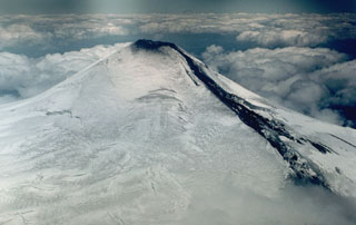 A lava flow descends the NE flank of Villarrica volcano in 1984. A small lava lake at the NNE side of the summit crater fed lava flows through a notch in the crater rim left by the 1971 eruption. The lava initially flowed down the summit icefield and then burrowed under the glacier. The flow emerged onto the surface on November 13, producing a 3-km-long avalanche of lava blocks, ice, and snow.
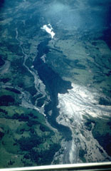 A dark lava flow descends the Chaillupén river on the SW flank of Villarrica volcano towards Lake Calafquén during an eruption in 1971. The lava flow overrides light-colored mudflow deposits produced earlier during the eruption, which began on October 29. On November 29 lava effusion and pyroclastic cone formation began. Three basaltic lava flows were emitted on the SW flank during December 3-20. The eruption culminated on December 29, when lava flows melted ice, producing lahars that swept the volcano's flanks and caused 15 fatalites. The eruption lasted until January 10.
 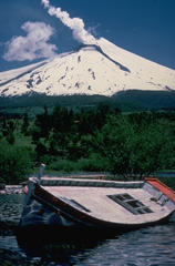 Villarrica, one of Chile's most active volcanoes during historical time, rises above Lake Villarrica. This December 1984 view from the NE shows steam rising from the summit crater and a lava flow descending the glacier-covered flanks of the volcano. This dominantly basaltic volcano has produced plinian eruptions and pyroclastic flows during the Holocene, but historical eruptions have consisted largely of mild-to-moderate explosive activity with occasional lava effusion. Lahars from the glacier-covered volcano have damaged towns on its flanks.
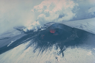 Lava fountaining from a lava lake at the NNE side of Villarrica's summit crater feeds steaming lava flows down the north and NE flanks in December 1984. The 1984-85 eruption began in August. Following intensified activity in October, the NE-flank lava flow melted a channel 50-m wide and 30-40 m deep and produced a 5-km-long avalanche. Lava melted through the ice and flowed beneath the glacier before emerging onto the surface again on November 13, generating a 3-km-long avalanche and leaving a 150-m-long ice bridge.
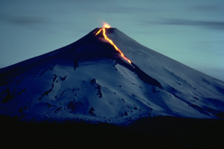 A night-time view of Chile's Villarrica volcano in December 1984 shows an incandescent lava flow descending the north and NE flanks and strombolian eruptions from the summit crater. The 1984-85 eruption began with small explosions and tephra emission on August 11. Renewed explosions, accompanied by lava flows, began on October 30, and lasted until February 26. Beginning in April and continuing until November 18, lava fountains and weak explosions producing minor ash were observed from Pucón, a town at the north foot of the volcano.
  A lahar from Villarrica volcano in the Chilean lake district sweeps down the Correntoso river into Lake Villarrica in December 1984. The lahar flattened a small wooden bridge and affected houses on the banks of the river. The mudflow originated when the rate of effusion of a lava flow moving down the glacier-covered flanks of the volcano increased during the afternoon of December 6. By the following day stream flow had returned to normal.
 Snow-covered Villarrica, one of Chile's most active volcanoes, rises above the resort town of Pucón below its northern flank. A faint steam plume drifts from an active lava lake in the summit crater. The steep summit cone was constructed within a mostly buried, 2-km-wide caldera whose dissected outer flanks rise above the tree line. Villarrica is the westernmost of three large stratovolcanoes that trend perpendicular to the Andean chain. Historical eruptions have been documented since 1558 CE.
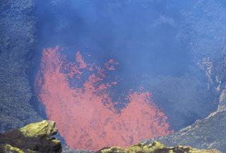 Incandescent spatter and bombs ejected from a lava lake at the bottom of a steep-sided, ~40-m-wide inner crater are seen from the SW rim of Villarrica's outer crater on November 19, 2004. Incandescence was seen above the summit crater the nights of August 5-6 and October 27-28, 2004 and frequently during November and December. Strombolian explosions ejected material to 100 m the night of December 12-13. Ground observations of summit lava lake activity and minor strombolian explosions were continued into 2006.
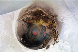 A near-vertical aerial view into the ~250-m-wide summit crater of Villarrica volcano on November 19, 2004 shows an incandescent lava lake in the steep-walled inner crater. The chain of dots left (north) of the crater are climbers near the crater rim. Night-time glow was periodically visible from the town of Pucón on the north flank of volcano beginning in August 2004 and intensified in November and December. Small strombolian explosions in December ejected spatter and bombs onto the crater rim.
 The following 6 samples associated with this volcano can be found in the Smithsonian's NMNH Department of Mineral Sciences collections, and may be availble for research (contact the Rock and Ore Collections Manager). Catalog number links will open a window with more information.
| Catalog Number | Sample Description | Lava Source | Collection Date |
|---|---|---|---|
| NMNH 112671 | Olivine Basalt | -- | -- |
| NMNH 112672 | Olivine Basalt | -- | -- |
| NMNH 117275-1 | Basaltic Andesite | -- | -- |
| NMNH 117275-2 | Scoria | -- | -- |
| NMNH 117275-3 | Lava | -- | -- |
| NMNH 117275-4 | Basalt | -- | -- |
| Copernicus Browser | The Copernicus Browser replaced the Sentinel Hub Playground browser in 2023, to provide access to Earth observation archives from the Copernicus Data Space Ecosystem, the main distribution platform for data from the EU Copernicus missions. |
| MIROVA | Middle InfraRed Observation of Volcanic Activity (MIROVA) is a near real time volcanic hot-spot detection system based on the analysis of MODIS (Moderate Resolution Imaging Spectroradiometer) data. In particular, MIROVA uses the Middle InfraRed Radiation (MIR), measured over target volcanoes, in order to detect, locate and measure the heat radiation sourced from volcanic activity. |
| MODVOLC Thermal Alerts | Using infrared satellite Moderate Resolution Imaging Spectroradiometer (MODIS) data, scientists at the Hawai'i Institute of Geophysics and Planetology, University of Hawai'i, developed an automated system called MODVOLC to map thermal hot-spots in near real time. For each MODIS image, the algorithm automatically scans each 1 km pixel within it to check for high-temperature hot-spots. When one is found the date, time, location, and intensity are recorded. MODIS looks at every square km of the Earth every 48 hours, once during the day and once during the night, and the presence of two MODIS sensors in space allows at least four hot-spot observations every two days. Each day updated global maps are compiled to display the locations of all hot spots detected in the previous 24 hours. There is a drop-down list with volcano names which allow users to 'zoom-in' and examine the distribution of hot-spots at a variety of spatial scales. |
|
WOVOdat
Single Volcano View Temporal Evolution of Unrest Side by Side Volcanoes |
WOVOdat is a database of volcanic unrest; instrumentally and visually recorded changes in seismicity, ground deformation, gas emission, and other parameters from their normal baselines. It is sponsored by the World Organization of Volcano Observatories (WOVO) and presently hosted at the Earth Observatory of Singapore.
GVMID Data on Volcano Monitoring Infrastructure The Global Volcano Monitoring Infrastructure Database GVMID, is aimed at documenting and improving capabilities of volcano monitoring from the ground and space. GVMID should provide a snapshot and baseline view of the techniques and instrumentation that are in place at various volcanoes, which can be use by volcano observatories as reference to setup new monitoring system or improving networks at a specific volcano. These data will allow identification of what monitoring gaps exist, which can be then targeted by remote sensing infrastructure and future instrument deployments. |
| Volcanic Hazard Maps | The IAVCEI Commission on Volcanic Hazards and Risk has a Volcanic Hazard Maps database designed to serve as a resource for hazard mappers (or other interested parties) to explore how common issues in hazard map development have been addressed at different volcanoes, in different countries, for different hazards, and for different intended audiences. In addition to the comprehensive, searchable Volcanic Hazard Maps Database, this website contains information about diversity of volcanic hazard maps, illustrated using examples from the database. This site is for educational purposes related to volcanic hazard maps. Hazard maps found on this website should not be used for emergency purposes. For the most recent, official hazard map for a particular volcano, please seek out the proper institutional authorities on the matter. |
| IRIS seismic stations/networks | Incorporated Research Institutions for Seismology (IRIS) Data Services map showing the location of seismic stations from all available networks (permanent or temporary) within a radius of 0.18° (about 20 km at mid-latitudes) from the given location of Villarrica. Users can customize a variety of filters and options in the left panel. Note that if there are no stations are known the map will default to show the entire world with a "No data matched request" error notice. |
| UNAVCO GPS/GNSS stations | Geodetic Data Services map from UNAVCO showing the location of GPS/GNSS stations from all available networks (permanent or temporary) within a radius of 20 km from the given location of Villarrica. Users can customize the data search based on station or network names, location, and time window. Requires Adobe Flash Player. |
| DECADE Data | The DECADE portal, still in the developmental stage, serves as an example of the proposed interoperability between The Smithsonian Institution's Global Volcanism Program, the Mapping Gas Emissions (MaGa) Database, and the EarthChem Geochemical Portal. The Deep Earth Carbon Degassing (DECADE) initiative seeks to use new and established technologies to determine accurate global fluxes of volcanic CO2 to the atmosphere, but installing CO2 monitoring networks on 20 of the world's 150 most actively degassing volcanoes. The group uses related laboratory-based studies (direct gas sampling and analysis, melt inclusions) to provide new data for direct degassing of deep earth carbon to the atmosphere. |
| Large Eruptions of Villarrica | Information about large Quaternary eruptions (VEI >= 4) is cataloged in the Large Magnitude Explosive Volcanic Eruptions (LaMEVE) database of the Volcano Global Risk Identification and Analysis Project (VOGRIPA). |
| EarthChem | EarthChem develops and maintains databases, software, and services that support the preservation, discovery, access and analysis of geochemical data, and facilitate their integration with the broad array of other available earth science parameters. EarthChem is operated by a joint team of disciplinary scientists, data scientists, data managers and information technology developers who are part of the NSF-funded data facility Integrated Earth Data Applications (IEDA). IEDA is a collaborative effort of EarthChem and the Marine Geoscience Data System (MGDS). |

