Antarctica Volcanoes

Antarctica has 19 Holocene volcanoes. Note that as a scientific organization we provide these listings for informational purposes only, with no international legal or policy implications. Volcanoes will be included on this list if they are within the boundaries of a country, on a shared boundary or area, in a remote territory, or within a maritime Exclusive Economic Zone. Bolded volcanoes have erupted within the past 20 years. Suggestions and data updates are always welcome ().
| Volcano Name | Last Eruption | Volcanic Region | Primary Landform |
|---|---|---|---|
| Andrus | Unknown - Evidence Uncertain | Western Antarctica Volcanic Province | Shield |
| Berlin | 8350 BCE | Western Antarctica Volcanic Province | Shield |
| Bridgeman Island | Unknown - Evidence Uncertain | South Shetlands Volcanic Arc | Composite |
| Buckle Island | 1899 CE | Balleny Hotspot Volcano Group | Composite |
| Deception Island | 1970 CE | South Shetlands Volcanic Arc | Caldera |
| Erebus | 2025 CE | McMurdo Volcanic Province | Composite |
| Hudson Mountains | 207 BCE | Western Antarctica Volcanic Province | Composite |
| Melbourne | 1892 CE | McMurdo Volcanic Province | Composite |
| Melville | Unknown - Evidence Uncertain | South Shetlands Volcanic Arc | Composite |
| Morning | Unknown - Evidence Uncertain | McMurdo Volcanic Province | Shield |
| Mount Haddington Volcanic Field | Unknown - Evidence Credible | Antarctic Peninsula Volcanic Province | Shield |
| Paulet | Unknown - Evidence Credible | Antarctic Peninsula Volcanic Province | Minor (Basaltic) |
| Penguin Island | 1905 CE | South Shetlands Volcanic Arc | Composite |
| The Pleiades | 1050 BCE | McMurdo Volcanic Province | Composite |
| Royal Society Range | Unknown - Evidence Uncertain | McMurdo Volcanic Province | Cluster |
| Sturge Island | Unknown - Evidence Uncertain | Balleny Hotspot Volcano Group | Composite |
| Takahe | 5550 BCE | Western Antarctica Volcanic Province | Shield |
| Unnamed | Unknown - Evidence Uncertain | McMurdo Volcanic Province | Caldera |
| Young Island | Unknown - Evidence Uncertain | Balleny Hotspot Volcano Group | Composite |
Chronological listing of known Holocene eruptions (confirmed or uncertain) from volcanoes in Antarctica. Bolded eruptions indicate continuing activity.
| Volcano Name | Start Date | Stop Date | Certainty | VEI | Evidence |
|---|---|---|---|---|---|
| Deception Island | [1987 Jul 23] | [Unknown] | Uncertain | ||
| Hudson Mountains | [1985 Jul 2 ± 182 days] | [Unknown] | Uncertain | ||
| Seal Nunataks Volcanic Field | [1980 Jun 15 ± 545 days] | [Unknown] | Uncertain | ||
| Erebus | 1972 Dec 16 (on or before) ± 15 days | 2025 Dec 29 (continuing) | Confirmed | 2 | Observations: Reported |
| Deception Island | [1972 Sep 29] | [1972 Sep 29] | Uncertain | ||
| Erebus | 1972 Jan 3 (?) | Unknown | Confirmed | 1 | Observations: Reported |
| Deception Island | 1970 Aug 12 | Unknown | Confirmed | 3 | Observations: Reported |
| Deception Island | 1969 Feb 21 | 1969 Mar 16 ± 15 days | Confirmed | 3 | Observations: Reported |
| Deception Island | 1967 Dec 4 | 1967 Dec 7 | Confirmed | 3 | Observations: Reported |
| Erebus | 1963 Nov 16 (on or before) ± 15 days | Unknown | Confirmed | 0 | Observations: Reported |
| Erebus | [1957 Jul 2 ± 182 days] | [1958 Jul 2 ± 182 days] | Uncertain | ||
| Erebus | 1955 Jul 2 ± 182 days | Unknown | Confirmed | 2 | Observations: Reported |
| Erebus | 1947 Feb | Unknown | Confirmed | 2 | Observations: Reported |
| Erebus | 1915 Aug | Unknown | Confirmed | 2 | Observations: Reported |
| Erebus | 1915 Mar 22 | Unknown | Confirmed | 2 | Observations: Reported |
| Erebus | 1912 Dec 12 | Unknown | Confirmed | 2 | Observations: Reported |
| Deception Island | 1912 ± 5 years | Unknown | Confirmed | 3 | Observations: Reported |
| Erebus | 1911 Oct | Unknown | Confirmed | 2 | Observations: Reported |
| Erebus | 1911 Apr | 1911 Jun | Confirmed | 2 | Observations: Reported |
| Erebus | 1908 Mar | 1908 Nov | Confirmed | 2 | Observations: Reported |
| Penguin Island | 1905 (?) | Unknown | Confirmed | Chem/Bio: Lichenometry | |
| Erebus | 1903 Jan 1 ± 730 days | Unknown | Confirmed | 0 | Observations: Reported |
| Erebus | [1900 Feb] | [Unknown] | Uncertain | ||
| Buckle Island | 1899 Jan 12 | Unknown | Confirmed | 2 | Observations: Reported |
| Seal Nunataks Volcanic Field | [1893 Dec 11] | [Unknown] | Uncertain | ||
| Melbourne | 1892 ± 30 years | Unknown | Confirmed | Correlation: Tephrochronology | |
| Deception Island | 1871 ± 40 years | Unknown | Confirmed | Correlation: Tephrochronology | |
| Penguin Island | 1850 (?) | Unknown | Confirmed | Observations: Reported | |
| Paulet | [1850] | [Unknown] | Uncertain | ||
| Deception Island | 1842 Feb | Unknown | Confirmed | 2 | Observations: Reported |
| Erebus | 1841 Jan 28 (?) | 1841 Feb | Confirmed | 1 | Observations: Reported |
| Buckle Island | 1839 Feb 9 | Unknown | Confirmed | 2 | Observations: Reported |
| Deception Island | [1839 (in or before)] | [Unknown] | Uncertain | ||
| Deception Island | 1827 ± 2 years | Unknown | Confirmed | Observations: Reported | |
| Deception Island | 1800 (in or before) | Unknown | Confirmed | Observations: Reported | |
| Penguin Island | 1683 (?) | Unknown | Confirmed | Chem/Bio: Lichenometry | |
| Deception Island | 1641 ± 3 years | Unknown | Confirmed | Sidereal: Ice Core | |
| Deception Island | 1500 (?) | Unknown | Confirmed | Isotopic: 14C (uncalibrated) | |
| Deception Island | 1200 (?) | Unknown | Confirmed | Isotopic: 14C (uncalibrated) | |
| Erebus | 0950 ± 4000 years | Unknown | Confirmed | 0 | Isotopic: Ar/Ar |
| Deception Island | 0900 (?) | Unknown | Confirmed | Isotopic: 14C (uncalibrated) | |
| Deception Island | 0600 (?) | Unknown | Confirmed | Isotopic: 14C (uncalibrated) | |
| Deception Island | 0100 (?) | Unknown | Confirmed | Isotopic: 14C (uncalibrated) | |
| Deception Island | 0100 BCE (?) | Unknown | Confirmed | Isotopic: 14C (uncalibrated) | |
| Hudson Mountains | 0207 BCE ± 240 years | Unknown | Confirmed | 4 | Sidereal: Ice Core |
| Deception Island | 0250 BCE (?) | Unknown | Confirmed | Isotopic: 14C (uncalibrated) | |
| Deception Island | 0550 BCE (?) | Unknown | Confirmed | Isotopic: 14C (uncalibrated) | |
| Deception Island | 0700 BCE (?) | Unknown | Confirmed | Isotopic: 14C (uncalibrated) | |
| Deception Island | 0750 BCE (?) | Unknown | Confirmed | Isotopic: 14C (uncalibrated) | |
| Deception Island | 0800 BCE (?) | Unknown | Confirmed | Isotopic: 14C (uncalibrated) | |
| The Pleiades | 1050 BCE ± 14000 years | Unknown | Confirmed | Isotopic: K/Ar | |
| Deception Island | 1550 BCE (?) | Unknown | Confirmed | Isotopic: 14C (uncalibrated) | |
| Erebus | 2050 BCE ± 3000 years | Unknown | Confirmed | 0 | Isotopic: Ar/Ar |
| Deception Island | 2750 BCE (?) | Unknown | Confirmed | Isotopic: 14C (uncalibrated) | |
| Erebus | 2950 BCE ± 300 years | Unknown | Confirmed | 0 | Isotopic: Cosmic Ray Exposure |
| Deception Island | 3250 BCE (?) | Unknown | Confirmed | Isotopic: 14C (uncalibrated) | |
| Erebus | 4050 BCE ± 500 years | Unknown | Confirmed | 0 | Isotopic: Cosmic Ray Exposure |
| Erebus | 4550 BCE ± 500 years | Unknown | Confirmed | 0 | Isotopic: Cosmic Ray Exposure |
| Takahe | 5550 BCE (?) | Unknown | Confirmed | Sidereal: Ice Core | |
| Takahe | 6250 BCE ± 5400 years | Unknown | Confirmed | Isotopic: Ar/Ar | |
| Deception Island | 6750 BCE (?) | Unknown | Confirmed | Isotopic: 14C (uncalibrated) | |
| Erebus | 7050 BCE ± 2000 years | Unknown | Confirmed | 0 | Isotopic: Ar/Ar |
| Takahe | 7050 BCE (?) | Unknown | Confirmed | Sidereal: Ice Core | |
| Erebus | 8050 BCE ± 5000 years | Unknown | Confirmed | 0 | Isotopic: Ar/Ar |
| Berlin | 8350 BCE ± 5300 years | Unknown | Confirmed | 0 | Isotopic: Ar/Ar |
Antarctica has 29 Pleistocene volcanoes. Note that as a scientific organization we provide these listings for informational purposes only, with no international legal or policy implications. Volcanoes will be included on this list if they are within the boundaries of a country, on a shared boundary or area, in a remote territory, or within a maritime Exclusive Economic Zone. Suggestions and data updates are always welcome ().
| Volcano Name | Volcanic Region | Primary Landform |
|---|---|---|
| Adare Peninsula | McMurdo Volcanic Province | Shield |
| Argo Point | Antarctic Peninsula Volcanic Province | Minor |
| Beaufort Island | McMurdo Volcanic Province | Composite |
| Beethoven Peninsula | Western Antarctica Volcanic Province | Cluster |
| Black Island | McMurdo Volcanic Province | Minor |
| Brabant Island | Antarctic Peninsula Volcanic Province | Cluster |
| Bursey | Western Antarctica Volcanic Province | Shield |
| Crary Group | Western Antarctica Volcanic Province | Cluster |
| Discovery | McMurdo Volcanic Province | Composite |
| Franklin Island | McMurdo Volcanic Province | Shield |
| Gaussberg | Eastern Antarctica Volcanic Province | Minor |
| Hut Point Peninsula | McMurdo Volcanic Province | Cluster |
| Livingston-Greenwich Islands | South Shetlands Volcanic Arc | Minor |
| Mason Spur | McMurdo Volcanic Province | Cluster |
| Murphy | Western Antarctica Volcanic Province | Shield |
| Obiglio | Western Antarctica Volcanic Province | Minor |
| Peter I Island | Western Antarctica Volcanic Province | Shield |
| Mount Rittmann | McMurdo Volcanic Province | Shield |
| Seal Nunataks Volcanic Field | Antarctic Peninsula Volcanic Province | Cluster |
| Shepard Island | Western Antarctica Volcanic Province | Minor |
| Siple | Western Antarctica Volcanic Province | Shield |
| Tabarin Peninsula | Antarctic Peninsula Volcanic Province | Shield |
| Taylor Valley | McMurdo Volcanic Province | Minor |
| Terror | McMurdo Volcanic Province | Shield |
| Toney Mountain | Western Antarctica Volcanic Province | Shield |
| Transantarctic Mountain Foothills | McMurdo Volcanic Province | Minor |
| Unnamed | McMurdo Volcanic Province | Cluster |
| Waesche | Western Antarctica Volcanic Province | Shield |
| White Island | McMurdo Volcanic Province | Shield |
There are 42 photos available for volcanoes in Antarctica.
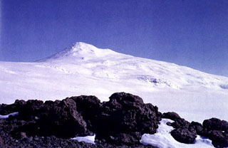 Mount Berlin is seen here from Mount Moulton to the east and is located in the Flood Range of Marie Byrd Land, near the eastern coast of the Ross Sea. Major features include Berlin Crater and Merrem Peak, with active fumaroles around the western and northern Berlin Crater rims.
Photo by Oscar González-Ferrán (University of Chile).
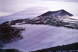
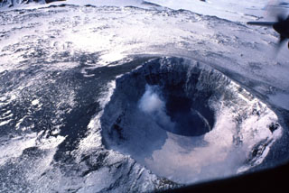
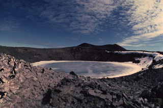
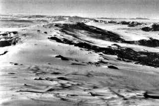 Mount Morning is seen in this aerial view from the NE. The summit contains an ice-filled 4.1 x 4.9 km caldera. Numerous flank lava domes and scoria cones formed along fissures on Hurricane Ridge across the NE flank to the middle right, and on the Riviera Ridge beyond on the N flank.
Photo by U.S. Navy.
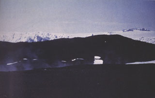
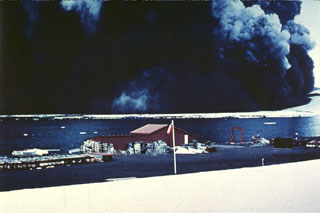 A wide, dark, ash-laden eruption plume towers above Pendulum Bay on 4 December 1967, originating from vents located about 2 km NW of the Chilean research station seen in the foreground. Heavy ashfall from the eruption severely damaged the Chilean base. The destruction of the base was completed by a subsequent eruption in 1969. Members of the research party walked about 6 km S to safety at the British research station on the first day of the eruption and were then evacuated by helicopter.
Photo by Bernardo Blass, 1967 (published in González-Ferrán, 1995).
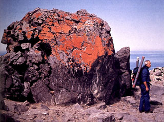 This large block, about 4 m3 in size, was expelled by phreatomagmatic explosions accompanying the formation of Petrel Crater maar. The eruption, which formed a low relief 300-m-wide crater in about 1905 CE, marked the most recent recorded activity on Penguin Island. The growth rate of the reddish-orange lichens mantling the upper part of the ejected block was used to estimate the date of the eruption.
Photo by Oscar González-Ferrán (University of Chile).
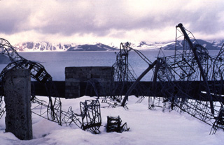 These twisted girders are remnants of the Chilean Antarctic reseach station on the NE side of Deception Island. The 1969 eruption from vents along the east side of the caldera bay damaged or destroyed the Chilean and British scientific bases, as well as the island's whaling station. The 1969 eruption took place from a roughly N-S-trending line of vents that cut a glacier west of Mount Pond.
Copyrighted photo by Katia and Maurice Krafft, 1984.
 Satellitic cinder cones on the flank of Mount Waesche are composed of black, vesicular lava flows and ejected pyroclastic material of basaltic composition. Numerous pyroclastic cones, some erupted along radial fissures, cover a broad area on the SW flank of Mount Waesche.
Photo by Oscar González-Ferrán (University of Chile).
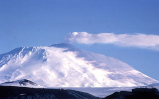
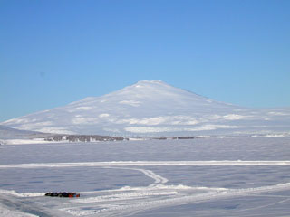
 Mount Erebus is seen here from the west and is Earth's southernmost active volcano. A largely infilled caldera forms a plateau at the summit where the active cone is located. Fang Ridge is the dark area on the NE flank (left).
Photo by Bill Rose, 1983 (Michigan Technological University).
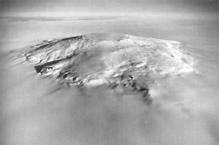
 Mount Siple forms the high point of Siple Island in Marie Byrd Land off the coast of Antarctica. This aerial view looks east, with dark-colored open water in the foreground and the Getz Ice Shelf between the island and Antarctica. Most volcanic features are buried in snow and ice, but the Lovill Bluff tuff cone outcrops at sea level (bottom right). Trachytic rocks at the summit have been Ar-Ar dated to about 227,000 and 169,000 years old.
U. S. Navy photo TMA 1627 F33 088, 1985.
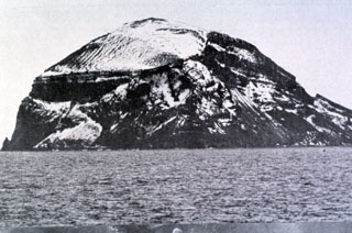 The steep Bridgeman Island, seen here from the SE, is a 600 x 900 m remnant of a much larger volcanic edifice that is mostly submerged. The base displays bedded pyroclastic rocks, and an erosional surface cut into these rocks is filled by horizontal lava flows (left center). The extensively eroded island does not display youthful volcanic features.
Photo by Oscar González-Ferrán (University of Chile).
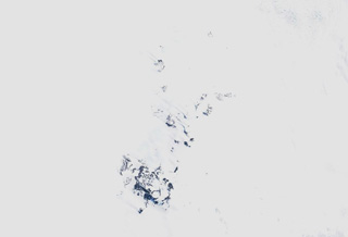
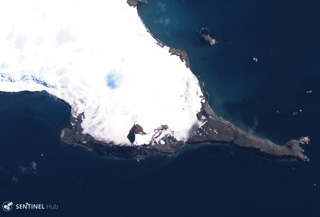
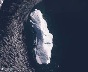 The roughly 32-km-long Sturge Island is shown in this 3 March 2019 Sentinel-2 satellite image (N is at the top). It is the southernmost of the three main Balleny islands, with Buckle and Young to the north.
Satellite image courtesy of Copernicus Sentinel Data, 2020.
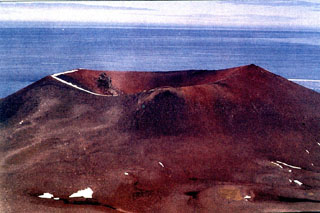
 Paulet Island, seen here from the northwest, is a 1.8 x 2.2 km island located east of the tip of Graham Land Peninsula. A basal sequence of horizontal lava flows exposed in steep cliffs is capped by a well-preserved cinder cone complex (top center) with a small distinct summit crater. The darker brownish areas near and above the shoreline at the center of the photo are Adelie penguin colonies.
Photo by Jeff Post, 2007 (Smithsonian Institution).
 Toney Mountain in east-central Marie Byrd Land is an elongate ~55 x 15 km E-W volcanic massif with a ~2.8 km diameter central summit caldera and several satellite cones. It is almost entirely mantled by glaciers. The age of the most recent eruption of the volcano is unknown, but the youngest dated deposit is about 290,000 years ago.
 Photo by Oscar González-Ferrán (University of Chile).
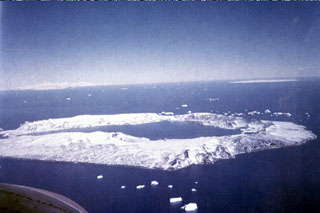 Deception Island in Antarctica contains a 7-km-wide caldera flooded by the sea. A narrow passageway named Neptune’s Bellows cuts through the caldera wall to the left. Numerous vents located along the caldera ring fractures around the low, 14-km-wide island have been active during historical time. Maars produced by magma-water interaction occur across the shores of the 190-m-deep Port Foster.
Photo by Juan Bastias (published in González-Ferrán, 1995).
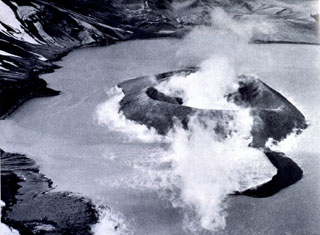
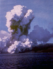 A plume of ash and steam rises above Telefon Bay on 4 December 1967. The eruption occurred from submarine vents in Telefon Bay, in the northwest part of the caldera bay, forming a new island named Yelcho. A second eruption center opened on land to the east. During the peak of activity the plume rose over 10 km above the vent, and pyroclastic material covered most of Deception Island. Ashfall occurred throughout the South Shetland Islands.
Photo by British Antarctic Survey, 1967 (published in González-Ferrán, 1995).
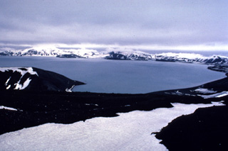 The western wall of Deception Island caldera is visible across Port Foster caldera bay from the Chilean Antarctic research station at Pendulum Cove. Eruptions took place at Telefon Bay, on the opposite shore of the flooded caldera during 1967 and 1970. An eruption in 1969 completely destroyed the Chilean base.
 Copyrighted photo by Katia and Maurice Krafft, 1984
 The roughly 30-km-long Young Island is shown in this 24 January 2020 Sentinel-2 satellite image (N is at the top). It is the northernmost of the three main Balleny islands, with Buckle and Sturge to the south.
Satellite image courtesy of Copernicus Sentinel Data, 2020.
 The ice-filled crater of Petrel maar is here seen from the southwest; this approximately 300-m-wide crater formed in a phreatomagmatic eruption about 1905 CE. Petrel maar and Deacon Peak are the two main vents identified on Penguin Island, and represent the youngest activity.
 Photo by Oscar González-Ferrán (University of Chile).
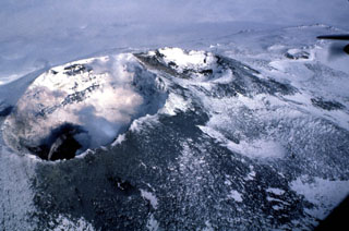
 Steam rises above a new island formed during an eruption in Telefon Bay at Deception Island during 4-7 December 1967. The eruption occurred from four vents along a NE-SW line cutting across the bay, building an approximately 1-km-long, 62-m-high island which was named Yelcho, after a research vessel that was there at the time. An eruption in 1970 occurred at approximately the same location, destroying much of Yelcho, and incorporating the remnants onto a new stretch of land attached to the inner caldera wall.
 Photo by the Chilean Navy, 1967 (published in González-Ferrán, 1995).
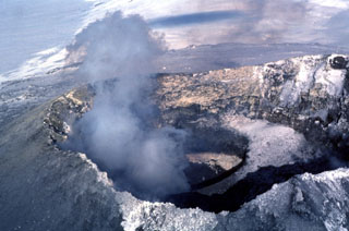
 Two summit craters at Erebus are seen in this view, with the 500 x 600 m Main Crater (left) containing an active lava lake (lower left) within the Inner Crater. A smaller inactive crater (center), referred to as Side Crater, is located immediately SW of Main Crater. The smaller West Crater is to the upper right.
Photo by Bill Rose, 1983 (Michigan Technological University).
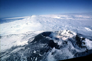
 Mount Erebus is viewed here from the SE, with the water of the Ross Sea behind it and the mountains of Victoria Land in the distance. Fang Ridge is above the snow-free slope (right) on the NE flank. The plateau right of the summit is the lava flow-filled floor of the summit caldera, inside which the active summit cone was constructed. Hut Point Peninsula is the site of the McMurdo Station and is to the left of the Ross Sea.
Photo by Bill Rose, 1983 (Michigan Technological University).
 Murdoch Nunatak is one of a group of 16 nunataks (exposed ridges emerging from ice) in the Seal Nunataks Volcanic Field, on the east coast of northern Antarctic Peninsula. The collapse of the Larsen Ice shelf means that some nunataks can now be described as islands. Murdoch is the largest nunatak in the group, with a flat top and steep sides.
Photo by Oscar González-Ferrán (University of Chile).
 The Pleiades volcanic group is located in Melbourne Volcanic Province of Antarctica and is shown in the center of this 8 December 2019 Sentinel-2 satellite image (N is at the top; this image is approximately 20 km across). Mt. Pleiones is in the south of the southernmost exposed area, and Mt. Atlas forms the northeastern exposed area. Features to the north include the Alcyone and Taygete cones.
Satellite image courtesy of Copernicus Sentinel Data, 2020.
 Deacon Peak scoria cone on Penguin Island contains a summit crater approximately 350 m wide and 75 m deep. The upper slopes of the cone are composed of reddish oxidized pyroclastic rocks. The formation of Deacon Peak was dated to about 1679 CE using lichenometry, which is based on the calibration of lichen growth rates.
Photo by Oscar González-Ferrán (University of Chile).
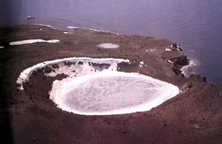
 The small 1.4 x 1.7 km Penguin Island, seen here from the SW, is located off the SE coast of King George Island in the South Shetland Islands. The most prominent feature is Deacon Peak (center), a largely basaltic scoria cone with a 350-m-wide summit crater. Petrel Crater, a 300-m-wide maar, is located behind Deacon Peak, out of view in this photo. Both Deacon Peak and Petrel Crater were formed within the past few hundred years.
Photo by Oscar González-Ferrán (University of Chile).
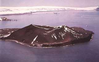
 The small 1.8 x 2.2 km Paulet island, seen here in an aerial view from the west, is composed of lava flows capped by the Volcán Paulet and Volcán Larsen scoria cones. The largest and youngest cone, Paulet, contains a small circular summit crater of less than 100 m diameter. A small lake fills a maar-like depression called Volcán Andersson (center left).
Photo published in González-Ferrán (1995).
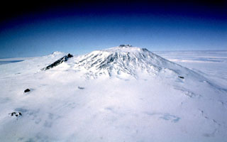
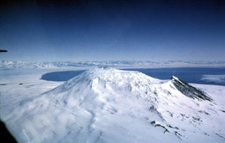
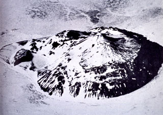
 This aerial view looks northeast across the trachytic shield volcano Mount Takahe, with an ice-filled 8-km-diameter caldera at the summit. The approximately 30-km-wide edifice rises about 2,000 m above the surrounding ice sheet. Eruption deposits indicate both subaqueous and subaerial eruptions, and include lavas and tephra. Möll Spur (right of center) is a prominent steep ridge of lava produced in two sequences at about 34 and 17 ka. The most recent eruption occurred around 5.6 ± 0.8 ka, producing widespread tephra distribution across West Antarctica.
U. S. Navy photo TMA 1718 F33 022.
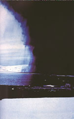 An eruption darkens the sky above Antarctica's Deception Island in December 1967. Falling ash can be seen trailing from the margins of the eruption cloud. Winds distributed the ash plume to the NE and deposited 30 cm of ash over a 2 km swath across Port Foster caldera bay onto the Chilean Antarctic research station, where this photo was taken.
Photo by Bernardo Blass, 1967 (published in González-Ferrán, 1995).
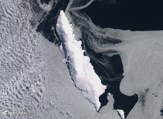
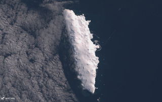 The 21-km-long Buckle Island near Antarctica is shown in this 2 March 2019 Sentinel-2 satellite image (N is at the top). It is one of three main Balleny islands of similar size with Young to the N and Sturge S and is 110 km NNE of Belousov Point.
Satellite image courtesy of Copernicus Sentinel Data, 2019.
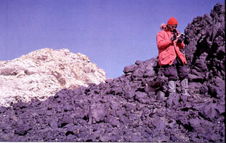 A geologist examines lava flows west of the 4.5-km-wide summit caldera of Mount Andrus. This volcano is the youngest of three N-S-trending volcanoes in the Ames Range of western Marie Byrd Land, Antarctica.
 Photo by Oscar González-Ferrán (University of Chile).
 Melville is located on the southern peninsula at the east end of King George Island, Antarctica, in the area shown in this 19 January 2020 Sentinel-2 satellite image (N is at the top; this image is approximately 9 km across).
Satellite image courtesy of Copernicus Sentinel Data, 2020.
 The summit of Antarctica's Mount Erebus is the world's southernmost active volcano. It contains an elliptical 500 x 600 m wide crater whose NE side contains a 250-m-wide, 100-m-deep inner crater. The flat, snow-covered floor of the Main Crater is about 100 m below its rim. A plume rises from the inner crater that has contained an active lava lake since 1972.
Photo by Bill Rose, 1983 (Michigan Technological University).
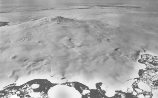
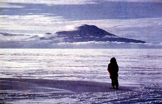
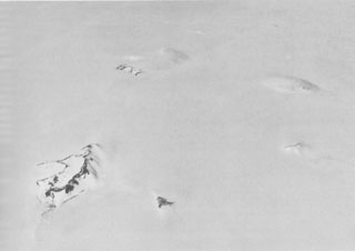 Hudson Mountains volcanic field comprises about 20 volcanic nunataks. These are peaks protruding from ice, and here represent the surface expression of multiple volcanic vents. At least four nunataks can be seen faintly in this image, looking across the southern Hudson Mountains from the west. The exposed ridge in the left foreground is Webber Nunatak. The uppermost, largely ice-covered nunatak seen here is Mount Manthe, one of the largest peaks in this volcanic field and dated to about 5 million years ago. A tephra layer from this field was erupted about 2,000 years ago.
U. S. Navy photo TMA 2035 F31 203.
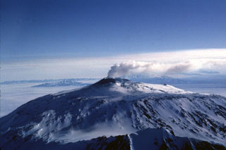
 A gas plume from the Erebus summit crater casts a shadow on its western flank. There is an active lava lake in this crater and a caldera forms the plateau to the left of the summit cone. The McMurdo Station research facility on Hut Peninsula is in the foreground.
Photo by Bill Rose, 1983 (Michigan Technological University).
 Petrel maar is a 300-m-wide crater on the eastern side of the roughly 1.5-km-wide Penguin Island. The maar was formed during an explosive eruption in the early 20th century and is surrounded by angular blocks of ejecta. The cinder cone behind Petrel maar to the SW is Deacon Peak, which marks the 180-m-high summit of the island.
 Copyrighted photo by Katia and Maurice Krafft, 1984.
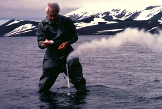 French volcanologist Jean-Louis Cheminée samples volcanic gases from a shallow submarine fumarole in the caldera of Deception Island. The temperature of the fumarole varied from 100 to 200 degrees Centigrade.
Copyrighted photo by Katia and Maurice Krafft, 1984.
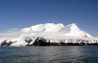 Peter I Island, located in the Bellingshausen Sea opposite Ellsworth Land, is seen here from the north showing the Lars Christiansen Peak. This volcanic island has a steep coastline and is more dissected on the northern side, with a broader more gentle slope to the south. The most recent dated activity occurred about 100,000 years ago.
Photo by Melvin Vye, 2006.
 Two of the three volcanoes forming Ross Island are seen in this aerial view from the west. The Erebus summit crater that contains an active lava lake is in the foreground, with glaciated Mount Terror in the distance. Numerous scoria cones and lava domes have formed across the flanks.
Photo by Bill Rose, 1983 (Michigan Technological University).
 A gas-and-steam plume rises above the Mount Erebus summit crater in 1983. Fang Ridge is in the foreground of this view from the NE. The summit plateau across the center of the photo is the rim of a caldera containing the active summit cone.
Photo by Bill Rose, 1983 (Michigan Technological University).
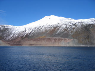
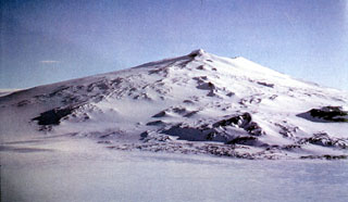
 Mount Melbourne towers above the ice shelf of the Ross Sea in Antarctica's Northern Victoria Land. The glaciated edifice contains a large number of scoria cones, lava domes, and viscous lava flows. Lava fields are exposed at the summit and upper flanks. Fumarolic activity has been observed and there are corresponding tephra layers within and on top of surrounding ice layers.
Photo by Arrigo Caserta, 2000 (Istituto Nazionale di Geofisica e Vulcanologia, Roma).
 A gas plume rises above the active lava lake at the summit of Erebus in December 1983, which was first observed on 24 December 1972. Lava lake activity and intermittent Strombolian eruptions have been observed during annual scientific expeditions since then. The lava is located at the bottom of an inner 100-m-deep crater, whose snow-covered rim forms a bench at the right (SW) side of the Main Crater in this 1983 photo.
Photo by Bill Rose, 1983 (Michigan Technological University).
 Mount Waesche is the southernmost of volcano of the Executive Committee Range in central Marie Byrd Land. The southwestern flanks seen here are largely ice-free. Scoria cones with a radial alignment are present, along with outcrops dominated by ‘a’a lavas. A caldera of approximately 2 km diameter is present at the summit.
Photo by Oscar González-Ferrán (University of Chile).
 Mount Erebus is seen here from the SW near the McMurdo research station on Ross Island and the world's southernmost active volcano. The summit has a 500 x 600 m wide, 110-m-deep crater that contains an active lava lake. The glaciated volcano was erupting when first sighted by Captain James Ross in 1841. Continuous lava lake activity has been documented since 1972, punctuated by occasional Strombolian explosions that eject bombs onto the crater rim.
Photo by Richard Waitt, 1972 (U.S. Geological Survey).
This is a compilation of Antarctica volcano information sources, such as official monitoring or other government agencies.
| Volcanic Ash Advisory Center |
|---|
| Buenos Aires Volcanic Ash Advisory Center (VAAC) |
| - Buenos Aires VAAC Archive |