Greece Volcanoes
Greece has 5 Holocene volcanoes. Note that as a scientific organization we provide these listings for informational purposes only, with no international legal or policy implications. Volcanoes will be included on this list if they are within the boundaries of a country, on a shared boundary or area, in a remote territory, or within a maritime Exclusive Economic Zone. Bolded volcanoes have erupted within the past 20 years. Suggestions and data updates are always welcome ().
| Volcano Name | Last Eruption | Volcanic Region | Primary Landform |
|---|---|---|---|
| Kolumbo | 1650 CE | Hellenic Volcanic Arc | Cluster |
| Methana | 258 BCE | Hellenic Volcanic Arc | Minor (Basaltic) |
| Milos | 140 CE | Hellenic Volcanic Arc | Composite |
| Nisyros | 1888 CE | Hellenic Volcanic Arc | Composite |
| Santorini | 1950 CE | Hellenic Volcanic Arc | Shield |
Chronological listing of known Holocene eruptions (confirmed or uncertain) from volcanoes in Greece. Bolded eruptions indicate continuing activity.
| Volcano Name | Start Date | Stop Date | Certainty | VEI | Evidence |
|---|---|---|---|---|---|
| Santorini | 1950 Jan 10 | 1950 Feb 2 | Confirmed | 2 | Observations: Reported |
| Santorini | 1939 Aug 20 | 1941 Jul 2 ± 1 days | Confirmed | 2 | Observations: Reported |
| Santorini | 1928 Jan 23 | 1928 Mar 17 | Confirmed | 2 | Observations: Reported |
| Santorini | 1925 Aug 11 | 1926 May | Confirmed | 2 | Observations: Reported |
| Methana | [1922 Aug] | [Unknown] | Uncertain | ||
| Nisyros | 1888 Sep 25 ± 4 days | Unknown | Confirmed | 2 | Observations: Reported |
| Nisyros | 1873 Jun | 1873 Sep 26 | Confirmed | 2 | Observations: Reported |
| Nisyros | 1871 | Unknown | Confirmed | 2 | Observations: Reported |
| Santorini | 1866 Jan 26 | 1870 Oct 15 | Confirmed | 2 | Observations: Reported |
| Santorini | 1707 May 23 | 1711 Sep 14 | Confirmed | 3 | Observations: Reported |
| Kolumbo | 1650 Sep 27 | 1650 Dec 6 | Confirmed | 4 | Observations: Reported |
| Santorini | 1570 | 1573 | Confirmed | 3 | Observations: Reported |
| Nisyros | 1422 | Unknown | Confirmed | 2 | Observations: Reported |
| Santorini | 0726 Jul 15 ± 45 days | Unknown | Confirmed | 4 | Observations: Reported |
| Milos | 0140 ± 300 years | Unknown | Confirmed | 1 | Isotopic: 14C (calibrated) |
| Santorini | 0046 Dec 31 | 0047 Feb 1 ± 30 days | Confirmed | 3 | Observations: Reported |
| Santorini | 0197 BCE | Unknown | Confirmed | 3 | Observations: Reported |
| Methana | 0258 BCE ± 18 years | Unknown | Confirmed | 3 | Observations: Reported |
| Santorini | 1610 BCE ± 14 years | Unknown | Confirmed | 7 | Isotopic: 14C (calibrated) |
Greece has 7 Pleistocene volcanoes. Note that as a scientific organization we provide these listings for informational purposes only, with no international legal or policy implications. Volcanoes will be included on this list if they are within the boundaries of a country, on a shared boundary or area, in a remote territory, or within a maritime Exclusive Economic Zone. Suggestions and data updates are always welcome ().
| Volcano Name | Volcanic Region | Primary Landform |
|---|---|---|
| Aegina | Hellenic Volcanic Arc | Cluster |
| Antiparos | Hellenic Volcanic Arc | Minor |
| Kos | Hellenic Volcanic Arc | Caldera |
| Poros | Hellenic Volcanic Arc | Cluster |
| Psathoura | Western Anatolian Volcanic Province | Minor |
| Volos-Atalanti | Western Anatolian Volcanic Province | Cluster |
| Yali | Hellenic Volcanic Arc | Composite |
There are 30 photos available for volcanoes in Greece.
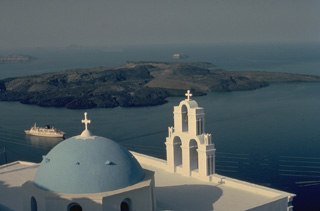
 An aerial view from the east overlooks the outer flanks of Santorini's 7.5 x 11 km caldera. The far caldera rim, part of which is flooded by the sea, appears at the upper left and right. The towns of Firá and Merovígli sit on the caldera rim and farms drape the outer flanks of the volcano, which are underlain by deposits from the cataclysmic Minoan-age eruption about 3,500 years ago. The post-caldera islands of Nea and Palaea Kameni (upper-center) were constructed in the middle of the caldera during eruptions dating back to 197 BCE.
Photo by Lee Siebert, 1994 (Smithsonian Institution)
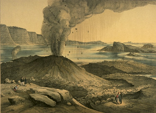 An eruption from 1866 to 1870 at Nea Kameni Island in the center of Santorini caldera began with quiet submarine effusion of lava that built a dome above sea level. During the course of the eruption, three volcanic centers were formed, which issued lava flows, sometimes accompanied by explosive activity, such as depicted in this sketch, viewed form the NE. Lava flows from this eruption underlie more than half of the island of Nea Kameni. The island of Palea Kameni, which formed in 46-47 CE, is visible at the right.
From the collection of Maurice and Katia Krafft.
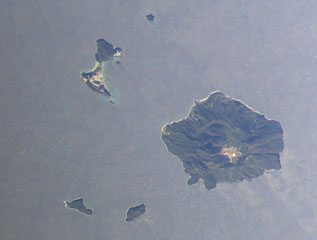 The island of Yali (upper left) and the island of Nisyros Island (lower right) are shown this NASA International Space Station image (with N to the upper left). Yali contains two distinct segments connected by a narrow isthmus formed of modern reef sediments and consists of rhyolitic obsidian domes at the NE end and pumice-fall deposits at the SW end. A caldera 3-4 km wide, much of the W side of which is filled by post-collapse lava domes, is visible on Nisyros Island.
NASA International Space Station image ISS006-E-30975, 2003 (http://eol.jsc.nasa.gov/).
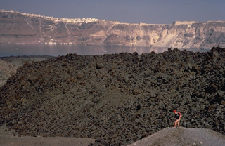 The small, blocky lava dome in the foreground is the product of an eruption of Santorini volcano during 1939-1941. This eruption, smaller than previous post-Minoan eruptions of Santorini, began with phreatic explosions, and concluded with the effusion of the dome and small lava flows. French volcanologist Maurice Krafft provides scale in the foreground, and the steep walls of Santorini's largely submerged caldera, capped by the whitewashed village of Firá, rise to the NE across the caldera bay.
Copyrighted photo by Katia and Maurice Krafft, 1970.
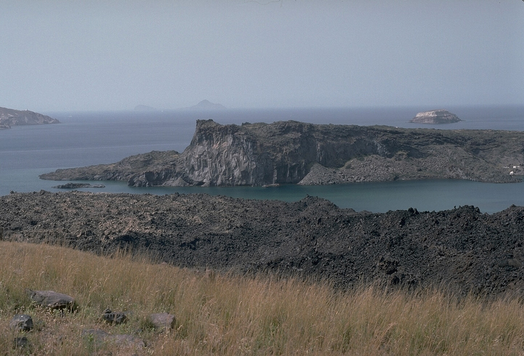
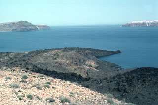
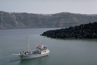
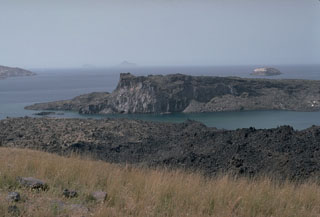 Palaea Kameni (Thia) Island (center) was formed by the extrusion of lava flows during a 46-47 CE eruption. This was the second documented eruption producing a new island in the caldera bay. The black lava flows in the foreground on Nea Kameni island were emplaced during an 1866-1870 eruption. The small island in the right distance to the SW, capped by light-colored rocks of the 3,600-year-old Minoan eruption, is part of the caldera wall that extends beneath the sea surface to the Akrotíri Peninsula on the extreme left.
Photo by Lee Siebert, 1994 (Smithsonian Institution).
 The mostly-submerged caldera of Santorini volcano is seen from space in this NASA satellite image. The 7.5 x 11 km caldera was formed during at least four major explosive eruptions, the last of which occurred about 1,650 BCE. The arcuate islands of Thira (right) and Therasia (left) form the outer flanks of the caldera. Nea Kameni Island is near the center of the caldera, which along with Palea Kameni Island to its left, is part of a post-caldera cone formed during historical eruptions dating back to 197 BCE.
NASA ASTER image, 2000 (http://eol.jsc.nasa.gov/).
 The dark-colored lava flow at the right center of the photo, and the crater in the foreground, were formed during an eruption from 1939 to 1941. The lava flows traveled to the E and W, reaching almost to the sea on the E side and extending into the caldera bay at several locations on the W side on Nea Kameni island. A chain of N-S-trending craters was formed during the eruption. The crater seen in this photo cut lava flows of an earlier 1866-1870 eruption.
 Photo by Lee Siebert, 1994 (Smithsonian Institution).
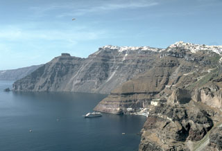
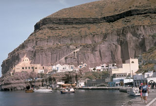
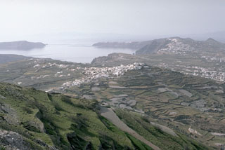 The outer flanks of the Santorini caldera, mantled by deposits of the 3,500-year-old Minoan eruption, provide a setting for croplands and island villages. This view looks NW from Mt. Profitis Ilias, a limestone peak forming the high point of the island of Thera, shows the northern half of the 7.5 x 11 km caldera. The northern rim drops below sea level, leaving a channel between the tip of Thera and the island of Therasia to the left.
Photo by Lee Siebert, 1994 (Smithsonian Institution).
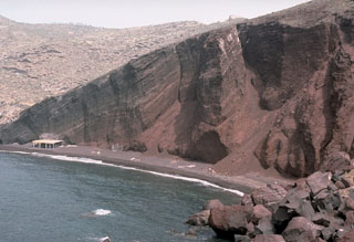
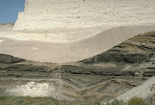 This outcrop shows light-colored deposits from the 3,500-year-old Minoan eruption of Santorini filling a valley that eroded into darker tephra layers of Pleistocene age. The lower beige-colored unit filling the valley is a pumice-fall deposit from early in the eruption. It is overlain by laminated pyroclastic surge deposits that were produced when water came into contact with the magma reservoir as the volcano collapsed into the sea. The upper lighter-colored layer truncating both these deposits is a pyroclastic flow deposit.
Photo by Lee Siebert, 1994 (Smithsonian Institution).
 The crater in the foreground was formed during an eruption from 1570-1573 CE. Initially submarine eruptions were followed by the formation of the new island of Mikri Kameni (Little Burnt Island) NE of Palaea Kameni Island. The 1570-73 eruption created a small island with a diameter of about 400 m and a height of 70 m, topped by a 20-m-deep crater. The western wall of Santorini's caldera appears in the background, capped by the houses of the village of Merovígli.
Photo by Lee Siebert, 1994 (Smithsonian Institution)
 Palaea Kameni Island (right-center) rises from Santorini's caldera bay SE of the foreground cliffs of Thirasia Island. The higher, flat-topped part of the island was formed during 46-47 CE, and the slopes in front of it date back to 726 CE. The highly explosive eruption of the summer of 726 produced great quantities of pumice and ash that were transported as far as the islands of Abydos and Lesbos, Asia Minor, and Macedonia. Extrusion of the Ayios Nikolaos lavas followed, which eventually joined the NE tip of Thia (Palaea Kameni) Island.
Photo by Lee Siebert, 1994 (Smithsonian Institution)
 The black lava flows that descend into Santorini's caldera bay are the Dafni lavas, erupted during 1925-26. During this eruption, which began in August 1925 and lasted until January 1926, Nea Kameni became a single island as the Dafni lavas united Mikra Kameni, Nea Kameni, and the Georgios domes. Eruptions resumed in May 1926, producing small pyroclastic flows. The steep-sided eastern caldera wall rises in the distance, capped by the town of Fira and the smooth-textured pyroclastic-flow deposits of the Minoan eruption.
Photo by Lee Siebert, 1994 (Smithsonian Institution)
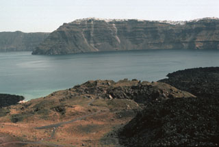
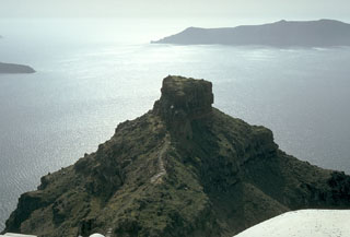 During Medieval times the Skaros promontory, formed of lavas of the Skaros shield volcano, was a densely populated catholic fortress bristling with buildings. The fortress was constructed because it offered protection from pirates, but following a series of strong earthquakes accompanying the 1707-1711 and other eruptions, it was progressively abandoned, and few building remnants remain. Therasia Island lies across the caldera at the upper right, and the tip of Nea Kameni Island in the center of the caldera appears at the left.
Photo by Lee Siebert, 1994 (Smithsonian Institution).
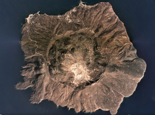
 The Mount Hagi Ilias lava dome occupies the western side of a 3-4 km wide caldera at the summit of Nisyros volcano, the easternmost of the Aegean arc. Five large post-caldera lava domes completely fill the western part of the caldera. Historical phreatic eruptions occurred within the caldera between 1422 and 1888.
Photo by Ichio Moriya (Kanazawa University).
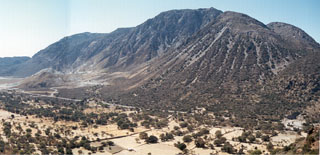
 Malja Khoriou lava dome, seen here from the SE, lies on the eastern side of the Methana Peninsula and is one of several lava domes forming the Methana volcanic complex. The peninsula extends into the Sarronian Gulf on the NE side of the Peloponnesus Peninsula. Kameno Vouno is the youngest dome, located on the NW side of the Peninsula where it formed in the 3rd century BCE and produced a lava flow that traveled 500 m beyond the coastline.
Photo by Ichio Moriya (Kanazawa University).
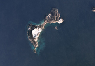 Yali is the uppermost part of a submerged caldera and is part of the Nisyros volcanic field. The SW part of the 4-5 km island is composed of the Lower and Upper Pumice deposits, and the NE area consists of lave domes, seen in this December 2019 Planet Labs satellite image monthly mosaic (N is at the top). The pumice quarry in the SW exposes pumice deposits in 60-100 m thick sections.
Satellite image courtesy of Planet Labs Inc., 2019 (https://www.planet.com/).
 Light-colored ignimbrite deposits, eroded into mesas bounded by steep-walled valleys, cap the central part of the island of Kos. The island is dominantly non-volcanic but contains Miocene to Pleistocene volcanic centers. The Kamari caldera is of mid-Pleistocene age and contains the 1.0-0.55 million-year-old, post-caldera Zini lava dome. The widespread Kos Plateau Tuff (145,000 years old) originated from a submarine source between Kos and Nisyros islands. Several geothermal areas are found on Kos.
Photo by Ichio Moriya (Kanazawa University).
 The western side of Mílos Island contains a cluster of lava domes. Mílos and adjacent small islands have grown from submarine and subaerial volcanism that initially was dominantly andesitic and basaltic, but ended with primarily rhyolitic eruptions. Phreatic explosions, commonly producing overlapping craters typically less than 1 km in diameter, continued from late-Pleistocene to Holocene time.
Photo by Ichio Moriya (Kanazawa University).
 The course of the Minoan eruption of Santorini is recorded in this roughly 10-m-thick exposure of deposits produced by the 3,500-year-old eruption. The loosely-compacted basal pinkish layer is composed of early pumice deposited from powerful vertical eruption plumes. It is overlain by lighter-colored, laminated pyroclastic surge deposits that were produced when water was incorporated into the eruption column as caldera collapse began. The thicker, upper unit consists of pyroclastic flow deposits.
Photo by Lee Siebert, 1994 (Smithsonian Institution).
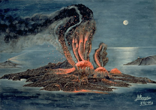 An eruption from 1939 to 1941 began with submarine explosions and lava effusion on the west coast of Nea Kameni Island, seen in this painting viewed from the NE. Over the next two years lava effusion near the center of the island, sometimes accompanied by explosive activity, produced a group of small lava domes and lava flows that traveled dominantly to the east and west. This marked the last major stage in the growth of Nea Kameni Island.
From the collection of Maurice and Katia Krafft.
 A volcanic cone forms low islands within the largely submerged, 7.5 x 11 km caldera of Santorini (Thera), as viewed from the town of Firá, on the east rim of the caldera. Santorini volcano consists of four partially overlapping calderas, the youngest of which was produced by a major eruption during the Minoan period about 3500 years ago. The Akrotíri Peninsula (upper right) and the small island in the middle distance are parts of the opposite caldera wall. Eruptions from the post-caldera cone have been recorded from 197 BCE until 1950.
Copyrighted photo by Katia and Maurice Krafft, 1989.
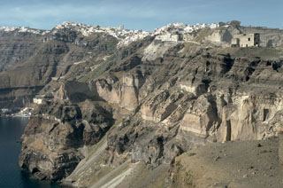 The steep eastern caldera walls of Santorini are draped by the town of Firá, many of which were built within deposits of the Minoan eruption that took place about 3,500 years ago. The most prominent unit in the caldera wall at this location is the Middle Tuff Sequence, the lighter-colored, cliff-forming unit halfway up the wall that is composed of a basal pumice deposit overlain by breccia and pyroclastic flow deposits. The Middle Tuff and the darker bedded layers overlying it were deposited during late-Pleistocene eruptions.
Photo by Lee Siebert, 1994 (Smithsonian Institution).
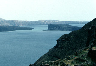
 The steep inner walls of Santorini drop steeply into the caldera bay. Pyroclastic flow deposits from four caldera-forming eruptions dating back to 100,000 years ago are exposed in the caldera walls in this N-looking view. The youngest caldera was formed about 3,500 years ago during the Minoan eruption of Santorini. The flat-topped peak on the left skyline is Skaros, a remnant of a shield volcano constructed within a previous caldera.
Photo by Lee Siebert, 1994 (Smithsonian Institution).
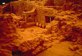 Excavations at Akrotíri have provided insights into life in a Minoan city that was buried by the catastrophic Late Bronze Age eruption of Santorini about 3500 years ago. Strong earthquakes prompted the residents of Akrotíri to evacuate the city between the time of the first minor ash falls and the devastating eruption that followed. The city was partially buried by heavy falls of ash and pumice, and then overtopped by pyroclastic flows.
Copyrighted photo by Katia and Maurice Krafft, 1989.
 Wave erosion has exposed a cross section through bedded scoria units of the Cape Mavrorachidi scoria cone on the SW side of Thera Island. Behind the cone to the left are exposures of light-colored rhyodacitic tuffs of the Akrotiri Peninsula. A 451,000 ± 27,000 BP (before present) Argon-Argon date was obtained from a lava flow from the Cape Mavrorachidi cone.
 Photo by Lee Siebert, 1994 (Smithsonian Institution).
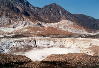 The tuff cone and crater in the foreground were formed during an eruption on the caldera floor in 1871. Phreatic explosions ejected ash and lapilli that covered the caldera floor. Five explosion craters are located in the 800 x 1,400 m caldera floor. Post-caldera lava domes form the horizon.
Photo by Ichio Moriya (Kanazawa University).
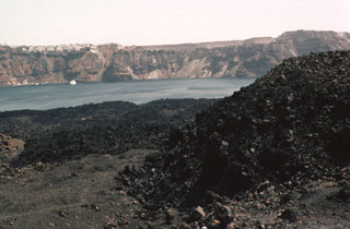
 The lava flow forming the peninsula (center) dates back to an eruption during 1707-1711. Nea Kameni Island was formed between Palaea and Mikri Kameni islands during alternating explosive and effusive activity that began with uplift of a small islet called Aspronisi (White Island). The islands of Thirasia (left) and Thira (right) along the caldera rim can be seen in the distance to the NW.
Photo by Lee Siebert, 1994 (Smithsonian Institution)
 The dacitic lava flow at the right is part of the Dafni lavas, erupted early in the course of an eruption that lasted from 1925 to 1926. Like many other of Santorini's post-caldera eruptions, this eruption began with submarine explosions and lava extrusion. Explosive activity produced eruption plumes up to 3.2 km high. The east wall of Santorini caldera hosts the town of Firá across the caldera bay.
Photo by Lee Siebert, 1994 (Smithsonian Institution).
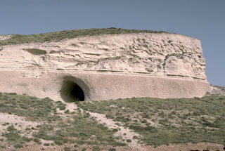
 The headland of Cape Thera above Phira harbor. The light-brown, cliff-forming unit above the harbor is the Cape Thera Ignimbrite. Above the cliffs is a sequence of sloping pyroclastic deposits and paleosols, which underlies the prominent thinner dark-colored layer at the top of the photo. This is the Middle Pumice unit, a welded Plinian pumice-fall deposit erupted about 100,000 years ago and thought to originate from a vent west of Phira. The lower-angle slopes above it are lithic breccias of the Middle Pumice eruption.
Photo by Lee Siebert, 1994 (Smithsonian Institution).
 Nisyros has a 3.6-km-diameter caldera with walls 300-400 m high and is filled with lava domes, seen here in this September 2019 Planet Labs satellite image monthly mosaic (N is at the top). The edifice also has vents, scoria cones, dikes, fault systems, and geothermal features, including active fumaroles and hot springs.
Satellite image courtesy of Planet Labs Inc., 2019 (https://www.planet.com/).
This is a compilation of Greece volcano information sources, such as official monitoring or other government agencies.
| Volcano Observatories |
|---|
| Institute for the Study and Monitoring of the Santorini Volcano (I.S.M.O.SA.V.) |
| Νational Observatory of Athens |
| - Νational Observatory of Athens Facebook |
| Civil Protection Agencies |
|---|
| Ministry for Climate Crisis and Civil Protection |
| - Ministry for Climate Crisis and Civil Protection Facebook |
| - Ministry for Climate Crisis and Civil Protection X |
| Volcanic Ash Advisory Center |
|---|
| Toulouse Volcanic Ash Advisory Center (VAAC) Notices and Archive |