Theme Collections | Chris Newhall Photos
Theme collections are galleries not specifically related to volcanic hazards, processes, research, types, or features. This includes subjects such as different satellite platforms, astronaut photos from the Space Shuttle, specific photographers, or other special collections.
Image Gallery for Chris Newhall Photos
Photos by Chris Newhall (US Geological Survey). There are 47 images available.
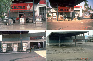 Owners of a service station in the city of Bacolor, 38 km SE of Pinatubo in the Philippines, adapted to ongoing lahars over many years; note the garage door opening at right and the height of the canopy in each photo. On 12 September 1991 (upper left), 10 days after the end of the 1991 eruption, they dug out gas pumps buried by 1-m-thick lahar deposits. By 30 November 1991 (upper right) they had raised the pumps to the new ground level. Three years later, in September 1994 (bottom left), the pumps had again been raised, to a ground surface now half the height of the original garage opening. A year later (bottom right) a 5-m-high lahar deposit filled the garage, and the station had been abandoned.
Photos by Chris Newhall, 1991-1995 (U.S. Geological Survey).
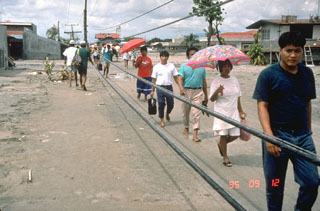 Residents of the city of Bacolor in the Philippines, 38 km SE of Pinatubo, persevere in the face of widespread devastation from lahars. They are walking on the surface of a solidified 5-m-deep deposit of volcanic debris next to wires that are the original electrical power lines formerly high above the street level. Houses and businesses in the background of this September 1995 photo are buried to 2nd-floor levels.
Photo by Chris Newhall, 1995 (U.S. Geological Survey).
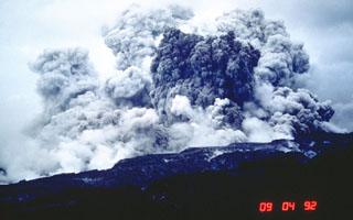 An ash plume rises several kilometers above the west flank of Pinatubo on 4 September 1992. This was not the result of an eruption, but of secondary explosions produced when water contacted still-hot pyroclastic flow deposits of the 1991 eruption. This can occur either when channel banks eroded into the deposits collapse into streams, or when groundwater invades hot deposits along buried stream channels. Ash plumes as high as 18 km were produced by these events, as well as pyroclastic flows.
Photo by Chris Newhall, 1992 (U.S. Geological Survey).
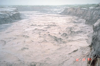 A lahar, or volcanic mudflow, fills the banks of the Pasig-Potrero River on the east side of Pinatubo volcano in the Philippines on 13 October 1991. The lahar moved at a velocity of 3-5 m/s and carried a few meter-sized boulders. This lahar was not directly produced by an eruption, but was triggered by minor rainfall that remobilized thick deposits of ash and pumice that blanketed the landscape. Devastating lahars occurred at Pinatubo for years after the catastrophic 1991 eruption.
Photo by Chris Newhall, 1991 (U.S. Geological Survey).
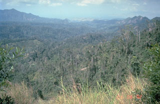
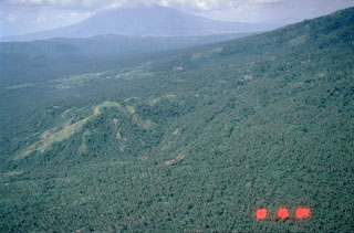
 Thick pyroclastic flow deposits from the 1991 eruption of Pinatubo were rapidly eroded in the years following the eruption. This 7 September 1994 view of the upper Marella River valley from the SW, with the caldera rim on the skyline, shows the effects of the erosion of well over 100 m of pyroclastic flow deposits. Light-colored deposits in the channels at the middle right and lower left are post-1991 lahar deposits.
Photo by Chris Newhall, 1994 (U.S. Geological Survey).
 A thick stack of pre-1991 pyroclastic flow and lahar deposits outside Clark Air Base is testimony to the long history of explosive eruptions at Pinatubo. Six major eruptive periods took place in the past 35,000 years, each separated by long periods of quiescence. Most of the previous eruptive periods produced explosions that were even larger than the 1991 eruption. The last major eruption prior to 1991 occurred about 500 years ago.
Photo by Chris Newhall (U.S. Geological Survey).
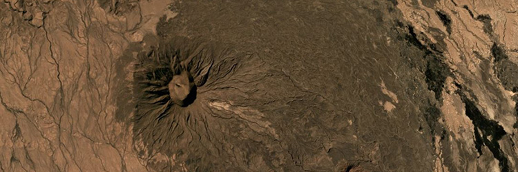
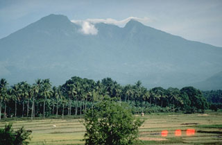
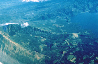
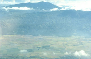
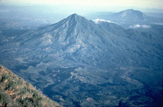
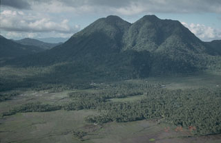
 Mount Natib is located at the northern end of the Bataan Peninsula, S of Pinatubo. The summit of the volcano, seen here from the WNW, is truncated by a 6 x 7 km caldera. The age of the latest eruption is not known, but is considered to be late Pleistocene or Holocene. Five thermal areas are found in the summit region.
Photo by Chris Newhall, 1989 (U.S. Geological Survey).
 The summit of Mount Natib, south of Pinatubo, contains a 6 x 7 km caldera seen here in this view from the NE caldera rim. Five thermal areas are found in the summit region.
Photo by Chris Newhall, 1989 (U.S. Geological Survey).
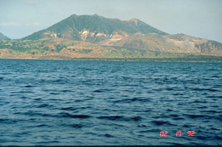 Mount Tabaro on Volcano Island at Taal is seen here from the west in 1992. The sloping ridge extending across the photo from the lower right shoreline is the rim of the elongate 1965 vent system. The dark lava flow along the coastline was erupted in 1968 from a scoria cone that formed in the 1965 vent. This and other overlapping scoria cones and craters at the right-center formed during 1966 to 1977 eruptions.
Photo by Chris Newhall (U.S. Geological Survey).
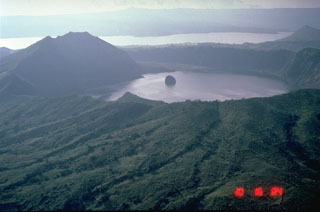
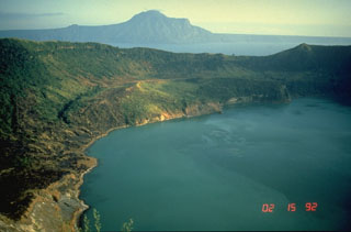 This view of Main Crater Lake in the 3-km-wide caldera on Volcano Island, looks across Lake Taal to the NE rim of the 15 x 20 km Taal caldera. The surface of the 267 km2 lake is only 3 m above sea level. Volcano Island has been the source of explosive eruptions with pyroclastic surges that devastated lakeshore areas. Pleistocene eruptions that formed the caldera greatly modified the topography of southern Luzon Island.
Photo by Chris Newhall, 1989 (U.S. Geological Survey).
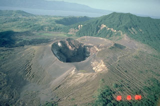 This 400-m-wide crater formed during an eruption of Taal in 1976. That eruption modified cones and craters that had been constructed during yearly eruptions from 1966 to 1970 within a larger crater that formed during the 1965 eruption. This 1984 photo from the SW also shows the small 1977 crater along the margin of the flat bench at the upper right side of the 1976 crater.
Photo by Chris Newhall, 1989 (U.S. Geological Survey).
 Taal caldera, seen here from its NW rim, is a 15 x 20 km caldera of Pleistocene and Holocene age. Volcano Island, in the north-central part of Lake Taal, is constructed of coalescing small tuff and scoria cones. Powerful phreatomagmatic explosive eruptions from several locations on the 5-km-wide island have produced deadly pyroclastic surges.
Photo by Chris Newhall, 1978 (U.S. Geological Survey).
 A 3-km-wide caldera is located at the center of Volcano Island, in the Philippines' southern Luzon Island. The 5-km-wide Volcano Island lies within the much larger 15 x 20 km Taal caldera, of which the western wall is seen across Lake Taal in the distance. The small island in the center of the photo is a remnant of historical eruptions on Volcano Island and is an island in a lake, on an island in a lake, on an island.
Photo by Chris Newhall, 1989 (U.S. Geological Survey).
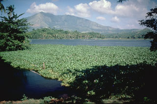
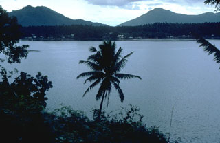 Local legends suggest that the latest eruption of the San Pablo volcanic field took place about 500-700 years ago, forming the Sampaloc Lake maar. This 1.2-km-wide maar, seen here from the S, is one of the largest of a group of 36 maars in the volcanic field.
Photo by Chris Newhall, 1989 (U.S. Geological Survey).
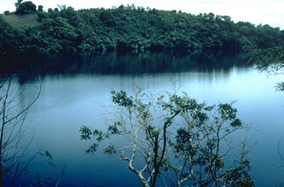 Alligator Lake, along the southern shore of Laguna de Bay, is one of a group of dozens of maars and scoria cones forming the San Pablo volcanic field (also known as the Laguna volcanic field). Three generations of maars are present, the youngest of which contain deep lakes. Many of the maars are located along a NE-SW trend. Local legends indicate that the most recent eruption occurred about 500-700 years ago at Sampaloc Lake, 17 km SE of Alligator Lake.
Photo by Chris Newhall, 1989 (U.S. Geological Survey).
 Mount Banahaw is the highest of a group of volcanoes S and E of Manila. The smaller San Cristóbal and Banáhao de Lucban have formed on the W and E flanks, respectively. This view from the SW shows a valley descending from the summit that formed or deepened during the outbreak of a crater lake in 1730. Collapse events produced two major debris avalanches, the largest of which traveled 26 km SE to the sea, where it forms a 10-km-long section of Tayabas Bay coastline.
Photo by Chris Newhall, 1989 (U.S. Geological Survey).
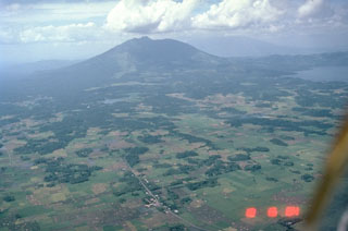
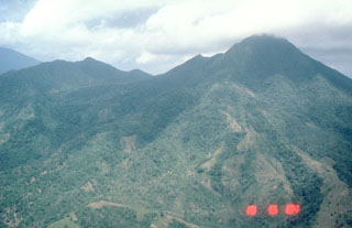
 Mount Isarog is seen in the background to the NW beyond the lower flanks of Iriga volcano in the foreground. It occupies the broad isthmus between Lagonoy Gulf and San Miguel Bay. The summit contains a large crater with a deep and narrow notch on the lower eastern flank.
Photo by Chris Newhall (U.S. Geological Survey).
 The entire foreground area in this view of Iriga volcano is a massive 1.5 km3 debris avalanche deposit formed by a Holocene landslide. This view from the SE shows the typical hummocky debris avalanche topography. Many of the darker areas are tree-covered hummocks; the irregular topography of the also creates many small ponds.
Photo by Chris Newhall (U.S. Geological Survey).
 This view looks W into the Iriga crater that formed at the base of the 600-m-high headwall scarp of a flank collapse during a Holocene eruption.
 Photo by Chris Newhall (U.S. Geological Survey).
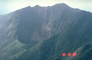
 Collapses at the summit or flanks of volcanoes during major volcanic landslides can create large horseshoe-shaped craters that open in the direction of the landslide, like this 2.1 x 3.5 km crater at Iriga in the Philippines. It was produced by a massive landslide during the Holocene. The resulting debris avalanche traveled more than 10 km to the SE and flowed into Lake Buhi at the upper right. This view is from the south, with the summit to the left.
Photo by Chris Newhall (U.S. Geological Survey).
 Mount Iriga has a horseshoe-shaped crater opening to the SE that resulted from a large flank collapse during a Holocene eruption. The hummocky terrain in the foreground encloses small ponds on the surface of the debris avalanche deposit.
Photo by Chris Newhall (U.S. Geological Survey).
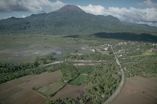
 Malinao is seen here in the background of this aerial view looking to the NE with the small town of Polangui in the foreground. It contains a summit crater that opens towards the N. The ridge in the center of the photo is the W flank of Masaraga volcano.
Photo by Chris Newhall (U.S. Geological Survey).
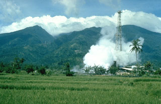 Malinao is forested with a summit crater that opens towards the east. The Tiwi geothermal field, seen here with the volcano in the background, is located on the E flank. The geothermal field is located near Luzon's largest fumarole field, which includes siliceous sinter deposits at Naglabong.
Photo by Chris Newhall (U.S. Geological Survey).
 Vegetated Masaraga, seen here from the south, is located NW of Mayon volcano. An eroded volcanic ridge extends to the NW and thick lava flows have been emplaced on the flanks
Photo by Chris Newhall (U.S. Geological Survey).
 Masaraga rises NW of Mayon volcano. This view from near the summit of Mayon also shows Mount Iriga (upper right), with its large horseshoe-shaped crater.
 Photo by Chris Newhall (U.S. Geological Survey).
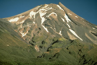
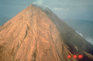 The upper flanks of the symmetrical Mayon are exceptionally steep, averaging 35-40 degrees. They are covered with solidified lava agglutinate, the molten ejecta of lava fountains. This 1984 photo from the WSW shows a 250-m-deep, 3-km-long gully in the shadow at the right that was eroded by pyroclastic flows during the 1984 eruption.
Photo by Chris Newhall, 1984 (U.S. Geological Survey).
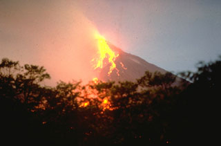 Incandescent blocks roll down the SW flanks of Mayon on 18 May 1978, seen from near Camalig on the SW flank. During the eruption a lava flow traveled a distance of more than 4 km over the top of the 1968 lava flow to about 550 m elevation. The 1978 eruption began on 7 March and continued through the summer.
Photo by Chris Newhall, 1978 (U.S. Geological Survey).
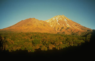
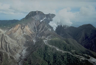
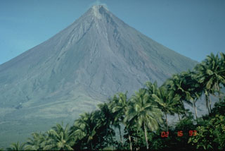 Mayon in the Philippines is one of Earth's best examples of a classic, conical stratovolcano. Its symmetrical morphology is the exception rather than the rule and is the result of eruptions that are restricted to a single central conduit at the summit. Eruptions are frequent enough to overcome erosion processes that quickly modify the slopes of most volcanoes.
Photo by Chris Newhall, 1993 (U.S. Geological Survey).
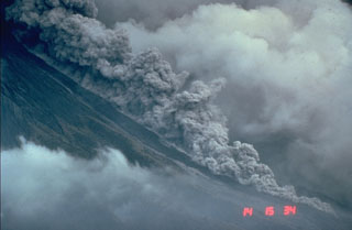 Pyroclastic flows are hot avalanches of rock, ash, and gas that sweep down the flanks of volcanoes at high velocities. This photo shows a relatively small pyroclastic flow at Mayon volcano in the Philippines on 23 September 1984. These hot, ground-hugging flows can travel at velocities to about 100 km/hour and reach areas well beyond the flanks of a volcano. Their high temperatures make them lethal to anything in their path. Hot ash plumes rise above the denser basal portion that can contain abundant solid blocks and ash.
Photo by Chris Newhall, 1984 (U.S. Geological Survey).
 The linear Pocdol Mountains lie between Saragon Bay and the Albay Gulf in southern Luzon. This view is from the S, near the town of Sosogon. A geyser and fumaroles are located near the summit. Little is known of their geologic history.
Photo by Chris Newhall (U.S. Geological Survey).
 Bulusan, seen here from the south, rises above the low-lying floor of Irosin caldera and is the youngest of several cones and lava domes constructed within the caldera. The city of Irosin is the largest community within the caldera, which formed more than 36,000 years ago. Historical eruptions of Bulusan have occurred at summit vents and flank vents also are found low on the SE side.
Photo by Chris Newhall (U.S. Geological Survey).
 Frequent eruptions have been recorded since the mid-19th century and have kept the summit of Bulusan volcano unvegetated. The principal summit crater is 300 m wide and 50 m deep, with two craters are located on the lower SE flank, the lower of which contains a crater lake.
Photo by Chris Newhall (U.S. Geological Survey).
 Mount Jormajan, a large lava dome on the east side of Bulusan volcano, was constructed at the W side of the 11-km-wide Irosin Caldera. This view from the south shows the flat caldera floor in the foreground, with the western caldera wall visible to the far left.
Photo by Chris Newhall (U.S. Geological Survey).
 The southern wall is the most prominent segment of the 11-km-wide Irosin caldera, and overlooks the flat caldera floor below the active Bulusan volcano. The northern caldera rim has been buried by the flanks of Bulusan and other post-caldera cones.
Photo by Chris Newhall (U.S. Geological Survey).
 Bulusan, seen here from the W, is the southernmost volcano on the island of Luzon. It has formed within the 11-km-wide Irosin caldera along with other cones and domes. Frequent moderate explosive eruptions have been recorded since the mid-19th century from craters at the summit.
Photo by Chris Newhall, 1984 (U.S. Geological Survey).
 Parker volcano, seen here from the E, is located at the S end of Mindanao Island in the Philippines. Reconnaissance studies of the volcano revealed resemblances to Pinatubo volcano, which also produced thick of pyroclastic flow deposits around its flanks. Parker is now thought to be the source of a major eruption in 1641 that plunged much of Mindanao into darkness.
 Photo by Chris Newhall (U.S. Geological Survey).
 Taranaki, seen here from the SW, rises above the Taranaki ring plain, with Fanthams Peak on the left. It is the youngest and SE-most of a group of volcanoes beginning with the Kaitoke Range, near the W coast of North Island. Its most recent activity, during the 15th to 19th centuries, included the eruption of ash plumes, pyroclastic flows that traveled to the NW, and emplacement of the summit lava dome.
Photo by Chris Newhall, 1986 (U.S. Geological Survey).
 Taranaki volcano (previously called Egmont) has a breached summit crater that is occupied by a partially-destroyed lava plug. This view from the SE shows the stacked lava flows that form much of the cone, with the vegetated slopes of the parasitic cone, Fanthams Peak, at the left.
 Photo by Chris Newhall, 1986(U.S. Geological Survey).
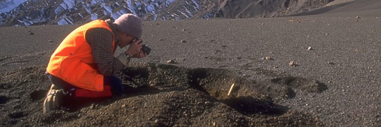
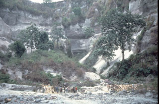
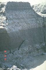 These relatively fine-grained layers are lahar deposits produced by successive overflows of dikes along the Bambam River, about 35 km NE of Pinatubo volcano in the Philippines. The photo was taken on 13 October 1991, a little more than a month after the end of the devastating 1991 eruption. Note the pen at the upper left for scale. By the end of 1991, rainfall-induced lahars had traveled 50 km down the Bambam River.
Photo by Chris Newhall, 1991 (U.S. Geological Survey).
 The unconsolidated pyroclastic flow and ash deposits emplaced during the June 1991 eruption of Pinatubo were remobilized by rain water as lahars for years after activity ceased. This photo shows erosion patterns in the deposits along the Maraunot River valley NW of Pinatubo on 27 November 1991.
Photo by Chris Newhall, 1991 (U.S. Geological Survey).
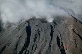
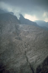
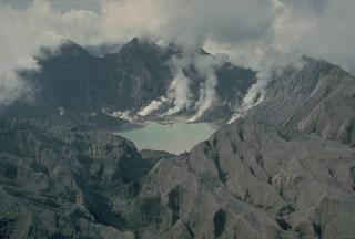 The major explosive eruption on 15 June 1991 created a 2.5-km-wide caldera at the summit of Pinatubo. The elevation of the caldera floor is more than 900 m below that of the pre-eruption summit. Plumes rise from fumaroles on the caldera floor in this 4 October 1991 photo taken from the N. The outer flanks of the caldera are stripped of vegetation and covered with ash and pyroclastic surge deposits.
Photo by Chris Newhall, 1991 (U.S. Geological Survey).
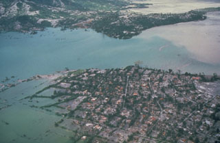 Floodwaters back up over the villages of Aglao and Dalanawan on the SW flank of Pinatubo volcano in the Philippines. Lake Mapanuepe was formed when lahars from the 1991 eruption traveled down the Marella River and dammed its tributary; several villages were submerged by the rising water. The lake was stabilized in late 1992 at about this level after excavation of a trench through bedrock, seen in the background. This prevented catastrophic rapid draining of the lake.
Photo by Chris Newhall, 1991 (U.S. Geological Survey).
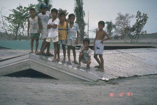 Children stand on top of a school building buried to its roof on 12 October 1991. The school was initially partially buried by lahars from Pinatubo along the Bambam River on 24 August. Successive lahars along this NE-flank valley had traveled 50 km by the end of 1991.
Photo by Chris Newhall, 1991 (U.S. Geological Survey).
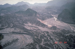
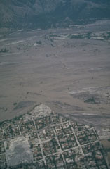 Lahars from Pinatubo fill the broad Santo Tomás River valley SW of the volcano. Erosion along the south bank of the river has cut into the town of San Rafael. This photo was taken a month after the end of the 1991 eruption. Lahars produced by the redistribution of thick deposits of ashfall and pyroclastic flows caused extensive long-term economic devastation which continued for years after the eruption ended.
Photo by Chris Newhall, 1991 (U.S. Geological Survey).
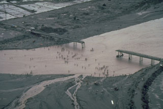 Residents in this July 1991 photo had to cross the shallow Santo Tomás River, SW of Pinatubo, on foot after lahars (volcanic mudflows) destroyed the bridge between the villages of San Rafael and Santa Fe. Devastating lahars affected broad lowland areas on all sides of Pinatubo in the years following the 1991 eruption.
Photo by Chris Newhall, 1991 (U.S. Geological Survey).
 The 1991 eruption of Pinatubo began on 2 April with a small phreatic eruption on the upper NW flank. The eruptions formed several craters along a 1.5-km-long, E-W-trending alignment. Steam rises from a vent at the SW end of the fissure. Activity continued at two of these vents through April-May and increased prior to extrusion of a small lava dome at a NW-flank vent on 7 June.
Photo by Chris Newhall,1991 (U.S. Geological Survey).
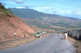
 An aerial view of the north flank of Pinatubo shows the area devastated by explosions on 2 April 1991. This eruption was the first in a progressively intensifying series of eruptions that led to caldera formation on 15 June. The road in the foreground provided access to a geothermal drill station.
Photo by Chris Newhall, 1991 (U.S. Geological Survey).