Kenya Volcanoes
A map display is currently under development.
Kenya has 21 Holocene volcanoes. Note that as a scientific organization we provide these listings for informational purposes only, with no international legal or policy implications. Volcanoes will be included on this list if they are within the boundaries of a country, on a shared boundary or area, in a remote territory, or within a maritime Exclusive Economic Zone. Bolded volcanoes have erupted within the past 20 years. Suggestions and data updates are always welcome ().
| Volcano Name | Last Eruption | Volcanic Region | Primary Landform |
|---|---|---|---|
| The Barrier | 1921 CE | Kenyan Rift Volcanic Province | Shield |
| Chyulu Hills | 1855 CE | Kenyan Rift Volcanic Province | Cluster |
| Ol Doinyo Eburru | Unknown - Evidence Credible | Kenyan Rift Volcanic Province | Composite |
| Elmenteita Badlands | Unknown - Evidence Credible | Kenyan Rift Volcanic Province | Cluster |
| Emuruangogolak | 1910 CE | Kenyan Rift Volcanic Province | Shield |
| Homa Mountain | Unknown - Evidence Credible | Kenyan Rift Volcanic Province | Composite |
| Korosi | Unknown - Evidence Credible | Kenyan Rift Volcanic Province | Shield |
| Lake Turkana Central Island | Unknown - Evidence Credible | Kenyan Rift Volcanic Province | Minor (Basaltic) |
| Lake Turkana North Island | Unknown - Evidence Credible | Kenyan Rift Volcanic Province | Minor (Basaltic) |
| Lake Turkana South Island | 1888 CE | Kenyan Rift Volcanic Province | Shield |
| Longonot | 1863 CE | Kenyan Rift Volcanic Province | Composite |
| Marsabit | Unknown - Evidence Uncertain | Kenyan Rift Volcanic Province | Shield |
| Menengai | 6050 BCE | Kenyan Rift Volcanic Province | Shield |
| Namarunu | 6550 BCE | Kenyan Rift Volcanic Province | Shield |
| Nyambeni Hills | Unknown - Evidence Credible | Kenyan Rift Volcanic Province | Shield |
| Ol Kokwe | Unknown - Evidence Credible | Kenyan Rift Volcanic Province | Shield |
| Olkaria | 1770 CE | Kenyan Rift Volcanic Province | Cluster |
| Paka | 7550 BCE | Kenyan Rift Volcanic Province | Shield |
| Segererua Plateau | Unknown - Evidence Credible | Kenyan Rift Volcanic Province | Cluster |
| Silali | 5050 BCE | Kenyan Rift Volcanic Province | Shield |
| Suswa | Unknown - Evidence Credible | Kenyan Rift Volcanic Province | Shield |
Chronological listing of known Holocene eruptions (confirmed or uncertain) from volcanoes in Kenya. Bolded eruptions indicate continuing activity.
| Volcano Name | Start Date | Stop Date | Certainty | VEI | Evidence |
|---|---|---|---|---|---|
| Lake Turkana Central Island | [1974 Jul 22 (?)] | [1974 Jul 27 ± 1 days] | Uncertain | ||
| The Barrier | 1921 Dec 31 ± 365 days | Unknown | Confirmed | 2 | Observations: Reported |
| The Barrier | [1920 ± 3 years] | [Unknown] | Uncertain | ||
| The Barrier | 1917 | Unknown | Confirmed | 2 | Observations: Reported |
| Emuruangogolak | 1910 ± 50 years | Unknown | Confirmed | 0 | Correlation: Magnetism |
| The Barrier | [1906] | [Unknown] | Uncertain | ||
| The Barrier | 1897 May (on or before) | Unknown | Confirmed | 2 | Observations: Reported |
| The Barrier | 1895 | Unknown | Confirmed | 2 | Observations: Reported |
| The Barrier | 1888 | Unknown | Confirmed | 0 | Observations: Reported |
| Lake Turkana South Island | 1888 | Unknown | Confirmed | 1 | Observations: Reported |
| The Barrier | 1871 ± 3 years | Unknown | Confirmed | 2 | Observations: Reported |
| Longonot | 1863 ± 5 years | Unknown | Confirmed | 0 | Correlation: Anthropology |
| Chyulu Hills | 1855 ± 5 years | Unknown | Confirmed | 2 | Correlation: Anthropology |
| Olkaria | 1770 ± 50 years | Unknown | Confirmed | Isotopic: 14C (uncalibrated) | |
| Emuruangogolak | 1700 ± 100 years | Unknown | Confirmed | 0 | Isotopic: 14C (uncalibrated) |
| Chyulu Hills | 1470 ± 200 years | Unknown | Confirmed | Isotopic: 14C (uncalibrated) | |
| Emuruangogolak | 1300 ± 150 years | Unknown | Confirmed | 0 | Correlation: Magnetism |
| Emuruangogolak | 1230 ± 150 years | Unknown | Confirmed | 0 | Correlation: Magnetism |
| Emuruangogolak | 1160 ± 150 years | Unknown | Confirmed | 0 | Correlation: Magnetism |
| Emuruangogolak | 1120 ± 150 years | Unknown | Confirmed | 0 | Correlation: Magnetism |
| The Barrier | 1090 ± 50 years | Unknown | Confirmed | 0 | Correlation: Magnetism |
| The Barrier | 1050 ± 150 years | Unknown | Confirmed | 0 | Correlation: Magnetism |
| The Barrier | 1030 ± 150 years | Unknown | Confirmed | 0 | Correlation: Magnetism |
| Longonot | 1330 BCE ± 100 years | Unknown | Confirmed | Isotopic: 14C (uncalibrated) | |
| Chyulu Hills | 2250 BCE ± 110 years | Unknown | Confirmed | 3 | Isotopic: 14C (uncalibrated) |
| Olkaria | 4050 BCE (?) | Unknown | Confirmed | Correlation: Tephrochronology | |
| Silali | 5050 BCE ± 2000 years | Unknown | Confirmed | Isotopic: Ar/Ar | |
| Silali | 6050 BCE ± 3000 years | Unknown | Confirmed | Isotopic: Ar/Ar | |
| Menengai | 6050 BCE (?) | Unknown | Confirmed | 6 | Isotopic: 14C (uncalibrated) |
| Olkaria | 6050 BCE (?) | Unknown | Confirmed | Correlation: Tephrochronology | |
| Emuruangogolak | 6550 BCE ± 1500 years | Unknown | Confirmed | Correlation: Tephrochronology | |
| Namarunu | 6550 BCE ± 1500 years | Unknown | Confirmed | Correlation: Tephrochronology | |
| Silali | 7050 BCE ± 2000 years | Unknown | Confirmed | Isotopic: Ar/Ar | |
| Longonot | 7200 BCE ± 100 years | Unknown | Confirmed | Isotopic: 14C (uncalibrated) | |
| Menengai | 7350 BCE ± 500 years | Unknown | Confirmed | Correlation: Tephrochronology | |
| Paka | 7550 BCE ± 2000 years | Unknown | Confirmed | 4 | Isotopic: Ar/Ar |
| The Barrier | 7710 BCE ± 200 years | Unknown | Confirmed | Correlation: Tephrochronology | |
| Emuruangogolak | 8050 BCE ± 1000 years | Unknown | Confirmed | Isotopic: 14C (uncalibrated) |
Kenya has 11 Pleistocene volcanoes. Note that as a scientific organization we provide these listings for informational purposes only, with no international legal or policy implications. Volcanoes will be included on this list if they are within the boundaries of a country, on a shared boundary or area, in a remote territory, or within a maritime Exclusive Economic Zone. Suggestions and data updates are always welcome ().
| Volcano Name | Volcanic Region | Primary Landform |
|---|---|---|
| Asie | Kenyan Rift Volcanic Province | Shield |
| Bogoria | Kenyan Rift Volcanic Province | Shield |
| Dilo-Dukana Volcanic Field | Kenyan Rift Volcanic Province | Cluster |
| Huri Hills | Kenyan Rift Volcanic Province | Shield |
| Kilombe Caldera | Kenyan Rift Volcanic Province | Caldera |
| Kulal | Kenyan Rift Volcanic Province | Shield |
| Lenderut | Kenyan Rift Volcanic Province | Caldera |
| Ol Doinyo Nyokie | Kenyan Rift Volcanic Province | Minor |
| Porr | Kenyan Rift Volcanic Province | Minor |
| Shombole | Kenyan Rift Volcanic Province | Minor |
| Sultan Hamud-Simba | Kenyan Rift Volcanic Province | Cluster |
There are 42 photos available for volcanoes in Kenya.
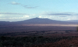
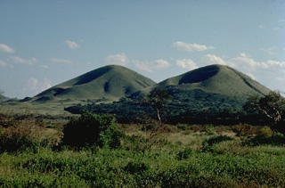 The 100-km-long NW-SE-trending Chyulu Hills volcanic field, located 150 km east of the Kenya Rift, contains several hundred small cinder cones and lava flows. Many are Holocene in age, including two that erupted during the mid-19th century. Volcanic activity began about 1.4 million years ago with eruptions in the northern Chyulu Hills and migrated to the SE, where most of the younger cones are found.
Copyrighted photo by Katia and Maurice Krafft, 1976.
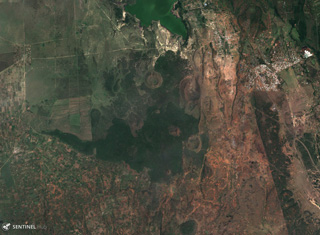
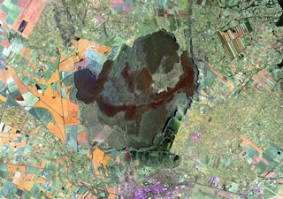
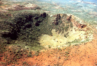
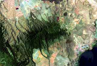
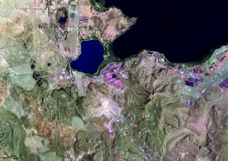
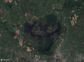 The Menengai shield volcano contains a roughly 8 x 12 km caldera with 300-m-high caldera walls, seen in this 28 November 2019 Sentinel-2 satellite image (N is at the top; this image is approximately 25 km across). Caldera formation occurred during two explosive eruptions, and since then there have been more than 70 events producing lava flows, pumice deposits, and scoria cones. The city of Nakuru lies at the bottom of the image, south of the caldera.
Satellite image courtesy of Copernicus Sentinel Data, 2019.
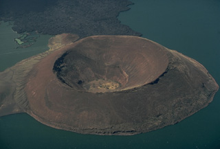
 The broad Emuruangogolak shield volcano is situated at a narrow constriction in the East African Rift. The volcano is capped by a 5 x 3.5 km wide summit caldera. The trachytic lava cone of Emuruepoli and its associated dome are visible on the N rim of the caldera. Since caldera formation about 38,000 years ago, trachytic and basaltic lava flows have been erupted within the caldera and on the flanks. The latest eruption occurred less than one hundred years ago.
Photo by Martin Smith, 1993 (copyright British Geological Survey, NERC).
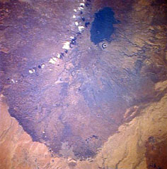
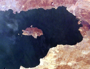
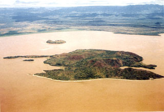
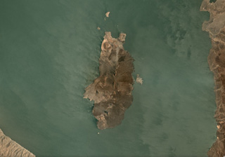
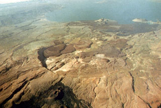
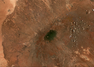
 A compound lake-filled crater occupies the SW side of Central Island in the middle of Lake Turkana. A small young crater (left central) cuts the northern rim of the tuff ring, and another large crater lies behind it. These lakes partially fill craters up to 1 km wide and about 80 m deep, with the floors near sea level. The small islands (upper right) south of Central Island are part of the volcanic complex, and other cones lie beneath the lake surface.
Photo by Martin Smith, 1993 (copyright British Geological Survey, NERC).
 The small summit caldera of Longonot volcano is seen here from the NNE. A circular crater tops a symmetrical cone erupted along a N-S fissure on the upper flanks of Longonot. Fissures lower on the north flank produced the youngest eruption of the volcano during the 19th century.
 Copyrighted photo by Katia and Maurice Krafft, 1976.
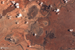
 Several scoria cones and lava flows of the Elmenteita Badlands volcanic center are visible in this 5 November 2019 Sentinel-2 satellite image (N is at the top; this image is approximately 24 km across). It contains scoria cones and lava flows of varying ages, some of which formed after the 10,000-year-old high-stand of Lake Elmenteita.
Satellite image courtesy of Copernicus Sentinel Data, 2019.
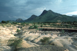 The Homa Mountain volcanic complex rises beyond an archaeological site north of the volcano in which Miocene-Pliocene hominins were excavated. Homa Mountain is a dominantly Miocene-to-Pleistocene carbonatitic complex that forms a broad peninsula on the eastern shore of Lake Victoria. Numerous flank vents include the carbonatitic and ultramafic Lake Simbi maar on the lower east flank. Oral history of inhabitants near this maar suggest that it may have been formed in historical time.
Photo by Chip Clark, 1994 (Smithsonian Institution).
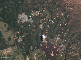 The Olkaria volcanic field contains over 80 eruption centers, some of which are visible south of Lake Naivasha in this 16 September 2019 Sentinel-2 Satellite image (N at the top). Recent activity formed the red-brown Ololbutot lava flow at the bottom of the image, which is approximately 3.5 km in the E-W direction.
Satellite image courtesy of Copernicus Sentinel Data, 2019.
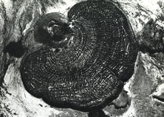
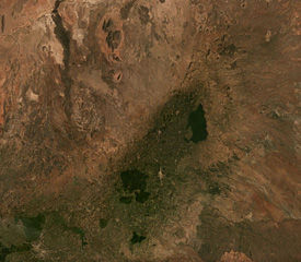
 A Space Shuttle perspective shows part of Marsabit, a massive, 6,300 km2 shield volcano located 170 km E of the center of the East African Rift. Its slopes are dotted with 180 cinder cones and 22 maars, such as the prominent circular one below the thickly vegetated summit of the shield volcano. Most of these vents are concentrated along NW- and NE-trending belts cutting across the summit. The youngest lava flows are unvegetated, and the post-shield cinder cones were mapped as Pleistocene to Holocene in age.
NASA Space Shuttle image STS026-37-2, 1988 (http://eol.jsc.nasa.gov/).
 Farmlands occupy the flanks of Menengai shield volcano on the floor of the East African Rift. A major explosive eruption about 8,000 years ago resulted in formation of the 12 x 8 km wide caldera seen in this Landsat image. More than 70 post-caldera lava flows cover the caldera floor, the youngest of which may be only a few hundred years old. Most lava flows erupted from vents near the center of the caldera and ponded against the caldera walls. The city of Nakuru lies at the bottom of the image, south of the caldera.
NASA Landsat image, 1999 (courtesy of Hawaii Synergy Project, Univ. of Hawaii Institute of Geophysics & Planetology).
 Suswa is the southernmost volcano of the Central Kenya Peralkaline Province (CKPP). The shield volcano has nested summit calderas that are visible in the center of this December 2019 Planet Labs satellite image mosaic (N at the top), with widths of 12 km for the largest caldera and 5.5 km for the inner caldera. More recent lava flows appear darker in this image.
Satellite image courtesy of Planet Labs Inc., 2019 (https://www.planet.com/).
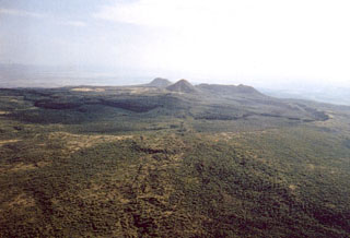
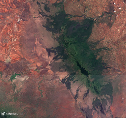 The Chyulu Hills volcanic field in southern Kenya covers an area of over 2,800 km2 and is located around 150 km E of the southern Kenya Rift Valley. More recent activity has occurred in the southern part of the field, containing a 50-km-long main central ridge with numerous cones and craters seen here in this 3 February 2019 Sentinel-2 satellite image (N at the top).
Satellite image courtesy of Copernicus Sentinel Data, 2019.
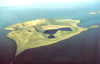
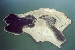
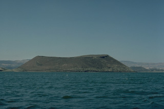
 South Island (left center) is the southernmost and largest of the three volcanic islands in Lake Turkana. North is to the left in this International Space Station view. Lava flows erupted from a fissure extending the 11-km length of the island and form much of the eastern shoreline (top). An eruption from a scoria cone on South Island was witnessed during Count von Teliki's 1888 expedition.
NASA International Space Station image ISS006-E-5095, 2002 (http://eol.jsc.nasa.gov/).
 The Barrier volcano separates Lake Turkana from the Suguta Trough to the south, the site of a former lake. The volcano is comprised of four overlapping shield volcanoes. This view looks down the north flank of the volcano with Lake Turkana at the upper right. Holocene fissure-related scoria cones and lava flows, including the historically active Teleki's and Andrew's cones (lower center), dot the volcano's southern and northern flanks. Historical eruptions have produced explosive activity and lava flows during the 19th and 20th centuries.
Copyrighted photo by Katia and Maurice Krafft, 1978.
 The central cone of Longonot volcano was constructed within a large, topographically indistinct caldera. The summit of Longonot, seen here from the north, is the west rim of a 1.8-km-wide summit caldera. Late-stage lava flows were erupted on the northern and SW flanks.
 Copyrighted photo by Katia and Maurice Krafft, 1976.
 The pristine Naboiyoton tuff cone rises above Lake Turkana in northern Kenya. The tuff cone, seen here from the north, is a satellitic cone on the north flank of The Barrier volcano. It rises 180 m above the lake, and was formed by explosive eruptions produced when magma rising up along the East African Rift encountered the waters of Lake Turkana. The age of the tuff cone is not known, but its lower slopes lack erosional terraces created during higher stands of the lake. The lava flow at the top was erupted from The Barrier volcano.
Copyrighted photo by Katia and Maurice Krafft, 1977.
 Getang crater, also known as Kinyach, is on the N side of the Korosi summit area. The walls of the 600-m-wide, 120-m-deep crater expose trachytic lava flows. The youngest activity at Korosi, consisting of fissure-fed basaltic lava flows on the lower northern flanks, may have occurred only a few hundred to a few thousand years ago.
Photo by Martin Smith, 1993 (copyright British Geological Survey, NERC).
 Prominent dark lava flows (center) erupted from vents in the Elmenteita Badlands, located between Lake Elmenteita (top) and Eburru volcano, the flanks of which appear at the bottom of this Landsat image. Cones and lava flows of varying ages are visible, some of which post-date the 10,000-year-old high-stand of Lake Elmenteita and are of Holocene age.
NASA Landsat image, 1999 (courtesy of Hawaii Synergy Project, Univ. of Hawaii Institute of Geophysics & Planetology).
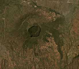
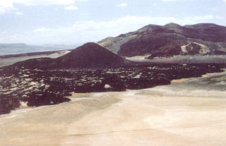
 Muruese (upper left) is a breached cone on the lower SW flank of Paka volcano. It fed this lobate trachytic lava flow that is 2 km long and 2.5 km wide. The flow is bounded by steep margins and displays prominent concentric pressure ridges. The dominantly Pleistocene Paka shield volcano in the Gregory Rift contains a small 1.5-km-wide summit caldera that is cut on the SE by a large crater.
Photo by Hunting Aereo Surveys (published in Green and Short, 1971).
 North Island in the north-central part of Lake Turkana is the northernmost and smallest of three volcanic islands in the lake. The two darker lava flows originated from a central tuff ring and formed lava deltas. The broad northern flow (left) originated from a vent on the flank and produced a 900-m-wide, lobate delta. The western flow (lower right) moved from the central vent through a breach in the western crater wall. Fumarolic activity occurs along the light-colored ridge at the top and along the SW coast.
Photo by Martin Smith, 1993 (copyright British Geological Survey, NERC).
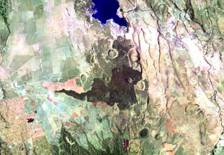
 Cones, maars, lava flows, and craters of the Dilo-Dukana Field are visible in this December 2020 Planet Labs satellite image mosaic (N at the top; this image is approximately 104 km across) along the Ethiopia-Kenya border, which crosses roughly NW-SE through the view. The most prominent feature in the southern part of the field is the 1.8-km-wide Gof Dukana maar in Kenya, just SW of the center of the image.
Satellite image courtesy of Planet Labs Inc., 2020 (https://www.planet.com/).
 Ol Kokwe Island in Lake Baringo is seen in an aerial view looking W towards the Saimo escarpment of the rift margin. The elongated Island consists of young basaltic scoria cones that cap a trachytic shield volcano. N-S-trending faults cut the island, forming the double-tipped peninsula in the foreground and the narrow peninsula at the left center. The smaller island beyond Ol Kokwe is Parmalok, a tuff cone that fed a small lava flow.
Photo by Martin Smith, 1993 (copyright British Geological Survey, NERC).
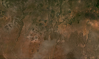
 Part of the Segererua Plateau is shown in this 21 September 2019 Sentinel-2 satellite image (N is at the top; the image is approximately 23 km across). The plateau contains lava flows, maars, and craters along an area approximately 50 km in length. Several craters are visible across this image.
Satellite image courtesy of Copernicus Sentinel Data, 2019.
 The broad NE-SW-trending Nyambeni Hills shield volcano cuts diagonally across this NASA Landsat image from the center to the upper right. It is located NE of the eroded Pleistocene Mount Kenya volcano (lower left) and is capped by numerous phonolitic lava domes and basaltic cones and lava flows. The basaltic scoria cones are the youngest features of Nyambeni Hills volcano and are clustered in a NE-trending belt along the crest of the shield and in N-S-trending areas on its flanks.
NASA Landsat image, 1999 (courtesy of Hawaii Synergy Project, Univ. of Hawaii Institute of Geophysics & Planetology).
 The South Island is the southernmost of three volcanic islands within Lake Turkana in northern Kenya, at 11 x 5.5 km plus smaller islands around the main exposed landmass, seen here in this September 2019 Planet Labs satellite image monthly mosaic (N is at the top). Lava flows form much of the surface and a fissure runs along the center of the island. Smaller cones and craters are also visible, with a larger crater at the northern end of the island.
Satellite image courtesy of Planet Labs Inc., 2019 (https://www.planet.com/).
 South Island (right) is the southernmost and largest of the three volcanic islands in Lake Turkana. The island (sometimes referred to as Hohnel Island) contains numerous cones and rises 320 m above the lake surface. Lava flows erupted from a N-S fissure extending the 11-km length of the island. An eruption from a scoria cone on South Island was witnessed during Count von Teliki's 1888 expedition.
Photo by Doron, 1999 (http://commons.wikimedia.org/wiki/Image:LakeTurkanaSouthIsland.jpg).
 Suswa is a broad low shield volcano that is cut by the southernmost caldera of the Kenya rift. The 8 x 12 km caldera is filled by a broad lava cone. An unusual 5-km-wide ring graben, seen here from the west, cuts the lava cone. The ring graben isolates a tilted island block (left). Ol Doinyo Nyukie ("The Red Mountain") forms the summit of Suswa volcano (right). The latest eruptions of Suswa have originated from parasitic vents that have issued still-unvegetated lava flows that may be only a century or so old.
Copyrighted photo by Katia and Maurice Krafft, 1976.
 The central cone of Longonot volcano is truncated by a small steep-walled caldera that is 1.8-km wide. Erosionally furrowed ash deposits related to the caldera-forming eruptions mantle its slopes. Trachytic lava flows up to 30-m thick that built the central cone can be seen in the far west caldera wall. The caldera floor is covered by post-collapse aa lava flows . A line of small craters extends from the SW wall to the center.
Copyrighted photo by Katia and Maurice Krafft, 1976.
 Vegetated Eburru volcano (center) is elongated perpendicular to the Gregory Rift NW of Lake Naivasha (lower right). The E-W-trending main edifice is eroded, but young craters cut the E part of the summit ridge and probably-Holocene rhyolitic domes occur on the E flank. Extensive fumarolic activity occurs at scoria cones and craters constructed along faults cutting the massif. Lava flows of the Elmenteita Badlands are visible at the top-center portion of this Landsat image.
NASA Landsat image, 1999 (courtesy of Hawaii Synergy Project, Univ. of Hawaii Institute of Geophysics & Planetology).
 Longonot as seen from the flanks of Suswa volcano (SSW of Longonot) in the Eastern Rift Valley of Kenya. The modern cone was constructed within a broad 8 x 12 km caldera and itself contains a smaller 1.8-km-wide summit crater that gives the summit a flat profile. Post-caldera lavas are found on the caldera floor and on the flanks. Masai tradition records a lava flow on the N flank during the 19th century.
Photo by Tom Jorstad, 1990 (Smithsonian Institution).
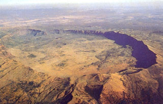
 A northward-looking aerial view shows the summit caldera of Kakorinya volcano of The Barrier volcanic complex with Lake Turkana in the distance. The 3.8-km-wide summit caldera was formed about 92,000 years ago, and post-caldera lava domes and flows fill much of the caldera floor. Fresh-looking lava flows and tuff cones occur along the shores of Lake Turkana. Teleki's Cone on the northern flank and Andrew's Cone (lower left foreground) on the southern flank have been the source of historical lava flows.
Photo by Martin Smith, 1993 (copyright British Geological Survey, NERC).
 Basaltic lavas, scoria cones, and tuff deposits were erupted along the eastern base of Namarunu volcano along the axis of the East African Rift. This view looks S with the rift margin escarpment of the Tirr Tirr Plateau in the distance at the upper left. Numerous fissure-controlled scoria cones and lava flows, as well as partially or completely below lake level tuff cones, tuff rings, and pillow lavas were erupted along the flanks of the volcano. The youngest eruptions postdated the drying out of Lake Sugata about 3,000 years ago.
Photo by Martin Smith, 1993 (copyright British Geological Survey, NERC).
 Vents of the northern part of the Olkaria volcanic complex are visible immediately S of Lake Naivasha (upper right). It comprises up to 80 individual rhyolitic centers, many of which are visible in this Landsat image. The youngest known eruption has a radiocarbon age of about 180 years. Fumarolic activity occurs at the Njorowa Gorge and at the Orengingnai and Orkaria (Olgaria) pumice cones.
NASA Landsat image, 1999 (courtesy of Hawaii Synergy Project, Univ. of Hawaii Institute of Geophysics & Planetology).
 The central caldera of Suswa, the southernmost caldera of the Kenya rift, contains a 5-km-wide caldera. Construction of an early shield volcano was followed by eruption of voluminous pyroclastic flows and lava flows that accompanied formation of the caldera. The latest eruptions have originated from vents that have issued still-unvegetated lava flows that may be only a century or so old. N is to the top in this NASA Landsat image.
NASA Landsat 7 image (worldwind.arc.nasa.gov)
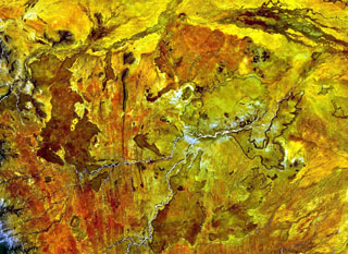 The Segererua and Rusarus Plateaus, right of the center of this NASA Landsat image (with north to the top) contain a large number of late-Pleistocene to Holocene basaltic cones, lava flows, and maars. The Milgris River cuts across the top of the image, and Merille River lies just below the center of the image. Other vents lie east of the Kauro River (bottom center). Plateau basalts are also visible at the right-center.
NASA Landsat 7 image (worldwind.arc.nasa.gov)
 The broad NE-SW-trending Nyambeni Hills volcanic field is seen across this February 2019 Planet Labs satellite image mosaic (N is at the top; this image is approximately 80 km across). The field contains numerous scoria cones, craters, and lava flows across an area approximately 50 km in length, with the youngest features near the center.
Satellite image courtesy of Planet Labs Inc., 2019 (https://www.planet.com/).
 The 6,300 km2 Marsabit volcanic field contains around 550 identified features including cones, vents, and maar craters, shown in this September 2019 Planet Labs satellite image monthly mosaic (N is at the top; this image is approximately 100 km across). The crater immediately south of the darker area in the center of the image is approximately 2.5 km in diameter.
Satellite image courtesy of Planet Labs Inc., 2019 (https://www.planet.com/).
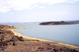
 Naboiyoton tuff cone is seen here across Lake Turkana from the NE with The Barrier shield volcano in the background. The steep slopes and wide crater of the tuff cone produce a flat-topped profile, which is typical of tuff cones. This results from powerful phreatomagmatic eruptions produced by the interaction of magma and water. The Barrier volcano draws its name from its prominent topographic position astride the East African Rift between Lake Turkana and the Sukota Trough to the south.
Copyrighted photo by Katia and Maurice Krafft, 1978.
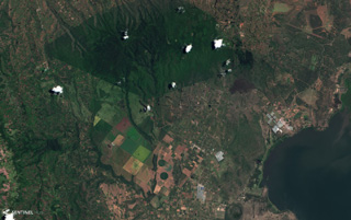 Ol Doinyo Eburru is across the center of this December 2020 Planet Labs satellite image monthly mosaic (N is at the top; this image is approximately 19 km across). It is composed of two eroded eastern (younger) and western (older) edifices, and the smaller vegetated Cedar Hill below the easternmost boundary with visible pressure ridges along the surface (lower right).
Satellite image courtesy of Planet Labs Inc., 2020 (https://www.planet.com/).
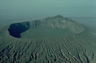
 Trachytic pumice cones drape the upper NE flanks of Paka volcano in this view from the NW. The dark-colored trachytic lava flow with visible flow ridges at the lower right traveled down the N flank through a breach in the caldera wall. The 1.5-km-wide summit caldera is visible to the upper right, and a large crater to the SE appears to its left. Areas with brown vegetation are geothermally active.
Photo by Martin Smith, 1993 (copyright British Geological Survey, NERC).
 The trachytic Longonot stratovolcano SE of Lake Naivasha contains an 8 x 12 km caldera. A large central cone, seen here from the SW, was constructed within the caldera and forms the summit of the volcano. It is truncated by a circular, 1.8-km-wide caldera. Post-caldera lavas erupted onto its floor give it a flat surface. Masai tradition records a lava flow on the northern flank during the 19th century. Similarly youthful-looking lava flows occur on the SW flank.
 Copyrighted photo by Katia and Maurice Krafft, 1976.
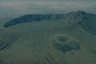
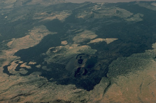
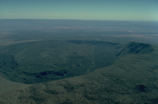
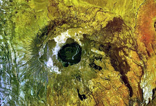
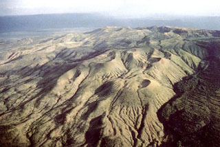
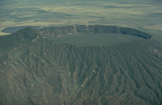
 The impressive 5 x 8 km summit caldera of Silali volcano is seen in an aerial view from the SE. Formation of the 300-m-deep caldera is related to the incremental eruption of basaltic and trachytic lava flows about 63,000 years ago. N-S-trending rift valley faults cutting across the volcano can be seen at the lower left. Some of cones on the caldera floor and flanks may be little more than a few hundred years old.
Photo by Martin Smith, 1993 (copyright British Geological Survey, NERC).
This is a compilation of Kenya volcano information sources, such as official monitoring or other government agencies.
| Volcanic Ash Advisory Center | |
|---|---|
| Toulouse Volcanic Ash Advisory Center (VAAC) Notices and Archive | |