The Washington VAAC reported that ash plumes from San Cristóbal were visible in webcam images at around 1500 and 1700 on 7 June rising above the summit and drifting N. The plumes were not identified in satellite images due to weather conditions. According to a news report the ash plume rose 1 km above the summit.
Sources: Washington Volcanic Ash Advisory Center (VAAC), Centinela35
Strong explosion with an ash plume, pyroclastic flows, and ashfall on 5 July 2023
San Cristóbal (also known as El Viejo), is located in Nicaragua and consists of five principal volcanic edifices that form the NW end of the Marrabios Range. Recorded eruptions date back to 1528, with more frequent eruptions occurring over the last 50 years. The most recent eruption period began in December 2020 and was characterized by small ash explosions and gas-and-steam emissions (BGVN 47:09). This report describes a short, one-day eruption on 5 July 2023, according to the Instituto Nicaragüense de Estudios Territoriales (INETER) and Sistema Nacional para la Prevención, Mitigación y Atención de Desastres (SINAPRED).
Activity during September 2022 through June 2023 was low, according to INETER; gas-and steam emissions and seismicity were still sometimes registered. Monitoring data reported by INETER consistently included the average sulfur dioxide levels (tons/day) and the total number of earthquakes per month, a small number of which were volcano-tectonic (VT) events (table 10). Tremor generally remained within 60-160 RSAM (Real-Time Seismic Amplitude Measurements); during June RSAM units were 60-1,200 and during 26 June through 5 July they were 200-400.
Table 10. Monthly sulfur dioxide measurements and seismicity reported at San Cristóbal during September 2022 through July 2023. Courtesy of INETER.
| Month | Average SO2 | Total earthquakes | Volcano-tectonic (VT) earthquakes |
| Sep 2022 | 334 t/d | -- | -- |
| Oct 2022 | 310 t/d | 4,260 | 260 |
| Nov 2022 | 432 t/d | 2,931 | 0 |
| Dec 2022 | -- | -- | -- |
| Jan 2023 | -- | -- | -- |
| Feb 2023 | -- | -- | 0 |
| Mar 2023 | 89 t/d | 6,319 | 0 |
| Apr 2023 | 63 t/d | 5,831 | 0 |
| May 2023 | 342 t/d | 6,978 | 0 |
| Jun 2023 | 479 t/d | 40,185 | 0 |
| Jul 2023 | 1,281 t/d | 17,964 | 0 |
Approximately 40,185 seismic events were recorded during June, with the RSAM units fluctuating between 60 up to 1,200. On 4 June, tremor increased and remained elevated until 8 June. Tremor declined to background levels until 21 June, when another increase was noted and remained elevated for several weeks.
During July the number of earthquakes decreased compared to June, with 17,964 registered. On 5 July at 1705 an explosion was reported that lasted a few minutes. A gas-and-ash plume rose 2 km above the crater and drifted SW and W (figure 47). Ashfall was reported in Las Grecías (12 km WSW), La Bolsa, and other smaller surrounding communities, according to data corroborated by the Risk Management unit of the Mayor’s Office of Chinandega. Pyroclastic flows were reported at the summit traveling 1 km, based on an analysis of Sentinel-3 images. The sulfur dioxide emissions rose as high as 1,281 t/d on 12 July, based on measurements using the Mobile DOAS technique. The eruption damaged crops and burned plants and grass in the area surrounding the volcano (figure 48). According to a Sentinel image captured on 9 July a narrow, dark deposit extended about 10 km W from the summit crater.
 |
Figure 47. Photo of the ash plume rising 2 km above the crater at San Cristóbal that drifted SW and W on 5 July 2023 following an explosion. Pyroclastic flows were also visible near the summit of the volcano. Courtesy of SINAPRED. |
 |
Figure 48. Photos of the ash plume that rose 2 km above the crater and resulting ashfall in Chinandega from the eruption on 5 July 2023 at San Cristóbal and the damage to vegetation around the volcano. Courtesy of the mayor of Chinandega and Fausto Tijeríno, INETER (Boletín Sismos y Volcanes de Nicaragua, Julio, 2023). |
Thermal activity was relatively low since June 2022; according to the MIROVA (Middle InfraRed Observation of Volcanic Activity) graph, four thermal anomalies were detected during March through June 2023 (figure 49). Infrared satellite images showed occasional small hotspots in the summit crater during April through July 2023 (figure 50).
 |
Figure 49. Four thermal anomalies (red dots) were detected at San Cristóbal during March through June 2023, as recorded by the Landsat 8 and 9 satellite using OLI/SWIR bands 7, 6, 5. Courtesy of MIROVA. |
 |
Figure 50. Infrared (bands B12, B11, B4) satellite imagery showed a weak thermal anomaly at the summit crater on 16 April 2023 (top left), 6 May 2023 (top middle), 15 June 2023 (top right), 25 June 2023 (bottom left), 30 June 2023 (bottom middle), and 5 July 2023 (bottom right). Courtesy of Copernicus Browser. |
Information Contacts: Instituto Nicaragüense de Estudios Territoriales (INETER), Apartado Postal 2110, Managua, Nicaragua (URL: http://www.ineter.gob.ni/); Sistema Nacional para la Prevencion, Mitigacion y Atencion de Desastres (SINAPRED), Edificio SINAPRED, Rotonda Comandante Hugo Chávez 50 metros al Norte, frente a la Avenida Bolívar, Managua, Nicaragua (URL: http://www.sinapred.gob.ni/); MIROVA (Middle InfraRed Observation of Volcanic Activity), a collaborative project between the Universities of Turin and Florence (Italy) supported by the Centre for Volcanic Risk of the Italian Civil Protection Department (URL: http://www.mirovaweb.it/); Copernicus Browser, Copernicus Data Space Ecosystem, European Space Agency (URL: https://dataspace.copernicus.eu/browser/).
2024: June
2023: July
2022: June
2021: February
| March
| December
2019: March
2018: April
2017: August
| September
| November
2016: April
2015: June
2014: January
| February
| April
2013: June
2012: September
| December
2011: January
| August
2010: June
| August
| December
2009: May
| September
| December
2008: June
| July
| November
2006: March
| April
2005: November
2002: March
| May
| August
| October
| December
2001: May
| June
| August
| November
The Washington VAAC reported that ash plumes from San Cristóbal were visible in webcam images at around 1500 and 1700 on 7 June rising above the summit and drifting N. The plumes were not identified in satellite images due to weather conditions. According to a news report the ash plume rose 1 km above the summit.
Sources: Washington Volcanic Ash Advisory Center (VAAC); Centinela35
SINAPRED reported that on 5 July a small explosion at San Cristóbal produced a moderately-sized ash-and-gas plume. The emissions in photos posted by SINAPRED appeared to be dense and gray, and pyroclastic flows were visible on the upper flanks. According to news articles, a strong sulfur odor was reported in nearby communities along with the fall of ash and larger tephra, most notably in La Grecia (12 km WSW). Fine ash particles in the air continued to impact residents the next day. A dark narrow deposit extending about 10 km W from the summit crater was visible in a 9 July Sentinel satellite image.
Sources: Sistema Nacional para la Prevención, Mitigación y Atención de Desastres (SINAPRED); La Prensa (Nicaragua); Sentinel Hub; European Pressphoto Agency
According to a news article, INETER reported that at 0751 on 26 June a moderate explosion at San Cristóbal produced a gas-and-ash plume that rose 1.5 km above the crater rim and drifted WSW. A minor amount of ash fell in the communities of La Grecias 3 and Las Grecias 4 (12 km WSW), and the city of El Viejo (18 km WSW). RSAM data spiked during the explosion and then returned to normal levels afterwards.
Source: Viva Nicaragua – Canal 13
INETER reported that a series of five low- to medium-intensity explosions were recorded at San Cristóbal between 0522-0526 on 15 December. Ash plumes rose 2.5 km above the crater rim and drifted W, causing ashfall in La Grecia, Rancherías (8 km NW), and El Viejo (18 km SW). Rocks were ejected 500 m from the vent onto the flanks.
Source: Instituto Nicaragüense de Estudios Territoriales (INETER)
The Washington VAAC reported that on 19 March a notable ash cloud from San Cristóbal rose at least to 12.2 km (40,500 ft) a.s.l. and drifted over 80 km ENE based on satellite data, ash dispersion models, and weather models.
Source: Washington Volcanic Ash Advisory Center (VAAC)
SINAPRED reported that a series of five explosions at San Cristóbal were recorded during 1306-1332 on 9 March. The strongest explosion, at 1325, produced an ash plume that rose 800 m above the crater rim. Ashfall as deep as 2 mm was reported in El Viejo (19 km WSW), Chinandega (16 km SW), and Chichigalapa (16 km S); ash also fell in other communities downwind including Las Grecias, La Mora, and La Bolsa.
Source: Sistema Nacional para la Prevención, Mitigación y Atención de Desastres (SINAPRED)
The Washington VAAC reported that on 14 February an ash cloud from San Cristóbal rose to 2.3 km (7,500 ft) a.s.l. and drifted SW based on satellite data, webcam images, and weather models. A thermal anomaly was also identified.
Source: Washington Volcanic Ash Advisory Center (VAAC)
INETER reported that a low-energy explosion at San Cristóbal was detected by the seismic network at 1550 on 4 March. The event produced a gas-and-ash plume that rose 400 m above the crater rim and drifted SW.
Source: Instituto Nicaragüense de Estudios Territoriales (INETER)
INETER reported that at 1320 on 22 April a small explosion at San Cristóbal generated a gas-and-ash plume that rose 800 m and drifted SW, causing ashfall in the La Bolsa region and Hacienda Las Rojas.
Source: Instituto Nicaragüense de Estudios Territoriales (INETER)
INETER reported that a series of 14 explosions at San Cristóbal began at 2134 on 7 November. The first explosion was the strongest, causing an increase in RSAM to 150 units; RSAM dropped to 50 after the last explosion. Ash fell in areas to the W and NE, including in the communities of Los Farallones, San Agustín, La Mora, El Naranjo, and Chinandega.
Source: Instituto Nicaragüense de Estudios Territoriales (INETER)
Based on seismic data INETER reported that a period of tremor recorded at San Cristóbal during 1939-2005 on 9 September ended with an explosion signal.
Source: Instituto Nicaragüense de Estudios Territoriales (INETER)
According to a news report, at 0518 on 18 August SINAPRED received reports of ash fall in some communities near San Cristóbal, including La Grecia, and the municipalities of El Viejo (18 km WSW) and El Realejo (25 km SW). Based on analysis of satellite images and information from INETER, the Washington VAAC reported that a small ash puff from the volcano rose 300 m above the crater rim and drifted NW. Later that day a gas emission possibly containing ash rose 300 m and drifted W. An ash plume identified in satellite images extended as far as 265 km W. Seismicity was elevated. Steam-and-gas emissions continued through the rest of the day.
Sources: Washington Volcanic Ash Advisory Center (VAAC); El 19 Digital
INETER and SINAPRED reported that at 1020 on 22 April an explosion at San Cristóbal produced an ash-and-gas plume that rose 2 km above the crater and drifted SW. The seismic network recorded 10 additional explosions by 1200. Ashfall was reported in local areas including Las Brisas (10 km S), San José (8 km SSE), Santa Narcisa, Pellizco Central (12 km SSE), Los Ébanos, Los Lirios (18 km WSW), Santa Cruz (35 km SE), Las Grietas (14 km E), El Liberal, and San Lucas (13 km E). The INETER report noted that the last explosive activity occurred on 6 June 2015, though explosions that day were of lesser magnitudes.
Sources: Instituto Nicaragüense de Estudios Territoriales (INETER); Sistema Nacional para la Prevención, Mitigación y Atención de Desastres (SINAPRED)
INETER reported that at 0907 on 12 June an explosion at San Cristóbal generated a gas-and-ash plume that rose 2 km and drifted SE. An explosion at 1835 produced a gas plume with low ash content; the height of the plume was unable to be determined due to inclement weather. INETER noted that seismicity remained at background levels. Seismic signals detected a lahar between 1850 and 1929; an observer reported that the small lahar descended the W and SW flanks.
Source: Instituto Nicaragüense de Estudios Territoriales (INETER)
According to INETER about 41 gas explosions occurred at San Cristóbal between 1354 and 1625 on 6 June. The strongest one occurred at 1355, and generated an ash plume that rose 200 m above the crater rim and drifted SE. After the short period of increased activity, San Cristóbal returned to a calm state.
Source: Instituto Nicaragüense de Estudios Territoriales (INETER)
Based on analysis of satellite images, the Washington VAAC reported that on 11 April a gas plume from San Cristóbal that possibly contained small amounts of ash drifted 20 km W. A thermal anomaly was present in short-wave infrared satellite images. Periods of elevated seismicity were also detected.
Source: Washington Volcanic Ash Advisory Center (VAAC)
INETER reported that a gas emission with small amounts of ash rose from San Cristóbal between 0641 and 0850 on 4 February. Although there was no increase noted, the report stated that seismicity decreased to background levels. By the afternoon sulfur dioxide emission values were 2,000-3,000 tonnes per day, the normal levels, and on 7 February they were 1,000 tonnes per day.
Source: Instituto Nicaragüense de Estudios Territoriales (INETER)
INETER reported that seismic tremor at San Cristóbal increased at 0340 on 17 January; RSAM values increased from a baseline of 70 to 460 units. Twelve gas emissions were observed between 1259 and 1315, and RSAM climbed to 649 units. A report at 1700 noted that RSAM values decreased to 100 and no additional gas emissions were observed. The next day, 18 January, RSAM values fluctuated between 90 and 190 units.
Source: Instituto Nicaragüense de Estudios Territoriales (INETER)
INETER reported that on 7 June seven explosions at San Cristóbal ejected gas and ash, and were detected by the seismic station located on the W flank. The explosions occurred at 0615, 0645, 0653, 0911, 1137, 1139, and 1143, and were also observed by civil defense and INETER staff. The largest explosion, at 1139, generated a plume that rose 100 m. Sulfur dioxide emissions, which had been low, increased. A report later that afternoon stated that gas-and-ash explosions decreased, but Real-time Seismic-Amplitude Measurement (RSAM) values almost tripled to between 80 and 100 units due to increased tremor. INETER noted that tremor is frequently detected at San Cristóbal, and for the public not to be alarmed. A small lahar occurred at 1710.
Source: Instituto Nicaragüense de Estudios Territoriales (INETER)
INETER reported that on 26 December four explosions at San Cristóbal produced ash plumes that were observed in satellite imagery drifting W and reaching the Pacific Ocean. Ashfall was reported in areas within 5-6 km of the volcano. The next day explosions produced ash plumes that rose 200 m above the crater. On 28 December gas-and-ash plumes drifted NW, W, and SW, reaching the Pacific Ocean and the coast of El Salvador. Explosions were detected until 1100. Sulfur dioxide emissions continued and drifted W and SW; the emissions decreased the next day.
Source: Instituto Nicaragüense de Estudios Territoriales (INETER)
INETER reported that on 25 December at 1800 seismicity at San Cristóbal increased. A series of explosions starting at 2000 produced ash-and-gas plumes that rose 500 m above the crater and drifted SW and likely W. Ash fell near the volcano. Seismicity increased significantly the next day. Explosions continued to generate ash-and-gas plumes that rose 2.5 km above the crater and drifted N, W, and SW as far as the Pacific Ocean (30-40 km SW and W, respectively). Ashfall was reported in areas downwind, including Puerto Morazan, Jiquilillo, Aposentillo, Tonalá, El Viejo, Santa Marta, and the cities of Chinandega, Chichigalpa, Corinth, and Realejo. According to news articles, some families near the volcano self-evacuated.
Sources: Instituto Nicaragüense de Estudios Territoriales (INETER); Reuters
On 10 September, INETER reported that seismicity decreased after the 8 September eruption at San Cristóbal. Sulfur dioxide emissions had decreased since the previous day. During 10-11 September steam plumes rose 200-300 m above the crater and drifted W. Three small explosions on 11 September generated ash-and-gas plumes that rose 300 m above the crater and drifted W. An explosion and ash venting was observed a few hours later; a plume drifted S and ash fell on the flanks. The seismic network detected small explosions on 13 September. Sulfur dioxide gas emissions were above normal, and similar to levels detected on 8 September. Sulfur dioxide gas emissions increased on 14 September. The next day a small explosion was observed and gas plumes drifted NE. Gas plumes drifted N on 17 September.
Source: Instituto Nicaragüense de Estudios Territoriales (INETER)
INETER reported that on 8 September three explosions from San Cristóbal produced ash-and-gas plumes that rose 1.5 km above the crater and drifted 9 km/hr NW. Ashfall was reported in El Viejo (18 km WSW), El Chonco, and Ranchería. Sporadic explosions later that day generated ash plumes that rose 1.5-5 km and drifted 50 km WNW. Ash fell in an area covering 2,438 square kilometers, including the communities of El Viejo, La Grecia, La Joya, Santa Catalina, El Piloto, Las Banderas, Las Rojas, Carlos Fonseca, Jiquilillo, Mechapa, and Cosiguina. Ashfall was 5 cm thick in areas near the crater and up to 3 mm thick in more distant places. Sulfur dioxide emissions were 3,221 tons per day, well above the normal range of 550 to 700 tons per day. A resident near the volcano reported landslides and falling rocks in the N part of the crater. Incandescent rocks fell in areas NW, causing burns on livestock. Residents in Versalles Arriba, near the crater, reported seeing a fissure. According to a news article, officials evacuated about 3,000 people. SINAPRED reported that airplanes were diverted around San Cristóbal to other airways.
Sources: Sistema Nacional para la Prevención, Mitigación y Atención de Desastres (SINAPRED); Instituto Nicaragüense de Estudios Territoriales (INETER); Associated Press
The Washington VAAC reported that on 21 August emissions of gas and light ash from San Cristóbal were possibly detected in satellite imagery drifting 35 km WNW. Ash was not detected in subsequent images.
Source: Washington Volcanic Ash Advisory Center (VAAC)
Based on a METAR weather notice, the Washington VAAC reported a possible ash plume on 13 January. Satellite imagery showed a narrow and diffuse plume drifting SW.
Source: Washington Volcanic Ash Advisory Center (VAAC)
Based on analyses of satellite imagery, the Washington VAAC reported that on 6 January a gas-and-steam plume from San Cristóbal, possibly containing ash, drifted 25 km SW. The VAAC noted a METAR weather notice stating that "smoke" was observed.
Source: Washington Volcanic Ash Advisory Center (VAAC)
Based on a METAR weather notice from the Chinandega airport (MNCH), the Washington VAAC reported that on 23 December a 13-km-wide volcanic plume from San Cristóbal drifted 75 km SW. Additional details of the plume content were not known.
Source: Washington Volcanic Ash Advisory Center (VAAC)
According to the Washington VAAC, the San Cristóbal Volcano Observatory reported increased seismicity on 15 December and small near-summit plumes of gas and ash. Cloud cover prevented satellite observations of San Cristóbal. On 17 December a gas plume possibly containing some ash drifted less than 30 km N.
Source: Washington Volcanic Ash Advisory Center (VAAC)
Based on analyses of satellite imagery, the Washington VAAC reported that on 20 August an ash plume from San Cristóbal drifted over 35 km N.
Source: Washington Volcanic Ash Advisory Center (VAAC)
Based on analyses of satellite imagery, the Washington VAAC reported that on 9 June a well-defined ash plume from San Cristóbal drifted about 115 km WNW.
Source: Washington Volcanic Ash Advisory Center (VAAC)
Based on analyses of satellite imagery, the Washington VAAC reported that on 26 December an ash plume from San Cristóbal drifted 90 km WSW.
Source: Washington Volcanic Ash Advisory Center (VAAC)
Based on METAR weather reports, the Washington VAAC reported that on 22 December a gas-and-steam plume that rose from San Cristóbal possibly contained ash.
Source: Washington Volcanic Ash Advisory Center (VAAC)
Based on analyses of satellite imagery, the Washington VAAC reported that on 6 December a gas-and-steam plume from San Cristóbal, possibly containing ash, drifted SW. The VAAC also noted smoke from local fires.
Source: Washington Volcanic Ash Advisory Center (VAAC)
Based on analysis of satellite imagery and information from the Tegucigalpa MWO, the Washington VAAC reported that on 6 September an explosion from San Cristóbal produced an ash plume that rose to an altitude no higher than 8.5 km (28,000 ft) a.s.l. The plume drifted 75 km W. According to a news article, ashfall was reported in nearby towns.
Sources: Associated Press; Washington Volcanic Ash Advisory Center (VAAC)
Based on analysis of satellite imagery, the Washington VAAC reported that on 19 May a diffuse plume from San Cristóbal drifted 45 km SW.
Source: Washington Volcanic Ash Advisory Center (VAAC)
According to a news article, seismic activity from San Cristóbal increased on 14 and 17 November. The article also noted that INETER reported explosions and subsequent ash-and-gas emissions from the crater on 21 November. Ashfall was reported in areas to the S.
Source: Agence France-Presse (AFP)
A news article reported that San Cristóbal produced a series of small explosions on 11 July, sending a plume of gas and ash NW. The article also noted that INETER had detected a series of tremors in recent weeks.
Sources: Reuters; Instituto Nicaragüense de Estudios Territoriales (INETER)
According to news articles, seismic activity from San Cristóbal increased for multiple days, after a moderate explosion and subsequent ash-and-gas emissions from the crater on 22 June. Local authorities alerted nearby populations to be prepared for potential future activity.
Source: EFE News Service
According to news articles, INETER reported that a moderate explosion from San Cristóbal on 22 June was followed by ash-and-gas emissions from the crater. Ashfall was reported in the city of Chinandega and three other nearby communities.
Source: Terra Actualidad
Phreatomagmatic eruptions began at San Cristóbal on 21 April. Seismic tremor increased at the volcano that same day around 1300. Small explosions produced gas-and-ash plumes during 21-23 April that deposited small amounts of ash in nearby towns.
Source: Instituto Nicaragüense de Estudios Territoriales (INETER)
According to a news report, explosions on 6 March at San Cristóbal produced columns of ash and gas that rose above the volcano. The height of the plumes was not reported. The activity ceased by 8 March and there were no evacuations.
Source: Associated Press
There was an increase in seismicity at San Cristóbal beginning on 19 November. Increased tremor was interpreted as being related to gas and ash emissions. Ash fell W of the volcano and near the town of Chinandega, ~15 km SW of the volcano. The amount of tremor decreased later.
Source: Instituto Nicaragüense de Estudios Territoriales (INETER)
Based on ground observations from Chinandega, the Washington VAAC reported that relatively strong volcanic activity occurred at San Cristóbal on 16 December at 0745. INETER's volcano camera and satellite imagery showed a plume emanating from the summit that appeared to be mainly composed of steam with some possible ash.
Source: Washington Volcanic Ash Advisory Center (VAAC)
The Washington VAAC reported that on 15 October beginning at 0615 a plume was visible in satellite imagery rising from San Cristóbal. It appeared to be composed mostly of steam, but there may have been some ash present.
Source: Washington Volcanic Ash Advisory Center (VAAC)
A ground observer in Chinandega, Nicaragua indicated that San Cristóbal was active on 21 August around 1600. Ash was not visible on an INETER volcano camera at 1630 due to dense cloud cover. A possible plume was detected on satellite imagery taken at 1545 during a break in the cloud cover. The plume was estimated to be near summit level and drifted W.
Source: Washington Volcanic Ash Advisory Center (VAAC)
Volcanic tremor began to increase at San Cristóbal on 28 May, reaching a peak around noon the next day. The summit of the volcano was not visible, but satellite imagery from the Centro de Vigilancia de Ceniza Volcánica revealed that ash was emitted from the volcano. After the 29th, the amount of tremor decreased. Incandescence was visible at the crater rim on 1 June. By 3 June tremor was still relatively high.
Sources: La Prensa (Nicaragua); Instituto Nicaragüense de Estudios Territoriales (INETER)
INETER reported that on 23 May around dawn a vapor column was observed rising above San Cristóbal. The plume was attributed to rain contacting hot material in the crater. There was no indication of an increase in volcanism at San Cristóbal. According to the Washington VAAC, the plume rose ~3 km a.s.l. and drifted to the SW. For the previous few months seismicity had been at moderate levels.
Sources: Washington Volcanic Ash Advisory Center (VAAC); Instituto Nicaragüense de Estudios Territoriales (INETER)
According to several news reports, INETER stated that beginning on 10 May there was an increase in seismicity at San Cristóbal and that small explosions produced plumes composed of gas and small amounts of ash. The activity continued through at least 13 May. INETER personnel stated that the level of seismic activity was greater than activity during the December 1999 eruption.
Sources: La Prensa (Nicaragua); La Noticia; El Nuevo Diario
Seismic tremor increased at San Cristóbal beginning on the afternoon of 6 March. Strong seismicity occurred in 2- to 3-hour periods that were generally separated by less than 1 hour of less intense activity. Scientists visiting the volcano found that the amount of degassing had increased and that temperatures at the volcano were much higher than they had been for several months. Reportedly, incandescent material in the crater was reflected on the clouds above it. According to INETER, the activity at San Cristóbal was not strong enough to warrant raising the Alert Level.
Sources: La Prensa (Nicaragua); El Nuevo Diario
INETER stated that during the evening of 12 November small ash emissions took place at San Cristóbal. The emissions produced ash clouds that remained around summit level. According to the Washington VAAC, on 12 November at 1645 GOES-8 imagery showed a small area of possible ash drifting NW. According to ground observations, moderate volcanic activity occurred until 1800. Ash had dissipated by 2100 and the next day there were no ground reports of volcanic activity.
Sources: Instituto Nicaragüense de Estudios Territoriales (INETER); Washington Volcanic Ash Advisory Center (VAAC)
There was renewed volcanic and seismic activity at San Cristóbal during the week. During mid-August a gradual increase in seismic tremor and long-period earthquakes began and the amount of tremor peaked during the night of 11 August. The same night INETER personnel heard rumbling emanate from the volcano. Seismicity began to decrease on 12 August and increased again the night of 14 August, reaching the same level detected on 11 August. On 14 August incandescence was visible in the crater for the first time during the current episode. INETER stated that the lava lake in the crater illuminated gas and clouds above the summit crater. Seismic tremor gradually decreased until approximately 1400 on 17 August when strong seismic activity began again. Fumarolic activity increased during the current episode and small lagoons within the crater had dried.
Source: Instituto Nicaragüense de Estudios Territoriales (INETER)
According to news reports, on 21 June an explosion at San Cristóbal sent an ash cloud to a maximum height of 800 m. The cloud extended approximately 25 km downwind of the crater and ash fell in the town of Chinandega, ~15 km SW of the volcano.
Sources: La Noticia; El Nuevo Diario; La Prensa (Nicaragua); Instituto Nicaragüense de Estudios Territoriales (INETER)
Volcanic activity increased at San Cristóbal on 17 May, accompanied by a relatively large amount of seismic tremor. Pulses of gas-and-ash emissions were observed rising up to 100 m above the rim of the volcano's crater. Light ash fell in the town of Santa Barbara, 14 km SW of the volcano.
Sources: El Nuevo Diario; ABC News - Australian Broadcasting Corporation; Instituto Nicaragüense de Estudios Territoriales (INETER)
Reports are organized chronologically and indexed below by Month/Year (Publication Volume:Number), and include a one-line summary. Click on the index link or scroll down to read the reports.
Fumarolic activity at summit on 1-2 December
Card 1334 (22 December 1971) Fumarolic activity at summit on 1-2 December
"Beginning 3 May 1971 . . . San Cristóbal's summit crater has been the site of intense gas emissions visible from Leon and other nearby cities. From May to early July there were some reports of small explosions and minor ash or sand fallout at Chinandega (10 km SW). Sulfurous gas has been frequently reported at Hacienda Las Rojas on the volcano's western slope. Trees within the crater and on the downwind flank appear to have been killed. An expedition by Dartmouth College geologists on 30 November 1971 reached the rim of the second nested crater at the summit. Fumaroles at this location were depositing gypsum. Intense sulfurous gas emission obscured the view inside the crater. Volcanic ash probably several months old was sampled. Flight over the crater on 2 December 1971 indicated that fumarolic activity is most intense in an elongate (E-W) area in the crater, the area approximately coincident with the innermost of three pre-1971 nested craters."
"All of this is a great change from San Cristóbal's dormancy of nearly 300 years. Pre-1971 observations and air photos have shown no sign of activity. Local sources verify that the crater was the site of only weak fumarolic and mudpot activity prior to May 1971. The volcano has also been called El Viejo or Chinandega."
Information Contacts: Richard E. Stoiber, Dartmouth College.
Minor seismicity and small ash eruptions
A team from Dartmouth College visited the volcano from 12 to 30 March . . . . The level of activity was very low and static. There was no regular activity, and no big changes have occurred. Every few days there was a little shudder of superficial tremor in the volcano, and perhaps a short, spasmodic earthquake, but nothing very important. There was nothing out of character with the gradual buildup of activity that has been observed over the past couple of months.
On 9-10 March an eruption of ash drifted into the town of Chinandega, and there was a small ash eruption, mainly confined to the crater area, on 16 March at 1130. The team collected some sand from the latter eruption. Because the gases were too thick and heavy the crater could not be entered. When viewed from the air, sulfur coated everything in the crater to the point where it was actually overlapping the rim on the leeward side. The team did not get the impression that any inordinate activity was imminent at San Cristóbal.
Information Contacts: Dept. of Earth Sciences, Dartmouth College.
Significant increase in gas output
It is believed that the activity during April remained static. The gas output was about five times more than it was before the two small ash eruptions in March, and this involves a sulfur output of thousands of tons/day.
Information Contacts: R. Hazlett, Dartmouth College.
Minor ash eruption on 29 August
On 29 August San Cristóbal erupted briefly with a minor ejection of ash -- the eruption being another signal in the rise of the volcano's thermal gradient as evidenced by earlier eruptions in May 1971 and 9-10 March 1976, both of which were minor. The volcano has been quiet since the most recent eruption.
According to Richard Stoiber, both gas emission and its SO2 content increased from early 1971 to March 1976, but had declined by mid-July 1976. The ash ejection of 29 August has increased anticipation of major activity. Stoiber has been monitoring the volcano for the past 6 months, collecting condensed water samples from active fumaroles. Analysis of those samples has not yet been completed.
Information Contacts: A. Aburto Q., Instituto de Investigaciones Sísmicas.
Fume cloud still large in December
The fume cloud . . . was still very large in December, but the SO2 content of the gas had declined since the summer.
Information Contacts: R. Stoiber, Dartmouth College.
Small ash eruption
A small ash eruption . . . began on 16 October at 0800 and lasted about 45 minutes. According to local estimates, the eruption column rose about 1,500 m above the summit. Ashfall at Chinandega, near the volcano, was very slight.
Information Contacts: R. Stoiber, Dartmouth College.
Large white plume
A large white plume was observed from the air. Remote sensing of SO2 revealed very low levels as compared to records from monitoring over the last 8 years.
Information Contacts: R. Stoiber, S. Williams, and M. Bruzga, Dartmouth College.
Moderate vapor plume
A moderate vapor plume was emitted. Remote sensing showed that the SO2 content of the plume was low in comparison to recent years.
Information Contacts: R. Stoiber and S. Williams, Dartmouth College; M. Carr and J. Walker, Rutgers Univ.; A. Creusot, Instituto Nicaraguense de Energía.
Moderate vapor plume
A moderate-sized vapor plume rose continuously from the summit. Remote sensing of SO2 revealed increased flux since June 1980, but SO2 emission remained far below the levels of the mid-1970's.
Further Reference. Zapata, R., 1981, La Actividad del Volcán San Cristóbal (Nicaragua), Iniciada el 24 de Agosto de 1980; Boletín de Vulcanología (Universidad Nacional, Heredia, Costa Rica), no. 11, p. 16-18.
Information Contacts: R. Stoiber, S. Williams, H.R. Naslund, L. Malinconico, and M. Conrad, Dartmouth College; A. Aburto Q., and D. Fajardo B., Instituto de Investigaciones Sísmicas.
Gas plume becomes intermittent; elevated seismicity
The gas plume released essentially continuously since 1971 has become intermittent. Periods of energetic gas release of less than 1 hour duration were separated by periods (measured in hours) of only low fumarolic release. Shallow seismic activity continued at levels above background.
Information Contacts: R. Stoiber and S. Williams, Dartmouth College; D. de Jerez, Instituto Nicaraguense de Recursos Naturales (IRENA); D. Fajardo B., Instituto de Investigaciones Sísmicas.
Emissions of SO2 increase by an order of magnitude; high seismicity; incandescence
"A trend of decreasing SO2 emissions had been evident since the small ash eruptions of March 1976. However, San Cristóbal has suddenly reversed this trend, after being in a heightened state of seismic activity since August 1980. In late February, SO2 output increased by approximately an order of magnitude to the several thousand t/d level of the mid-1970's. Flights over the crater in mid-February and mid-March showed evidence of considerable recent slumping in the crater formed by the 1976 eruptions, especially on the N and NW walls. Fumarolic activity was evident all over the crater but was most concentrated in the S and SE margins of the floor and in the lower parts of the walls. No new fumaroles or fissures were observed outside the 1976 crater. Night observation revealed extensive incandescence over much of the crater, even more than that observed in December at Momotombo. High gas concentrations and unstable footing prevented measurement of any fumarole temperatures. Seismic activity continued at high levels, with almost continuous harmonic tremor and at least one earthquake with magnitude greater than 2 (which occurred one week before the elevated SO2 emission was detected)."
Information Contacts: R. Stoiber and S. Williams, Dartmouth College; D. de Jerez, IRENA; D. Fajardo B., Instituto de Investigaciones Sísmicas.
Medium- to high-temperature gases collected
Between 14 June and 11 July, personnel from PIRPSEV, CNRS, and the volcano observation section of IPG sampled gases from five central American volcanoes. Medium- to high-temperature gases from San Cristóbal were analyzed (table 1). Maximum gas temperatures measured were 525°C.
Table 1. Analytical mean of three mid-1981 gas samples (dry, HCl excluded) from San Cristóbal.
| Component | Mean Value |
| SO2 | 65.40% |
| CO2 | 33.93% |
| H2 | 0.31% |
| H2S | 0.33% |
| N2 | 4.35% in air |
| CO | 0.02% |
| CH4 | 65 ppm |
| He | 12 ppm |
| COS | 27 ppm |
Information Contacts: H. Delorme, Univ. de Paris; J. L. Cheminée, IPG, Paris.
Small irregular white gas plume; incandescence seen
"The volcano continued to emit a small white irregular gas plume. SO2 emission rates were measured at very low levels, similar to those reported for November 1980 and January 1981. Some caving had occurred in the summit crater since March 1981, and incandescence was again observed."
Information Contacts: R. Stoiber, S. Williams, R. Naslund, J.B. Gemmell, and D. Sussman, Dartmouth College; D. Fajardo B., Instituto de Investigaciones Sísmicas.
Very little SO2 in the plume; low seismicity
"COSPEC measurements indicated that very little SO2 was being emitted in the vapor plume. Levels were lower than any measured since San Cristóbal began emitting gases in 1971. Seismicity beneath the volcano has diminished to normal levels, but incandescence could still be observed in the crater."
Information Contacts: R. Stoiber and S. Williams, Dartmouth College; D. Fajardo B., INETER.
Small white plume almost all water vapor
"During a crater visit 9 March we found that the small white vapor plume was almost entirely made up of water vapor, with little acid gas content. We were unable to reach the fumaroles, but Bruce Gemmell of Dartmouth College measured fumarole temperatures as high as 590°C in December 1981.
Information Contacts: S. Williams and R. Stoiber, Dartmouth College, I. Menyailov and V. Shaper, IVP, Kamchatka; D Fajardo, INETER.
Continuous gas column; incandescent areas
A gas column, usually drifting SW, was continuously present over the volcano. The strongest activity was concentrated in the E part of the summit crater, where several incandescent areas were observed. A temperature of 565°C was measured in July. Landslides within the crater enlarged its E portion. Since the strong seismic activity of March 1981, only occasional small earthquakes have been recorded, normal at San Cristóbal.
Information Contacts: D. Fajardo B., INETER; R. Parnell, Jr., Dartmouth College.
Slow fumarole temperature increase; gas column
Temperatures continued to increase slowly, to 620°C on 2 February. A strong gas column was blown W. New N-S-trending fissures were observed. During February, 13-14 seismic events were recorded per day, but could only be detected by very sensitive instruments.
Information Contacts: D. Fajardo B., INETER.
Plume sighted from space shuttle
Space shuttle astronauts photographed plumes from two volcanoes on 2 September. A whitish, rather wispy plume about 70 km long was sighted over San Cristóbal.
Information Contacts: C. Wood, NASA.
Gas puffs from the main crater
Geologists from the Open Univ and INETER collected data from several volcanoes in December 1987-January 1988. Temperatures were taken with an infrared radiometer measuring surface brightness temperature in the 8-14 µm range with emissivity set at 1.
On 16 January, gas was being emitted from the main crater in discrete puffs of varying strength that sometimes cleared the crater rim. A small ash eruption may have occurred in November 1987 at about the same time as at Telica.
Information Contacts: B. van Wyk de Vries, H. Rymer, and G.C. Brown, Open Univ; P. Hradecky and H. Taleno, INETER.
Fumarole temperature measurements
Geologists from INETER and Open Univ measured fumarole temperatures at several volcanoes between 17 February and 10 March. Brightness temperatures were obtained with Minolta Cyclops 33 (bandpass 8-14 µm, 1° field of view) and Cyclops 52 (bandpass 0.8-1.1 µm, 0.33° field of view) infrared thermometers. Temperatures are not corrected for emissivity and atmospheric absorption effects.
Geologists climbed the volcano 9 March. Most fumaroles were on the steep inner wall beneath the perched crater terrace. On the edge of the terrace, one 40-cm-wide crack yielded a brightness temperature of 329°C (Cyclops 33; looking down to 2 m depth from 1 m distance). A group of vigorously fuming vents at the base of the wall registered a brightness temperature of 315° (Cyclops 33) from about 40 m distance.
Information Contacts: C.M.M. Oppenheimer and D.A. Rothery, Open Univ; B. van Vyk de Vries, O. Castellon, and L. Urbina, INETER.
New fumaroles along fissure on SE spur of Casita
Previously unobserved fumarolic activity on the SE spur of Casita (at sites 150 m and 0.5-1 km below the communications complex on the summit) was noticed on 8 June. Area residents report that the activity has been present for some time. Emissions appear to originate from a N-S fissure (figure 1). Casita was last reported active in the l6th century.
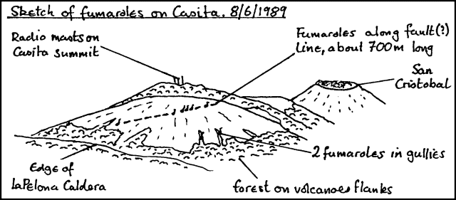 |
Figure 1. Oblique sketch of Casita, its fumaroles, and neighboring volcanic features, 8 June 1989. Courtesy of B. van Wyk de Vries and O. Castellón. |
Information Contacts: B. van Wyk de Vries and O. Castellón, INETER, Managua.
Strong gas plume from San Cristóbal; fumarolic activity at Casita
"The gas plume [from San Cristóbal] was continuously present and had not diminished since 1989. The plume could usually be traced up to 60 km from the volcano. Geologists visiting the crater [of Casita] reported fumarole temperatures of up to 98°C. Fumaroles in the S and E parts of the crater were H2O-rich and below 50°C."
Information Contacts: B. van Wyk de Vries, O. Castellón, A. Murales, and V. Tenorio, INETER.
Vigorous gas emission
A moderately large steam plume, with the same general appearance as in 1982, was observed many days during 23-29 April fieldwork at nearby Cerro Negro. Geologists were unable to measure the SO2 flux, but the plume was estimated to represent several hundred t/d.
Information Contacts: S.N. Williams, Arizona State Univ.
Gas plume; little evidence of acid rain
"San Cristóbal was producing a gas plume in January 1993 at levels comparable to recent years. On 6 and 7 January a plume extended over Chinandega (~15 km SW) at about 1,000 m above sea level. No gas was smelled at farms at the base of the volcano. There was patchy evidence of acid rain on the leaves of a few coffee bushes and other plant species, but effects were mild and the coffee crops were not reported to be affected. Analyses of rainwater collected for drinking purposes at one farm revealed cation and anion concentrations expected of normal rainwater, as did a sample from the spring of a neighboring farm. The analyses were undertaken by the British Geological Survey."
Information Contacts: Andrea Borgia, Instituto Nazionale di Geofisica, via di Vigna Murata 605, 00143 Roma, Italy; B. van Wyk de Vries, Open Univ; Peter J. Baxter, Dept of Community Medicine, Fenner's, Gresham Road, Cambridge, England.
Large steam plume
A large steam plume was observed at the volcano each day during the first week of September. The plume was clearly visible at distances tens of kilometers from the vent, and apparently filled the entire crater.
Information Contacts: Michael Conway and Andrew Macfarlane, Florida International Univ; Charles Connor, Southwest Research Institute; Oscar Leonel Urbina and Cristian Lugo, INETER.
Increased seismicity during March-July declines in August
The number of high-frequency seismic events increased from 46 in March to 897 in July. The number decreased again in August and September, but there were large tremors. For an unspecified time interval prior to 21 August the gas plume extended several kilometers from the volcano.
Information Contacts: H. Taleno, L. Urbina, C. Lugo, and O. Canales, INETER.
December vapor plumes appear smaller than previous ones
Since the end of the last rainy season, the vapor plume continuously present over the volcano has reduced in size compared to recent years. Late in 1996, fumaroles outside the crater decreased significantly. Fumaroles inside the crater concentrated in the lower part of the S and SE walls and had temperatures estimated to be in the 650-700°C range.
During the night and early morning on 24 December several incandescent areas were observed in the crater. These areas were similar to those reported over the past 15 years. Incandescence was visible from the top of the volcano at 500 m distance, and from the rim of the 1976 crater, a feature 400 m in diameter and 100-150 m deep. During 1996 small local earthquakes were detected monthly.
Information Contacts: Alain Creusot, Instituto Nicaraguense de Energía, Managua, Nicaragua.
Eruptions cause ashfall on the slopes; plumes to 2,500 m
According to press reports quoting an official from the Instituto Nicaraguense de Estudios Territoriales (INETER), an eruptive phase began at San Cristóbal during the night of 19-20 May. Because of the possibility of ashfall, authorities declared a state of alert in the city of Chinandega, one of the largest cities in Nicaragua, situated 20 km WSW, the main downwind direction. A report about precursory seismicity was provided by INETER on 18 May. Observations after the start of eruptive activity were sent by Benjamin van Wyk de Vries (Open University), and include information from INETER scientists.
Precursory activity as of 18 May. Strong seismic activity was detected starting in May, by far the strongest seismicity observed since the new seismic station (CRIN, ~3 km NW of the crater at the base of the volcano), was installed at the end of 1992. As of 18 May CRIN was recording 500 volcano-seismic events/day, with frequencies of 1-6 Hz and durations of ~1 minute or more. Sometimes roughly mono-frequency wavetrains of ~3 Hz were observed. RSAM values climbed from2 odor. INETER volcanologists visited the volcano on 17 May, but could not climb to the crater because of high gas concentrations.
On 18 May INETER was preparing an observation point at Casita volcano, ~4 km SE of San Cristóbal. At the seismic station, CRIN, additional channels with low amplification were switched to be transmitted to the Managua data center. The installation of additional seismic stations is planned. INETER volcanologists took gas and water samples for analysis, and local residents were being interviewed to obtain information about recent changes at the volcano. INETER informed the Nicaraguan Government and the Civil Defense Organization about the situation.
Activity during 21-26 May. B. van Wyk de Vries visited the volcano during 21-23 May, setting up the base for a deformation network, and checking the general state of the cone and crater. RSAM levels stayed fairly constant during this period, but began a slow decline at the end of May. Eruptions through 26 May produced light gray clouds of ash that normally rose 50-200 m above the crater. There were a few notable large eruptions, including one at about 0245 on 22 May that reached 800 m. The height differences were partly due to how quickly the plume was pulled over by the wind. One pulse made a noise that was heard 3 km away at the Casita observation post. Pedro Perez (contracted to The Open University), who was at the crater edge on the morning of the 22nd, noted dull noises before each ejection of ash. Sounds were not heard the next day, when the ejections were less powerful. There were periods of up to a few hours with very weak gas release, then equally long periods of eruptions every 5-10 minutes, or a constant plume. If the wind was strong the plume was dragged down the cone to ~900 m, after which it rose to 1,000-1,200 m; during calmer periods the plume rose to 2,500 m.
Summit visit on 23 May. There was no activity when the crater was reached at 1200 on 23 May. Volcanologists stayed for an hour installing a GPS station on the edge of the outer crater. They made a very quick descent into the crater and saw a new vent. Before the start of activity in early May, San Cristóbal was generally the same as when van Wyk de Vries first saw it in 1986. The main change has been the slow progressive growth of the inner pit crater (figure 2). There is an old outer crater ledge on the S side, then the main crater (10-50 m deep); a small inner cone has been gradually hollowed out by a pit crater. The cone has now mostly fallen in, and only a small part to the S and W still exists. The pit is ~80 m deep and Pedro Perez reported that in early May it had a flat bottom. At that time there was little degassing: a few fumaroles on the SW side and a few fumarole mounds on the SE part of the main crater floor. There had been a vigorous fumarole on the edge of the pit crater, with a temperature of ~600°C, but this part had fallen in. On 23 May there was a 4-m-wide vent in the SW part of the pit crater floor; looking in at 45° no bottom could be seen, and in shadow it was not glowing. On the walls of the pit were dark patches of wet rock, where water seepage or fumarolic emanations had discolored the new ash. The whole of the crater was covered by ash. On the crater floor it was 10 cm deep and around the edges 1-2 cm. The upwind crater rim (SE-N) had a slight dusting. On the downwind rim ash had been stripped off the top of rocks but was accumulating in fine layers on the vertical upwind surfaces. The ash was being continually blown around and formed some beautiful ripples.
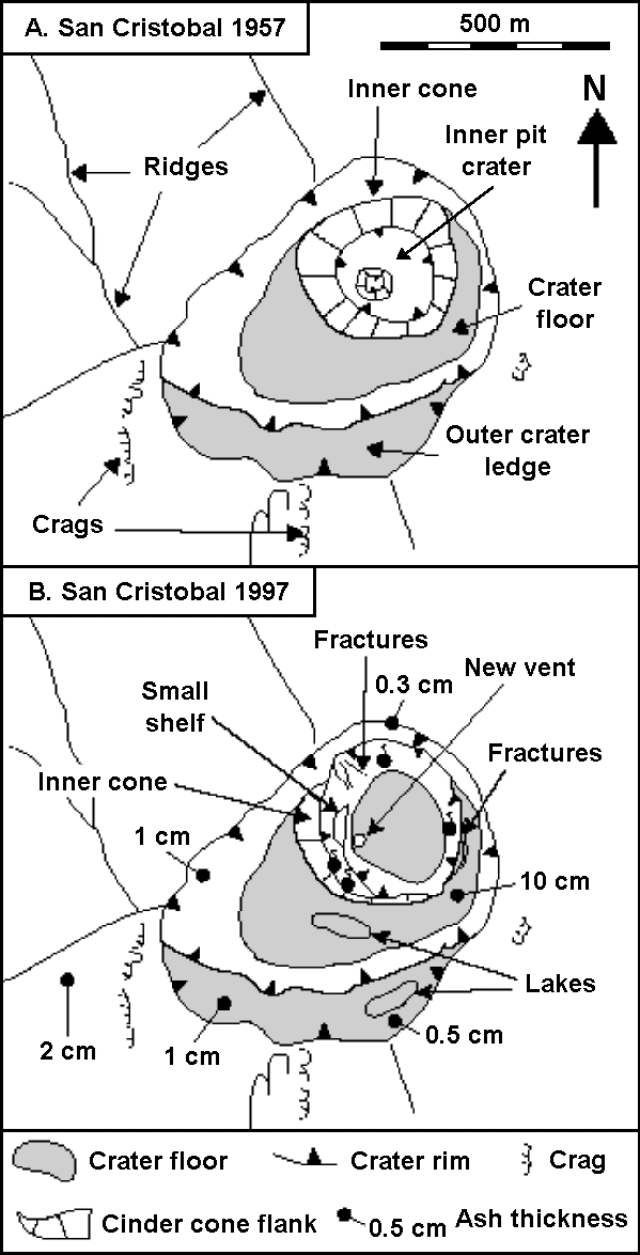 |
Figure 2. Summit maps showing crater features at San Cristóbal in 1957 and May 1997. The 1957 map is based on an aerial photo from the INETER collections. Courtesy of B. van Wyk de Vries, The Open University. |
Ash covered the W side of the mountain, giving it a light-gray appearance down to ~800 m. Although vegetation hid the ash layer from distant viewers, it continued down to ~600 m where a 1-3 mm thick layer coated the ground and dusted the leaves. Gas masks were worn during the descent from the summit because the ash billowed up. Down at the farm of Las Rojas (500 m elevation) there was a slight dusting of ash; other farms reported heavier falls. Vegetation damage was not observed, possibly because everything is so dry in the area. Very light ashfall was occurring 10-15 km downwind.
No tremor was felt at the crater, though there were ~600 events/day being recorded. Campesinos living on the pass between San Cristóbal and Casita felt shocks on the night of 21-22 May. The only significant deformation features noted on 23 May were several fissures around the edge of the inner pit crater, which indicate that it is still enlarging. The fractures on the main crater floor were covered in ash, which was not fractured, indicating that there was no movement over the previous few days. Pedro Perez noted some rockfalls during explosive activity on the morning of the 22nd, from the N side of the pit crater.
Deformation network.The new GPS network consists of two triangles. The outer triangle is centered on a point on the pass between Casita and San Cristóbal, with one position on Casita, one 2 km SE of Chinandega, and one 10 km NE of Chinandega. The lines are ~10 km long. The center point should form one corner of an inner triangle, the other points being at Las Rojas farm to the W and one as yet undecided on the N flank. These lines are <5 km long. Within the inner triangle, points were placed at ~1,500 m elevation on the SE flank and on the W side of the crater edge at ~1,700 m; both are 1-2 km from the center point. Simultaneous measurements at all four of the outer triangle points were taken with the Open University GPS and the INETER GPS. Two points on the volcano were fixed, and will be re-occupied by INETER personnel. Although the whole of the network is not in place, at least three points on the volcano have been fixed and will indicate any major movement.
Volcanic history. San Cristóbal is a stratovolcano 100 km NW of Managua that has erupted about nine times since the Spanish conquest. Its previous most recent confirmed eruption was a 45-minute ash emission in October 1977 (SEAN 02:10), but a small ash emission may have occurred in November 1987 (SEAN 13:01). The San Cristóbal complex comprises San Cristóbal cone, El Chonco cone, Cerro Montoso, Casita volcano, and La Pelona Caldera (Hazlet, 1987; Van Wyk de Vries and Borgia, 1996). San Cristóbal proper is the youngest feature of the complex. Casita was probably active in the 16th century, and has several active fumarole fields. La Pelona looks as though it was once a large stratocone that underwent a caldera-forming eruption in the Quaternary. El Chonco is an 800-m-high andesite-dacite cone. Cerro Montoso is a 600-m-high andesitic scoria cone cut by large faults.
The complex as a whole has a tendency to produce significant amounts of dacitic magma. Examples include the Chonco cone and Loma La Teta (a dacite dome associated with El Chonco), recent pyroclastic-flow and tephra deposits on San Cristóbal and Casita, and the La Pelona Caldera ignimbrite. This type of magma contrasts with the predominant basalt-basaltic andesite of the other nearby volcanoes, such as Telica, Rota, and El Hoyo/Cerro Negro. Martha Navarro (INETER), who has done geological and hazard mapping at San Cristóbal, noted that the dacitic pyroclastic-flow deposits of San Cristóbal are similar in composition to a thick tephra-fall deposit that the forms subsoil over much of the west side of the cone. On the cone itself, these deposits are covered by more recent andesitic scoriae and bombs, some or all of which come from the historical eruptions in the 17th century and the 1970's. There have not been any historical lava flows, but several lava flows are still only partially vegetated.
References. Hazlett, R.W., 1987, Geology of the San Cristóbal volcanic complex, Nicaragua, in Williams, S.N. and Carr, M.J. (eds.), Richard E. Stoiber 75th Birthday Volume: J. Volcanol. Geotherm. Res., v. 33, p. 223-230.
Van Wyk de Vries, B., and Borgia, A., 1996, The role of basement in volcano deformation, in McGuire, W.J., Jones, A.P., and Neuberg, J. (eds.), Volcano Instability on the Earth and Other Planets: Geological Society Special Publication 110, London, p. 95-110.
Information Contacts: Wilfried Strauch and Pedro Perez, Department of Geophysics, Instituto Nicaraguense de Estudios Territoriales (INETER), P.O. Box 1761, Managua, Nicaragua; Benjamin van Wyk de Vries, Department of Earth Sciences, The Open University, Milton Keynes MK7 6AA, United Kingdom; Reuters.
Seismicity, thin tephra falls, crop damage, and evacuation plans
Additional information has come to light regarding the eruption that began on the night of 19-20 May 1997 (BGVN 22:05). On the morning of 20 May, fine ash was found on cars in the town of Chinandega (18 km W of the volcano) and the same day people from Hacienda Las Rojas (~3 km SW of the crater) reported 1 mm of ashfall.
The 20 May explosions sometimes occurred nearly continuously for intervals of a few minutes, and at other times stopped for minutes or even hours. Yet, around that time the amount of ash expelled remained very low. The plumes typically moved to the SW, though on some occasions shifting winds carried them N or NE.
INETER volcanologists who visited Hacienda Las Rojas on 8 May prior to the eruption, noticed that the vegetation had been strongly affected by volcanic gases. As time passed, nearby people feared that continued eruptions would threaten local coffee plantations. Moreover, by an undisclosed date thirteen banana growers in Chinandega estimated damage at 40,000 boxes, a loss with an estimated value of US $160,000.
Small eruptions recurred, though in June the rainy season brought decreased visibility. As a result, both observation points at Casita volcano and San Cristóbal crater were frequently cloud-covered. Although during June ash only fell in small amounts and very near the volcano, starting on 3 July ash accumulated at a village 2 km W of the volcano (Las Rojas) and by an undisclosed time it reached 2-mm thickness. Also, starting on 7 July residents reported new ash in Chinandega, this time in greater amounts and composed of coarser particles than the May ash. The concern at INETER was that these coarser and thicker ashes could indicate the ascent of magma to shallower levels.
To prepare for outbursts of increased intensity the local administration together with the Civil Defense Organization took some preventive measures. Immediately after the 14 May alert information submitted by INETER, they organized meetings with local residents to explain evacuation plans. In Chinandega a meeting was organized that included high-ranking government officials and INETER volcanologists who explained the volcanic risk. Key roads in the populated area near the volcano were repaired to facilitate rapid evacuation if necessary.
Seismic data. The RSAM (Real-time Seismic Amplitude Measurement) index of seismicity was computed from the 10-minute mean of seismic amplitude at station CRIN (figure 3). This station, which lies near Hacienda Las Rojas (3 km SW of the crater) contains an L-4 seismometer and a 60-dB amplifier. The available time series contained occasional artifacts of telemetry or system interruptions. Some RSAM interruptions resulted from low batteries due to clouded skies and ash on solar panels. These artifacts were removed and then the data were filtered with an ~3-hour-long gliding mean that effectively removed the short time-interval maxima. Prior to this processing some maxima had reached 140 RSAM units.
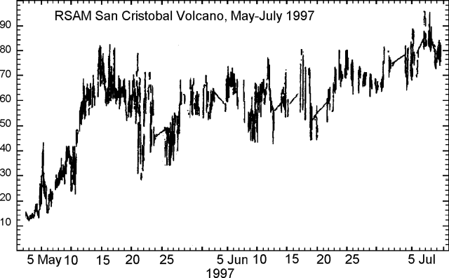 |
Figure 3. RSAM data from San Cristóbal, May-July 1997. Courtesy of Wilfried Strauch, INETER. |
The RSAM index reached a maximum on 14-15 May (figure 2) and remained stable until 23 May. It then declined to a minimum on 26 May. RSAM again reached ~60 at the beginning of June where it remained until early July, when it climbed to a maximum near 95 units.
Information Contacts: Wilfried Strauch, Department of Geophysics, and Marta Navarro C., Department of Volcanoes, Instituto Nicaragüense de Estudios Territoriales (INETER), P.O. Box 1761, Managua, Nicaragua.
Heavy rains from hurricane Mitch result in deadly avalanche and lahar from Casita
On 30 October 1998 a disastrous event (called a "mudflow" in newspapers) occurred on the S flank of Casita volcano. According to official reports, the incident killed between 1,560 and 1,680 people, displaced hundreds more, destroyed several towns and settlements, and disrupted the Pan American Highway at numerous bridges. On 11 and 12 November the first scientific team visited the volcano to investigate the disaster. The team examined the summit area on the first day and made a complete traverse of the devastated zone as far S as the Pan American Highway on the second day. This report presents the team's conclusions and provides some recommendations regarding future risks.
Background. Casita is within the Cordillera Maribios, a 70-km-long volcanic chain that extends from the N shore of Lake Managua to the vicinity of Chinandega. Casita is part of the San Cristóbal volcanic complex, which consists of five principal volcanic edifices. The largest volcano in Nicaragua, San Cristóbal lies 4 km WNW of Casita and has exhibited frequent episodes of historical activity; at present it is emitting a vigorous fumarolic plume. For these reasons San Cristóbal has been studied in greater detail.
Casita is a composite volcano with deeply dissected morphology. The top of the volcano consists of a cluster of dacite domes. At its summit is a 1-km diameter crater that could be reached by a road - now impassable - to service telecommunication towers. A set of prominent NE-trending normal faults cut the summit area bounding each side of the crater. Explosion craters on the southern plain are aligned along a conjugate set of fractures trending NW-SE. No historical volcanic activity has been reported at Casita; however, the domes of the summit area are autobrecciated and exhibit strong hydrothermal alteration, which is consistent with low-temperature fumarolic activity.
Meteorological conditions. Hurricane Mitch was a major factor in the disaster. Abnormal rainfall related to Mitch began on 25 October. By 27 October the precipitation reached 100 mm/day and increased continuously to a maximum of ~500 mm/day on 30 October, the day of the avalanche. The total rainfall in October was 1,984 mm. Within three days, precipitation dropped to normal levels. For comparison, the average rainfall for October is 328 mm; thus the rainfall associated with the disaster was more than 6 times the average.
Source zone. The main source of the avalanche was 200 m SW of the volcano summit, and 60 to 80 m below the telecommunication towers. A secondary source was located at the same elevation but 100 m SE of the summit. The rock in this area is a hydrothermally altered and brecciated dacite dome. The principal rupture occurred along a ~500-m-long segment of a NE-trending fault that intersects the summit. A slab measuring ~20 m thick, 60 m high, and 150 m long detached slid down the fault plane that was inclined about 45 degrees SE. The volume of source block for the first rockslide was ~200,000 m3.
Avalanche event. Inhabitants of the lower plains described the sound of the avalanche as similar to a helicopter. Multiple witnesses gave the time as between 1030 and 1100 on 30 October. The main slide mass immediately shattered into its original breccia blocks coated by vein precipitates. The initial SE movement of the avalanche blocks was deflected to the SW along a deep gully oriented parallel to the fault. A smaller part of the avalanche surmounted a small ridge and continued SE towards the village of Argelia.
For the first 2 km the main avalanche remained confined to a narrow valley. The top of the flow was 150 to 250 m wide; its depth, 30 to 60 m. A typical cross section of the peak flow was 7,500 to 9,000 m2. The flow swashed back and forth on its downward course. Super-elevation calculations at locations of overbank flow gave a velocity of ~15 m/s in the upper reaches. Deposits high on the volcano consisted of altered dacite blocks up to meter-size. They contained essentially no matrix, with the finest particles centimeter-sized. The margin of the avalanche was sharp and flying rocks scarred the adjacent trees at 2-3 m height. A few trees were decapitated at heights of several meters.
At a prominent break in slope 2-3 km from the source, large ramps of avalanche materials formed imbricate ridges. Here the deposits, 4-6 m thick, still lacked matrix. The avalanche materials were essentially clast supported. The avalanche scoured blocks of lava from the walls, and up to 10 m deep into clay-rich soil in the base of the valley where it passed.
Lahar runout flow. Soon after the onset of the avalanche, a lahar runout flow, as defined in Scott (1988), initiated from the major accumulation zone of the primary avalanche. In other words, the source of the lahar runout flow formed in the thickest accumulation of debris at the mouth of the avalanche valley, 3 km from the summit and 3 km above the towns of El Porvenir (formerly Augusto Cesar Sandino) and Rolando Rodriguez. The populations of these two towns were respectively 600 and 1,250 according to the last census. The location of the sites of El Porvenir and Rolando Rodriguez could only be found by GPS data; there remained almost no evidence of former human habitation.
Apparently the lahar runout flow resulted from rapid dewatering of the saturated avalanche. The flood surge moved as a hyperconcentrated flow, depositing a thin (~40 cm thick) layer of gravel with some clay matrix on the overbank zones, and transporting meter-size blocks within the incised channels. The peak height of the flood surge was 3 m as it entered El Porvenir, as evidenced by stripped bark from the few standing trees. Nearly all vegetation and soil was removed by the leading edge of the wave. However, a few islands of vegetation were spared on some hills. The width of the flood surge in its upper reaches was ~1,500 m. Assuming an average peak depth of about 3 m, this yields a cross sectional area of flood surge at 4,500 m2.
Casualties and damage. Based on observations in the field, the towns of El Porvenir and Rolando Rodriguez were destroyed beyond recognition. It is unknow how many people survived. Visible cadavers and dead livestock on the overbank had been burned for sanitary reasons. Many other small hamlets, residences, and farms were destroyed.
Future hazard potential. The disaster of 30 October, was produced by the coincidence of two discrete events: extraordinarily heavy rains and an avalanche. Neither of these alone would have produced such extensive damage to the surrounding area. In this respect note that the towns of El Porvenir and Rolando Rodriguez were established only a few decades ago in this area of high geologic risk. To reduce threats for new settlements, comprehensive geologic hazard studies can help identify regions with elevated risk.
In the absence of another episode of heavy rainfall, the new deposits seem to be stable. In fact, there is little mud or silt within the deposits at higher elevations to facilitate remobilization. However, the conditions near the summit that favored the rockslide avalanche still exist. Altered and fractured dacite occurs on steep slopes at a high elevation. Destabilizing events, such as an earthquake or torrential rains, could produce another avalanche in an adjacent area. The probability of such an extreme avalanche seems remote. However, an assessment of the associated hazards and risks should be undertaken.
Reference. Scott, Kevin M., 1988, Origins, behavior, and sedimentology of lahars and lahar-runout flows in the Toutle-Cowlitz River system: U.S.G.S. Professional Paper 1447-A, 74 p.
Information Contacts: Michael F. Sheridan, SUNY, Buffalo, New York; Claus Siebe, UNAM, Mexico; Christophe Bonnard, EPFL Lausanne, Switzerland; Wilfried Strauch; Martha Navarro, Jorge Cruz Calero, and Nelson Buitrago Trujillo, INETER, Nicaragua.
Continued frequent eruptions and ashfall through December 1999
A new eruption began at about 2200 on 20 November 1999 (figure 4) with a series of explosions that caused ashfall near the volcano. More than 100 people were evacuated from the Hacienda Las Rojas. A commercial airline pilot reported that the ash plume reached about 2.4-3 km altitude. As of the start of this increased activity, the Nicaraguan Institute of Territorial Studies (INETER) reported that volcanic tremor and sporadic minor ash emissions had occurred for more than a year.
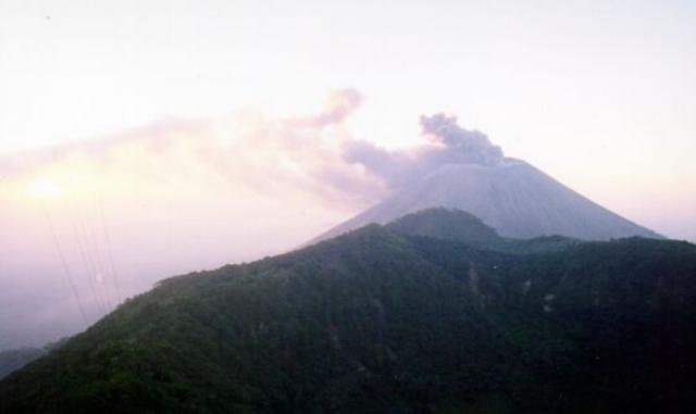 |
Figure 4. Photograph showing ash emissions from San Cristóbal on the afternoon of 21 November 1999. The view is from the top of Casita volcano, 4 km away. The dark part in the foreground is the edge of the Casita crater. Courtesy of Wilfried Strauch, INETER. |
The last previous significant eruptive activity at San Cristóbal began on the night of 19-20 May 1997 and spread fine ash on Chinandega, 18 km W (BGVN 22:05 and 22:06). On 30 October 1998 earth movements on the S flank of Casita volcano (4 km ESE of San Cristóbal) resulted from heavy hurricane rains, killing an estimated 1,560-1,680 people, with hundreds more displaced and several towns and settlements destroyed (BGVN 23:10). The following is based on INETER reports from November through the end of February 2000, with additional information based on crater visits in January and February and satellite imagery of a large eruption plume on 21 February.
Seismic tremor increased during the night of 19-20 November and quickly reached a maximum that was not matched at least through the end of December (figure 5). Tremor amplitude declined throughout 20 November, and then remained at levels of ~25-60% of the 20 November peak until a volcano-tectonic earthquake on 27 November.
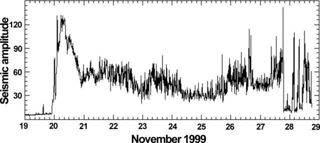 |
Figure 5. RSAM (real-time seismic amplitude measurement) data showing the relative amplitude of seismic tremor at San Cristóbal recorded at the seismic station near the Hacienda Las Rojas, at the foot of the volcano, 19-28 November 1999. Seismicity began during the night of 19-20 November, although volcanic activity at the surface was not reported until the following night of 20-21 November. Ashfall was reported at dawn on the 21st near the volcano. The high peak at 1520 on 27 November was caused by a volcano-tectonic earthquake. Courtesy of INETER. |
Small explosions preceded emissions on 22 November. Activity decreased after the initial eruptions, but a lack of winds caused the ash and gases to remain near the volcano. Concentrations of CO2 and SO2 measured on 22 November at three different sites exceeded the permissible limits established by the World Health Organization (WHO). INETER inspections showed that expelled gas and ash have been accumulating in local communities. However, on 23 November a slight increase in the wind speed facilitated the transport of volcanic material as far as the city of Chinandega 10 km to the SW. That day an observation post was established near the summit of Casita, where INETER staff could make visual observations and measurements of eruption column heights.
Ash emanations during 24-27 November varied in frequency, and the observer at Casita saw ash columns to heights of 100-300 m above the crater during the same period. At 0920 on 27 November a small earthquake (M 2.3) occurred ~2 km underneath the volcano. Volcanic gas monitoring on 24 November showed a significant increase in the concentrations of SO2 in the San Rafael and Las Rojas areas. However, the concentration of CO2 showed a diminution compared to 23 November. Concentrations of SO2 and CO2 decreased again on the 25th, although in some communities the level of SO2 remained unchanged. A correlation spectrometer (COSPEC) for measuring SO2 flux was brought from the INSIVUMEH of Guatemala on 26 November, with the support of the Coordination Center for the Prevention of Natural Disasters in Central America (CEPREDENAC).
Seismic tremor amplitude remained fairly stable, around 30-50% of the 20 November peak, during 26 November through 13 December. Seismicity fluctuated, with periods of higher and lower amplitude; a corresponding fluctuation in the ash-and-gas emissions was noted. The amounts of gases emitted by the volcano also showed this correlation, with SO2-flux values that oscillated between 100 and 1,000 tons/day.
By 2 December ash emissions had decreased considerably, although low-level gas emissions remained continuous. There was a slight increase in emissions on 4 December, but activity remained low through the 13th. Higher wind speeds during this period helped keep gas concentrations low in local towns. Seismic tremor began to rise the night of 12-13 December to a high of 70% of the previous peak. On 14 December small amounts of volcanic ash fell in Chinandega. Tremor amplitude returned to ~40% of the peak on 15 December, then decreased to 20-30% of the peak by dawn on the 16th.
Lahars on 16 December 1999. The Civil defense and local residents reported that a mass-flow on the NW side of the volcano on 16 December stopped ~2 km from populated areas. On 21 December, two specialists visited the affected Rancherías region NW of San Cristóbal in the Municipality of Chinandega (Dpto. Chinandega) to investigate the event. According to the meteorological station of Chinandega, 7.9 mm of rain fell from 1824 until 2012; in the first hour strong rains were reported, and from 1920 there were light to moderate rains. Previous strong rains have produced erosion gullies on the slopes of the volcano.
Due to the recent eruptive activity, large amounts of ash and lapilli had accumulated in these gullies; these were mobilized by the rains into lahars. Several sources were identified between 1,400 and 1,500 m elevation. The mobilized material formed a debris flow containing ash and lapilli that carried blocks varying from centimeters to meters in size. The flow quickly cemented into an extremely hard deposit. The material eroded from the highest slopes of San Cristóbal moved along one main gully, leaving a very deep channel and, below 500 m elevation, an extended lobate deposit that reached within ~2 km of the community of Ranchería. The main flow had a length of ~7 km and variable widths between 10 and 150 m; deposit thickness varied from less than 10 cm up to 2 m at the terminus.
Similar events happened on the S slope of the volcano that same day. At least five lahars were visible from the Leon-Chinandega highway.
Minor ash emissions continue. Activity remained consistently low and unchanged until noon on 28 December when earthquakes began. These were centered SE of Casita with magnitudes between 2 and 3.5 and depths of a few kilometers. The occurrence of earthquakes near San Cristóbal is a new phenomenon in the current eruption. Ash emission also increased and small amounts fell in Chinandega.
Seismic tremor on 29 December increased to as high as 40% of the 20 November peak. Small amounts of ash fell in Chinandega and El Viejo. No significant changes in activity were noted on 30 December. Moderate ashfalls were reported near the volcano and in Chinandega. Depending on the wind direction, ashfall sporadically reached the communities of Higueral, 10.5 km NE, and Pelona, 9 km E.
Activity during January-February 2000. Small explosions continued during January with ash and gas emissions (figure 6) and 4,444 registered volcanic earthquakes. Seismicity was higher in the first 17 days of January, but the seismic tremor (RSAM) stayed constant. Between 17 and 23 February activity increased, causing significant ashfall in Chinandega. The number of registered volcanic earthquakes in February was of 1,784.
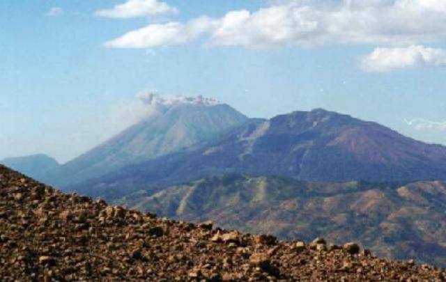 |
Figure 6. Ash emissions from San Cristóbal on 13 January 2000. The view is from the summit of Telica volcano. Courtesy of INETER. |
Alain Creusot visited the crater on 10 January and observed rhythmic, phreatic explosions, which included rock ejections and ash columns from three vents. At 0600 that day, a violent explosion threw bombs high above the crater rim. Creusot visited the crater again on 4 February and observed a 50-cm-deep ash layer over the crater area and 30-cm depths over the entire summit. Rhythmic phreatic explosions continued and new bombs were observed and sampled on the E crater rim (figure 7). These bombs apparently originated from a Strombolian explosion on 30 January. A third visit on 20 February showed a 1-m-deep ash layer in the crater area and 50-cm depths elsewhere in the summit area. Rocks 50 cm in size had been ejected.
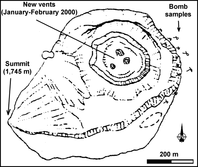 |
Figure 7. Sketch map of the San Cristóbal summit area showing the new vents within the crater and locations of bombs deposited following an explosion on 30 January 2000. Courtesy of Alain Creusot. |
Benjamin van Wyk de Vries noted that GOES images on 21 February showed a long plume extending from San Cristóbal to ~100 km over the Pacific Ocean. He also reported that this was the strongest ash eruption at San Cristóbal since the 1997 eruption. At 1100 on 24 February, a violent explosion threw bombs over the entire summit. A similar explosion and effects occurred at 0900 on the 25th.
Information Contacts: Wilfried Strauch and Virginia Tenorio, Dirección General de Geofísica, Instituto Nicaragüense de Estudios Territoriales (INETER), Apartado 1761, Managua, Nicaragua (URL: http://www.ineter.gob.ni/); Alain Creusot, Instituto Nicaraguense de Energía, Managua, Nicaragua (URL: http://www.ine.gob.ni/); Benjamin van Wyk de Vries, Departement des Sciences de la Terre, Universite Blaise Pascal, 63038 Clermont-Ferrand, France.
Emissions decreased in March; several lahars occurred in May
In May 2000 a series of lahars at San Cristóbal mobilized ash that had been deposited on the volcano from the 20 November 1999 eruption (BGVN 25:02) and from sporadic ash-and-gas emissions during November to May.
In March 2000 the number of ash-and-gas emissions decreased from levels in February. The number of seismic events also substantially decreased from 1,748 in February to 181 in March, but seismic tremor remained high. Two noteworthy seismic events occurred on 15 March at 1200 and 1311. One was felt by settlers who live on the volcano's flanks and by observers on Casita's summit.
INETER personnel noted that ash emissions from the volcano's secondary crater continued in March. They observed a large number of fumaroles that surrounded the internal wall of the secondary crater. The fumaroles were determined to have a maximum temperature of 120 °C using a hand-held infrared sensing instrument. On 19 and 20 March Pierre Delmelle (Université de Montréal) and Julio Alvarez (INETER - GEOFISICA) performed COSPEC measurements near the volcano that yielded SO2 fluxes of 352-1,644 tons/day, with an average value of 873 tons/day. Activity during April was similar to March with sporadic gas-and-ash emissions.
Just after the beginning of the rainy season on 13 May, lahars traveled down the flanks of the volcano to the N, NW, and S. INETER seismologists detected the lahars in progress using two seismic stations located S and SW of the volcano. The lahars were small, traveled long distances, and were not considered dangerous because they traveled within channels and caused no destruction to populated areas. The deposited material consisted partly of volcanic ash that had accumulated since the ongoing eruption began in November 1999. The average thickness of the deposited material was 30 cm and the total volume was 275,000 m3.
After strong local rains on 17 May, lahars similar to the 13 May lahars traveled down the slopes of San Cristóbal to the NW and SW. The thickness of the deposited material was 30-35 cm, and the volume was between 25,000 and 200,000 m3. In addition, on 19 May lahars traveled to the N, SW, and S.
On 30 April Alain Creusot observed the new crater for 4 hours from the NE crater rim (figure 8). He noted that 2 to 4 million m3 of ash was deposited at the summit area. He also found the crater was 200 m deep, which was 50 m deeper than when it was observed in January. In addition, a new vent had opened in the crater to the NE. The change in the crater's depth indicated that 4 to 5 million m3 of lithic ash had been ejected. Rhythmic phreatic explosions reached an altitude of 500-600 m and a permanent jet-like noise was heard from steam-and-gas emissions. Rock fall activity was concentrated to the SE of the old crater.
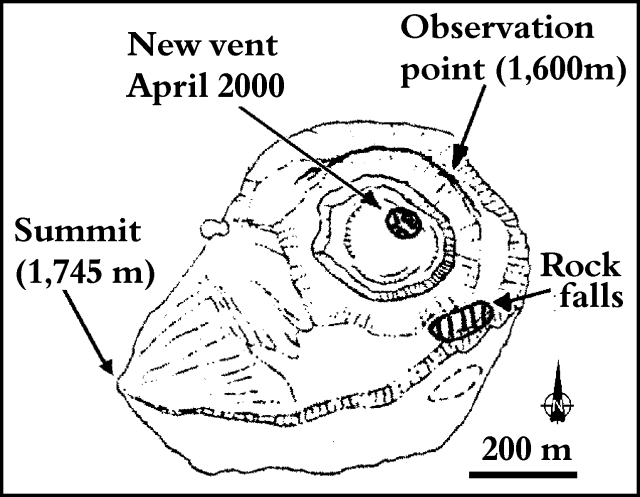 |
Figure 8. Sketch map of the San Cristóbal summit area showing the new vent within the crater and the location of recent rock falls. Courtesy of Alain Creusot. |
During a visit on 22 June he found the 2-4 million m3 ash deposit at the summit had been washed mainly down the volcano's SW slope by rain. The new crater had been refilled to an approximate depth of 150 m. Fumaroles in the old part of the crater were measured to be 200-250 °C, and 500-600 °C in the crater's deep part. Steam-and-gas emissions continued to produce a loud noise.
Information Contacts: Wilfried Strauch and Virginia Tenorio, Department of Geophysics, Instituto Nicaragüense de Estudios Territoriales (INETER), P.O. Box 1761, Managua, Nicaragua (URL: http://www.ineter.gob.ni/); Alain Creusot, Instituto Nicaraguense de Energía, Managua, Nicaragua (URL: http://www.ine.gob.ni/).
Small gas-and-ash plumes during May and June 2001 cause ashfalls
Beginning on 11 May 2001 volcanic activity increased above normal levels, with small eruptions producing gas-and-ash clouds that deposited small amounts of ash on a neighboring town. The previous report of anomalous volcanic activity at San Cristóbal was in May 2000 when a series of lahars occurred as a result of the remobilization of ash that had been deposited on the volcano from the 20 November eruption (BGVN 25:02 and 25:05).
On 22 July 2000, ten months prior to the May 2001 eruption, Alain Creusot visited the summit of the volcano. He reported that seismic activity during 18-19 July caused two lakes to empty that were observed during a previous trip. He also found that active fissures inside the crater were partially sealed, which caused the intensity of degassing to decrease.
INETER reported that on 11 May 2001 tremor began to rise at a seismic station on San Cristóbal (figure 9). The tremor reached a maximum level at noon and then slightly diminished, but stayed at relatively high levels for several days. Seismic activity during this period exceeded the maximum level of seismicity throughout the entire December 1999-February 2000 eruption (BGVN 25:02). Beginning on 11 May INETER personnel stationed near the summit of the volcano occasionally observed small plumes of volcanic gas with small amounts of ash emanating from the volcano. In contrast, on 10 May very low levels of gas were emitted from the crater. On 14 May observers noted that gas emissions with small amounts of ash continued. On 17 May the level of seismic activity significantly increased, and pulses of gas and ash rose ~100 m above the crater rim. Small amounts of ash fell in the town of Santa Barbara, 14 km SW of the volcano.
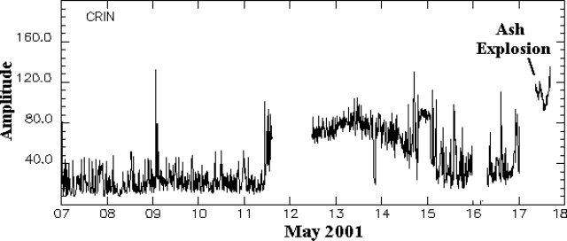 |
Figure 9. Seismic amplitude recorded at CRIN seismic station on San Cristóbal during 7-17 May 2001. Courtesy of INETER. |
INETER noted that rain could mix with ash deposited on the flanks of the volcano and generate dangerous lahars. This occurred after the 1999-early 2000 eruption when rainfall in May 2000 mixed with ash that accumulated on the flanks of the volcano. The lahars were especially strong in the S part of the volcano.
According to news reports, on 21 June an explosion at San Cristóbal sent an ash cloud to a maximum height of 800 m. The cloud extended approximately 25 km downwind of the crater, and ash fell in the town of Chinandega, ~15 km SW of the volcano.
Information Contacts: Wilfried Strauch and Virginia Tenorio, Department of Geophysics, Instituto Nicaragüense de Estudios Territoriales (INETER), P.O. Box 1761, Managua, Nicaragua (URL: http://www.ineter.gob.ni/); Alain Creusot, Instituto Nicaraguense de Energía, Managua, Nicaragua (URL: http://www.ine.gob.ni/); La Noticia (URL: http://www.lanoticia.com.ni/); El Nuevo Diario (URL: http://www.elnuevodiario.com.ni/); La Prensa (URL: http://www.laprensa.com.ni/).
Minor ash eruptions during May-November 2001; elevated seismicity
Ash fell at San Cristóbal during May and June 2000. Relative calm prevailed after then until May 2001, when activity began to increase. Thousands of earthquakes per month occurred during June through at least October 2001. Explosive eruptions in mid-August produced columns that reached 400 m.
Seismic signals registered on 2, 4, and 7 May 2001 indicated that small explosions had probably occurred. At 0900 on 11 May, seismic tremor increased to a level exceeding that observed during the eruption in December 1999 and the early months of 2000 (BGVN 25:02). The volcano emitted ash and gas beginning on 12 May. A total of 2,748 seismic events were registered during the month. No dominant frequency was observed during the beginning of the month, but during the rest of the month dominant frequencies of up to 6.7 Hz were noted. Pulses of gas-and-ash emissions were seen rising up to 100 m above the crater rim, and light ash fell in the town of Santa Barbara, 14 km SW of the volcano. The volcano was relatively calm at the end of May.
During June there were three periods of increased seismicity, rapid degassing, and release of gas and ash. The total of 2,276 earthquakes during the month were mostly associated with degassing. On 7 June at 0240, seismic tremor increased, and minutes later dark clouds were observed. At 0500, gray ashfall was reported 10 km SW of the volcano. Activity decreased beginning 9 June until 16 June, when high-energy seismic activity and ash emissions increased for about five hours. The dominant frequency of the 16 June earthquakes ranged between 10 and 12 Hz. On 20 June at 1048 tremor increased again and ashfall began one hour later. A vibration was felt, and noise was heard as far as 6 km from the volcano. The activity ceased five hours later.
According to news reports, on 21 June an explosion sent an ash cloud to a height of 800 m that extended ~25 km downwind and caused ashfall in the town of Chinandega, ~15 km SW. The same day, Jorge Cruz of Indiana Carcache and Martha Navarro of INETER visited the volcano and observed abundant gas-and-ash emissions. Gas sampled on 22 June contained 2.6 mg/m3 of SO2 and 250 ppm CO2. The low concentrations suggest weakened gas pressure and no new magmatic material.
During July 2001, San Cristóbal displayed reduced seismic tremor, but the number of volcanic earthquakes was high. More than 6,111 seismic events were registered, including long-period (LP) earthquakes and signals of small gas explosions. LP earthquakes are common at active volcanoes, and have been observed at other Nicaraguan volcanoes just before eruptions. This was the first time this type of signal had been observed at San Cristóbal, so it was not clear if they had occurred prior to or during past explosions. According to Chouet (1996), LP earthquakes are generated by resonance in fractures closed at their ends and filled with volcanic fluids (water or magma) with a certain dissolved gas level, in which an abrupt pressure change takes place. On 22 July at 0134, an LP earthquake was registered that lasted ~17 seconds with a dominant frequency of 1.2 Hz. Three seismic stations recorded the earthquakes, the most distant located ~15 km W of the volcano. In addition to these seismic data, Vicente Perez ascended the volcano during July and heard both landslides moving down the crater's walls and several rumblings.
During August 2001 tremor remained low to moderate and 4,552 earthquakes were registered. The number of earthquakes was high (averaging ~300 events per day) during 1-4 August, but began dropping gradually on 5 August. The dominant frequency of LP events was ~1 Hz. On 8 August tremor began to increase but the number of earthquakes decreased compared to the previous days. On 10 August, 9 seismic events were registered and tremor increased. On 11 August tremor stood at 30-40 RSAM units. Most of the earthquakes had dominant frequencies of 1-7 Hz. On 12 August, tremor increased again until it reached 80 RSAM units. The increase in tremor lasted until the evening of 13 August when it lowered to 30 RSAM units. During 14-15 August tremor increased again, reaching 90 RSAM units. On 14 August incandescence was visible in the crater for the first time during the current episode. INETER stated that gas and clouds above the summit crater were illuminated from below.
On 15 August beginning at 1620 a dense cloud was formed from continuous abundant out-gassing. Rumbling, incandescence, and explosions were observed during 15-17 August. On 16 August, Vicente Perez ascended the volcano to make observations and found an increase in fumarole temperatures. During 0900 through 1030, gas explosions occurred with columns that reached 400 m. Seismic tremor gradually decreased until approximately 1400 on 17 August when strong seismic activity began again. Fumarolic activity increased and small lagoons within the crater had dried. On 18 August tremor lowered to normal levels of 20 units RSAM. The absence of earthquakes and LP events was noted during this time. The dominant frequency of most of the tremor was 1.0-6.0 Hz. Ash explosions were observed until the afternoon of 19 August.
Based on the recent activity at San Cristóbal, INETER believes that magma rose slowly in the volcano's open conduit and remained close to the crater's floor, which allowed the incandescence observed at night. This was consistent with the observed increase in fumarole temperatures.
During September, seismic activity continued, along with degassing and noise in the interior of the crater. A total of 4,695 earthquakes were registered during the month. After the eruptive activity that occurred during August, San Cristóbal maintained a low level of tremor (less than 20 RSAM units). Tremor increased on 7 September, accompanied by earthquakes with dominant frequencies of 2-6 Hz that occurred every minute for 24 hours. Few LP events were registered. On 8 September, Perez again ascended the volcano and found a slight increase in the temperatures of most of the fumaroles. Abundant degassing took place during the month and noises were heard in the interior of the crater. During 17-19 September tremor increased again, and was accompanied by earthquakes that occurred in bands of time that lasted, on average, one hour. During the last week of September, another increase in tremor took place, as well as an increase in the number of earthquakes. On this occasion, tremor lasted several days and was accompanied by earthquakes approximately every hour.
During October 2001, seismic tremor remained at 20-40 RSAM units. The dominant frequency of tremor was 4-6 Hz. A total of 7,421 earthquakes were registered during the month. Most of the earthquakes had dominant frequencies of from 5 to over 10 Hz. Few events registered dominant frequencies less than 1 Hz. Despite the increase in earthquakes since June 2001, little eruptive activity has taken place (small ash explosions and gas emanations). During the month San Cristóbal displayed emanations of gas, ash, and noise in the interior of the crater. On the night of 3 October, Perez reported ashfall on surrounding communities. On 7 October, Perez ascended the volcano and reported that a collapse had occurred in the S part of the crater.
INETER reported that during the evening of 12 November small ash emissions at San Cristóbal produced ash clouds that remained around summit level. According to the Washington VAAC, on 12 November at 1645 GOES-8 imagery showed a small area of possible ash drifting NW. Ground observers noted moderate volcanic activity until 1800. Ash had dissipated by 2100 and the next day there were no ground reports of volcanic activity.
General Reference. Chouet, B.A., 1996, Volcano long-period seismicity: its source and uses in eruption forecasting: Nature v. 380, p. 309-316.
Information Contacts: Virginia Tenorio, Department of Geophysics, Instituto Nicaragüense de Estudios Territoriales (INETER), P.O. Box 1761, Managua, Nicaragua (URL: http://www.ineter.gob.ni/); La Noticia (URL: http://www.lanoticia.com.ni/); El Nuevo Diario (URL: http://www.elnuevodiario.com.ni/); La Prensa (URL: http://www.laprensa.com.ni/); Washington Volcanic Ash Advisory Center (VAAC), Satellite Analysis Branch, NOAA/NESDIS/E/SP23, NOAA Science Center Room 401, Camp Springs, MD 20746, USA (URL: http://www.ssd.noaa.gov/).
November ash-and-gas emissions; thousands of earthquakes through May 2002
Instituto Nicaragüense de Estudios Territoriales (INETER) reported that during December 2001 through May 2002 San Cristóbal maintained generally constant levels of seismicity and moderate tremor levels. Thousands of earthquakes per month were recorded, most with frequencies of 4.0 to over 10 Hz. Very few events registered with frequencies less than 1.0 Hz.
The third eruptive stage in 2001 was during 7-25 November, when strong ash-and-gas emissions and rumblings occurred and small amounts of ash fell in surrounding areas. After visiting the crater on 11 and 25 November, and 9 December, Vicente Perez (INETER) reported rockfalls and strong emissions of gas and ash. Fumarolic temperatures on 25 November were ~40-100°C, and were similar during December. On 15 January Pedro Perez observed only sporadic gas emanations during a crater visit.
During November through 23 February seismic tremor generally remained between 20 and 60 RSAM units, with the maximum tremor occurring during 8-14 November, when ash-and-gas emissions were strongest. Tremor frequency was 4.0-6.0 Hz.
Observations on 6 February revealed an overall lack of visible changes at the volcano with the exception of gas emanations in the new crater. On 24 February seismic tremor began to increase until it reached 40 RSAM units. While the tremor increased, the number of earthquakes diminished. Strong rumblings on 22 and 26 February, coinciding with the increase of tremor on 24 February, were accompanied by gas emissions.
Another increase in tremor began on the afternoon of 6 March. Strong seismicity occurred in 2- to 3-hour periods that were generally separated by less than 1 hour of less intense activity. INETER reported that seismic tremor reached more than 50 RSAM units on 7 March. Scientists visiting the volcano found that the amount and temperature of degassing had increased. Reportedly, incandescent material in the crater was reflected on the clouds above it. On 22 March at 2219 an earthquake was felt by most of the population near the volcano. Following this event, more than twelve earthquakes with magnitudes of 2.0-3.2 occurred. According to INETER, associated activity was not strong enough to warrant raising the Alert Level.
During April an average of 30 earthquakes occurred per hour (figure 10), most associated with degassing. Very few events were volcano-tectonic or explosion earthquakes. Seismic tremor remained between 40 and 45 RSAM units.
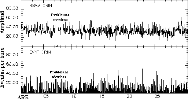 |
Figure 10. Seismic amplitude RSAM (top) and number of earthquakes per hour (bottom) at San Cristóbal during April 2002. Courtesy INETER. |
On 23 May a strong gas column was observed at San Cristóbal. The Washington Volcanic Ash Advisory Center (VAAC) stated that a surface report had indicated strong activity near the summit. A plume was visible on satellite imagery drifting SW from the summit (figure 11). A video camera near the summit indicated that the altitude of the plume was relatively low, near ~3 km. The Washingon VAAC issued a second notice stating that according to INETER, the emissions consisted solely of gas. The VAAC noted that no plume was detected in satellite imagery later that day. INETER reported that the column was the result of rain in the crater that generated steam. No other phenomena were observed that could indicate an increase in the eruptive activity of the volcano.
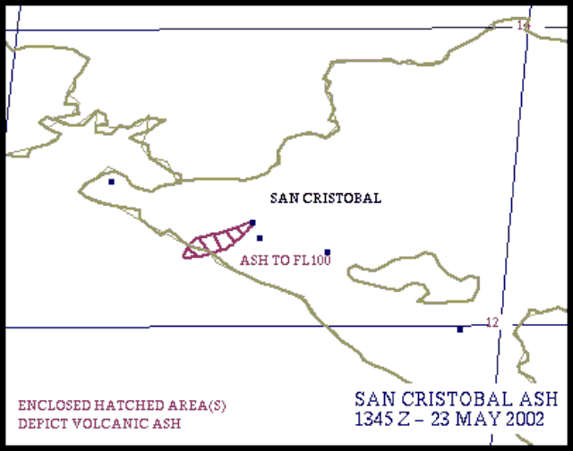 |
Figure 11. Sketch based on satellite imagery depicting a plume drifting SW from San Cristóbal on 23 May 2002. Courtesy NOAA. |
Information Contacts: Virginia Tenorio, Department of Geophysics, Instituto Nicaragüense de Estudios Territoriales (INETER), P.O. Box 1761, Managua, Nicaragua (URL: http://www.ineter.gob.ni/); La Noticia (URL: http://www.lanoticia.com.ni/); El Nuevo Diario (URL: http://www.elnuevodiario.com.ni/); La Prensa (URL: http://www.laprensa.com.ni/); Washington Volcanic Ash Advisory Center (VAAC), Satellite Analysis Branch, NOAA/NESDIS/E/SP23, NOAA Science Center Room 401, Camp Springs, MD 20746, USA (URL: http://www.ssd.noaa.gov/).
Tremor increases during late May 2002, activity continues in August
Activity at San Cristóbal during November 2001-May 2002 included strong [gas] emissions on 23 May (BGVN 27:04). At the time, no other phenomena were observed that could indicate an increase in the eruptive activity of the volcano. Volcanic tremor began to increase at San Cristóbal on 28 May, reaching a peak of ~150 RSAM units around noon the next day (figure 12). The summit of the volcano was not visible, but satellite imagery from the Centro de Vigilancia de Ceniza Volcánica revealed that ash was emitted from the volcano. After the 29th, the amount of tremor began to decrease. Incandescence was visible at the crater rim on 1 June. By 3 June tremor was still relatively high.
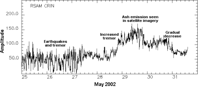 |
Figure 12. Seismicity at San Cristóbal as measured by RSAM (y-axis, arbitrary RSAM units) during 25-31 May 2002. Courtesy INETER. |
A ground observer in Chinandega, Nicaragua indicated that San Cristóbal was active on 21 August around 1600. Ash was not visible on an INETER volcano camera at 1630 due to dense cloud cover. A possible plume was detected on satellite imagery taken at 1545 during a break in the cloud cover; it was estimated to be near summit level and drifting W. The volcano remained at Alert Level Orange.
Information Contacts: Wilfried Strauch, Director General de Geofísica, Instituto Nicaragúüense de Estudios Territoriales (INETER), P.O. Box 1761, Managua, Nicaragua (URL: http://www.ineter.gob.ni/); Washington Volcanic Ash Advisory Center (VAAC), Satellite Analysis Branch, NOAA/NESDIS/E/SP23, NOAA Science Center Room 401, Camp Springs, MD 20746, USA (URL: http://www.ssd.noaa.gov/); La Prensa (URL: http://www.laprensa.com.ni/).
Intermittent ash emissions between August 2002 and September 2003
This report summarizes the recorded activity at San Cristóbal during August 2002-September 2003. Reports from Instituto Nicaragüense de Estudios Territoriales (INETER) include observations from frequent visits to the volcano.
August-December 2002. During August-December 2002, abundant gas emanations were accompanied by small gas explosions. Incandescence was frequently observed. Seismicity was relatively high, but fluctuated from month to month (table 2). On 12 August, ash emissions with columns up to 800 m high were observed. More ash explosions were reported on 17 and 21 August. Gas emissions and small ash explosions continued in September, and incandescence was observed during 1-7 September. A strong explosion was reported on 6 October, and a dark gas column was observed. Throughout the month gas emissions were abundant, occasionally with columns to 600 m high. Temperatures at the South Point and El Zopilote fumaroles increased in October from the previous month. Gas emissions and ash explosions continued in November and December, with increased activity on 22 November and 16 December. Trees and fruit plants were affected by the gases in the community of Las Banderas. At the end of December, a volcano observer discovered that the path to the volcano was blocked by a deposit of sand-sized material.
Table 2. Number of earthquakes at San Cristóbal between August 2002 and June 2003. No data was available during November 2002 due to technical problems. Courtesy of INETER.
| Month | Number of earthquakes |
| Aug 2002 | 2,183 |
| Sep 2002 | 2,792 |
| Oct 2002 | 1,017 |
| Nov 2002 | -- |
| Dec 2002 | 200-250 / day |
| Jan 2003 | 5,671 |
| Feb 2003 | 2,595 |
| Mar 2003 | 5,329 |
| Apr 2003 | 1,713 |
| May 2003 | 5,491 |
| Jun 2003 | 4,855 |
January-March 2003. Activity decreased in the first few months of 2003. No changes were observed in the crater in January, and temperatures increased only at two fumaroles; those temperatures were low again in February. On 19 February the observer heard loud sustained noises and noted that the crater walls were colored green and yellow, indicating the presence of sulfur.
April-September 2003. Between April and September, fumarole temperatures were measured on each of the monthly visits to San Cristóbal, and showed very little change. The highest temperatures were generally found at South Point and were between 91 and 95°C. At El Munecho temperatures varied between 81 and 91°C, and at El Conejo between 77 and 86°C. Temperatures remained moderate at the other fumaroles.
Gas emissions were noted in particular between 20 and 23 April, days on which there were small increases in tremor; on 10 May gas emissions were strong enough to impede a visit. Activity increased in June, with abundant ash and gas emissions noted on 17 and 21 June. On 21 June incandescence was noted, and strong rumbling was heard in the evening. On 13 July gas emissions were dense, followed during 14-23 July by a dark column. Seismicity dropped from more than 350 events per day to 69 events on 3 July. By 9 July, only eight events per day were recorded; tremor remained constant at 35 RSAM units.
Gas emissions remained constant through August and September, with reports of gas explosions during a visit on 10 August and abundant gases during the 17 September visit. The strong noises and sounds of gas pressure being released decreased over these months, and no noise was noted on the September visit. Seismicity was very low in August and September, with no earthquakes and very low tremors in August, and only six earthquakes in September.
Information Contacts: Virginia Tenorio, Emilio Talavera, and Martha Navarro, Instituto Nicaragüense de Estudios Territoriales (INETER), Apartado Postal 2110, Managua, Nicaragua (URL: http://www.ineter.gob.ni/).
Multi-year update: 13 June 2004, local ash fall; early 2006, small eruptions
San Cristóbal was last reported on in BGVN 28:10, covering intermittent gas and ash emissions between August 2002 and September 2003. The Instituto Nicarag?ense de Estudios Territoriales (INETER) noted that low seismicity and minor gas and ash emissions characterized the period from October 2003 to June 2004.
On 7 June 2004 a lahar flowed more than 600 m. On 13 June 2004, an eruption caused ash to fall in the communities of Las Rojas, El Chonco, and El Viejo.
On 20 July 2004 at 1430, an M 4.3 earthquake occurred to the N of the volcano at a depth of less than four km. The earthquake was felt in the regions of Carlos Fonseca, Villa 15 de Julio, La Suiza, Las Rojas, Mocorón, San Jose del Obraje, Santa Carlota, San Antonio, Ranchería, and bordering regions. Some houses were damaged and the population was alarmed. The earthquake was felt in Matagalpa and Ocotal, and San Cristóbal emitted abundant gases for the following two days. During the rest of July, 95 aftershocks were registered; residents felt two more earthquakes, which occurred on 23 and 30 July.
During August to early December 2004, minor seismicity and ash and gas emissions were the norm. Ash explosions occurred on 3, 4, and 7 December. According to local people, ash fell in Chinandega and El Viejo.
The next available report discussed 16-22 November 2005. INETER detected an increase in seismicity beginning on 19 November. Increased tremor was interpreted as being related to gas and ash emissions. Ash fell W of the volcano and near the town of Chinandega, ~ 15 km SW of the volcano. The amount of tremor decreased later.
According to an Associated Press news report, explosions on 6 March 2006 produced columns of ash and gas that rose above the volcano. The activity ceased by 8 March and there were no evacuations.
INETER noted that phreatomagmatic eruptions began at San Cristóbal on 21 April 2006. Seismic tremor increased the same day around 1300. Small explosions produced gas-and-ash plumes during 21-23 April that deposited small amounts of ash in nearby towns.
Information Contacts: Virginia Tenorio, Emilio Talavera, and Martha Navarro, Instituto Nicaraguense de Estudios Territoriales (INETER), Apartado Postal 2110, Managua, Nicaragua (URL: http://www.ineter.gob.ni/); Associated Press (URL: http://www.ap.org/).
Intermittent ash plumes and gas emissions during April 2006-June 2009
Activity at San Cristóbal reported by the Instituto Nicarag?ense de Estudios Territoriales (INETER) included ash explosions in December 2004 and November 2005 (BGVN 31:09). Activity continued in 2006, with frequent gas explosions, some with minor amounts of ash during January (80 explosions) and February (47 explosions). Ash explosions were noted in news reports on 6 March 2006, and additional phreatic explosions caused ashfall on 23 April (BGVN 31:09). Fieldwork by INETER staff, typically Vicente Perez, was usually done once per month to make crater observations and take fumarole temperatures. Tremor recorded from 2006 through 2009 was variable, corresponding largely to changes in gas output.
Activity during late April-December 2006. Seismicity remained high through 27 April, and an ash plume was photographed on the 25th (figure 13). Seismicity declined, but increased again during another episode of phreatic explosions that began on 18 May and continued until 27 May 2006. Observations at the summit crater during June-September 2006 revealed very little change, but rockfalls were heard. During fieldwork on 12 November there was abundant gas in the crater, and fumarole temperatures were unchanged.
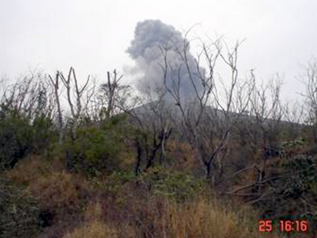 |
Figure 13. Ash plume rising from San Cristóbal on the afternoon of 25 April 2006. Courtesy of INETER. |
Activity during 2007. Rockfall noises from landslides within the crater were heard on 12 January and 6 February 2007. Landslides from the E crater wall continued on 6 March. Crater visits on 21 May and 10 June were hampered by gas emissions, especially SO2 fumes. Water levels in the crater lakes, located in the western and southern parts of the crater, were high on 22 July because of the rainy season, resulting in increased gas emissions.
On 11 August Perez observed the main crater where he noted ongoing abundant gas emissions, fan-like sounds inside the new crater, and landslides on the S crater wall. Activity on 15 September consisted of landslides on the S and W slopes, and a strong sulfur odor. Visitors to the summit on 10 November reported abundant gas and saw ash and blocks ejected during explosive activity days earlier (days were not specified). The size of the ejecta ranged from 20 x 40 cm up to 120 x 90 cm. Perez reported on 6 December that abundant gas emissions were continuing in the N part of the inner crater, accompanied by loud noises. Small landslides on the N flank were seen later in the month.
Activity during 2008. The abundant gas emission continued into January 2008 but declined in February and March. Gas emissions in April appeared heavier. On 30 April heavy gas emanation accompanied jet engine noises from within the crater. On 4 May there were continuing abundant gas emissions.
On 11 June loud sounds from the bottom of the crater occurred at intervals of 15-20 minutes accompanied by abundant degassing. On 22 June a moderate explosion generated a gas-and-ash plume. The Civil Defence Center in Managua reported minor ashfall in the city of Chinandega (~ 16 km SW) and in the communities of La Bolsa, Valle de los Morenos, and Cosmapa. Weeks before the explosion on 22 June, the number of volcano-tectonic earthquakes had slowly increased to 300 earthquakes per day (figure 14). The slightly elevated activity continued during July. A gas-rich cloud continued being expelled from the crater, accompanied by loud rumbling. On the night of July 10 an episode of seismic tremors lasted several hours. The next morning, 11 July, a series of explosions ejected gas and ash that was blown W. Local residents reported minor ashfall in the cities of El Viejo (~ 18 km WSW) Chinandega.
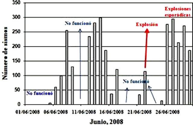 |
Figure 14. Daily number of seismic events at San Cristóbal during June 2008. The ash explosion on 22 June was preceded by elevated seismicity (recorded when the instrument was operational) and followed by both high seismicity and sporadic explosions. Courtesy of INETER. |
In early August several small explosions of ash and gas occurred. Abundant degassing continued throughout September and October. On 18 October some collapse of the crater walls was noted. Throughout that period, seismicity was high and steadily increasing from 90 earthquakes/day in August to 120 per day in September and October. During October, audible noises were heard from the crater and landslides again occurred along the crater walls.
On 6 November degassing and strong noises originated from the crater floor. Seismic tremor began to increase on 13 November; a seismic swarm took place 17-19 November with earthquakes (magnitudes 3.5-4.0) felt by residents in communities surrounding the volcano. Scans on 21 November through the volcanic plume yielded an average sulfur dioxide flux of 1,124.5 ? 212.5 metric tons /day (t/d). Small explosions that afternoon caused ashfall in Las Moras, La Bolsa, and Belén, located S of the volcano. When climbing to the crater on 10 December, Perez noted abundant ash and rocks of variable sizes expelled by the 21 November activity was deposited in the S and NE part of the crater. Abundant gas emissions from the crater continued.
Activity during 2009. January, February, and March were notable for their consistency in heavy gas emissions. In late March there were notable temperature increases at most of the vents. Eight measurements using a Mobile Mini DOAS over about 2 hours resulted in an average SO2 flux of 650 t/d. May, June, July and August were months of sustained abundant gas emission (figure 15) with very little other notable activity beyond occasional landslides, some of which obstructed gas vents. Average SO2 flux on 30 July was 1,249 t/d. Measurements made in May 2009 (274.7 t/d) were much lower. Based on analysis of satellite imagery, the Washington VAAC reported that on 19 May a diffuse plume drifted 45 km SW.
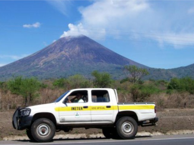 |
Figure 15. Small gas plume at the summit of San Cristóbal, May 2009. Courtesy of INETER. |
A seismic swarm on 4 September lasted about 30 minutes, and a strong explosion took place on 6 September (figure 16). An explosion on 6 September 2009 at 1350 created an ash column that reached an approximate height of 200 m; four explosions of lesser intensity followed. The Washington VAAC issued an advisory noting ash up to an altitude of 8.5 km that was drifting 75 km W. This activity continued until approximately 1440. The material ejected affected communities between the towns of Grecia and El Piloto, and along the road from Chinandega to the Guasaule border post. Perez, during a visit on 11 September, heard loud rumbling landslides into the crater and observed gas emissions. The number of daily seismic events increased on 11 September, then gradually declined throughout the month (figure 17).
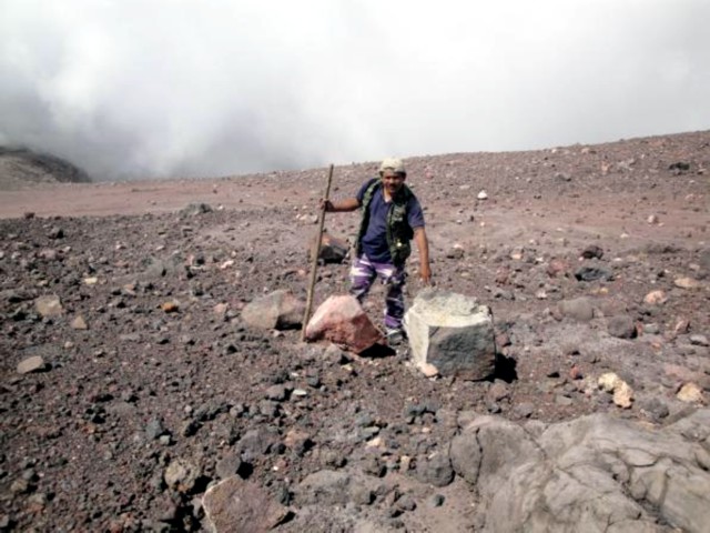 |
Figure 16. Rocks ejected by the 6 September 2009 explosion at San Cristóbal. Photo taken on 24 November; courtesy of INETER. |
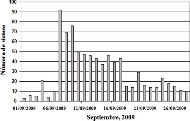 |
Figure 17. Number of daily seismic events at San Cristóbal, September 2009. Courtesy of INETER. |
On 14 September an explosion at approximately 1050 was recorded by the seismic station located on the SW flank. The column rose ~ 350 m, and ejected material fell on the Las Rojas farm and in the towns of Las Banderas and Mokoron. On 18 September the average SO2 gas-flux was 319 t/d, a significant decrease with respect to July. However, on 6 September, when about eight explosions occurred, the average SO2 flux was 1,657 t/d.
Abundant gas emissions from the NE part of the crater were see during 18 October fieldwork, though landslides had obstructed vents. On 22 October the measured SO2 flux had decreased further compared to September. Abundant emission of gases continued and the widening of the crater in the S was noted on 24 November; there were ash deposits on the solar panels of the S-flank seismic station. Landslides around the crater and gas emissions were continuing on 8 December.
Based on analyses of satellite imagery, the Washington VAAC reported that on 6 December a gas-and-steam plume, possibly containing ash, drifted SW; smoke from local fires was also noted. Based on METAR weather reports, the Washington VAAC again reported that a gas-and-steam plume possibly contained ash on 22 December. Satellite imagery from 26 December showed an ash plume drifting 90 km WSW.
Activity during January-June 2010. Gas emissions continued in 2010, with fieldwork observations on 7 January, 14 February, and 14 March. No activity was reported by Perez following a visit on 27 April. Based on analyses of satellite imagery, the Washington VAAC reported that on 9 June a well-defined ash plume drifted about 115 km WNW.
Information Contacts: Instituto Nicaraguense de Estudios Territoriales (INETER), Apartado Postal 2110, Managua, Nicaragua (URL: http://www.ineter.gob.ni/); Washington Volcanic Ash Advisory Center, Satellite Analysis Branch (SAB), NOAA/NESDIS E/SP23, NOAA Science Center Room 401, 5200 Auth Rd, Camp Springs, MD 20746, USA (URL: http://www.ospo.noaa.gov/Products/atmosphere/vaac/).
Multiple ash plumes in 2010; several summit explosions without precursors
Previously reported activity at San Cristóbal, from April 2006 to June 2010, included ash plumes and degassing (BGVN 35:04). Here we describe several substantial explosions during 2010, in addition to ash plumes that occurred without precursory activity (in 2010 and 2011). Based on Instituto Nicaragüense de Estudios Territoriales (INETER) reports, we compiled significant located seismic events for January 2010 through October 2011 and also present gas monitoring results for May 2010 through September 2011.
INETER prepared an additional report along with their monthly review of volcanic activity in December 2010. They highlighted five distinct explosive episodes at San Cristóbal's summit in April, July, September, and December 2010 and also characterized long-term unrest. During the last few decades, activity at San Cristóbal had been dominated by constant gas emissions, small ash and gas explosions, high seismicity, and specifically tremor. Prior to activity in 2010, large explosions and elevated seismicity had occurred in November 1999 (BGVN 25:02) and more recently in April 2006 (BGVN 31:09 and 35:04). Since that time, there have been smaller explosions and regular degassing.
Earthquake followed by explosion signals in April 2010. In early 2010, San Cristóbal produced increasing amounts of gas. From January through March, temperatures measured from fumaroles within the crater generally increased (figure 18). In April, seismicity was similar to the previous months: frequent tremor episodes, occasional volcanic-tectonic events with low amplitudes, and rare long-period events. On 8 April two earthquakes, ML 3.1 and 2.9, suddenly occurred beneath the S side of the volcano and local residents reported shaking in nearby towns (table 3). Following the largest, shallow earthquake a small explosion was recorded. Another explosion occurred on 18 April but the seismic record was incomplete due to problems with the station. By 27 April, reports from field investigators described quiescence within the crater (BGVN 35:04).
 |
Figure 18. Fumarole temperatures from San Cristóbal measured throughout 2010 by INETER scientists. Note some data gaps for Fumarole 5 and Fumarole 3. Courtesy of INETER. |
Table 3. The date, local magnitude (ML), and depth to epicenters are listed for significant earthquakes located near San Cristóbal. No locations were determined for January and February 2010 or November and December 2011. Courtesy of INETER.
| Date | ML | Depth (km) |
| 09 Mar 2010 | 4.4 | 1 |
| 08 Apr 2010 | 3.1 | 0 |
| 08 Apr 2010 | 2.9 | 23 |
| 09 Apr 2010 | 2.5 | 3 |
| 29 Apr 2010 | 3.7 | 169 |
| 30 May 2010 | 2.6 | 1 |
| 04 Jun 2010 | 2.7 | 2 |
| 18 Sep 2010 | 2.0 | 0 |
| 18 Oct 2010 | 2.1 | 0 |
| 02 Jan 2011 | 2.3 | 2 |
| 10 Jan 2011 | 3.5 | 61 |
| 11 Feb 2011 | 2.2 | 5 |
| 19 Feb 2011 | 2.6 | 2 |
| 01 Apr 2011 | 1.3 | 2 |
| 02 Apr 2011 | 3.2 | 5 |
| 02 Apr 2011 | 3.1 | 5 |
| 02 Apr 2011 | 2.8 | 4 |
| 17 Apr 2011 | 2.8 | 1 |
| 11 Jun 2011 | 2.1 | 2 |
| 24 Jun 2011 | 2.2 | 4 |
| 24 Jul 2011 | 1.7 | 1 |
| 14 Aug 2011 | 2.0 | 2 |
| 02 Oct 2011 | 2.3 | 1 |
| 14 Oct 2011 | 2.5 | 2 |
| 15 Oct 2011 | 2.9 | 2 |
In May and June 2010 San Cristóbal was relatively quiet. Field measurements determined that fumarole temperatures were variable. The 3-station Mini-DOAS array detected relatively low levels of sulfur dioxide; INETER reported 274 tons/day (table 4). Visual observations determined that degassing was more vigorous in June and, while banded tremor had been recorded in May, seismicity was also higher in June. On 15 June, more than 12 hours of tremor were recorded.
Table 4. The average SO2 flux per sampling period in metric tons per day from San Cristóbal measured with Mini-DOAS from May 2010 to September 2011. Courtesy of INETER.
| Month | Metric Tons/day SO2 |
| May 2010 | 274 |
| Jul 2010 | 1248 |
| Dec 2010 | 460 |
| Jan 2011 | 659 |
| Sep 2011 | 1532 |
Significant ashfall from 2 July explosions. Elevated seismicity continued into July 2010 and was dominated by low-amplitude events. On 2 July an explosion from the summit crater released a low-altitude plume of ash (described as a "mushroom cloud" in news reports) that drifted over villages located W of the volcano. Local residents heard explosions and observed a dense ash plume sustained for ~20 minutes. Ash was accompanied by ejected incandescent blocks (reporters noted that block sizes were up to 10 meters in diameter) that scattered across the summit area and started grass fires. Field investigations by INETER on 24 July found that light ash had remained on foliage and grass and there were charred trees below the summit area. Civil Protection noted that ashfall had reached these towns and districts within a 10 km radius of the crater: Las Grecias, El Piloto, El Chonco, Mokorón, and Villa. Comarca Las Grecias is located WSW of San Cristóbal (figure 19).
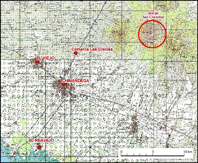 |
Figure 19. The extent of ashfall from San Cristóbal frequently reached towns W and SW of the volcanic edifice in 2010 and 2011. Light ash from the 2 July 2010 event fell on Comarca Las Grecias (~12 km SW of the summit) and other locations not marked on this map. The explosive event from 23 October 2011 caused ashfall at four sites marked here: Comarca Las Grecias, El Viejo, Chinandega (regional capital), and El Realejo (~25 km from the summit). Courtesy of INETER. |
Plumes and advisories. On 20 August 2010, a volcanic ash advisory was released for the N sector of San Cristóbal (table 5). The GOES-13 satellite detected a plume of gas and potentially light ash drifting from the summit over 35 km N. No associated activity was detected by local instrumentation that day although 10 minutes of tremor and several volcanic-tectonic (VT) events were recorded on 6 August. INETER field investigators visiting the summit on 22 August 2010 reported strong degassing and frequent rockfalls from the crater rim.
Table 5. Ash plumes from San Cristóbal reported by the Washington Volcanic Ash Advisory Center (VAAC) for June 2010 through August 2011. The 9 June event was the first to occur in 2010 and no additional reports were issued in 2011 after 21 August.
| Date | Altitude (km) | Drift |
| 09 Jun 2010 | 3.0 | WNW |
| 20 Aug 2010 | 3.0 | N |
| 15 Dec 2010 | 2.1 | -- |
| 17 Dec 2010 | 3.0 | N |
| 23 Dec 2010 | 1.8 | SW |
| 06 Jan 2011 | 2.1 | SW |
| 13 Jan 2011 | 2.1 | SW |
| 21 Aug 2011 | 6.1 | WNW |
Late 2010-early 2011 observations. Seismic activity in September 2010 was sparsely recorded due to intermittent equipment errors (local GPS malfunctioned) but seismicity from 21 September corroborated observations of activity from San Cristóbal. A series of small explosions occurred, beginning early on 21 September. Reports from Civil Defense based in Chinandega described rumbling sounds from the crater (lasting up to 20 minutes). Ashfall reached the regional capital as well as the town of El Viejo to the NW (figure 19).
INETER teams visited San Cristóbal in October and November 2010 and measured fumarole temperatures (figure 18). The team also observed strong gas emissions from the summit. Numerous rockfalls from the crater walls had occurred in October. Some tremor was recorded in October and sporadic seismicity continued into November. On 6 November, one hour of tremor was recorded. Earthquakes occurred more frequently toward the end of the month. Interesting sequences of VT events were recorded that lasted 15-20 minutes with frequencies of 3-5 Hz.
In early December 2010, seismicity gradually increased. Long-period events (LP) dominated the record and some VTs were recorded with frequencies of 1-3 Hz. Without any apparent precursory activity, a small explosion was recorded on 13 December at 0638 (figure 20).
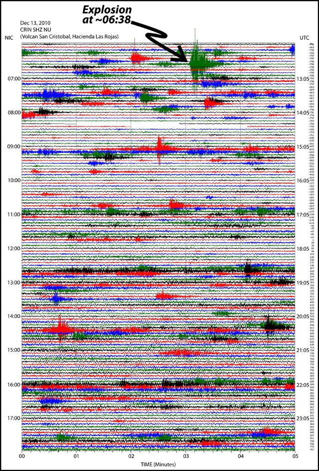 |
Figure 20. Seismicity on 13 December 2010 from San Cristóbal. The impulsive explosion was recorded at ~0638 from seismic station CRIN. Courtesy of INETER. |
An ash plume was reported by a local pilot at the time of the seismic signature. Elevated seismicity did not occur until after the explosion, when low-frequency tremor appeared in the records. Three subsequent volcanic ash advisories were issued by the Washington VAAC for the area on 15, 17, and 23 December (table 5).
Dense plumes of gas were emitted in early January 2011 and reported by Washington VAAC (table 5). Low-altitude plumes (2.1 km) and cloudless days provided excellent conditions for INETER scientists to detect SO2 flux on 21 January 2011. Traverses under the plume with a mobile Mini-DOAS collected data along points between Chinandega (SW of San Cristóbal) and Las Grecias (to the NW). INETER discussed the slight increase (~200 tons/day since December 2010, table 4) in SO2 in their monthly report and attributed elevated emissions to the general increase in seismicity during the last few months (table 3) and to changes in the volcano's structure.
Throughout 2011, field investigations by INETER included monitoring fumarole temperatures within the summit crater (figure 21). During 2011, temperatures from five separate fumaroles ranged between 50 and 90°C. Similar to measurements taken in 2010, intermittent values were recorded for Fumarole 5 (Fumarole 4 was also intermittent, no measurable value in June). Data collection was not possible in November and measurements in December clustered at comparatively elevated temperatures of 80 and 90°C.
 |
Figure 21. Fumarole temperatures from San Cristóbal measured throughout 2011 by INETER scientists. Some data gaps for Fumaroles 4 and 5; no measurements were taken in November. Courtesy of INETER. |
Within the summit crater during 2011, investigators found evidence of rockfalls as well as ground cracks at the crater rim. INETER described gradual accumulation of debris on the crater floor from February through April. During a field visit in May, two small pools of water had appeared within the crater. These features persisted from May through July.
Ash event without unrest. A sudden ash explosion was reported by Chinandega Civil Defense at 1900 on 23 October 2011. Ash fell over Chinandega (the regional capital) as well as El Viejo, El Realejo, and the district of Las Grecias (figure 19). Minor tremor events occurred during the day but signals suggesting explosions were absent. Tremor continued to appear in the seismic record during November through the end of December.
Information Contacts: Instituto Nicaragüense de Estudios Territoriales (INETER), Apartado Postal 2110, Managua, Nicaragua (URL: http://www.ineter.gob.ni/); Washington Volcanic Ash Advisory Center (VAAC), Satellite Analysis Branch (SAB), NOAA/NESDIS E/SP23, NOAA Science Center Room 401, 5200 Auth Rd, Camp Springs, MD 20746, USA (URL: http://www.ospo.noaa.gov/Products/atmosphere/vaac/); La Prensa (URL: http://www.laprensa.com.ni/2010/07/04/nacionales/30240); El Nuevo Diario (URL: http://www.elnuevodiario.com.ni/nacionales/78105).
Monitoring efforts and 8 September 2012 explosive eruption
When last active in October 2011, San Cristóbal produced ash plumes accompanied by elevated seismicity (BGVN 36:12). This report covers the January-September 2012 monitoring efforts (seismic, gas, thermal, and visual observations) and the onset of a volcanic crisis during 8-15 September 2012. Seismicity remained high through early 2012 and tremor was frequently detected. Explosions of ash and gas began impulsively from the summit crater on 8 September causing heavy ashfall, evacuations of local populations, and aircraft deviations.
January-September 2012 seismicity. Instituto Nicaragüense de Estudios Territoriales (INETER) detected seismic tremor every day in January 2012 and throughout much of February, March, and April. A station outage took place during 1-14 June, but when the data stream returned, it recorded significant tremor. INETER reported a generally increasing trend in earthquake counts from January through April (figure 22).
 |
Figure 22. Total earthquakes detected from San Cristóbal during January-April 2012. Courtesy of INETER. |
In January, tremor persisted for 1-12 hours per day for a total of 118 hours. In February, tremor duration averaged 4 hours/day (131 hours); in March, 6 hours/day (166 hours); in April, 2 hours/day (38 hours); and in June, 5 hours/day (23.5 hours). No estimates were available for May.
From January through April 2012, a class of seismic events considered "degassing earthquakes" (DE) were detected throughout the seismic records. These events were characterized in spectrograms as events in the range of 4-10 Hz. INETER described the events as resulting from gas moving through the conduit, causing displacements and, after building pressure in confined spaces, the pressure was released impulsively, generating low-amplitude shockwaves and arriving as emergent seismic signals with low energy. These conditions suggested that the volcanic system was partially open (as opposed to a closed system that would be expected to pressurize). Individual DEs occurred with durations of ~60 seconds, and up to 1,379 DE events were recorded in April 2012 with dominant frequencies of 5-10 Hz.
Volcano-tectonic (VT) earthquakes were a minor part of San Cristóbal's seismicity during January-June. Typically occurring 6-15 km deep, the maximum number of VT events occurred in March; 39 earthquakes were detected with dominant frequencies in the range of 10-20 Hz.
Long-period (LP) earthquales dominated the seismic record in June; 1,413 events were recorded (22-707 monthly events were noted in the records during February-April). The duration of these signals ranged from 40-90 seconds with dominant frequencies of 1-5 Hz. Depths of these events were not announced, but in March and April, LPs occurred at depths of 6-25 km.
Reports from INETER during the volcanic crisis in September highlighted sporadic signals indicating eruptions in the seismic records along with tremor and the appearance of shallow, low-magnitude events (microseismicity). Elevated seismicity on 8 September decreased dramatically by 10 September. Seismic tremor increased on 14 September, however, by 16 September, seismicity had returned to normal levels.
SO2 monitoring. In January 2012 INETER reported that three miniature Differential Optical Absorption Spectrometer (Mini-DOAS) stations were installed in the field around the flanks of San Cristóbal. These stations stored SO2 flux data locally and telemetered it to the INETER network through the El Chonco repeater. These installations were part of the Network for Observation of Volcanic and Atmospheric Change (NOVAC), a collaboration supported by the European Union's Natural Disasters Program (Galle and others, 2009).
Employing a mobile DOAS, INETER collected SO2 data on traverses in March; five traverses were made between the junction of Chinandega and Corinto and the town of Las Grecias (for town locations, see BGVN 36:12 figure 20). The average SO2 flux recorded on 30 March 2012 was 542 t/d; the reported wind velocity was 5 m/s to the E. Previous measurements from this region (10 January 2011) yielded an average SO2 flux of 436 t/d.
Thermal data and visits to the summit. INETER technicians noted regular gas emissions from San Crisóbal's summit from January through August 2012. During field investigations to the summit (April-August 2012), loud jetting was heard one day (22 April) coming from the central crater. That day, gas emissions were relatively low and there was evidence of numerous rockfalls from the W side of the crater. Vapor plumes drifted mainly W and E of the crater depending on wind direction.
Fumarole temperatures measured from April through August show small variations in the range of 50-93°C (figure 23). These measurements were taken from five sites located within the SE sector of the crater rim. The previous temperature from the central crater was last measured on 3 December 2011 (382°C); the most recent measurement, on 20 June 2012, was 543.7°C.
 |
Figure 23. (Top) Site locations of fumaroles found along the SE summit rim of San Cristóbal and visited in 2012. The white color is due to heavy steam emissions which have conformed with the topography due to GoogleEarth 3D rendering. (Bottom) Fumarole temperatures (grouped by fumarole) during April-August 2012. INETER noted that lowest temperatures were obtained from Fumarole 2 (50-73°C) while other sites showed variations between 70 and 93°C (the maximum measured from Fumarole 5). Courtesy of INETER. |
Heavy rain in May restricted field operations, however, on 24 May INETER technicians visited the lower flanks of San Cristóbal to maintain seismic and gas instrumentation. They encountered evidence of a lahar that had covered the main trail between the Hacienda Las Rojas and Pedro Marín to the SW of the summit. The lahar had reached a maximum height of 0.8 m and was up to 15 m wide.
Field investigations to the summit on 20 June determined that deep channels had been eroded in the W flank of the volcano, exposing loose soil (figure 24). INETER advised vigilance for this region since the soil could easily remobilize as a mudflow with heavy rainfall. The W flank was particularly at risk due to a forest fire that, in April 2012, removed significant vegetation that would otherwise have provided some stability for the steep slopes. Particularly vulnerable locations would be the areas of Las Rojas and Pedro Marín, farming areas within the drainage network on the W flank.
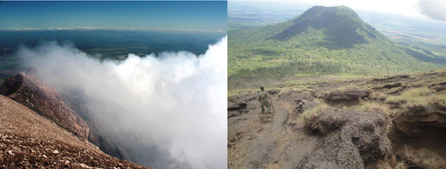 |
Figure 24. Views from the summit of San Cristóbal volcano on 20 June 2012. (Left) A diffuse plume of vapor that reached ~200 m above the summit crater, drifting NE. (Right) With the El Chonco peak in the distance, INETER staff photographed fresh signs of erosion on the W flank of the volcano attributed to recent heavy rainfall. Courtesy of INETER. |
Ash explosions in September 2012. At 0845 local time on 8 September, a substantial ash plume erupted suddenly from San Cristóbal's summit, followed by a second plume 10 minutes later. Later that day, INETER confirmed GOES-13 satellite observations of a wide-spreading ash plume from the summit of San Cristóbal (figure 25). Three explosions produced ash-and-gas plumes that day and were observed rising up to 1.5 km above the crater and drifted 9 km/hr NW (figure 26).
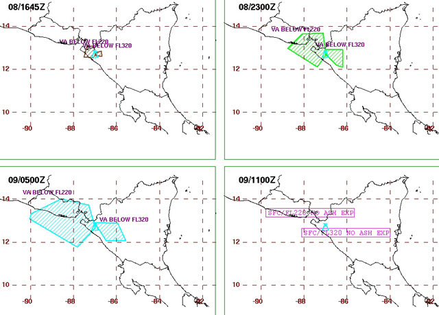 |
Figure 25. Distribution of ash plumes from the 8 September summit explosion of San Cristóbal. The top left image (at 1645 UTC) represents a best fit polygon of the ash plume based on satellite imagery while the other images are the forecasted distributions of the plume for the following 6, 12, and 18 hours. Courtesy of Washington VAAC. |
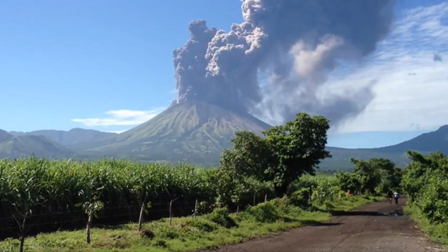 |
Figure 26. A still-shot from a video taken of the dense ash plume from San Cristóbal on 8 September 2012. The location of this recording was not disclosed but the view is directed S with the El Concho peak to the far right-hand side. Time of the video was undisclosed. Courtesy of YouTube contributor A Callejas. |
On 8 September INETER released special online reports announcing observations and volcanic crisis incidents. Residents reported ashfall at El Viejo (18 km WSW of San Cristóbal), El Chonco, and Ranchería. Sporadic explosions later that day generated ash plumes that rose 1.5-5 km and drifted 50 km WNW. The sporadic explosions appeared in the seismic records but microseisms (a category of shallow, small-magnitude earthquakes) dominated the record.
Between 0900 and 1000 local time on 8 September, SO2 flux was 3,221 t/d, well above the normal range of 550-700 t/d. Residents in Versalles Arriba, a zone near the crater, reported seeing a fissure-like feature, however, INETER did not report follow-up site visits for this observation. Rockfalls were observed on the N flank; on the NW flank, ash mixed with incandescent rock fell in an area occupied by livestock. Field investigators noted that six animals were burned from this event.
According to a news article, emergency officials evacuated ~3,000 people by 1857 local time. The national emergency agency of Nicaragua (Sistema de Prevención, Mitigación y Atención de Desastres, SINAPRED) reported that airplanes were diverted around San Cristóbal to other routes.
Rainfall was closely monitored on 8 September. By 1600 local time, 26.1 mm of rain had fallen and INETER warned of possible mudflows resulting from remobilized ash. Thunderstorms were expected on 9 September in the region of Chinandega and INETER warned that acid rain could result from the mixture of volcanic gases.
During 9 September, INETER coordinated field teams that investigated ashfall within the region. These teams determined that ash fell in an area covering 2,438 square kilometers, including the communities of El Viejo, La Grecia, La Joya, Santa Catalina, El Piloto, Las Banderas, Las Rojas, Carlos Fonseca, Jiquilillo, Mechapa, and Cosiguina (figure 27). Ashfall was 5 cm thick in areas near the crater and up to 3 mm thick in more distant places.
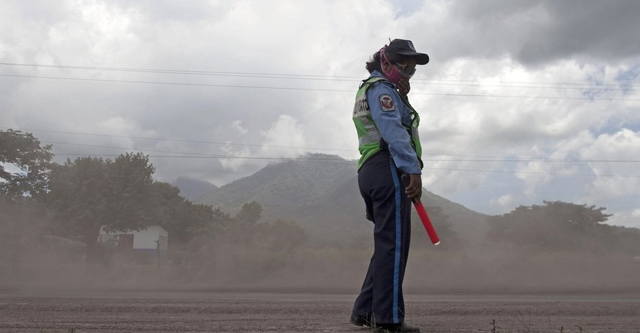 |
Figure 27. Several towns and roads were blanketed with ash from San Cristóbal on 8 September. This Nicaraguan police officer wears a protective mask to prevent inhaling the fine volcanic ash. Courtesy of the Associated Press/Esteban Felix. |
By 10 September, INETER reported that seismicity decreased after the 8 September eruption. A traverse between Chinandega and El Guasaule during 0700-0830 with a mobile DOAS measured an SO2 flux of 1,626 t/d. This emission rate was significantly lower compared to the previous day.
During 10-11 September, steam plumes rose 200-300 m above the crater and drifted W. Three small explosions on 11 September generated ash-and-gas plumes that rose 300 m above the crater and drifted W. An explosion and ash venting was observed a few hours later; a plume drifted S and ash fell on the flanks. Microseismicity continued; at 0900 on 11 September, 63 small events had been recorded so far that day.
Abundant gas emissions were observed on the morning of 12 September. RSAM was notably higher (by 35 to 70 RSAM units compared to the previous day). At the time of the Special Report on 12 September at 1100 local time, 86 microseismic events had been recorded.
On 13 September, INETER reported that the seismic network continued to detect small, sporadic explosions. Sulfur dioxide gas emissions were above normal (1,360 t/d), similar to levels detected on 8 September. RSAM calculated since the release of the last INETER Special Report was considered normal, 40-60 RSAM units, and microseismicity appeared to have decreased (only 17 events had been detected).
Fieldwork was conducted on 13 September as a joint venture between INETER and the El Salvadoran agency Servicio Nacional de Estudios Territoriales de El Salvador (SNET). The scientific team reached the summit crater of San Cristóbal to measure temperatures, collect rock samples, and observe current conditions. They noted that portions of the crater had collapsed (N and S sectors) and found blocks and ejecta on the flanks, 850 m from the crater. Changes had also occurred in the summit fumarolic areas. Three of the five fumarolic sites no longer emitted gas; these sites appeared to be sealed. Fumaroles 1 and 2 had measurably elevated temperatures (85°C), broadly similar to previous values recorded (figure 23). Based on the field assessment of ejecta, INETER warned that mudflows remained a hazard during heavy rainfall.
Increased seismic tremor was recorded at 0340 on 14 September. Low levels of summit emissions were visible drifting in a plume to the SW. Elevated SO2 flux continued (2,490 t/d). The following day, abundant gas emissions were visible drifting NE and SO2 emissions had increased (3,054 t/d). RSAM had increased to 120 on 15 September. A small explosion was detected at 0817 local time; however, there was no visual confirmation due to cloud cover.
Early in the morning on 16 September, minor tremor was recorded and few earthquakes were recorded. The seismic events were too small to be located and INETER reported that, based on RSAM, seismicity had returned to normal levels (40 RSAM units). Low level emissions were visible and less SO2 was detected compared to the previous two days (2,053 t/d). By 17 September, no tremor was recorded and minor emissions were visible drifting N of the crater.
References. A Callejas, 2012, Volcan San Cristobal en erupción - Nicaragua Sept 8, 2012 (from YouTube), Uploaded on 10 September 2012, Accessed on 3 October 2012, http://www.youtube.com/watch?v=hQStun1FF3o&feature=related.
Galle, B. and the NOVAC Team, 2009. NOVAC - A global network for volcanic gas monitoring, 6th Alexander von Humboldt International Conference, Abstract AvH6-34-1, 2010.
Information Contacts: Instituto Nicaragüense de Estudios Territoriales (INETER), Apartado Postal 2110, Managua, Nicaragua (URL: http://www.ineter.gob.ni/); Washington Volcanic Ash Advisory Center (VAAC), Satellite Analysis Branch (SAB), NOAA/NESDIS E/SP23, NOAA Science Center Room 401, 5200 Auth Rd, Camp Springs, MD 20746, USA (URL: http://www.ospo.noaa.gov/Products/atmosphere/vaac/); La Prensa de Nicaragua (URL: http://www.laprensa.com.ni/2010/07/04/nacionales/30240); La Prensa de Honduras (URL: http://www.laprensa.hn); BBC: Latin America & Caribbean (URL: http://www.bbc.co.uk/news/world-latin-america-19533933).
Ash eruption during 25-28 December 2012
Our last report highlighted monitoring efforts at San Cristóbal and the explosive eruption that began on 8 September 2012 (BGVN 37:08). By 16 September 2012, seismicity and emissions had decreased; however, the Instituto Nicaragüense de Estudios Territoriales (INETER) announced in late December 2012 that volcanic activity had re-started. In this report, we cover the time period of 25-31 December when seismicity, explosions, and gas-and-ash emissions were reported.
At 2000 on 25 December 2012, observers noted a series of gas-and-ash explosions from the summit. The wind carried the fine- to sand-sized ash SW. Several hours prior to this activity, INETER had reported that seismicity was elevated but sulfur dioxide emissions (SO2) were relatively low compared to measurements from previous days.
During the early hours of the morning on 26 December, winds dispersed fine ash NW, W, and SW. Sand-size ash was fell on the W and SW flanks (figure 28). Civil Defense authorities from the municipality of Chinandega reported an ash plume up to 500 m above the summit and described the event as a "moderate eruption" similar to the 8 September 2012 event.
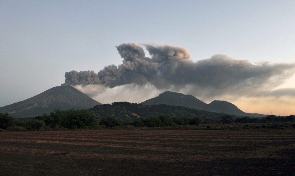 |
Figure 28. A view S toward San Cristóbal with an ash plume drifting westerly on 26 December 2012. The lower hills to the right are part of El Chonco, an older volcanic edifice. Photograph by Hector Retamal, AFP, Getty Images. |
On 26 December, government officials reported to Reuters that local inhabitants were evacuating. Rosario Murillo, a government spokeswoman, called on residents within a 3 km radius of the volcano to leave the area; some families had already self-evacuated.
By 1000 that day, INETER reported that seismicity had increased, and that they had received reports from Civil Defense stating that an eruption of fine ash rose to ~2,500 m above the crater. By the early afternoon, four major seismic events were detected and interpreted as explosions at the summit. Ashfall from these events primarily affected an area within a 5-6 km radius of the summit: El Viejo, Las Rojas, Banderas, Abraham Rugama, and those communities north of Chinandega's urban limit Grecia (particularly two communities called #1 and #4; see figure 19 in BGVN 36:12 for major town locations).
In their second communication on 26 December, INETER suggested that local inhabitants protect their water sources from ashfall, particularly those communities W, SW, and S of the volcano. They also announced that grazing lands would be closed in those regions due to the quantity of ash that had fallen. Research at Raupehu, New Zealand, and elsewhere has found that grazing animals can suffer damage to their teeth and poisoning due to elevated sulfur and fluorine if they consume ash-covered plants (Cronin and others, 2003). Precautions were also recommended for young children who could be adversely affected by inhaling fine ash. INETER noted that aviation traffic had been alerted to the presence of ash in the region.
The Washington Volcanic Ash Advisory Center (VAAC) detected ash from San Cristóbal during 26-28 December. Emissions were ongoing during that time period; plumes rose 2.4-4.3 km a.s.l. and drifted approximately W over the Pacific Ocean as far as 670 km WNW from the summit (figure 29).
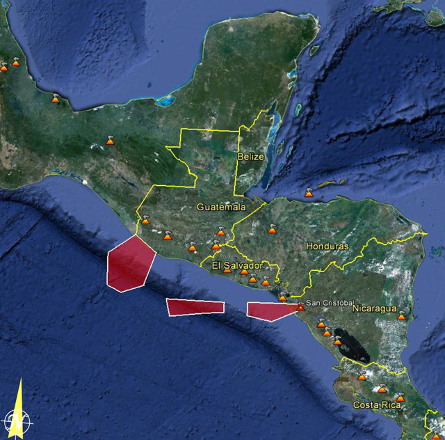 |
Figure 29. The aerial extent of observed volcanic ash from San Cristóbal was concentrated in three discrete regions mainly offshore of Central America at 0430 on 28 December 2012. The red polygons were developed by the VAAC as geospatial files (KML) for display in Google Earth. Courtesy of Washington VAAC and Google Earth. |
INETER reported to local news agencies that 7 of the 13 municipalities of Chinandega were affected by ashfall by 27 December. Visibility was greatly reduced within the urban city of Chinandega. Emissions continued from the summit and reached 200 m above the crater rim in the morning. At the time of their second online notice, a plume of fine ash was visible rising up to 500 m above the crater, and small-to-moderate sized explosions of gas and ash continued.
On 28 December, the minister of Agriculture and Forestry told the local news agency, La Jornada, that while 2 millimeters of ash had fallen in some areas around the volcanic edifice, the farming areas should not be adversely affected since most of the crops had already been harvested. The public utility company, ENACAL, conducted investigations into water quality for the region.
News agencies reported that up to 20 km of highway was affected by ashfall along the Pan-American Highway between Honduras and Nicaragua. Vehicles opted to use headlights due to reduced visibility. La Jornada reported that a total of 268 people had left the area of San Cristóbal by 28 December and 68 were evacuated by the national humanitarian agency (Nicaraguan Humanitarian Rescue Unit, UHR).
INETER reported that small to moderate sized explosions had occurred in the morning of 28 December and a significant increase in SO2 flux was detected. This announcement included warnings regarding eye, skin, and respiratory irritation due to volcanic gases. There were also recommendations regarding ash removal from roofs and structures. Ash was distributed NW, W, and SW from the volcano and satellite images detected ash extending across the Pacific Ocean following the regional airstream offshore of El Salvador.
After an explosion of ash and gas at 1100 on 28 December, emissions throughout the day were ash-poor. Seismicity also decreased that day and, by 29 December, explosions had ceased and diffuse gas emissions continued. In their online bulletin, INETER reported that, as of 31 December, no ash explosions had been detected over the past two days. Gas emissions continued from the summit but SO2 levels had returned to normal.
Volcanic hazards map for San Cristóbal. A map of volcanic hazards was available on the INETER website for the region of San Cristóbal (figure 30). Volcanic ballistics, lahars, landslides, lava flows, and tephrafall were assessed and likely impacted areas were delineated. The tephrafall region corresponded to the prevailing winds and correlated well with ash-effected regions during the December 2012 events.
 |
Figure 30. Volcanic hazards from San Cristóbal include ejecta, lahars, landslides, and lava flows. This map was released in April 2006 and developed to show the aerial extent of potential events. Densely populated regions are yellow, road systems are black, and rivers are blue; additional color regions correspond to hazards listed in the key (in Spanish). The brown circle has a radius of 5 km and encompasses the main volcanic edifice indicating the maximum expected extent of ballistics (volcanic bombs for example); the two tan regions indicate the extent of possible tephra fall (where lighter shading indicates a medium-level risk zone and darker is higher-level risk); red regions follow major drainages where lahars and landslides could occur; the region shaded pink encompasses the areas most likely effected by future lava flows. Courtesy of INETER. |
Reference. Cronin, S.J., Neall, V.E., Lecointre, J.A., Hedley, M.J., and Loganathan, P., 2003, Environmental hazards of fluoride in volcanic ash: a case study from Ruapehu volcano, New Zealand, Journal of Volcanology and Geothermal Research, 121, 271-291.
Information Contacts: Instituto Nicaragüense de Estudios Territoriales (INETER), Apartado Postal 2110, Managua, Nicaragua (URL: http://www.ineter.gob.ni/); Washington Volcanic Ash Advisory Center (VAAC), Satellite Analysis Branch (SAB), NOAA/NESDIS E/SP23, NOAA Science Center Room 401, 5200 Auth Rd, Camp Springs, MD 20746, USA (URL: http://www.ospo.noaa.gov/Products/atmosphere/vaac/); La Jornada (URL: http://www.lajornadanet.com/diario/archivo/2012/diciembre/28/1.php); La Prensa de Nicaragua (URL: http://www.laprensa.com.ni/2012/12/27/ambito/128746/imprimir); Reuters.
Explosions on 7 June 2013; gas-and-ash emissions in early 2014
Our last Bulletin report covered seismicity and explosions at San Cristóbal through 31 December 2012 (BGVN 38:01).
2013. The Instituto Nicaragüense de Estudios Territoriales (INETER) reported that on 7 June 2013 seven explosions at San Cristóbal, that ejected gas and ash, were detected by the seismic station located on the W flank. The explosions occurred at 0615, 0645, 0653, 0911, 1137, 1139, and 1143, and were observed by civil defense and INETER staff. The largest explosion, at 1139, generated a plume that rose 100 m. Sulfur dioxide (SO2) emissions, which had been low, increased. A report later that afternoon stated that gas-and-ash explosions decreased, but RSAM values almost tripled to between 80 and 100 units due to increased tremor. INETER noted that tremor is frequently detected at San Cristóbal, and for the public not to be alarmed. A small mud flow, producing no damage, occurred at 1710.
2014. INETER reported that seismic tremor increased at 0340 on 17 January; RSAM values increased to 460 units from a baseline of 70 units. Twelve gas emissions were observed between 1259 and 1315, and RSAM climbed to 649 units. A report at 1700 noted that RSAM values decreased to 100 and no additional gas emissions were observed. The next day RSAM values fluctuated between 90 and 190 units.
INETER reported that a gas emission with small amounts of ash rose from San Cristóbal between 0641 and 0850 on 4 February. Although there was no increase noted, the report stated that seismicity decreased to background levels. By the afternoon SO2 emission values were 2,000-3,000 tons per day, the normal levels, and on 7 February, they were 1,000 tons per day. RSAM fluctuated between 20 and 140 units, which is considered normal.
Based on analysis of satellite images, the Washington VAAC reported that on 11 April a gas plume from San Cristóbal that possibly contained small amounts of ash drifted 20 km W. A thermal anomaly was present in short wave infrared satellite images. Periods of elevated seismicity were also detected.
Information Contacts: Instituto Nicaragüense de Estudios Territoriales (INETER), Apartado Postal 2110, Managua, Nicaragua (URL: http://www.ineter.gob.ni/); and Washington Volcanic Ash Advisory Center (VAAC), Satellite Analysis Branch (SAB), NOAA/NESDIS E/SP23, NOAA Science Center Room 401, 5200 Auth Rd, Camp Springs, MD 20746, USA (URL: http://www.ospo.noaa.gov/Products/atmosphere/vaac/).
Intermittent explosions of gas and minor ash emissions, February 2014-August 2015
Intermittent ash and gas explosions have occurred at San Cristóbal since a moderate explosion on 8 September 2012 (BGVN 37:08). Subsequent explosions were reported on 25-28 December 2012, 7 June 2013, and 17 January 2014 (BGVN 38:01 and 38:12), often with ash falling on nearby communities. Between 18 January 2014 and August 2015 several additional moderate gas and ash explosions occurred, along with hundreds of smaller gas explosions. Information in this report came from monthly reports, briefing notes, and daily news bulletins issued by the Instituto Nicaragüense de Estudios Territoriales (INETER), and the Washington VAAC (Volcanic Ash Advisory Center).
Activity during 2014. INETER reported that a gas emission with small amounts of ash rose from San Cristóbal between 0641 and 0850 on 4 February 2014. The number of seismic events dropped dramatically from 9,328 in February to only 82 in March, primarily recording degassing events. No explosions occurred in March, and fluctuations in SO2 output corresponded to variations in RSAM values.
Based on analysis of satellite images, the Washington VAAC reported that on 11 April 2014 a gas plume that possibly contained small amounts of ash drifted 20 km W from the summit; no altitude was given. A thermal anomaly was present in short-wave infrared (MODIS/MODVOLC) satellite images.
Two lahars were recorded on June 1 on the seismographs, but they caused no significant damage.
According to the July 2014 INETER monthly report, two gas-and-ash explosions occurred on 20 July, one at 1331 and a second at 1413. The column of ash and gas from the first explosion reached a height of 1,000 m and drifted W and SW. Ash from the second, smaller explosion reached several communities W and NW of the volcano, including El Viejo (18 km SW), Rancherias (8 km NW), and sections of the Panamerican Highway to the W and NW.
In August INETER staff observed gas mixed with a small amount of ash emitting from fumaroles on the northeast wall of the crater. The plumes did not rise above the crater rim. A small lahar occurred on the west side of San Cristobal on 24 September.
At 1130 on 1 October 2014 a sharp increase in seismicity was followed 10 minutes later by a series of explosions lasting less than 10 minutes. Small amounts of ash drifted N toward Santa Cruz, Rancheria, and San Jose del Obraje (10 km N).
Activity during 2015. After a few months of relative calm, small gas plumes, detected by the seismic stations on the flank of the volcano, rose a few meters above the crater rim on 19 and 23 January 2015. Correlation of SO2 emissions, RSAM values and the exhalations are shown in figure 31.
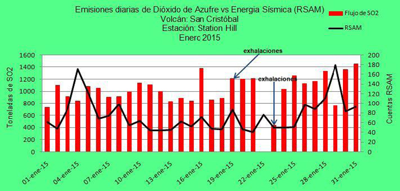 |
Figure 31. Graph of SO2 emissions, RSAM values of seismic energy, and the dates of small gas explosions from January 2015. Courtesy of INETER. |
Gas emissions were reported as moderate and abundant for February 2015, with plumes drifting WSW and NW just above the crater.
On 5 March 2015 at 1445 a series of explosions sent ash 500 m above the crater according to INETER. Visual inspection of the crater in April revealed strong hydrothermal alteration in the rocks and soil of the southern part of the crater, and collapse of portions of the crater floor from the explosions in March. Most of the 3,147 seismic events recorded in April were related to degassing (2,372); no ash plumes were reported. A slight decrease in the number of seismic events, to 2,812 was recorded in May 2015.
Explosive activity resumed in June 2015 with two series of explosions. On 6 June, about 41 explosions occurred between 1354 and 1625. The strongest one was at 1355, and generated an ash plume that rose 200 m above the crater rim; ashfall was reported in Chinandega (15 km SW). On 12 June a larger explosion at 0907 generated a gas-and-ash plume that rose 2,000 m and drifted SE, but ashfall was not reported. A second explosion that day at 1835 produced a gas plume with low ash content; the height of the plume could not be determined due to heavy rain. Seismic signals detected a lahar a few minutes later between 1850 and 1929; an observer reported that the small lahar descended the W and SW flanks. No further explosions were reported through August 2015.
Information Contacts: Instituto Nicaragüense de Estudios Territoriales (INETER), Apartado Postal 2110, Managua, Nicaragua (URL: http://www.ineter.gob.ni/); Washington Volcanic Ash Advisory Center (VAAC), Satellite Analysis Branch (SAB), NOAA/NESDIS E/SP23, NOAA Science Center Room 401, 5200 Auth Rd, Camp Springs, MD 20746, USA (URL: http://www.ospo.noaa.gov/Products/atmosphere/vaac/); Sistema Nacional para la Prevención, Mitigación y Atención de Desastres (SINAPRED) (URL: http://www.sinapred.gob.ni/).
Ash explosion on 22 April 2016
After ash explosions on 6 and 12 June 2015 (BGVN 40:09), San Cristóbal remained quiet for the rest of the year. Monthly reports from INETER (Instituto Nicaragüense de Estudios Territoriales) described degassing from the fumarolic vents which had consistent temperature variations in the 60° to 80°C range as regularly measured since December 2014. Landslides on the S and SE flanks of the inner crater were observed in November 2015. The number of seismic events continued a downward trend from 510 in September 2015 to 147 events in December. Over 90% of the events were related to degassing, with the remainder being VT (volcano-tectonic), LP (long-period), or tremor events. RSAM values generally remained in the background range of 25-30 units.
Seismicity remained low in January 2016 with only 130 seismic events recorded and RSAM values between 30 and 40 units. Observations of the gas plume indicated that it generally drifted WSW or NW, rising only a small distance above the summit.
At 1020 on 22 April 2016 both INETER and SINAPRED (Sistema Nacional para la Prevencion, Mitigacion y Atencion de Desastres) reported an explosion which sent an ash-and-gas plume 2 km above the crater that drifted SW. The seismic network recorded 10 additional explosions by 1200. Ashfall was reported in local areas, including Las Brisas (10 km S), San José (8 km SSE), Santa Narcisa, Pellizco Central (12 km SSE), Los Ébanos, Los Lirios (18 km WSW), Santa Cruz (35 km SE), Las Grietas (14 km E), El Liberal, and San Lucas (13 km E). The INETER report noted that this event was larger than the explosive activity in June 2015.
Continued temperature observations of the fumaroles from the SE part of the crater in June 2016 showed little variation from average values over the last two years (figure 32).
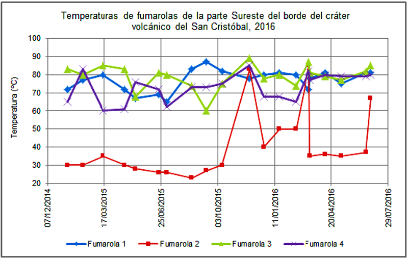 |
Figure 32. Fluctuations of fumarole temperatures from the SE part of the crater at San Cristobal from December 2014 through June 2016 show consistent variation and range of values. Courtesy of INETER (Monthly Report, June 2016). |
INETER periodically measures SO2 emissions from San Cristobal. Measurements in June 2016 from two separate transects returned average values of 558 and 477 tons per day on 10 and 24 June, respectively. The transects covered regions 10-15 km from the volcano on the west side. The values were very similar to those collected in October 2015.
Information Contacts: Instituto Nicaragüense de Estudios Territoriales (INETER), Apartado Postal 2110, Managua, Nicaragua (URL: http://www.ineter.gob.ni/); Sistema nacional para la Prevencion, Mitigacion y Atencion de Desastres (SINAPRED), Edificio SINAPRED, Rotonda Comandante Hugo Chávez 50 metros al Norte, frente a la Avenida Bolívar, Managua, Nicaragua (URL: http://www.sinapred.gob.ni/)
Intermittent ash-bearing explosions during 2017; ash plume drifts 250 km in August
Nicaragua's San Cristóbal volcanic complex has exhibited sporadic eruptive activity dated back to the early 16th century. More consistent modern record keeping has documented short-lived eruptive episodes every year since 1999. Small explosions with intermittent gas-and-ash emissions are typical. Three single-day explosive events were reported in 2015; a series of explosions on 5 March 2015 generated a 500 m high ash plume, 41 explosions on 6 June 2015 ejected ash 200 m above the summit, and the first of two explosions on 12 June 2015 sent an ash plume 2,000 m above the summit. The next eruption did not occur until 22 April 2016 when 11 explosions were recorded, with the largest sending an ash plume 2,000 m above the summit. Activity from July 2016-December 2017 is covered in this report. Information is provided by the Instituto Nicaragüense de Estudios Territoriales (INETER), and the Washington Volcanic Ash Advisory Center (VAAC).
Following little activity during the remainder of 2016 after the 22 April explosions, small explosions with minor ash were reported in February, March, and April 2017. Significant explosions during 18-19 August sent ash plumes over 200 km W and deposited ash in numerous communities. Seismicity was high during October-December 2017, but ash-bearing explosions were only reported on 7 and 11 November.
After the 22 April 2016 explosions, San Cristóbal remained quiet for the remainder of 2016. In the month's they were measured, 45-72 degassing-type seismic events were recorded. During a field visit on 29 November 2016, new landslides around the crater rim, both inside the crater and down the outer flanks, were observed. These were interpreted by INETER scientists as resulting from a major tectonic earthquake that occurred offshore in mid-November that was felt in nearby Chinandega (16 km SW), and not from volcanic activity.
Seismic activity increased slightly in January 2017 with 100 degassing events recorded. INETER reported 15 small ash-and-gas explosions during 18-19 February and 153 degassing events. There were no reports of ashfall in the nearby communities. Only 27 degassing seismic events were reported in March; three small gas explosions with minor ash occurred on 16, 25, and 28 March 2017.
Eight small explosions with gas and minor ash took place during April 2017 on days 13, 15, 16 and 19, but no damage was reported in nearby communities. Very low values of SO2 (averaging 147 tons/day) were measured at the end of April 2017, far less than values of 854 and 642 measured in September and October 2016. Degassing-type seismic events increased sharply beginning on 20 April, totaling 1,931 events; they remained elevated through 25 April.
Volcano-tectonic (VT) earthquakes increased significantly to 235 recorded events during May, from values in the single digits earlier in the year. Minor fumarolic activity occurred at the S side of the summit crater on 27 May 2017 (figure 33). Two small gas explosions were recorded on 20 and 27 May, but no ash emissions were reported. A significant increase to 2,349 degasification-type earthquakes was reported during June 2017; slightly fewer (1,981) were reported during July.
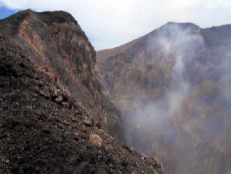 |
Figure 33. Minor fumarolic activity was observed at the S side of the summit crater at San Cristóbal during a field visit by INETER on 27 May 2017. Courtesy of INETER (Boletín mensual, Sismos y Volcanes de Nicaragua, Mayo 2017). |
Significant explosions early on 18 August 2017 were observed from Chinandega with notable gas and ash emissions (figure 34), and ashfall was deposited around the region (figure 35). Communities affected by the ashfall were located to the W and SW of the volcano and included Belén, La Mora, La Bolsa, El Viejo (18 km WSW), La Grecia, Realejo (25 km SW) and Corinto (30 km SW). Ash plumes rose between 300 and 600 m above the crater rim and drifted W and SW. Additional explosions occurred the next day but had ceased by 20 August.
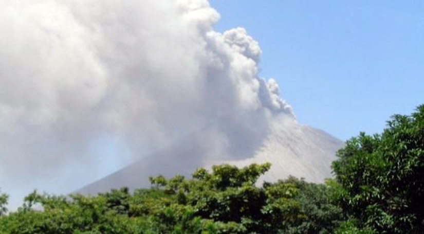 |
Figure 34. Explosion and ash plume at San Cristóbal at 1330 on 18 August 2017. Courtesy of INETER (Boletín mensual, Sismos y Volcanes de Nicaragua, Agosto, 2017). |
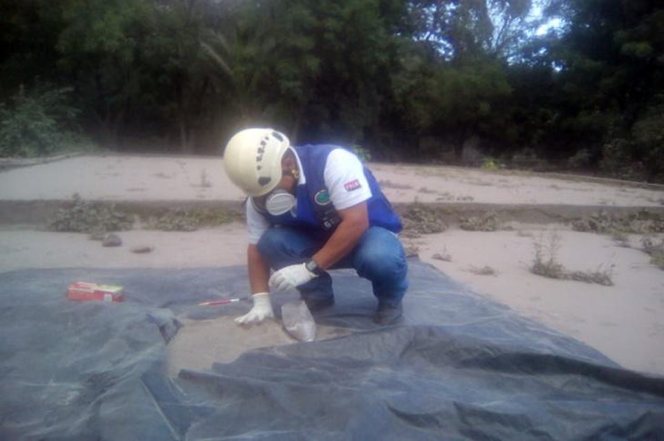 |
Figure 35. Ash was collected by INETER scientists from the 18 August 2017 explosion at San Cristóbal. Courtesy of INETER (Boletín mensual, Sismos y Volcanes de Nicaragua, Agosto, 2017). |
A small plume was noted in satellite imagery by the Washington VAAC on 18 August 2017 moving NW. Later imagery showed gas and ash drifting W at an estimated altitude of 2.1 km. It extended approximately 265 km W of the summit before dissipating. Ground measurements of SO2 made during 18-20 August showed increases to a peak of 3,519 metric tons per day on 19 August before dropping back to more typical background values below 700 t/d. INETER scientists used GOES and AVHRR satellite images to identify the maximum extent of the ash plume from the eruptive event. The ash cloud covered the area W of San Cristóbal, approximately 2,960 Km2, and extended more than 80 km offshore, with a total length of 125 km and a maximum width of 33 km (figure 36). Seismometers recorded 3,880 degassing-type seismic events during August 2017. Seismicity decreased slightly during September 2017 to 2,604 measured events, of which 2,415 were degassing-type, 187 were VT events, and two explosions were recorded on 1 September, but no ashfall was reported.
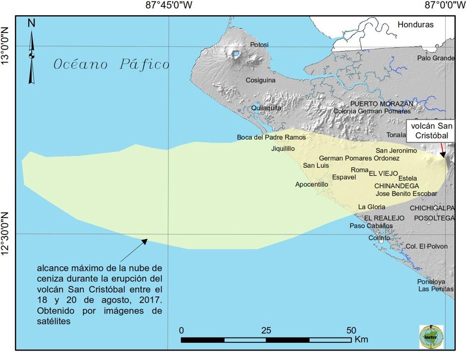 |
Figure 36. The extent of the ash plume from the 18-20 August 2017 eruptive episode at San Cristóbal, identified in satellite imagery by INETER scientists. Courtesy of INETER (Boletín mensual, Sismos y Volcanes de Nicaragua, Agosto, 2017). |
An order-of-magnitude increase in seismicity occurred during October-December 2017, with the monthly totals of the numbers of events ranging from 17,000-21,000 (figure 37). INETER reported a series of 14 explosions during the evening of 7 November. Ashfall was reported to the W in Los Farallones, San Agustín, La Mora, El Naranjo and the city of Chinandega. The Washington VAAC subsequently reported an ash plume that models suggested rose to 6.7 km and drifted W on 11 November.
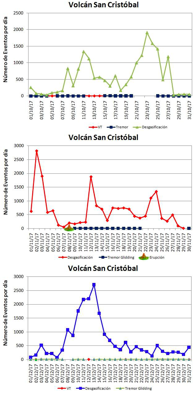 |
Figure 37. Numbers of daily seismic events at San Cristóbal during October-December 2017. Event types include VT (volcano-tectonic), degasification, and tremor. Note scale in each graph as different symbols and colors are used for the same type each month. Total seismic events for October (top) was 17,815, November (middle) was 19,206, and December (bottom) was 20,925. Ash bearing explosions were reported by INETER on 7 November, and the Washington VAAC reported an ash plume on 11 November that possibly rose to 6.7 km altitude and drifted W. Courtesy of INETER (Boletín mensual, Sismos y Volcanes de Nicaragua, Octubre, Noviembre, Diciembre, 2017). |
Information Contacts: Instituto Nicaragüense de Estudios Territoriales (INETER), Apartado Postal 2110, Managua, Nicaragua (URL: http://www.ineter.gob.ni/); Washington Volcanic Ash Advisory Center (VAAC), Satellite Analysis Branch (SAB), NOAA/NESDIS OSPO, NOAA Science Center Room 401, 5200 Auth Rd, Camp Springs, MD 20746, USA (URL: www.ospo.noaa.gov/Products/atmosphere/vaac, archive at: http://www.ssd.noaa.gov/VAAC/archive.html).
Moderate explosion on 22 April 2018
Activity at the San Cristobal volcano complex during 2017 was characterized by numerous weak ash-and-gas explosions, a succession of strong ash-and-gas explosion on 18 August, and thousands of degassing events (BGVN 43:03). This report covers January through July 2018.
According to the Instituto Nicaragüense de Estudios Territoriales (INETER), at 1320 on 22 April a moderate explosion generated an ash-and-gas plume that rose 500-800 m (figure 38), causing ashfall in the Comarca La Bolsa (8 km SW) and Hacienda Las Rojas (3 km WSW) and Loma Las Brujas (2 km W).
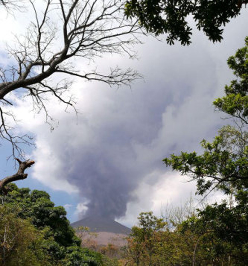 |
Figure 38. Photo of the gas-and-ash explosion at San Cristobal on 22 April 2018. Courtesy of Fausto Tijerino, INETER (Boletín mensual, Sismos y Volcanes de Nicaragua, Abril, 2018). |
INETER's April bulletin reported that the monthly averages of sulfur dioxide levels at San Cristobal during January through March 2018 ranged from 305-449 metric tons per day. On 22 April, the day of the explosion, levels reached 1903 tons. During the reporting period, MODIS satellite instruments using the MODVOLC algorithm recorded only two questionable thermal anomalies at San Cristobal. The MIROVA (Middle InfraRed Observation of Volcanic Activity) volcano hotspot detection system, also based on analysis of MODIS data, recorded numerous hotspots, but only one within 5 km of the volcano during January through July 2018. The latter one occurred during late March.
Information Contacts: Instituto Nicaragüense de Estudios Territoriales (INETER), Apartado Postal 2110, Managua, Nicaragua (URL: http://webserver2.ineter.gob.ni/vol/dep-vol.html); Hawai'i Institute of Geophysics and Planetology (HIGP) - MODVOLC Thermal Alerts System, School of Ocean and Earth Science and Technology (SOEST), Univ. of Hawai'i, 2525 Correa Road, Honolulu, HI 96822, USA (URL: http://modis.higp.hawaii.edu/); MIROVA (Middle InfraRed Observation of Volcanic Activity), a collaborative project between the Universities of Turin and Florence (Italy) supported by the Centre for Volcanic Risk of the Italian Civil Protection Department (URL: http://www.mirovaweb.it/).
Weak ash explosions in January and March 2019
San Cristóbal has produced occasional weak explosions since 1999, with intermittent gas-and-ash emissions. The only reported explosion during the first half of 2018 was on 22 April, the first since November 2017 (BGVN 43:03). The current report covers activity between 1 August 2018 and 1 May 2019. The volcano is monitored by the Instituto Nicaragüense de Estudios Territoriales (INETER).
According to INETER, a series of explosions occurred on 9 January 2019 that lasted several hours. INETER stated that one explosion occurred at 1643; the Washington VAAC's first advisory stated that an explosion occurred at 1145 (local time). The weak explosions, which occurred after a period of heightened seismic activity, generated an ash plume that reached 200 m above the edge of the crater and drifted W. The Washington VAAC reported volcanic ash plumes on 10-11 January extending about 92 km SW, and on 24-25 January extending about 185 km WSW. A low-energy explosion was detected by the seismic network at 1550 on 4 March 2019. The event produced a gas-and-ash plume that rose 400 m above the crater rim and drifted SW.
Monitoring data reported by INETER (table 6) showed elevated levels of seismicity during October 2018 through January 2019. Sulfur dioxide was also measured at higher levels in January 2019.
Table 6. Monthly sulfur dioxide measurements and seismicity reported at San Cristóbal during August 2018-March 2019. "Most" indicates that type of seismicity was dominant that month. Data courtesy of INETER.
| Month | Average SO2 | Total earthquakes | Degassing-type earthquakes | Volcano-tectonic (VT) earthquakes |
| Aug 2018 | 461 t/d | 6,464 | 6,147 | 251 |
| Sep 2018 | 893 t/d | 9,659 | 9,586 | 73 |
| Oct 2018 | 269 t/d | 11,698 | 3,509 | 8,189 |
| Nov 2018 | -- | 19,593 | 19,586 | 7 |
| Dec 2018 | -- | 30,901 | -- | Most |
| Jan 2019 | 1,286 t/d | 11,504 | Most | Very few |
| Feb 2019 | 695 t/d | 3,470 | Most | Very few |
| Mar 2019 | -- | 3,882 | Most | Very few |
Information Contacts: Instituto Nicaragüense de Estudios Territoriales (INETER), Apartado Postal 2110, Managua, Nicaragua (URL: http://webserver2.ineter.gob.ni/vol/dep-vol.html); Washington Volcanic Ash Advisory Center (VAAC), Satellite Analysis Branch (SAB), NOAA/NESDIS OSPO, NOAA Science Center Room 401, 5200 Auth Rd, Camp Springs, MD 20746, USA (URL: www.ospo.noaa.gov/Products/atmosphere/vaac, archive at: http://www.ssd.noaa.gov/VAAC/archive.html).
New eruption characterized by thermal anomalies, few explosions, and ash
San Cristóbal, located in Nicaragua, is a volcanic complex consisting of five edifices. Sporadic volcanism dates back to 1528, with frequent eruptions over the past 50 years. The previous eruption in March 2019 was characterized by weak ash explosions with intermittent gas-and-ash emissions (BGVN 44:04). This report updates activity from April 2019 through June 2021 and describes a new eruption beginning on 27 December 2020, when thermal anomaly was first identified. A later series of five explosions resulted in an ash plume and ashfall. Information comes from the Instituto Nicaragüense de Estudios Territoriales (INETER), the Sistema Nacional para la Prevencion, Mitigacion y Atencion de Desastres (SINAPRED), the Washington Volcanic Ash Advisory Center (VAAC), and various satellite data.
Activity during April 2019 through November 2020 was relatively calm and primarily consisted of gas-and-steam emissions and seismicity. Monitoring data reported by INETER consistently included the average sulfur dioxide levels (tons/day) and total number of earthquakes per month, a small number of which were volcano-tectonic events (table 7). Some landslides were noted in the inner part of the crater in the April 2019 monthly report.
Table 7. Monthly sulfur dioxide measurements and seismicity reported at San Cristóbal during April 2019-March 2021.
| Month | Average SO2 | Total earthquakes | Volcano-tectonic (VT) earthquakes |
| Apr 2019 | 251 t/d | 5,663 | -- |
| May 2019 | -- | 7,663 | -- |
| Jun 2019 | 440 t/d | 40,525 | -- |
| Jul 2019 | 340 t/d | 47,255 | -- |
| Aug 2019 | 323 t/d | 58,060 | -- |
| Sep 2019 | 323 t/d | 70,446 | -- |
| Oct 2019 | 515 t/d | 74,327 | -- |
| Nov 2019 | 404 t/d | 81,348 | -- |
| Dec 2019 | -- | 87,874 | -- |
| Jan 2020 | -- | 38,291 | -- |
| Feb 2020 | 263 t/d | 74,414 | -- |
| Mar 2020 | 141 t/d | 81,097 | -- |
| Apr 2020 | 172 t/d | 88,670 | -- |
| May 2020 | 151 t/d | 99,991 | -- |
| Jun 2020 | 187 t/d | 107,030 | 31 |
| Jul 2020 | 179 t/d | 121,076 | 31 |
| Aug 2020 | 259 t/d | 138,810 | 39 |
| Sep 2020 | 729 t/d | 149,333 | 78 |
| Oct 2020 | 215 t/d | 189,338 | 113 |
| Nov 2020 | 155 t/d | 214,078 | 126 |
| Dec 2020 | -- | 230,463 | 126 |
| Jan 2021 | 336 t/d | 15,221 | 2 |
| Feb 2021 | 317 t/d | 7,923 | 2 |
| Mar 2021 | 381 t/d | -- | -- |
| Apr 2021 | 374 t/d | 6,645 | 33 |
| May 2021 | 546 t/d | 6,273 | 4 |
| Jun 2021 | 934 t/d | 4,074 | 16 |
Starting in December 2020 and continuing through June 2021 intermittent thermal activity was recorded in the Sentinel-2 MODIS Thermal Volcanic Activity (figure 39). This data reflects the start of the new eruption in December, some of which was also observed in Sentinel-2 thermal satellite imagery in the summit crater on clear weather days. The start of the eruption was captured in satellite imagery on 27 December 2020 with two weak thermal anomalies in the crater (figure 40); additional intermittent anomalies were detected from different locations in the crater through June 2021.
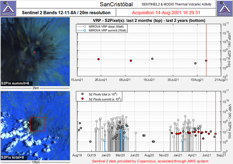 |
Figure 39. Sentinel-2 MODIS Thermal Volcanic Activity data (bands 12, 11, 8A) showing renewed thermal activity (red dots) at San Cristóbal in December 2020 that continues intermittently through June 2021. Initial activity marks the start of the new eruption that began in December. Courtesy of MIROVA. |
 |
Figure 40. Sentinel-2 thermal satellite imagery showing the start of a new eruptive episode at San Cristóbal with two faint thermal anomalies in the summit crater on 27 December 2020 (top left). A slightly stronger thermal anomaly was observed on clear weather days in the summit crater on 31 January (top right), 10 February (bottom left), 27 March (bottom right), 31 May (bottom left), and 25 June (bottom right) 2021. Images use “Atmospheric penetration” (bands 12, 11, 8A) rendering. Courtesy of Sentinel Hub Playground. |
INETER reported that at 1505 on 14 February 2021 a gas explosion produced a small ash emission. A Washington VAAC report noted that the ash cloud rose to 2.3 km altitude and drifted SW. Most of the ash was deposited on the slopes, some of which extended to Apastepe, Juan José Briceño, Las Nubes, Los Ébanos, Las Brisas, Versalles, Los Pellizcos, Valle de Los Morenos, and Los Chavarría. On 9 March SINAPRED reported that a series of five explosions were recorded during 1306-1332, the strongest of which occurred at 1325 and produced an ash plume that rose 800 m above the crater rim (figure 41). The Washington VAAC reported that the ash plume rose to 2.4 km altitude and drifted SW, though it was difficult to see in satellite imagery due to cloud cover. As a result, up to 2 mm of ashfall was reported in El Viejo (19 km WSW), Chinandega (16 km SW), and Chichigalapa (16 km S), as well as in other communities downwind including Las Grecias, La Mora, and La Bolsa. On 19 March a notable ash plume rose to 12.2 km altitude and drifted more than 80 km ENE, according to satellite data, ash dispersion models, and weather models.
 |
Figure 41. Photos of the explosion at San Cristóbal at 1326 on 9 March 2021 that generated an ash plume and rose up to 800 m above the crater (left) and ashfall in surrounding communities (right). Courtesy of SINAPRED. |
Information Contacts: Instituto Nicaragüense de Estudios Territoriales (INETER), Apartado Postal 2110, Managua, Nicaragua (URL: http://www.ineter.gob.ni/); Sistema Nacional para la Prevencion, Mitigacion y Atencion de Desastres (SINAPRED), Edificio SINAPRED, Rotonda Comandante Hugo Chávez 50 metros al Norte, frente a la Avenida Bolívar, Managua, Nicaragua (URL: http://www.sinapred.gob.ni/); Washington Volcanic Ash Advisory Center (VAAC), Satellite Analysis Branch (SAB), NOAA/NESDIS OSPO, NOAA Science Center Room 401, 5200 Auth Rd, Camp Springs, MD 20746, USA (URL: www.ospo.noaa.gov/Products/atmosphere/vaac, archive at: http://www.ssd.noaa.gov/VAAC/archive.html); MIROVA (Middle InfraRed Observation of Volcanic Activity), a collaborative project between the Universities of Turin and Florence (Italy) supported by the Centre for Volcanic Risk of the Italian Civil Protection Department (URL: http://www.mirovaweb.it/); Sentinel Hub Playground (URL: https://www.sentinel-hub.com/explore/sentinel-playground).
Explosions and ash plumes during December 2021
San Cristóbal is a volcanic complex located in Nicaragua that consists of five volcanic edifices; the youngest cone, San Cristóbal (also known as El Viejo), is capped by a 500 x 600 m-wide crater. Historical eruptions date back to 1528, with frequent eruptions occurring over the past 50 years. Recent activity has been characterized by thermal anomalies, occasional explosions, and ash plumes (BGVN 46:07). This report updates activity from July through December 2021 using information from the Instituto Nicaragüense de Estudios Territoriales (INETER) and various satellite data.
Activity during July through December 2021 was relatively calm and primarily consisted of gas-and-steam emissions and seismicity. Monitoring data reported by INETER consistently included the average sulfur dioxide levels (tons/day) and the total number of earthquakes per month, a small number of which were volcano-tectonic events (table 8). Tremor remained within 50 and 350 RSAM units.
Table 8. Monthly sulfur dioxide measurements and seismicity reported at San Cristóbal during July-December 2021.
| Month | Average SO2 | Total earthquakes | Volcano-tectonic (VT) earthquakes |
| Jul 2021 | 468 t/d | 113,791 | 11 |
| Aug 2021 | 443 t/d | 106,663 | 9 |
| Sep 2021 | 153 t/d | 105,603 | -- |
| Oct 2021 | 255 t/d | 104,230 | -- |
| Nov 2021 | 326 t/d | -- | -- |
| Dec 2021 | 603 t/d | -- | -- |
Temperature measurements using thermal images showed that gas-and-steam emissions in the crater were 40 °C in August, which was lower than the ~56 °C temperatures measured in July. A 40-m-long by 6-m-wide fracture was observed on the NW wall. Fumaroles persisted in the crater throughout the reporting period (figure 42). Little to no thermal activity was detected near the summit through December; a single weak anomaly was visible in MIROVA data during early October (figure 43). On clear weather days, a weak thermal anomaly was observed in the summit crater in Sentinel-2 infrared satellite imagery (figure 44).
A series of five low-to medium-intensity explosions were recorded between 0522 and 0526 on 15 December, according to INETER. Ash plumes rose 2.5 km above the crater rim and drifted W, resulting in ashfall in La Grecia, Rancherías (8 km NW), and El Viejo (18 km SW). Rocks were ejected 500 m from the vent onto the flanks.
 |
Figure 42. Photo of the crater at San Cristóbal taken in October 2021 showing gas-and-steam emissions. Courtesy of INETER (Sismos y Volcanes de Nicaragua. Octubre, 2021). |
 |
Figure 43. Low thermal activity was detected at the summit of San Cristóbal during July through December 2021; this MIROVA (Log Radiative Power) plot indicates only a single weak anomaly in early October. Courtesy of MIROVA. |
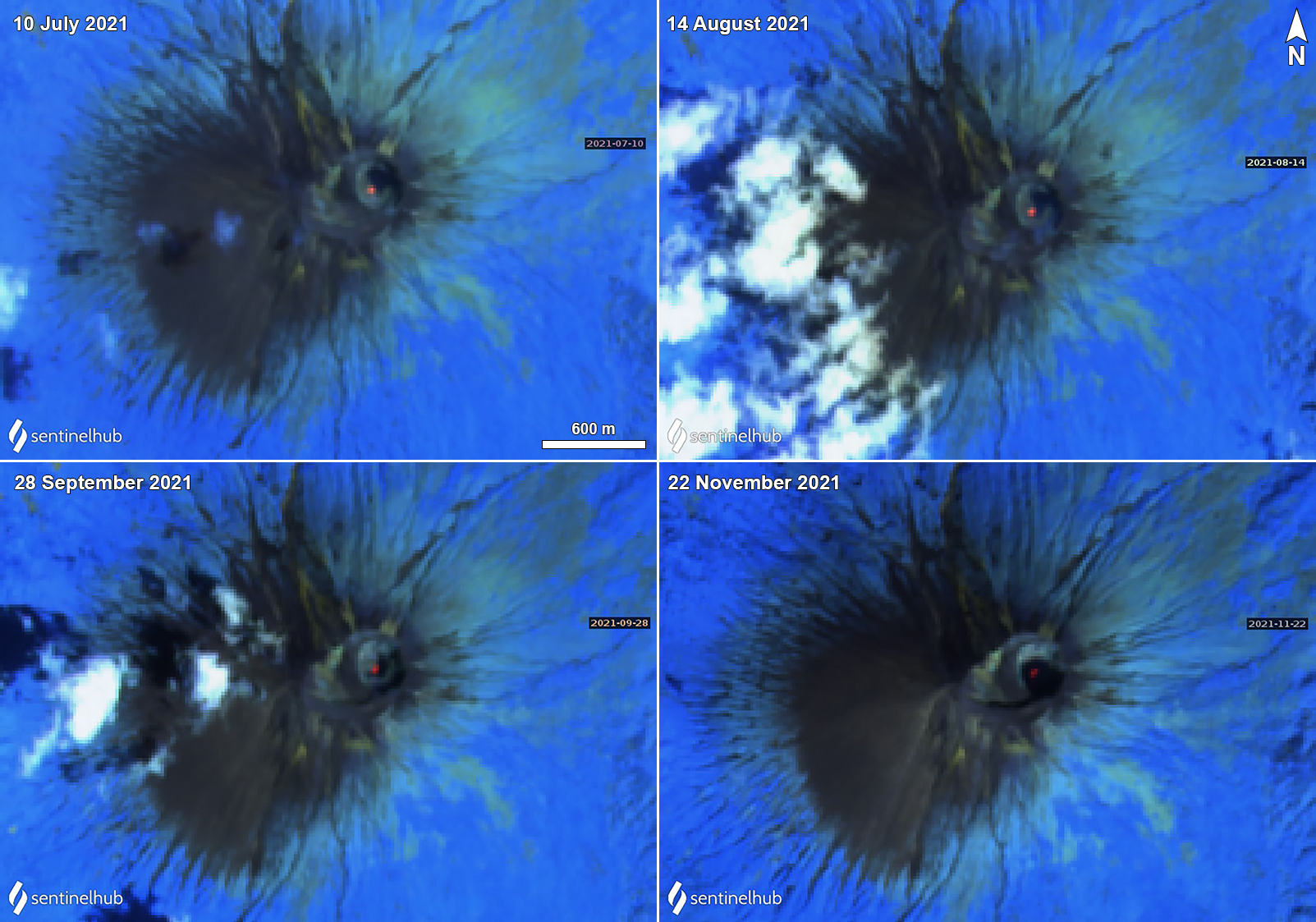 |
Figure 44. Sentinel-2 thermal satellite imagery showing a persistent, weak thermal anomaly (bright yellow-orange) at the summit crater of San Cristóbal on clear weather days on 10 July (top left), 14 August (top right), 28 September (bottom left), and 22 November (bottom right) 2021. Images use “Atmospheric penetration” (bands 12, 11, 8A) rendering. Courtesy of Sentinel Hub Playground. |
Information Contacts: Instituto Nicaragüense de Estudios Territoriales (INETER), Apartado Postal 2110, Managua, Nicaragua (URL: http://www.ineter.gob.ni/); MIROVA (Middle InfraRed Observation of Volcanic Activity), a collaborative project between the Universities of Turin and Florence (Italy) supported by the Centre for Volcanic Risk of the Italian Civil Protection Department (URL: http://www.mirovaweb.it/); Sentinel Hub Playground (URL: https://www.sentinel-hub.com/explore/sentinel-playground).
Small ash explosions and gas-and-steam emissions during January-June 2022
San Cristóbal, located in Nicaragua, is a volcanic complex that consists of five principal volcanic edifices forming the NW end of the Marrabios Range. The youngest cone, San Cristóbal (also known as El Viejo), is capped by a 500 x 600 m crater. Recorded eruptions date back to 1528, with more frequent eruptions occurring over the last 50 years. The current eruption period began in December 2020 and has recently been characterized by occasional low-to-medium intensity explosions, ash plumes, and low thermal activity (BGVN 47:01). This report covers activity through the end of the eruption during January through June 2022 using information from the Instituto Nicaragüense de Estudios Territoriales (INETER) and various satellite data.
Activity during January through August 2022 was relatively calm, according to INETER; gas-and-steam emissions and seismicity persisted throughout the reporting period (figure 45). Monitoring data reported by INETER consistently included the average sulfur dioxide levels (tons/day) and the total number of earthquakes per month, a small number of which were volcano-tectonic events (table 9). Tremor remained within 100-150 RSAM (Real-Time Seismic Amplitude Measurements), sometimes reaching up to 400 units.
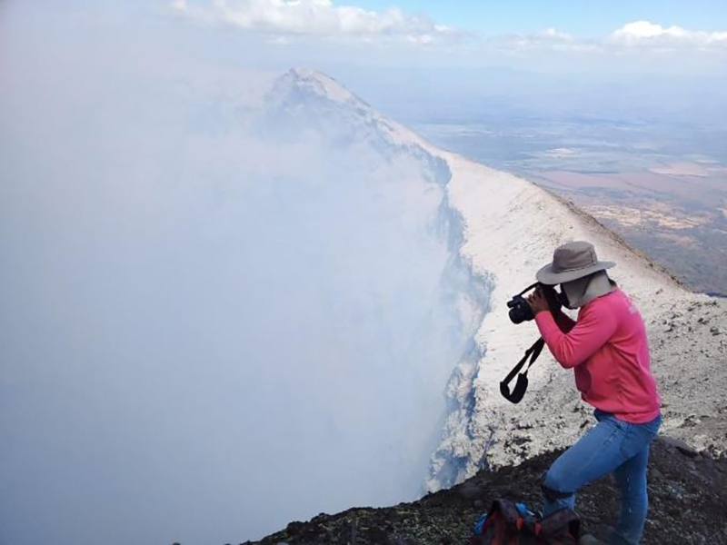 |
Figure 45. Photo from the summit crater rim of San Cristóbal showing persistent gas-and-steam emissions during February 2022. Courtesy of INETER (Boletín Sismos y Volcanes de Nicaragua. Febrero, 2022). |
Table 9. Monthly sulfur dioxide measurements and seismicity reported at San Cristóbal during January-August 2022. Courtesy of INETER.
| Month | Average SO2 | Total earthquakes | Volcano-tectonic (VT) earthquakes |
| Jan 2022 | -- | 4,965 | 0 |
| Feb 2022 | 266 t/d | 26,707 | 4 |
| Mar 2022 | 528 t/d | 15,344 | 14 |
| Apr 2022 | 360 t/d | 12,785 | 16 |
| May 2022 | 242 t/d | 24,267 | 9 |
| Jun 2022 | 725 t/d | 59,540 | 2 |
| Jul 2022 | 371 t/d | 32,647 | 11 |
| Aug 2022 | 958 t/d | 19,098 | 3 |
According to the MIROVA (Middle InfraRed Observation of Volcanic Activity) graph, only three instances of thermal hot spots were detected; once during early October 2021, once during early March 2022, and once during late April 2022. Small hotspots were visible at the summit crater during January through April 2022 in infrared satellite data from Sentinel-2 (figure 46).
 |
Figure 46. Sentinel-2 infrared satellite imagery showed a small thermal anomaly (bright yellow-orange) at San Cristóbal’s summit crater on 21 January 2022 (top left), 25 February (top right), 27 March (bottom left), and 16 April (bottom right). Occasional gas-and-steam emissions accompanied the thermal activity, as seen on 21 January, 27 March, and 16 April that drifted W. Images use “Atmospheric penetration” (bands 12, 11, 8A) rendering. Courtesy of Sentinel Hub Playground. |
On 10 February 2022 an increase in degassing-type earthquakes was noted, and five days later, on 15 February, the number of earthquakes dropped, coincident with several small gas-and-ash explosions. Temperature measurements using thermal images showed that gas-and-steam emissions from the southern wall of the crater were 59°C in February. On 3 March INETER reported several explosions. Throughout the rest of the month, activity was relatively low and consisted of 15,358 seismic events, 14 of which were volcano-tectonic. Continuous sulfur dioxide emissions were also recorded.
During April and May, INETER reported continued seismicity, registering 12,785 seismic events during April, 16 of which were volcano-tectonic. Low thermal activity was detected in infrared satellite data, and gas-and-steam emissions, including sulfur dioxide emissions, persisted. Similar low activity was reported during May, consisting mostly of 24,267 seismic events, 9 of which were volcano-tectonic, and sulfur dioxide emissions.
Relatively low activity continued during June, though seismicity remained at normal levels. There were 59,540 seismic events registered, two of which were volcano-tectonic. Sulfur dioxide emissions continued. According to a news article, INETER reported that at 0751 on 26 June a moderate explosion produced a gas-and-steam plume that rose 1.5 km above the crater rim and drifted WSW. A minor amount of ash fell in the communities of La Grecias 3 and Las Grecias 4 (12 km WSW), and the city of El Viejo (18 km WSW). RSAM data also spiked during the explosion and returned to normal levels after the event.
Information Contacts: Instituto Nicaragüense de Estudios Territoriales (INETER), Apartado Postal 2110, Managua, Nicaragua (URL: http://www.ineter.gob.ni/); MIROVA (Middle InfraRed Observation of Volcanic Activity), a collaborative project between the Universities of Turin and Florence (Italy) supported by the Centre for Volcanic Risk of the Italian Civil Protection Department (URL: http://www.mirovaweb.it/); Sentinel Hub Playground (URL: https://www.sentinel-hub.com/explore/sentinel-playground); Viva Nicaragua, Reparto El Carmen, Estatua Montoya 1C. Sur, 1C. Este, 50mts. Sur. Managua, Nicaragua (URL: https://www.vivanicaragua.com.ni/2022/06/26/sociales/volcan-san-cristobal-explosion-gases/).
Strong explosion with an ash plume, pyroclastic flows, and ashfall on 5 July 2023
San Cristóbal (also known as El Viejo), is located in Nicaragua and consists of five principal volcanic edifices that form the NW end of the Marrabios Range. Recorded eruptions date back to 1528, with more frequent eruptions occurring over the last 50 years. The most recent eruption period began in December 2020 and was characterized by small ash explosions and gas-and-steam emissions (BGVN 47:09). This report describes a short, one-day eruption on 5 July 2023, according to the Instituto Nicaragüense de Estudios Territoriales (INETER) and Sistema Nacional para la Prevención, Mitigación y Atención de Desastres (SINAPRED).
Activity during September 2022 through June 2023 was low, according to INETER; gas-and steam emissions and seismicity were still sometimes registered. Monitoring data reported by INETER consistently included the average sulfur dioxide levels (tons/day) and the total number of earthquakes per month, a small number of which were volcano-tectonic (VT) events (table 10). Tremor generally remained within 60-160 RSAM (Real-Time Seismic Amplitude Measurements); during June RSAM units were 60-1,200 and during 26 June through 5 July they were 200-400.
Table 10. Monthly sulfur dioxide measurements and seismicity reported at San Cristóbal during September 2022 through July 2023. Courtesy of INETER.
| Month | Average SO2 | Total earthquakes | Volcano-tectonic (VT) earthquakes |
| Sep 2022 | 334 t/d | -- | -- |
| Oct 2022 | 310 t/d | 4,260 | 260 |
| Nov 2022 | 432 t/d | 2,931 | 0 |
| Dec 2022 | -- | -- | -- |
| Jan 2023 | -- | -- | -- |
| Feb 2023 | -- | -- | 0 |
| Mar 2023 | 89 t/d | 6,319 | 0 |
| Apr 2023 | 63 t/d | 5,831 | 0 |
| May 2023 | 342 t/d | 6,978 | 0 |
| Jun 2023 | 479 t/d | 40,185 | 0 |
| Jul 2023 | 1,281 t/d | 17,964 | 0 |
Approximately 40,185 seismic events were recorded during June, with the RSAM units fluctuating between 60 up to 1,200. On 4 June, tremor increased and remained elevated until 8 June. Tremor declined to background levels until 21 June, when another increase was noted and remained elevated for several weeks.
During July the number of earthquakes decreased compared to June, with 17,964 registered. On 5 July at 1705 an explosion was reported that lasted a few minutes. A gas-and-ash plume rose 2 km above the crater and drifted SW and W (figure 47). Ashfall was reported in Las Grecías (12 km WSW), La Bolsa, and other smaller surrounding communities, according to data corroborated by the Risk Management unit of the Mayor’s Office of Chinandega. Pyroclastic flows were reported at the summit traveling 1 km, based on an analysis of Sentinel-3 images. The sulfur dioxide emissions rose as high as 1,281 t/d on 12 July, based on measurements using the Mobile DOAS technique. The eruption damaged crops and burned plants and grass in the area surrounding the volcano (figure 48). According to a Sentinel image captured on 9 July a narrow, dark deposit extended about 10 km W from the summit crater.
|
Figure 47. Photo of the ash plume rising 2 km above the crater at San Cristóbal that drifted SW and W on 5 July 2023 following an explosion. Pyroclastic flows were also visible near the summit of the volcano. Courtesy of SINAPRED. |
|
Figure 48. Photos of the ash plume that rose 2 km above the crater and resulting ashfall in Chinandega from the eruption on 5 July 2023 at San Cristóbal and the damage to vegetation around the volcano. Courtesy of the mayor of Chinandega and Fausto Tijeríno, INETER (Boletín Sismos y Volcanes de Nicaragua, Julio, 2023). |
Thermal activity was relatively low since June 2022; according to the MIROVA (Middle InfraRed Observation of Volcanic Activity) graph, four thermal anomalies were detected during March through June 2023 (figure 49). Infrared satellite images showed occasional small hotspots in the summit crater during April through July 2023 (figure 50).
|
Figure 49. Four thermal anomalies (red dots) were detected at San Cristóbal during March through June 2023, as recorded by the Landsat 8 and 9 satellite using OLI/SWIR bands 7, 6, 5. Courtesy of MIROVA. |
|
Figure 50. Infrared (bands B12, B11, B4) satellite imagery showed a weak thermal anomaly at the summit crater on 16 April 2023 (top left), 6 May 2023 (top middle), 15 June 2023 (top right), 25 June 2023 (bottom left), 30 June 2023 (bottom middle), and 5 July 2023 (bottom right). Courtesy of Copernicus Browser. |
Information Contacts: Instituto Nicaragüense de Estudios Territoriales (INETER), Apartado Postal 2110, Managua, Nicaragua (URL: http://www.ineter.gob.ni/); Sistema Nacional para la Prevencion, Mitigacion y Atencion de Desastres (SINAPRED), Edificio SINAPRED, Rotonda Comandante Hugo Chávez 50 metros al Norte, frente a la Avenida Bolívar, Managua, Nicaragua (URL: http://www.sinapred.gob.ni/); MIROVA (Middle InfraRed Observation of Volcanic Activity), a collaborative project between the Universities of Turin and Florence (Italy) supported by the Centre for Volcanic Risk of the Italian Civil Protection Department (URL: http://www.mirovaweb.it/); Copernicus Browser, Copernicus Data Space Ecosystem, European Space Agency (URL: https://dataspace.copernicus.eu/browser/).
|
|
||||||||||||||||||||||||||
There is data available for 35 confirmed Holocene eruptive periods.
2024 Jul 5 - 2024 Jul 7 Confirmed Eruption (Explosive / Effusive)
| Episode 1 | Eruption (Explosive / Effusive) | ||||
|---|---|---|---|---|
| 2024 Jul 5 - 2024 Jul 7 | Evidence from Observations: Reported | |||
2023 Jul 5 - 2023 Jul 5 Confirmed Eruption (Explosive / Effusive) VEI: 1
| Episode 1 | Eruption (Explosive / Effusive) | |||||||||||||||||||||||||
|---|---|---|---|---|---|---|---|---|---|---|---|---|---|---|---|---|---|---|---|---|---|---|---|---|---|
| 2023 Jul 5 - 2023 Jul 5 | Evidence from Observations: Reported | ||||||||||||||||||||||||
|
List of 3 Events for Episode 1
|
|||||||||||||||||||||||||
2020 Dec 27 (?) - 2022 Jun 26 Confirmed Eruption (Explosive / Effusive) VEI: 2
| Episode 1 | Eruption (Explosive / Effusive) | ||||||||||||||||||||||||||||||||||||||||
|---|---|---|---|---|---|---|---|---|---|---|---|---|---|---|---|---|---|---|---|---|---|---|---|---|---|---|---|---|---|---|---|---|---|---|---|---|---|---|---|---|
| 2020 Dec 27 (?) - 2022 Jun 26 | Evidence from Observations: Reported | |||||||||||||||||||||||||||||||||||||||
|
List of 6 Events for Episode 1
|
||||||||||||||||||||||||||||||||||||||||
2019 Mar 4 - 2019 Mar 4 Confirmed Eruption (Explosive / Effusive) VEI: 1
| Episode 1 | Eruption (Explosive / Effusive) | |||||||||||||||
|---|---|---|---|---|---|---|---|---|---|---|---|---|---|---|---|
| 2019 Mar 4 - 2019 Mar 4 | Evidence from Observations: Reported | ||||||||||||||
|
List of 1 Events for Episode 1
|
|||||||||||||||
2018 Apr 22 - 2018 Apr 22 Confirmed Eruption (Explosive / Effusive) VEI: 1
| Episode 1 | Eruption (Explosive / Effusive) | Summit crater | |||||||||||||||||||||||||||||||||||||||
|---|---|---|---|---|---|---|---|---|---|---|---|---|---|---|---|---|---|---|---|---|---|---|---|---|---|---|---|---|---|---|---|---|---|---|---|---|---|---|---|---|
| 2018 Apr 22 - 2018 Apr 22 | Evidence from Observations: Reported | |||||||||||||||||||||||||||||||||||||||
|
List of 6 Events for Episode 1 at Summit crater
|
||||||||||||||||||||||||||||||||||||||||
2017 Aug 18 - 2017 Nov 11 Confirmed Eruption (Explosive / Effusive) VEI: 2
| Episode 1 | Eruption (Explosive / Effusive) | Summit crater | |||||||||||||||||||||||||||||||||||||||||||||||||
|---|---|---|---|---|---|---|---|---|---|---|---|---|---|---|---|---|---|---|---|---|---|---|---|---|---|---|---|---|---|---|---|---|---|---|---|---|---|---|---|---|---|---|---|---|---|---|---|---|---|---|
| 2017 Aug 18 - 2017 Aug 19 | Evidence from Observations: Reported | |||||||||||||||||||||||||||||||||||||||||||||||||
|
List of 8 Events for Episode 1 at Summit crater
|
||||||||||||||||||||||||||||||||||||||||||||||||||
| Episode 2 | Eruption (Explosive / Effusive) | Summit crater | ||||||||||||||||||||||||||||||||||
|---|---|---|---|---|---|---|---|---|---|---|---|---|---|---|---|---|---|---|---|---|---|---|---|---|---|---|---|---|---|---|---|---|---|---|---|
| 2017 Nov 7 - 2017 Nov 11 | Evidence from Observations: Reported | ||||||||||||||||||||||||||||||||||
|
List of 5 Events for Episode 2 at Summit crater
|
|||||||||||||||||||||||||||||||||||
2017 Feb 18 - 2017 Apr 19 Confirmed Eruption (Explosive / Effusive) VEI: 1
| Episode 1 | Eruption (Explosive / Effusive) | Summit crater | ||||||||||||||||||||||||||||||||||||||||||||||||||||||||||||||||
|---|---|---|---|---|---|---|---|---|---|---|---|---|---|---|---|---|---|---|---|---|---|---|---|---|---|---|---|---|---|---|---|---|---|---|---|---|---|---|---|---|---|---|---|---|---|---|---|---|---|---|---|---|---|---|---|---|---|---|---|---|---|---|---|---|---|
| 2017 Feb 18 - 2017 Apr 19 | Evidence from Observations: Reported | ||||||||||||||||||||||||||||||||||||||||||||||||||||||||||||||||
|
List of 11 Events for Episode 1 at Summit crater
|
|||||||||||||||||||||||||||||||||||||||||||||||||||||||||||||||||
2016 Apr 22 - 2016 Apr 22 Confirmed Eruption (Explosive / Effusive) VEI: 2
| Episode 1 | Eruption (Explosive / Effusive) | Summit crater | ||||||||||||||||||||||||||||||||||
|---|---|---|---|---|---|---|---|---|---|---|---|---|---|---|---|---|---|---|---|---|---|---|---|---|---|---|---|---|---|---|---|---|---|---|---|
| 2016 Apr 22 - 2016 Apr 22 | Evidence from Observations: Reported | ||||||||||||||||||||||||||||||||||
|
List of 5 Events for Episode 1 at Summit crater
|
|||||||||||||||||||||||||||||||||||
2015 Mar 5 - 2015 Jun 12 Confirmed Eruption (Explosive / Effusive) VEI: 2
| Episode 1 | Eruption (Explosive / Effusive) | Summit crater | |||||||||||||||||||||||||||||
|---|---|---|---|---|---|---|---|---|---|---|---|---|---|---|---|---|---|---|---|---|---|---|---|---|---|---|---|---|---|---|
| 2015 Mar 5 - 2015 Mar 5 | Evidence from Observations: Reported | |||||||||||||||||||||||||||||
|
List of 4 Events for Episode 1 at Summit crater
|
||||||||||||||||||||||||||||||
| Episode 2 | Eruption (Explosive / Effusive) | Summit crater | ||||||||||||||||||||||||||||||||||||||||||||
|---|---|---|---|---|---|---|---|---|---|---|---|---|---|---|---|---|---|---|---|---|---|---|---|---|---|---|---|---|---|---|---|---|---|---|---|---|---|---|---|---|---|---|---|---|---|
| 2015 Jun 6 - 2015 Jun 12 | Evidence from Observations: Reported | ||||||||||||||||||||||||||||||||||||||||||||
|
List of 7 Events for Episode 2 at Summit crater
|
|||||||||||||||||||||||||||||||||||||||||||||
2014 Jul 20 - 2014 Oct 1 Confirmed Eruption (Explosive / Effusive) VEI: 2
| Episode 1 | Eruption (Explosive / Effusive) | Summit crater | ||||||||||||||||||||||||||||||||||||||||||||||||||||||
|---|---|---|---|---|---|---|---|---|---|---|---|---|---|---|---|---|---|---|---|---|---|---|---|---|---|---|---|---|---|---|---|---|---|---|---|---|---|---|---|---|---|---|---|---|---|---|---|---|---|---|---|---|---|---|---|
| 2014 Jul 20 - 2014 Oct 1 | Evidence from Observations: Reported | ||||||||||||||||||||||||||||||||||||||||||||||||||||||
|
List of 9 Events for Episode 1 at Summit crater
|
|||||||||||||||||||||||||||||||||||||||||||||||||||||||
2014 Feb 4 - 2014 Apr 12 Confirmed Eruption (Explosive / Effusive) VEI: 1
| Episode 1 | Eruption (Explosive / Effusive) | Summit crater | |||||||||||||||||||||||||||||||||||||||
|---|---|---|---|---|---|---|---|---|---|---|---|---|---|---|---|---|---|---|---|---|---|---|---|---|---|---|---|---|---|---|---|---|---|---|---|---|---|---|---|---|
| 2014 Feb 4 - 2014 Apr 12 | Evidence from Observations: Reported | |||||||||||||||||||||||||||||||||||||||
|
List of 6 Events for Episode 1 at Summit crater
|
||||||||||||||||||||||||||||||||||||||||
2013 Jun 7 - 2013 Jun 7 Confirmed Eruption (Explosive / Effusive) VEI: 1
| Episode 1 | Eruption (Explosive / Effusive) | Summit crater | |||||||||||||||||||||||||||||
|---|---|---|---|---|---|---|---|---|---|---|---|---|---|---|---|---|---|---|---|---|---|---|---|---|---|---|---|---|---|---|
| 2013 Jun 7 - 2013 Jun 7 | Evidence from Observations: Reported | |||||||||||||||||||||||||||||
|
List of 4 Events for Episode 1 at Summit crater
|
||||||||||||||||||||||||||||||
2012 Dec 26 - 2012 Dec 28 Confirmed Eruption (Explosive / Effusive) VEI: 2
| Episode 1 | Eruption (Explosive / Effusive) | Summit crater | |||||||||||||||||||||||||||||||||||||||||||||||||||||||||||||||||||||||||||||||
|---|---|---|---|---|---|---|---|---|---|---|---|---|---|---|---|---|---|---|---|---|---|---|---|---|---|---|---|---|---|---|---|---|---|---|---|---|---|---|---|---|---|---|---|---|---|---|---|---|---|---|---|---|---|---|---|---|---|---|---|---|---|---|---|---|---|---|---|---|---|---|---|---|---|---|---|---|---|---|---|---|
| 2012 Dec 26 - 2012 Dec 28 | Evidence from Observations: Reported | |||||||||||||||||||||||||||||||||||||||||||||||||||||||||||||||||||||||||||||||
|
List of 14 Events for Episode 1 at Summit crater
|
||||||||||||||||||||||||||||||||||||||||||||||||||||||||||||||||||||||||||||||||
2012 Sep 8 - 2012 Sep 15 Confirmed Eruption (Explosive / Effusive) VEI: 2
| Episode 1 | Eruption (Explosive / Effusive) | Summit crater | ||||||||||||||||||||||||||||||||||||||||||||||||||||||||||||||||||||||||||
|---|---|---|---|---|---|---|---|---|---|---|---|---|---|---|---|---|---|---|---|---|---|---|---|---|---|---|---|---|---|---|---|---|---|---|---|---|---|---|---|---|---|---|---|---|---|---|---|---|---|---|---|---|---|---|---|---|---|---|---|---|---|---|---|---|---|---|---|---|---|---|---|---|---|---|---|
| 2012 Sep 8 - 2012 Sep 15 | Evidence from Observations: Reported | ||||||||||||||||||||||||||||||||||||||||||||||||||||||||||||||||||||||||||
|
List of 13 Events for Episode 1 at Summit crater
|
|||||||||||||||||||||||||||||||||||||||||||||||||||||||||||||||||||||||||||
2011 Aug 21 (?) - 2011 Oct 23 Confirmed Eruption (Explosive / Effusive) VEI: 1
| Episode 1 | Eruption (Explosive / Effusive) | Summit crater | ||||||||||||||||||||||||||||||||||
|---|---|---|---|---|---|---|---|---|---|---|---|---|---|---|---|---|---|---|---|---|---|---|---|---|---|---|---|---|---|---|---|---|---|---|---|
| 2011 Aug 21 (?) - 2011 Oct 23 | Evidence from Observations: Reported | ||||||||||||||||||||||||||||||||||
|
List of 5 Events for Episode 1 at Summit crater
|
|||||||||||||||||||||||||||||||||||
2010 Jun 9 - 2011 Jan 13 Confirmed Eruption (Explosive / Effusive) VEI: 2
| Episode 1 | Eruption (Explosive / Effusive) | Summit crater | ||||||||||||||||||||||||||||||||||||||||||||||||||||||||||||||||
|---|---|---|---|---|---|---|---|---|---|---|---|---|---|---|---|---|---|---|---|---|---|---|---|---|---|---|---|---|---|---|---|---|---|---|---|---|---|---|---|---|---|---|---|---|---|---|---|---|---|---|---|---|---|---|---|---|---|---|---|---|---|---|---|---|---|
| 2010 Jun 9 - 2010 Sep 21 | Evidence from Observations: Reported | ||||||||||||||||||||||||||||||||||||||||||||||||||||||||||||||||
|
List of 11 Events for Episode 1 at Summit crater
|
|||||||||||||||||||||||||||||||||||||||||||||||||||||||||||||||||
| Episode 2 | Eruption (Explosive / Effusive) | Summit crater | |||||||||||||||||||||||||||||||||||||||||||||||||
|---|---|---|---|---|---|---|---|---|---|---|---|---|---|---|---|---|---|---|---|---|---|---|---|---|---|---|---|---|---|---|---|---|---|---|---|---|---|---|---|---|---|---|---|---|---|---|---|---|---|---|
| 2010 Dec 13 - 2011 Jan 13 | Evidence from Observations: Reported | |||||||||||||||||||||||||||||||||||||||||||||||||
|
List of 8 Events for Episode 2 at Summit crater
|
||||||||||||||||||||||||||||||||||||||||||||||||||
2009 Sep 6 - 2009 Dec 26 (?) Confirmed Eruption (Explosive / Effusive) VEI: 2 (?)
| Episode 1 | Eruption (Explosive / Effusive) | ||||||||||||||||||||||||||||||
|---|---|---|---|---|---|---|---|---|---|---|---|---|---|---|---|---|---|---|---|---|---|---|---|---|---|---|---|---|---|---|
| 2009 Sep 6 - 2009 Dec 26 (?) | Evidence from Observations: Reported | |||||||||||||||||||||||||||||
|
List of 4 Events for Episode 1
|
||||||||||||||||||||||||||||||
2008 Nov 21 - 2008 Nov 21 Confirmed Eruption (Explosive / Effusive) VEI: 1
| Episode 1 | Eruption (Explosive / Effusive) | |||||||||||||||||||||||||||||||||||
|---|---|---|---|---|---|---|---|---|---|---|---|---|---|---|---|---|---|---|---|---|---|---|---|---|---|---|---|---|---|---|---|---|---|---|---|
| 2008 Nov 21 - 2008 Nov 21 | Evidence from Observations: Reported | ||||||||||||||||||||||||||||||||||
|
List of 5 Events for Episode 1
|
|||||||||||||||||||||||||||||||||||
2008 Jun 22 - 2008 Aug 5 ± 4 days Confirmed Eruption (Explosive / Effusive) VEI: 1
| Episode 1 | Eruption (Explosive / Effusive) | |||||||||||||||||||||||||||||||||||
|---|---|---|---|---|---|---|---|---|---|---|---|---|---|---|---|---|---|---|---|---|---|---|---|---|---|---|---|---|---|---|---|---|---|---|---|
| 2008 Jun 22 - 2008 Aug 5 ± 4 days | Evidence from Observations: Reported | ||||||||||||||||||||||||||||||||||
|
List of 5 Events for Episode 1
|
|||||||||||||||||||||||||||||||||||
2007 Nov 8 (on or before) Confirmed Eruption (Explosive / Effusive) VEI: 1 (?)
| Episode 1 | Eruption (Explosive / Effusive) | ||||||||||||||||||||||||||||||
|---|---|---|---|---|---|---|---|---|---|---|---|---|---|---|---|---|---|---|---|---|---|---|---|---|---|---|---|---|---|---|
| 2007 Nov 8 (on or before) - Unknown | Evidence from Observations: Reported | |||||||||||||||||||||||||||||
|
List of 4 Events for Episode 1
|
||||||||||||||||||||||||||||||
2005 Nov 13 - 2006 May 27 Confirmed Eruption (Explosive / Effusive) VEI: 2
| Episode 1 | Eruption (Explosive / Effusive) | |||||||||||||||||||||||||||||||||||||||||||||
|---|---|---|---|---|---|---|---|---|---|---|---|---|---|---|---|---|---|---|---|---|---|---|---|---|---|---|---|---|---|---|---|---|---|---|---|---|---|---|---|---|---|---|---|---|---|
| 2005 Nov 13 - 2006 May 27 | Evidence from Observations: Reported | ||||||||||||||||||||||||||||||||||||||||||||
|
List of 7 Events for Episode 1
|
|||||||||||||||||||||||||||||||||||||||||||||
2004 Dec 3 - 2004 Dec 7 Confirmed Eruption (Explosive / Effusive) VEI: 1
| Episode 1 | Eruption (Explosive / Effusive) | ||||||||||||||||||||||||||||||
|---|---|---|---|---|---|---|---|---|---|---|---|---|---|---|---|---|---|---|---|---|---|---|---|---|---|---|---|---|---|---|
| 2004 Dec 3 - 2004 Dec 7 | Evidence from Observations: Reported | |||||||||||||||||||||||||||||
|
List of 4 Events for Episode 1
|
||||||||||||||||||||||||||||||
2003 Jun 17 - 2004 Jun 13 Confirmed Eruption (Explosive / Effusive) VEI: 1 (?)
| Episode 1 | Eruption (Explosive / Effusive) | ||||||||||||||||||||||||||||||||||||||||
|---|---|---|---|---|---|---|---|---|---|---|---|---|---|---|---|---|---|---|---|---|---|---|---|---|---|---|---|---|---|---|---|---|---|---|---|---|---|---|---|---|
| 2003 Jun 17 - 2004 Jun 13 | Evidence from Observations: Reported | |||||||||||||||||||||||||||||||||||||||
|
List of 6 Events for Episode 1
|
||||||||||||||||||||||||||||||||||||||||
2002 May 29 - 2002 Dec 16 (?) Confirmed Eruption (Explosive / Effusive) VEI: 1
| Episode 1 | Eruption (Explosive / Effusive) | |||||||||||||||||||||||||||||||||||||||||||||
|---|---|---|---|---|---|---|---|---|---|---|---|---|---|---|---|---|---|---|---|---|---|---|---|---|---|---|---|---|---|---|---|---|---|---|---|---|---|---|---|---|---|---|---|---|---|
| 2002 May 29 - 2002 Dec 16 (?) | Evidence from Observations: Reported | ||||||||||||||||||||||||||||||||||||||||||||
|
List of 7 Events for Episode 1
|
|||||||||||||||||||||||||||||||||||||||||||||
2001 May 11 (?) - 2001 Dec 9 (?) Confirmed Eruption (Explosive / Effusive) VEI: 1
| Episode 1 | Eruption (Explosive / Effusive) | |||||||||||||||||||||||||||||||||||
|---|---|---|---|---|---|---|---|---|---|---|---|---|---|---|---|---|---|---|---|---|---|---|---|---|---|---|---|---|---|---|---|---|---|---|---|
| 2001 May 11 (?) - 2001 Dec 9 (?) | Evidence from Observations: Reported | ||||||||||||||||||||||||||||||||||
|
List of 5 Events for Episode 1
|
|||||||||||||||||||||||||||||||||||
1999 May 1 ± 180 days - 2000 Jun 16 ± 15 days Confirmed Eruption (Explosive / Effusive) VEI: 2
| Episode 1 | Eruption (Explosive / Effusive) | |||||||||||||||||||||||||||||||||||||||||||||||||||||||||||||||||
|---|---|---|---|---|---|---|---|---|---|---|---|---|---|---|---|---|---|---|---|---|---|---|---|---|---|---|---|---|---|---|---|---|---|---|---|---|---|---|---|---|---|---|---|---|---|---|---|---|---|---|---|---|---|---|---|---|---|---|---|---|---|---|---|---|---|
| 1999 May 1 ± 180 days - 2000 Jun 16 ± 15 days | Evidence from Observations: Reported | ||||||||||||||||||||||||||||||||||||||||||||||||||||||||||||||||
|
List of 11 Events for Episode 1
|
|||||||||||||||||||||||||||||||||||||||||||||||||||||||||||||||||
1997 May 19 (?) - 1997 Jul 7 (on or after) Confirmed Eruption (Explosive / Effusive) VEI: 1
| Episode 1 | Eruption (Explosive / Effusive) | |||||||||||||||||||||||||||||||||||
|---|---|---|---|---|---|---|---|---|---|---|---|---|---|---|---|---|---|---|---|---|---|---|---|---|---|---|---|---|---|---|---|---|---|---|---|
| 1997 May 19 (?) - 1997 Jul 7 (on or after) | Evidence from Observations: Reported | ||||||||||||||||||||||||||||||||||
|
List of 5 Events for Episode 1
|
|||||||||||||||||||||||||||||||||||
[ 1987 Nov 16 ± 15 days ] Uncertain Eruption
| Episode 1 | Eruption (Explosive / Effusive) | |||||||||||||||
|---|---|---|---|---|---|---|---|---|---|---|---|---|---|---|---|
| 1987 Nov 16 ± 15 days - Unknown | Evidence from Unknown | ||||||||||||||
| A small ash eruption may have taken place in November 1987 (SEAN 13:01). | |||||||||||||||
|
List of 1 Events for Episode 1
|
|||||||||||||||
[ 1985 Sep 2 ] Uncertain Eruption
| Episode 1 | Eruption (Explosive / Effusive) | |||||||||||||||
|---|---|---|---|---|---|---|---|---|---|---|---|---|---|---|---|
| 1985 Sep 2 - Unknown | Evidence from Unknown | ||||||||||||||
| A whitish, rather wispy plume about 70 km long was sighted over San Cristobal by astronauts on the Space Shuttle. Vigorous gas plumes have been reported by ground observers several times in the past few years (SEAN). | |||||||||||||||
|
List of 1 Events for Episode 1
|
|||||||||||||||
1977 Oct 16 - 1977 Oct 16 Confirmed Eruption (Explosive / Effusive) VEI: 2
| Episode 1 | Eruption (Explosive / Effusive) | |||||||||||||||||||||||||
|---|---|---|---|---|---|---|---|---|---|---|---|---|---|---|---|---|---|---|---|---|---|---|---|---|---|
| 1977 Oct 16 - 1977 Oct 16 | Evidence from Observations: Reported | ||||||||||||||||||||||||
|
List of 3 Events for Episode 1
|
|||||||||||||||||||||||||
1976 Aug 29 - 1976 Aug 29 Confirmed Eruption (Explosive / Effusive) VEI: 1
| Episode 1 | Eruption (Explosive / Effusive) | |||||||||||||||||||||||||
|---|---|---|---|---|---|---|---|---|---|---|---|---|---|---|---|---|---|---|---|---|---|---|---|---|---|
| 1976 Aug 29 - 1976 Aug 29 | Evidence from Observations: Reported | ||||||||||||||||||||||||
|
List of 3 Events for Episode 1
|
|||||||||||||||||||||||||
1976 Mar 9 - 1976 Mar 16 Confirmed Eruption (Explosive / Effusive) VEI: 1
| Episode 1 | Eruption (Explosive / Effusive) | |||||||||||||||||||||||||||||||||||
|---|---|---|---|---|---|---|---|---|---|---|---|---|---|---|---|---|---|---|---|---|---|---|---|---|---|---|---|---|---|---|---|---|---|---|---|
| 1976 Mar 9 - 1976 Mar 16 | Evidence from Observations: Reported | ||||||||||||||||||||||||||||||||||
|
List of 5 Events for Episode 1
|
|||||||||||||||||||||||||||||||||||
1971 May 3 - 1971 Jul 5 ± 4 days Confirmed Eruption (Explosive / Effusive) VEI: 1
| Episode 1 | Eruption (Explosive / Effusive) | |||||||||||||||||||||||||
|---|---|---|---|---|---|---|---|---|---|---|---|---|---|---|---|---|---|---|---|---|---|---|---|---|---|
| 1971 May 3 - 1971 Jul 5 ± 4 days | Evidence from Observations: Reported | ||||||||||||||||||||||||
|
List of 3 Events for Episode 1
|
|||||||||||||||||||||||||
1685 Aug Confirmed Eruption (Explosive / Effusive) VEI: 2
| Episode 1 | Eruption (Explosive / Effusive) | ||||||||||||||||||||
|---|---|---|---|---|---|---|---|---|---|---|---|---|---|---|---|---|---|---|---|---|
| 1685 Aug - Unknown | Evidence from Observations: Reported | |||||||||||||||||||
|
List of 2 Events for Episode 1
|
||||||||||||||||||||
1684 Jul Confirmed Eruption (Explosive / Effusive) VEI: 2
| Episode 1 | Eruption (Explosive / Effusive) | |||||||||||||||||||||||||
|---|---|---|---|---|---|---|---|---|---|---|---|---|---|---|---|---|---|---|---|---|---|---|---|---|---|
| 1684 Jul - Unknown | Evidence from Observations: Reported | ||||||||||||||||||||||||
|
List of 3 Events for Episode 1
|
|||||||||||||||||||||||||
1680 Confirmed Eruption (Explosive / Effusive) VEI: 2 (?)
| Episode 1 | Eruption (Explosive / Effusive) | |||||||||||||||||||||||||
|---|---|---|---|---|---|---|---|---|---|---|---|---|---|---|---|---|---|---|---|---|---|---|---|---|---|
| 1680 - Unknown | Evidence from Observations: Reported | ||||||||||||||||||||||||
|
List of 3 Events for Episode 1
|
|||||||||||||||||||||||||
[ 1613 ] Uncertain Eruption
| Episode 1 | Eruption (Explosive / Effusive) | ||||||||||||||||||||
|---|---|---|---|---|---|---|---|---|---|---|---|---|---|---|---|---|---|---|---|---|
| 1613 - Unknown | Evidence from Unknown | |||||||||||||||||||
| The Spanish friar Vazques de Espinosa found the volcano "smoking" when he visited Nicaragua in 1613 (Incer, 1988 unpub. manuscript). | ||||||||||||||||||||
|
List of 2 Events for Episode 1
|
||||||||||||||||||||
1528 ± 1 years Confirmed Eruption (Explosive / Effusive) VEI: 3
| Episode 1 | Eruption (Explosive / Effusive) | |||||||||||||||||||||||||
|---|---|---|---|---|---|---|---|---|---|---|---|---|---|---|---|---|---|---|---|---|---|---|---|---|---|
| 1528 ± 1 years - Unknown | Evidence from Observations: Reported | ||||||||||||||||||||||||
| The Spanish chronicler Oviedo, who lived in Nicaragua from 1527 to 1529, reported that three volcanoes in the Maribios Range were active, producing fumes that destroyed crops (Incer, 1988 unpub. manuscript). This apparently is the same report that the CAVW attributes to the early 1520s, when the volcano was first seen by the Spaniards. The Spanish conquest of Nicaragua was in 1524, however, and the first Spanish report of Nicaraguan eruptions was in 1525. The CAVW reports that San Cristobal was very active and emitted "flames" at the time, and was continually active in 16th century. Much of this activity was probably fumarolic activity (Hazlett, 1987). Reports of 16th century eruptions at Casita at the east end of the San Cristobal complex are not certain and may refer to other Maribios Range volcanoes (Incer, 1988 unpub. manuscript). | |||||||||||||||||||||||||
|
List of 3 Events for Episode 1
|
|||||||||||||||||||||||||
This compilation of synonyms and subsidiary features may not be comprehensive. Features are organized into four major categories: Cones, Craters, Domes, and Thermal Features. Synonyms of features appear indented below the primary name. In some cases additional feature type, elevation, or location details are provided.
Synonyms |
||||
| Viejo, El | Chinendega | Chinandega | ||||
Cones |
||||
| Feature Name | Feature Type | Elevation | Latitude | Longitude |
| Apastepe, Loma | Pyroclastic cone | 12° 43' 55.00" N | 87° 3' 40.00" W | |
| Casita
Chichigalpa Santa Clara |
Stratovolcano | 1405 m | 12° 41' 17.00" N | 86° 57' 25.00" W |
| Chonco, Volcán el
Choncle Chonce, El |
Stratovolcano | 1105 m | 12° 42' 11.00" N | 87° 2' 38.00" W |
| Moyotepe, Cerro
Mayotepe, Cerro |
Stratovolcano | 917 m | 12° 44' 28.00" N | 86° 59' 2.00" W |
| Ojo de Agua, Loma | Pyroclastic cone | 12° 41' 6.00" N | 86° 51' 22.00" W | |
| San Isidro, Loma | Cone | 12° 41' 20.00" N | 86° 50' 49.00" W | |
| San Lucas, Loma | Cone | 12° 41' 13.00" N | 86° 51' 47.00" W | |
| Talolinga, Loma | Pyroclastic cone | 80 m | 12° 42' 0.00" N | 86° 50' 2.00" W |
Craters |
||||
| Feature Name | Feature Type | Elevation | Latitude | Longitude |
| Agua, Laguna de | Crater | 12° 46' 55.00" N | 87° 0' 29.00" W | |
| Hoya, La | Crater | 12° 35' 31.00" N | 86° 55' 16.00" W | |
| Hoyada, La | Crater | 12° 35' 46.00" N | 86° 55' 26.00" W | |
| Ollada, La | Crater | 1405 m | 12° 41' 17.00" N | 86° 57' 25.00" W |
| Pelona, Loma la | Caldera | 827 m | 12° 41' 0.00" N | 86° 56' 0.00" W |
| Seca, Laguna | Crater | 12° 46' 23.00" N | 87° 0' 25.00" W | |
Domes |
||||
| Feature Name | Feature Type | Elevation | Latitude | Longitude |
| Bruja, Loma la | Dome | 12° 43' 0.00" N | 87° 1' 0.00" W | |
| Caparra, Loma | Dome | 540 m | 12° 43' 8.00" N | 87° 2' 17.00" W |
| Teta, Loma la | Dome | 640 m | 12° 42' 14.00" N | 87° 3' 25.00" W |
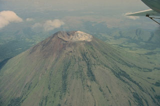 San Cristóbal, seen in this 1975 aerial view from the south, is the highest volcano in the Marrabios Range of western Nicaragua. The symmetrical, 1745-m-high stratovolcano is the youngest of five principal volcanoes forming the San Cristóbal complex. Young lava flows are located on its SW and northern flanks. Explosive eruptions have occurred since the beginning of the Spanish era. Cerro Moyotepe, a small composite volcano of the San Cristóbal complex that is cut by a series of N-S faults, appears at the right, below the plane wing.
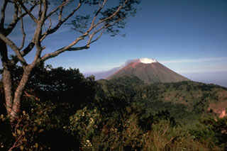 Steaming San Cristóbal volcano rises to the WNW beyond the rim of La Ollada, the 1-km-wide crater of Casita volcano. Fumarole activity along the northern wall of La Ollada has persisted since the early 16th century and does not exceed a temperature of 100 degrees Centigrade. This photo was taken from the summit of Casita volcano.
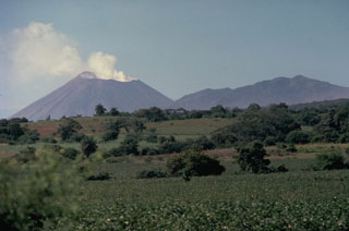 The San Cristóbal volcanic complex towers above the Plain of León to its south. A vigorous steam plume rises in 1978 above San Cristóbal (El Viejo) volcano at the left, the most recently active volcano of the complex. The irregular summit of Casita volcano (right) was formed by eruptions from several independent, partially overlapping craters along an E-W axis. Seven fumarolic areas are widely scattered over Casita volcano, which is also known as Chichigalpa.
 San Cristóbal volcano, one of the most dramatic landmarks in Nicaragua, rises to 1745 m above cotton fields on its southern flank. This 1975 view of the volcano, also known as El Viejo, shows a strong gas plume drifting down its western flank. Persistent fuming has released large amounts of sulfur dioxide, destroying forests on this side of the volcano; the gas plume was strong enough to corrode barbed wire. Lava flows and explosive activity have occurred from lateral vents as well as from the large summit crater.
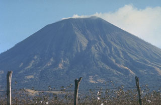 The less-often seen gullied northern flanks of San Cristóbal volcano rise above cotton fields at its base. San Cristóbal is a relatively recent name derived from a coffee plantation on its western flank; the volcano was previously known as El Viejo or Chinandega. It was used as a lighthouse for navigation by the British buccaneer Dampier when he sailed into the Bay of Corinto in July 1684. The following August he returned to the bay, but observed only smoking, rather than the "flames" he reported the previous year.
 The San Cristóbal volcanic complex consists of five principal edifices. The youngest cone, the namesake San Cristóbal, seen here from the south, is the highest peak of the Marrabios Range. Several radial flank craters occur along a N-S line on the outer north flank of 1745-m-high San Cristóbal. Historical activity, consisting of small-to-moderate explosive eruptions, has been reported since the 16th century. The SW crater rim (left) rises 140 m above the NE rim because prevailing trade winds distribute tephra to the SW.
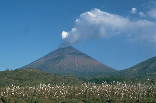 A strong steam plume pours from the summit crater of San Cristóbal volcano in this March 1976 view from the NW. Mild explosive eruptions during March 9-16, 1976 were the first since 1971. In February 1972 part of the crater floor began subsiding, ultimately leading to formation of a collapse pit in March 1976. By December 1976 the pit had deepened to 90 m and incandescence was visible after dark.
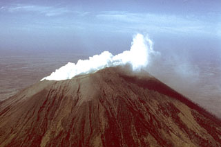 A vigorous white steam plume, seen here from the NW, rises from the summit crater of San Cristóbal volcano in March 1976. Small ash eruptions occurred from San Cristóbal on March 9-10, 1976, dropping ash on the town of Chinandega, 10 km to the SW. Ashfall from another eruption on March 16 was restricted to the summit crater area. Collapse of cones within the summit crater during this eruption created a new 300-m-wide vent.
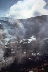 Abundant fumaroles in the summit crater of San Cristóbal volcano emit steam in this November 1973 photo. Trees in the foreground were killed by renewed fumarolic activity that began at San Cristóbal in May 1971 after a quiescence of about three centuries. The billowing cloud in the background is an atmospheric cloud.
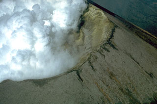 Steam clouds fill much of the crater of San Cristóbal volcano in March 1976. After a quiescence of about five years, small ash eruptions took place at San Cristóbal on March 9-10, 1976, dropping ash on the nearby town of Chinandega. During an eruption on March 16 ash was confined primarily to the summit crater area. The summit crater of San Cristóbal is 500-600 m wide.
 Cerro Negro volcano provides a vantage point for a NW-looking view down the Marrabios Range volcanic chain. The forested slopes in the foreground are part of Rota volcano. The light-colored conical peak in the center is Volcán Santa Clara, part of the Telica volcanic complex, whose principal peak, Telica itself, just pokes its head above the horizon behind and to the right of Santa Clara. The large conical peak on the center horizon is San Cristóbal, the highest peak of the Marrabios Range. The satellitic peak of El Chonco is on the left horizon.
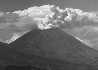 A vigorous steam plume pours from the summit crater of San Cristóbal volcano in December 1971, following an eruption that began on May 3. This mild explosive eruption lasted until early July. The 1971 activity marked the first documented eruptive activity at San Cristóbal since the 17th century. The volcano is seen here from the El Limón gold mine east of the volcano.
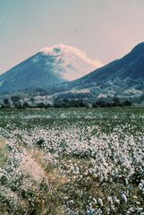 Steam clouds blown to the west by trade winds pour from the summit crater of San Cristóbal in 1977 and blanket the volcano's flanks. The slopes of El Chonco, an eroded stratovolcano at the western end of the San Cristóbal complex, are seen at the right above cotton fields in the foreground. Several lava domes are found near the base of El Chonco, which also produced a 9-km-long lava flow that extends to within 1.5 km of the city of Chinandega, SW of the volcano.
 Boulders litter the foreground in this 1977 view of steaming San Cristóbal (left horizon) and Volcán El Chonco (right horizon). Immediately to the right of El Chonco on its western flank is Loma la Teta, a dacitic lava dome that postdates the collapse. Another small dome, Loma Caparra (barely visible here left of El Chonco and in front of the steaming San Cristóbal volcano in the background) was extruded on the northern flank of El Chonco. The 1105-m-high El Chonco lies at the western end of the San Cristóbal volcanic complex.
 The oldest volcanic center of the San Cristóbal volcanic complex is La Pelona caldera, whose eastern wall forms the forested ridge in the center of the photo. Formation of the caldera was accompanied by the eruption of large amounts of dacitic pumice. Part of the caldera floor is visible at the left, but the western rim and floor has been buried by products of Casita volcano, where this photo was taken. The Marrabios Range volcanoes of Telica, Las Pilas, and conical Momotombo can be seen in the distance.
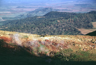 Steam rises from fumaroles in an area of hydrothermally altered ground east of the summit of Casita volcano. The forested slopes in the middle distance to the NE are the flanks of La Pelona caldera, whose floor forms the light-colored area at the right-center. The western part of the caldera was buried by lava flows and pyroclastic material from Casita.
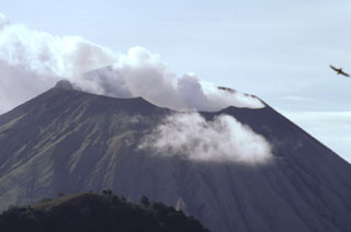 The steaming summit crater of San Cristóbal volcano is viewed here from the top of Casita volcano, whose western crater rim forms the ridge at the lower left. The SW crater rim (upper left) is 140 m above the NE rim, reflecting the influence of trade winds on tephra deposition. The 500 x 600 m wide crater is elongated in an E-W direction, and is several hundred meters deep.
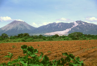 This tranquil scene of steaming San Cristóbal volcano (left) and elongated Casita volcano (right) rising above fields in the León plain is marred by the fresh three-week-old scar of an avalanche and mudflow from Casita. Torrential rainfall accompanying Hurricane Mitch in October 1998 contributed to the collapse near the summit of Casita, which inundated the towns of El Porvenir and Rolando Rodriguez as well as other settlements.
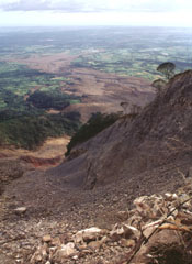 The course of the devastating debris avalanche and mudflow of October 30, 1998, is seen here from the top of the headwall scarp. Collapse of a relatively small area in the foreground (the western collapse scarp is the bare ridge at the right center) near the summit of Casita volcano produced an avalanche that transformed into a devastating mudflow and inundated lowland areas in the distance. The lahar overran two towns, which were located at the area in the sunlight at the upper left. The Pacific Ocean forms the horizon.
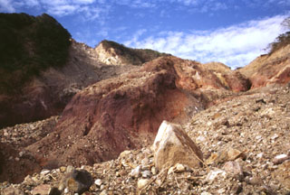 The devastating mudflow of October 30, 1998 originated from a small debris avalanche produced when part of the summit ridge of Casita volcano collapsed during torrential rains accompanying Hurricane Mitch. The source scarp, no more than a few hundred meters in length and a few tens of meters deep, is the light-colored area on the horizon at the upper left. The proximal part of the avalanche, deposits of which are seen in the right foreground, scoured into deeply hydrothermally altered rocks in the middle of the photo.
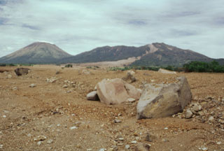 Rapidly moving fine-grained sediment and coarse boulders of a devastating lahar on 30 October 1998 obliterated evidence of the towns of El Porvenir and Rolando Rodriguez, which were located in the foreground area of this photo. The trace of the mudflow forms the light-colored scar extending from its source near the summit of Casita volcano (upper right). The devastating mudflow, which killed about 1600 people, was about 3 m deep at peak flow and 1.5 km wide at the location of the two towns. San Cristóbal volcano is at the upper left.
There are no samples for San Cristóbal in the Smithsonian's NMNH Department of Mineral Sciences Rock and Ore collection.
| Copernicus Browser | The Copernicus Browser replaced the Sentinel Hub Playground browser in 2023, to provide access to Earth observation archives from the Copernicus Data Space Ecosystem, the main distribution platform for data from the EU Copernicus missions. |
| MIROVA | Middle InfraRed Observation of Volcanic Activity (MIROVA) is a near real time volcanic hot-spot detection system based on the analysis of MODIS (Moderate Resolution Imaging Spectroradiometer) data. In particular, MIROVA uses the Middle InfraRed Radiation (MIR), measured over target volcanoes, in order to detect, locate and measure the heat radiation sourced from volcanic activity. |
| MODVOLC Thermal Alerts | Using infrared satellite Moderate Resolution Imaging Spectroradiometer (MODIS) data, scientists at the Hawai'i Institute of Geophysics and Planetology, University of Hawai'i, developed an automated system called MODVOLC to map thermal hot-spots in near real time. For each MODIS image, the algorithm automatically scans each 1 km pixel within it to check for high-temperature hot-spots. When one is found the date, time, location, and intensity are recorded. MODIS looks at every square km of the Earth every 48 hours, once during the day and once during the night, and the presence of two MODIS sensors in space allows at least four hot-spot observations every two days. Each day updated global maps are compiled to display the locations of all hot spots detected in the previous 24 hours. There is a drop-down list with volcano names which allow users to 'zoom-in' and examine the distribution of hot-spots at a variety of spatial scales. |
|
WOVOdat
Single Volcano View Temporal Evolution of Unrest Side by Side Volcanoes |
WOVOdat is a database of volcanic unrest; instrumentally and visually recorded changes in seismicity, ground deformation, gas emission, and other parameters from their normal baselines. It is sponsored by the World Organization of Volcano Observatories (WOVO) and presently hosted at the Earth Observatory of Singapore.
GVMID Data on Volcano Monitoring Infrastructure The Global Volcano Monitoring Infrastructure Database GVMID, is aimed at documenting and improving capabilities of volcano monitoring from the ground and space. GVMID should provide a snapshot and baseline view of the techniques and instrumentation that are in place at various volcanoes, which can be use by volcano observatories as reference to setup new monitoring system or improving networks at a specific volcano. These data will allow identification of what monitoring gaps exist, which can be then targeted by remote sensing infrastructure and future instrument deployments. |
| Volcanic Hazard Maps | The IAVCEI Commission on Volcanic Hazards and Risk has a Volcanic Hazard Maps database designed to serve as a resource for hazard mappers (or other interested parties) to explore how common issues in hazard map development have been addressed at different volcanoes, in different countries, for different hazards, and for different intended audiences. In addition to the comprehensive, searchable Volcanic Hazard Maps Database, this website contains information about diversity of volcanic hazard maps, illustrated using examples from the database. This site is for educational purposes related to volcanic hazard maps. Hazard maps found on this website should not be used for emergency purposes. For the most recent, official hazard map for a particular volcano, please seek out the proper institutional authorities on the matter. |
| IRIS seismic stations/networks | Incorporated Research Institutions for Seismology (IRIS) Data Services map showing the location of seismic stations from all available networks (permanent or temporary) within a radius of 0.18° (about 20 km at mid-latitudes) from the given location of San Cristóbal. Users can customize a variety of filters and options in the left panel. Note that if there are no stations are known the map will default to show the entire world with a "No data matched request" error notice. |
| UNAVCO GPS/GNSS stations | Geodetic Data Services map from UNAVCO showing the location of GPS/GNSS stations from all available networks (permanent or temporary) within a radius of 20 km from the given location of San Cristóbal. Users can customize the data search based on station or network names, location, and time window. Requires Adobe Flash Player. |
| DECADE Data | The DECADE portal, still in the developmental stage, serves as an example of the proposed interoperability between The Smithsonian Institution's Global Volcanism Program, the Mapping Gas Emissions (MaGa) Database, and the EarthChem Geochemical Portal. The Deep Earth Carbon Degassing (DECADE) initiative seeks to use new and established technologies to determine accurate global fluxes of volcanic CO2 to the atmosphere, but installing CO2 monitoring networks on 20 of the world's 150 most actively degassing volcanoes. The group uses related laboratory-based studies (direct gas sampling and analysis, melt inclusions) to provide new data for direct degassing of deep earth carbon to the atmosphere. |
| Large Eruptions of San Cristóbal | Information about large Quaternary eruptions (VEI >= 4) is cataloged in the Large Magnitude Explosive Volcanic Eruptions (LaMEVE) database of the Volcano Global Risk Identification and Analysis Project (VOGRIPA). |
| EarthChem | EarthChem develops and maintains databases, software, and services that support the preservation, discovery, access and analysis of geochemical data, and facilitate their integration with the broad array of other available earth science parameters. EarthChem is operated by a joint team of disciplinary scientists, data scientists, data managers and information technology developers who are part of the NSF-funded data facility Integrated Earth Data Applications (IEDA). IEDA is a collaborative effort of EarthChem and the Marine Geoscience Data System (MGDS). |

