Keyword Collections | Keyword "landslide scarp"
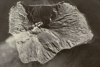 Stromboli is shown in this aerial view with the top of the photo facing NW. It has been continuously active for more than 1,300 years and was constructed in two cycles, the last of which formed the western side of the island. A plume trails to the S from the active vent at the head of the Sciara del Fuoco. The scarp was created by a Pleistocene landslide and channels pyroclastic ejecta and lava flows to the west.
Photo by the Italian Air Force.
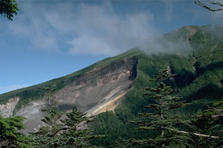 The most prominent feature on the upper SE flank of Ontakesan volcano is the headwall scarp of a volcanic landslide. The landslide occurred on 14 September 1984 with no associated eruptive activity. The resulting debris avalanche traveked 13 km down the Nigori and Otaki river valleys.
Photo by Lee Siebert, 1988 (Smithsonian Institution).
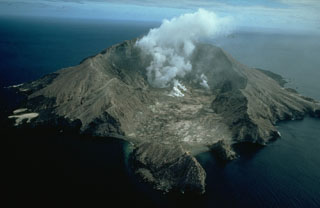 Steam rises from the crater of White Island (also called Whakaari), one of the most active volcanoes of New Zealand. The small, uninhabited 2 x 2.4-km-wide island lies 50 km NE of the North Island. Frequent small-to-moderate explosive eruptions have been recorded since 1826, and Maori legends record earlier eruptions. This view from the SE shows the two overlapping 0.4 x 1.2 km wide craters at the summit of the largely submerged volcano.
Copyrighted photo by Stephen O'Meara.
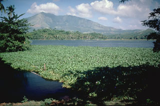 Mount Iriga has a horseshoe-shaped crater opening to the SE that resulted from a large flank collapse during a Holocene eruption. The hummocky terrain in the foreground encloses small ponds on the surface of the debris avalanche deposit.
Photo by Chris Newhall (U.S. Geological Survey).
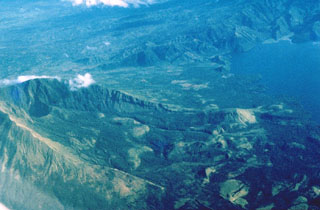 Collapses at the summit or flanks of volcanoes during major volcanic landslides can create large horseshoe-shaped craters that open in the direction of the landslide, like this 2.1 x 3.5 km crater at Iriga in the Philippines. It was produced by a massive landslide during the Holocene. The resulting debris avalanche traveled more than 10 km to the SE and flowed into Lake Buhi at the upper right. This view is from the south, with the summit to the left.
Photo by Chris Newhall (U.S. Geological Survey).
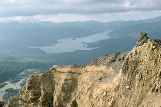 Lake Hibara in the distance was created in 1888 when the partial collapse of Ko-Bandai volcano produced a large debris avalanche that traveled 11 km, nearly to the far end of the lake. The area in front of the lake and the islands in the lake are part of the debris avalanche deposit. The steep wall in the foreground is part of the back headwall of the avalanche scarp.
Photo by Lee Siebert, 1988 (Smithsonian Institution).
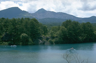 Collapse of the summit of Kobandaisan peak during a phreatic eruption at Bandaisan volcano in 1888 created the 1.5 x 2 km scarp seen here. The lake in the foreground was formed on the irregular surface of a 1.5 km3 debris avalanche deposit. The avalanche buried several villages and blocked river drainages, forming several new lakes. Ashfall from the eruption reached the Pacific coast of Honshu.
Photo by Lee Siebert, 1988 (Smithsonian Institution).
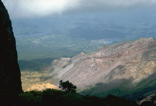 The steep topography at the right is the eastern rim of a scarp created by the 1888 collapse of Koandaisan, one of a group of cones forming Bandaisan. The two lakes in the distance, Onogawa (left) and Akimoto (right), formed after the resulting debris avalanche blocked river drainages. The caldera walls expose stratigraphy of pyroclastic deposits overlain by lava flows.
Photo by Lee Siebert, 1988 (Smithsonian Institution).
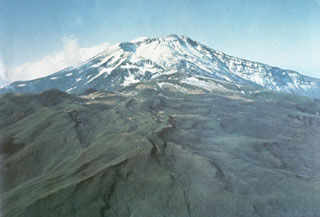 Chokaisan is the largest of the NE Honshu volcanoes, seen here from the NE. The volcano is comprised of two main overlapping edifices, the younger eastern area contains the large collapse scarp that was the source of the Kisakata debris avalanche, seen here opening to the N. Smaller cones later filled much of the area near the rear scarp.
Photo courtesy Ichio Moriya (Kanazawa University).
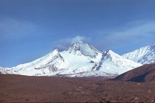 The Novy lava dome formed within the horseshoe-shaped crater that formed by collapse of the summit of Bezymianny in 1956. Intermittent dome growth since 1956 has filled much of the crater. This 11 September 1988 photo from the east shows the lava dome with a broad lava flow (lightly covered by snow) on the NE flank. The flow was produced by slow lava effusion during December 1986 to July 1988. The slopes of Kamen appear to the right.
Photo by Alexander Belousov, 1988 (Institute of Volcanology, Kamchatka, Russia).
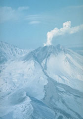 An explosive eruption at Bezymianny that began on 21 October 1993 deposited ash on Bering Island, 515 km to the ESE. Pyroclastic flows from the eruption traveled 14-16 km. Ash plumes rose to 8-15 km on 24 October and additional strong explosions took place on 28 and 29 October. This fall 1993 photo shows the pyroclastic flow and lahar pathways down the eastern flank.
Photo by V.N. Nechaev, 1993 (courtesy of Oleg Volynets, Institute of Volcanology, Petropavlovsk).
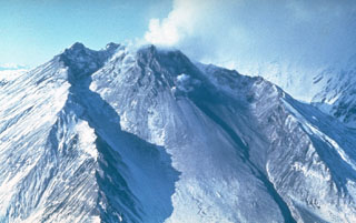 A lava dome fills much of the large horseshoe-shaped crater on the ESE side of Bezymianny in this late-1980s view from the SE. The crater formed during an eruption in 1955-56, which was similar to that of Mount St. Helens in 1980 with flank collapse and lateral blast components. Prior to this eruption Bezymianny had been considered extinct. Subsequent episodic lava dome growth, accompanied by intermittent explosive activity and pyroclastic flows, has largely filled the 1956 crater.
Photo by Yuri Doubik (Institute of Volcanology, Petropavlovsk).
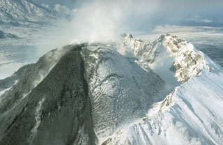 Growth of the Novy lava dome was accompanied by pyroclastic flows through much of 1990. On 10-11 March a short viscous lava flow was extruded, and a 10-km-high ash plume was accompanied by pyroclastic flows that traveled 4-5 km. Lava extrusion, hot avalanches, and occasional pyroclastic flows took place 1-12 April, 11-15 July, 15-20 August, and 26 November-3 December. This photo, taken from the NE on 21 September 1990, shows a dark lava flow descending the eastern flank of the dome.
Photo by Dan Miller, 1990 (U.S. Geological Survey).
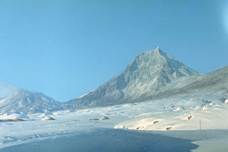 Kamen, seen here from the NE, is a steep-sided stratovolcano of largely Pleistocene age that rises immediately to the north of frequently active Bezymianny volcano (left). The summit of Kamen collapsed about 1,200 years ago, producing a massive debris avalanche to the east, and leaving the steep escarpment that forms the east face of the edifice.
Photo by E.Y. Zhdanova (courtesy of Oleg Volynets, Institute of Volcanology, Petropavlovsk).
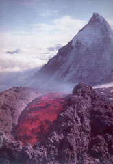 Lava extrudes from a vent on the SE flank of Klyuchevskoy volcano in 1988 with Kamen volcano in the background. Long-term activity at Klyuchevskoy has produced both explosive eruptions and lava effusion, taking place from vents at the summit and on the flanks. The steep eastern flank of Kamen resulted from collapse of the summit about 1,200 years ago, resulting in a massive debris avalanche that traveled approximately 30 km.
Photo courtesy of Anatolii Khrenov, 1988 (Institute of Volcanology, Petropavlovsk).
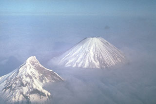 Two of Kamchatka's highest volcanoes rise above the clouds. Their differing morphologies reflect contrasting geologic histories. Construction of extensively eroded Kamen volcano (left) took place during the Pleistocene. It has been relatively inactive since. Its eastern (right) side was removed by a massive landslide about 1,200 years ago, leaving the steep escarpment. Symmetrical Klyuchevskoy, in contrast, is one of Kamchatka's youngest and most active volcanoes.
Photo by Yuri Doubik (Institute of Volcanology, Petropavlovsk).
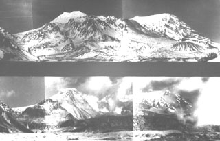 These paired photos show Sheveluch volcano from the south before (top) and after (bottom) a major eruption in 1964. A brief, but powerful eruption on 12 November 1964 resulted in collapse of the south summit of Sheveluch (Crater Top), forming a 1.5 x 3 km open crater seen in the bottom photo. A large debris avalanche swept to the south, after which a Plinian eruption with an ash plume 10-15 km high produced pumice fall and pumiceous pyroclastic flow deposits.
Photo courtesy of Yuri Doubik (Institute of Volcanology, Petropavlovsk).
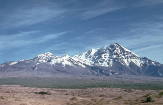 Sheveluch has undergone several large flank collapse events to shape the edifice we see today. The frequent collapses of lava-dome complexes have produced numerous debris avalanches whose deposits cover much of the area south of the volcano. The light-colored hummocky deposits in the foreground were produced during the latest collapse in 1964.
Photo by Kamchatka Volcanic Eruptions Response Team (courtesy of Dan Miller, U.S. Geological Survey).
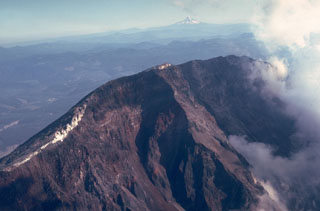 The steep headwall of the scarp created by collapse of St. Helens on 18 May 1980 towers 550 m above the crater floor. The white areas on the crater rim are glaciers that were truncated by the collapse. Steam rises at the right from the new crater in this August 1980 view. Mount Hood is visible in the distance to the south across the Columbia River.
Photo by Lee Siebert, 1980 (Smithsonian Institution).
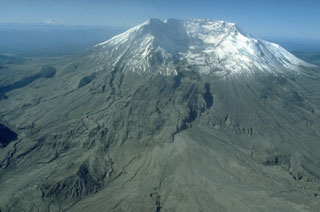 The 2 x 3.5 km horseshoe-shaped crater at Mount St. Helens is typical of scarps formed by massive landslides. On 18 May 1980 the upper 400 m of the summit was removed, leaving the crater open to the N. This event was the world's largest landslide during historical time. The missing portion of the volcano transitioned into the debris avalanche deposits filling the North Fork Toutle River below the volcano.
Photo by Terry Leighley, 1981 (U.S. Geological Survey).
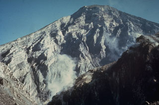 The interior of a stratovolcano is dramatically revealed in a 1-km-wide crater created on the SW flank of Guatemala's Santa María volcano during an eruption in 1902. The 1,200-m-high scarp exposes thin, light-colored lava flows that are interbedded with deposits of fragmented rock produced during growth of the volcano. The 1902 eruption was one of the world's largest during the 20th century.
Photo by Dick Stoiber, 1969 (Dartmouth College).
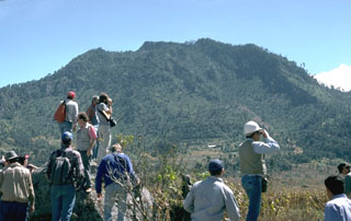 A group of volcanologists are standing on the surface of a debris avalanche deposit produced by collapse of the Cerro Quemado NE flank about 1,150 years ago, with the avalanche scarp in the background to the SW. The scarp, which fills all but the far right-hand slope of this view, is 1 x 1.5 km wide. An associated lateral blast also swept across a 40 km2 area to the NE. The eruption concluded with the emplacement of a small lava dome near the headwall of the scarp.
Photo by Lee Siebert, 1993 (Smithsonian Institution).
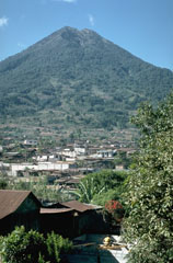 Volcán de Agua towers above the town of Santa María de Jesús on its NE flank. A scarp on the upper north flank extending from the summit crater was the source of a major debris flow in 1541 that destroyed towns on the NW flank. This catastrophe was not accompanied by an eruption.
Photo by Lee Siebert, 1988 (Smithsonian Institution).
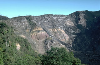 Large-scale collapse of the Pacaya summit sometime between about 1,550 and 600 years ago created a large horseshoe-shaped scarp. Collapse was followed by a large explosive eruption that produced widespread pyroclastic surges. This roughly 150-m-high section of the NW scarp exposes light-colored lava flows overlying pyroclastic deposits of the pre-collapse edifice. Subsequent eruptions have constructed a new cone within the caldera. Lava flows from MacKenney cone (out of view to the right) are slowly filling in the caldera moat.
Photo by Lee Siebert, 1988 (Smithsonian Institution).
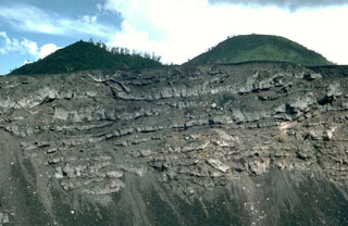 A sequence of thin lava flows forms the upper part of the Pacaya NE crater wall. These basaltic lava flows were erupted during the final stages of an ancestral Pacaya edifice, which collapsed sometime between about 1,550 and 600 years ago to form a large horseshoe-shaped crater. The upper approximately 50 m of the wall is seen in this view with Cerro Grande, an older dome of Pacaya, forming the rounded peak to the right with the Cerro Chiquito cone to the left.
Photo by Lee Siebert, 1988 (Smithsonian Institution).
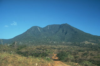 The highest peak of the Orosí volcanic complex is Volcán Cacao, which is seen here from the SW. The summit contains a scarp on the SW as a result of edifice collapse. Orosí is one of a cluster of four eroded and vegetated cones in the Guanacaste Range at the NW corner of Costa Rica.
Photo by Cindy Stine, 1989 (U.S. Geological Survey).
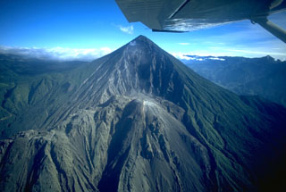 Santa María volcano is seen here in November 1994. The upper SW flank has a 1-km-wide crater formed during a catastrophic eruption in 1902. Two decades later the Santiaguito lava dome began growing at the base of the crater, forming the elongate ridge below the summit and to the left. Since 1922 the Santiaguito dome complex has exhibited frequent explosive activity accompanying episodic periods of dome growth and lava extrusion.
Copyrighted photo by Stephen O'Meara, 1994.
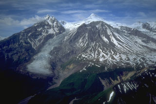 During the late Pleistocene or early Holocene Mount Spurr underwent flank collapse, resulting in the 5-6 km crater that opens to the south shown here in 1993. The collapse produced a debris avalanche that traveled at least 25 km from the summit. The snow-covered peak (center) is a post-collapse lava dome. Crater Peak, in front of it, has been the source of frequent Holocene eruptions.
Photo by Christina Neal, 1993 (U.S. Geological Survey, Alaska Volcano Observatory).
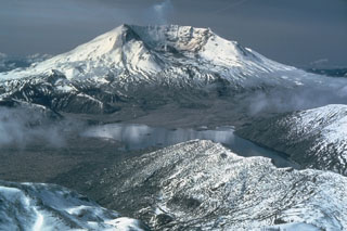 The 1980 eruption of Mount St. Helens dramatically altered the conical profile of the volcano. The eruption left a 2 x 3.5 km wide horseshoe-shaped crater, seen here from the NNE beyond Spirit Lake (center). The landslide of 18 May lowered the summit by 400 m and produced a highly mobile debris avalanche that swept into Spirit Lake and traveled down the North Fork Toutle River. The associated northward-directed lateral blast devastated about 600 km2.
Photo by Lyn Topinka, 1981 (Cascades Volcano Observatory, U.S. Geological Survey).
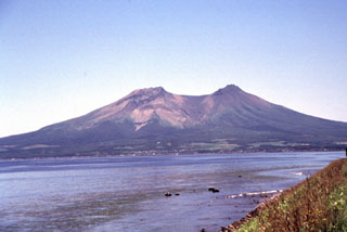 The two summit peaks of Komagatake, seen here from the NW, are remnants of a scarp formed by prehistoric flank collapse towards the NW. Several episodes of growth and collapse have occurred, with the most recent in 1640 when the flank collapsed towards the E.
Photo by Mitsuhiro Yoshimoto, 1995 (Hokkaido University).
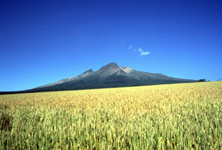 From the WSW the highest visible point of Komagatake is the rim of a scarp that opens to the east (right). The sharp peak to the left is Kengamine, the summit and part of the rear rim of the scarp.
Photo by Mitsuhiro Yoshimoto, 1995 (Hokkaido University).
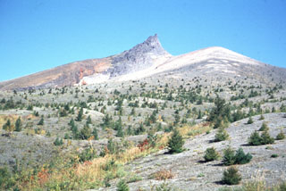 The dune-like surface in the foreground consists of pyroclastic surge deposits from the 1929 eruption of Komagatake. This 1991 S-flank view shows Kengamine (center), the summit of Komagatake, which is the rim of a large scarp that formed when the summit collapsed to the east (right).
Photo by Shinji Takarada, 1991 (Geological Survey of Japan).
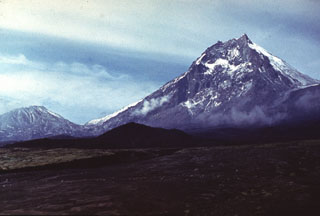 Kamen lies at the center of a N-S-trending chain of volcanoes, flanked by Bezymianny (left) and Klyuchevskoy. Kamen formed during the late Pleistocene and activity continued into the Holocene. A major flank collapse about 1,200-1,300 years ago removed much of the eastern side of the volcano, leaving the steep escarpment seen in this view.
Photo by Vera Ponomareva, 1975 (Institute of Volcanic Geology and Geochemistry, Petropavlovsk).
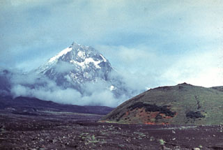 Kamen towers above the Karpinski scoria cone (left) on the ESE flank of Klyuchevskoy volcano with lahar deposits from Klyuchevskoy in the foreground. The eastern side of Kamen was removed by a massive volcanic landslide about 1,200 years ago.
Photo by Vera Ponomareva, 1975 (Institute of Volcanic Geology and Geochemistry, Petropavlovsk).
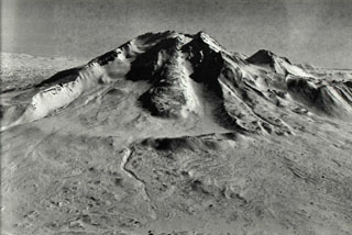 The western side of Taunshits contains a large horseshoe-shaped crater that formed about 8,000 years ago during an eruption that produced a debris avalanche and directed blast similar to that at Mount St. Helens in 1980. A viscous lava flow (center) erupted after the collapse from a vent at the top of the collapse scarp.
Photo by Nikolai Smelov, 1998 (courtesy of Vera Ponomareva, Institute of Volcanic Geology and Geochemistry, Petropavlovsk).
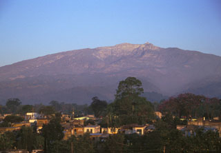 Large compound horseshoe-shaped scarps, formed in part by edifice collapse, are visible near the summit of the eastern side of Cofre de Perote volcano. The massive size of the edifice can be appreciated in this photo taken from the city of Coatepec, which lies 21 km ESE and 3,000 m below the summit.
Photo by Lee Siebert, 1999 (Smithsonian Institution).
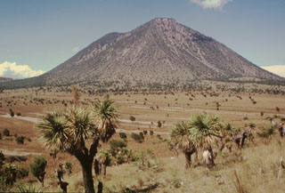 The SE-most of the two Las Derrumbadas lava domes is seen here from the SE. The extensively altered dome is surrounded by debris avalanche deposits. The more recent avalanche deposits consist almost entirely of microcrystalline rhyolite from the core of the dome. They left horseshoe-shaped collapse scarps such as the one visible to the upper right. These scarps reveal areas of intense alteration to kaolinite produced by prolonged fumarolic activity.
Photo by Hugo Delgado-Granados, 1995 (Universidad Nacional Autónoma de México).
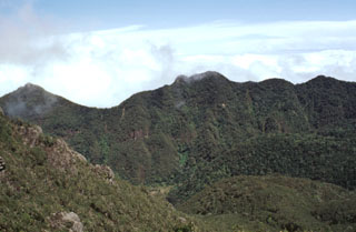 The northern area of the Volcán Barú collapse scarp is seen here from near the summit. The scarp at this point is about 300 m high, much of which has been filled in by a lava dome complex. The massive horseshoe-shaped collapse scar formed as a result of edifice collapse and is about 10 km long and 6 km wide.
Photo by Lee Siebert, 1998 (Smithsonian Institution).
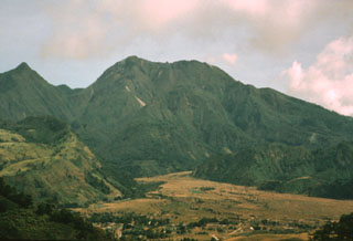 The 10-km-long northern wall of Volcán Barú's horseshoe-shaped collapse scarp extends from the grassy ridge at the lower left to the peak to the upper left. In the center is the large lava dome complex that has filled much of the scar. The light-colored valley floor of Río Macho de Monte in the foreground is composed of pyroclastic flow deposits related to growth and collapse of the summit lava domes. The town of Nuevo Bambito is visible at the bottom of the photo.
Photo by Kathleen Johnson, 1995 (University of New Orleans).
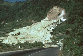 The 80-m-high headwall scarp of the 5 January 1991 landslide at the Almolonga volcano Zunil geothermal field exposes the regional Zunil fault zone. The avalanche deposit extends about 800 m from the source and damaged the highway between Quetzaltenango and the town of Retalhuleu on the Pacific coastal plain. The avalanche destroyed a church and more than a half-dozen houses, killing 23 people. The elevation difference from the head of the scarp to the distal end of the deposit was 250 m.
Photo by Lee Siebert, 1993 (Smithsonian Institution).
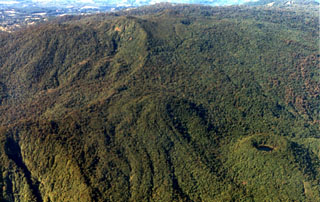 The summit area of Volcán Barva is composed of a series of overlapping cones with about a dozen vents. At the lower right is Danta cone with a small crater lake. Forest-covered lava flows can be seen to its left. Barva is the topographic high point of Braulio Carillo National Park.
Photo by Federico Chavarria Kopper, 1999 (courtesy of Eduardo Malavassi, OVSICORI-UNA).
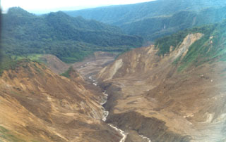 An avalanche produced during an 8 December 1994 phreatic explosion at Irazú traveled down the Río Sucio to the north, destroying trees high up the banks of the river. Associated lahars swept many kilometers farther down the river, which flows through the Cordillera Volcánica Central Forest Reserve. The explosion formed a new crater in a geothermal area north of the main crater.
Photo by Jorge Barquero, 1998 (OVSICORI-UNA).
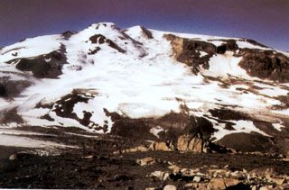 Snowy Mountain volcano lies 15 km NE of Mount Katmai. An ice-topped Holocene lava dome on the central skyline partly fills an ice-mantled scar that formed as a result of edifice collapse of the NE flank. The summit (Peak 7090) lies just behind the dome to its right. The Serpent Tongue glacier flows from the amphitheater.
Photo courtesy of U.S. Geological Survey, 1999 (published in Hildreth et al., 2001).
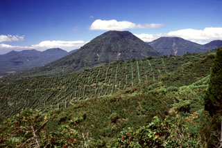 The escarpment across the middle of the photo with vertical rows of coffee plantation trees across the scarp in is the NW wall of a large caldera formed by edifice collapse of Santa Ana volcano during the late Pleistocene. About 5 km of the scarp is exposed; the remainder is buried beneath ejecta and lava flows from modern Santa Ana volcano. Cerro los Naranjos volcano rises beyond the scarp, and other peaks of the Apaneca range form the horizon on either side.
Photo by Lee Siebert, 2002 (Smithsonian Institution).
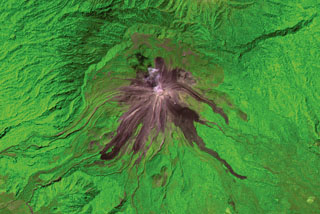 Recent lava flows from Volcán de Colima radiate from the summit in this 2001 ASTER satellite image (N is at the top; this image is approximately 13 km wide). The flows on the E and SE flanks were produced in 1975-76 and reached up to 3.5 km from the summit. The longest flows down the SW flank formed in 1998-99; the three major lobes seen here covered a SW-flank flow from 1991. The headwall of the horseshoe-shaped scarp to the N was produced by collapse of an older edifice.
ASTER satellite image, 2001 (National Aeronautical and Space Administration, processed by Doug Edmonds).
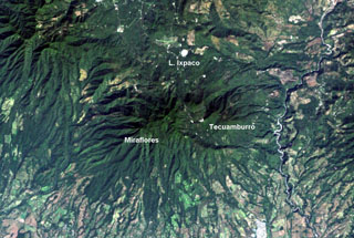 The Tecuamburro volcanic complex has a diverse history. Collapse of the ancestral Pleistocene Miraflores edifice underwent collapse, producing an avalanche deposit that traveled across the Río los Esclavos (right) and forming a large horseshoe-shaped crater open to the east. The modern Tecuamburro complex, consisting of four lava domes, was constructed within this scarp. The Laguna Ixpaco crater was created about 2,900 years ago within the much larger Pleistocene Chupadero crater.
NASA Landsat image, 2000 (courtesy of Loren Siebert, University of Akron).
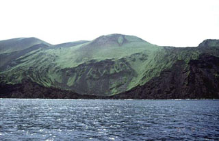 Oshima-Oshima volcano is seen here from the N with the Kanpodake cone (back-center) that formed during the 1741 eruption. Major edifice collapse that year produced a large scarp open to the north, with the walls visible at the sides of the image. The 4-km-wide island is 55 km W of the SW tip of Hokkaido, and is the emergent summit of two coalescing volcanoes: Higashiyama at the eastern end of the island, and Nishiyama at the western end.
Copyrighted photo by Tomoyo Hayakawa (Japanese Quaternary Volcanoes database, RIODB, http://riodb02.ibase.aist.go.jp/strata/VOL_JP/EN/index.htm and Geol Surv Japan, AIST, http://www.gsj.jp/).
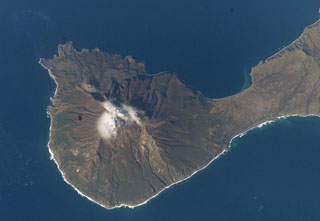 Goriaschaia Sopka dome and the Milne cone are shown here on the SW end of Simushir Island. Milne is the larger snow-capped peak and Goriaschaia Sopka is on the NW flank within a large open crater. The dome has produced lava flows that form the irregular shoreline to the N, some of which are visible in this NASA Space Shuttle image.
NASA Space Shuttle image STS112-E-5671, 2002 (http://eol.jsc.nasa.gov/).
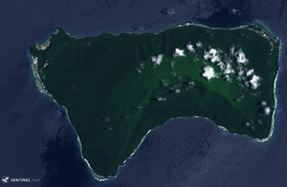 Ta’u Island in eastern American Samoa is the exposed portion of the Lata shield volcano, seen in this 29 October 2019 Sentinel-2 satellite image (N is at the top; this image is approximately 13 km across). Smaller cones and craters have formed across the flanks, and a major flank collapse event around 22 ka resulted in the steep scarps on the southern side of the island.
Satellite image courtesy of Copernicus Sentinel Data, 2018.
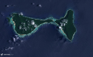 Ofu (left) and Olosega (right) in eastern Samoa are parts of the same volcano separated by the Asaga Strait, with the island group reaching nearly 9 km across (including the smaller island to the west), shown in this 29 October 2018 Sentinel-2 satellite image (N is at the top). The islands have likely been shaped by flank failures with resulting debris avalanches below sea level.
Satellite image courtesy of Copernicus Sentinel Data, 2018.
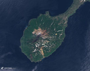 Kuntomintar comprises the southern part of Shiashkotan Island, shown in this June 2020 Planet Labs satellite image monthly mosaic (N is at the top; this image is approximately 8.5 km across). Several Holocene craters are preserved along the summit and geothermal activity occurs within the active crater inside the large scarp that opens to the NW.
Satellite image courtesy of Planet Labs Inc., 2019 (https://www.planet.com/).
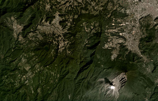 The large scarp of Siete Orejas is down the center of this November 2020 Planet Labs satellite image monthly mosaic (N is at the top; this image is approximately 21 km across). Seven peaks surround the scarp, which likely formed during flank collapse towards the south. The city of Quetzaltenango is NE and Santa María volcano is SE, with a gas plume rising from the Caliente Dome. The Volcan Chicabal is on the SW flank, containing Chicabal Lake.
Satellite image courtesy of Planet Labs Inc., 2020 (https://www.planet.com/).
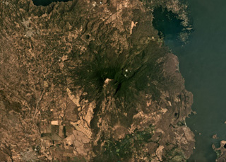 Two major flank-collapse scarps on the NE and SW sides of Mombacho are visible in this March 2019 Planet Labs satellite image monthly mosaic (N is at the top; this image is approximately 25 km across). The islands to the NE are part of the 56.8 km2 Las Isletas debris avalanche deposit; the 49.5 km2 El Crater debris avalanche deposit is to the S. The La Danta debris avalanche deposit is between the two on the SE flank and surrounding area.
Satellite image courtesy of Planet Labs Inc., 2019 (https://www.planet.com/).
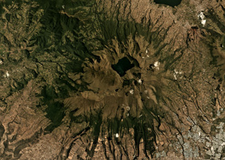 Mojanda volcano has a 3-km-wide caldera that contains the Laguna Grande de Mojanda, shown in this August 2019 Planet Labs satellite image monthly mosaic (N is at the top; this image is approximately 24 km across). The complex contains the older Fuya Fuya to the W, and Mojanda to the E. Fuya Fuya underwent a large flank collapse that produced the horseshoe-shaped scarp on the SW side, opening towards the W. The Cerro el Panecillo dome is on the NW flank.
Satellite image courtesy of Planet Labs Inc., 2019 (https://www.planet.com/).
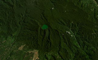 Malintang volcano in Indonesia is shown in this August 2020 Planet Labs satellite image monthly mosaic (N is at the top; this image is approximately 25 km across). A crater lake is present at the summit. A large horseshoe-shaped scarp is visible down the southern flank, likely formed through flank collapse.
Satellite image courtesy of Planet Labs Inc., 2020 (https://www.planet.com/).
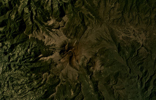 Sotará in Colombia is shown in the center of this February 2020 Planet Labs satellite image monthly mosaic (N is at the top; this image is approximately 19 km across). The edifice formed within a 4.5-km-diameter caldera and has a collapse scarp open towards the SW, as well as several lava domes in the summit area. Thick lava flows and domes have been emplaced within the scarp.
Satellite image courtesy of Planet Labs Inc., 2020 (https://www.planet.com/).
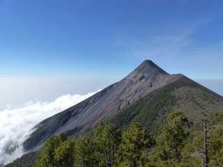 Fuego is seen here from Volcán Acatenango in February 2017. The ridge to the right of Fuego’s summit is a remnant of the older La Meseta edifice that underwent collapse approximately 9,000 years ago. The Barrancas Hondas and Las Lajas ravines that channel pyroclastic flows and lahars are visible on Fuego’s eastern flanks (left side); Honda is closer and deeper, with areas of red oxidation.
Photo by Ailsa Naismith, 2017.
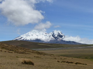 Volcán Antisana is seen here looking NE from highway E20 in December 2015. Northeast Peak is to the right and the East Ridge is to the left, with a collapse scarp between them.
Photo by Ailsa Naismith, 2015.
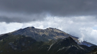 This October 2015 view is from the summit of Rucu Pichincha (“Old Man Pichincha” in the indigenous Quechua language) facing west towards the Guagua Pichincha (“Baby Pichincha”) vent. Eruptions have produced ashfall that has impacted Quito, 14 km W. The recently active vent is situated within a landslide scarp that opens towards the SW, and an older landslide scarp is on the western flank.
Photo by Ailsa Naismith, 2015.


