Theme Collections | Paul Kimberly Photos
Theme collections are galleries not specifically related to volcanic hazards, processes, research, types, or features. This includes subjects such as different satellite platforms, astronaut photos from the Space Shuttle, specific photographers, or other special collections.
Image Gallery for Paul Kimberly Photos
Photos by Paul Kimberly (Smithsonian Institution). There are 80 images available.
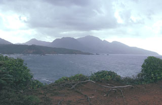
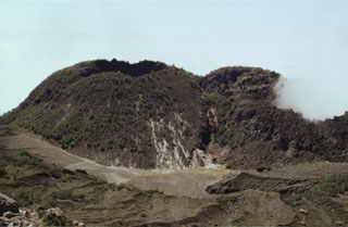
 The 1902 lava dome fills much of the l'Etang Sec summit crater, as seen here from Morne Macouba, north of the summit. Following the catastrophic eruption on May 8, 1902, rapid growth of a summit lava dome began; it reached 350 m height by July 6. Intermittent explosive activity continued until October 31, 1903 and lava dome growth continued on a diminishing scale until October 5, 1905. The famous spine at one point rose to 1617 m, 220 m above the current summit (the 1929 lava dome), before it crumbled away.
Photo by Paul Kimberly, 2002 (Smithsonian Institution).
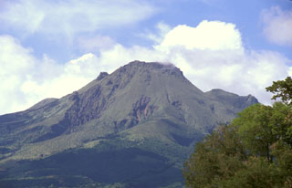 The 1929 lava dome forms the summit of Mount Pelée in this telephoto view from St. Pierre. The modern volcano was constructed within a scarp produced by collapse of the volcano about 9000 years ago. The irregularity on the right-hand flank is part of the eastern summit crater rim and the Aileron lava dome, which erupted about 9700 years ago.
 Photo by Paul Kimberly, 2002 (Smithsonian Institution).
 This view from the summit of Mount Pelée shows the eastern rim of l'Etang Sec, the current summit crater of Mount Pelée. The 1902 and 1920 lava domes fill much of this crater. The town with reddish roofs at the far right is Morne Rouge, affected by pyroclastic flows from the 1902 eruption.
Photo by Paul Kimberly, 2002 (Smithsonian Institution).
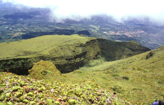
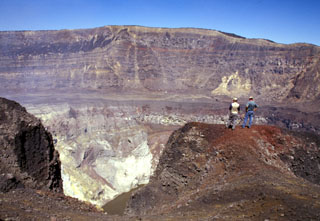
 This view looks west from the 1902 lava dome within the summit crater of Mount Pelée. The area beyond the grassy knoll was part of the first portion of the ancestral volcano that underwent massive edifice collapse more than 100,000 years ago. This massive collapse produced a 25 cu km debris avalanche that swept into the Caribbean Sea up to 70 km from the coastline. Mount Pelée was subject to three major episodes of edifice collapse--the second took place about 25,000 years and the third about 9000 years ago.
 Photo by Paul Kimberly, 2002 (Smithsonian Institution).
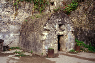 This prison cell in the city of St. Pierre housed one of the only two survivors of the 8 May 1902, eruption of Mount Pelée. Devastating pyroclastic flows and surges swept down the SW flank of the volcano early in the morning and destroyed the city, killing 28,000 people in the world's deadliest eruption of the 20th century.
 Photo by Paul Kimberly, 2002 (Smithsonian Institution).
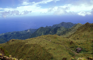
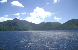
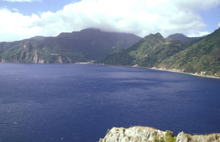 The promontory at Scotts Head provides a vantage point overlooking the partially submerged Plat Pays caldera, widely breached to the west at Soufrière Bay. The caldera, which partially truncated Morne Plat Pays stratovolcano (in the clouds on the center horizon) formed about 39,000 years ago. Its margins extend from north of Sorcière lava dome (far left) to near Scotts Head. Morne Patates, the dome along the coast at the right-center, is the youngest post-caldera lava dome and was active until at least about 700 years ago.
Photo by Paul Kimberly, 2002 (Smithsonian Institution).
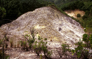 The Sulfur Springs thermal area was the site of combustion and melting of sulfur deposits in 1994 that produced a sulfur flow over an area of about 1 km2, prompting reports of a volcanic eruption. Measured fumarole temperatures at Sulfur Springs have ranged between about 90 and 100 degrees Centigrade over the past century.
Photo by Paul Kimberly, 2002 (Smithsonian Institution).
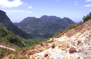 The youngest cluster of lava domes of the Morne Plat Pays volcanic complex, Morne Rouge, Crabier, and Morne Patates (left to right) is seen here from the north at the upper Sulfur Springs thermal area. The cliff in the shadow at the left is the west-facing wall of the arcuate Morne Plat Pays caldera, which formed about 39,000 years ago in association with the eruption of the Grand Bay Ignimbrite and a lateral flank collapse to the west.
Photo by Paul Kimberly, 2002 (Smithsonian Institution).
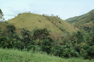
 Morne Plat Pays (left), Morne Patates (right-center) and Crabier (right) at the SW tip of Dominica are seen from the SW. The Morne Plat Pays volcanic complex contains the Morne Plat Pays stratovolcano and a complex of central lava domes. The complex is cut by a large depression, partly filled by the lava domes, that was formed by collapse of the volcano during the late Pleistocene. The collapse scarp is 400-900 m high, and submarine debris-avalanche blocks from the collapse are visible in bathymetry.
Photo by Paul Kimberly, 2002 (Smithsonian Institution).
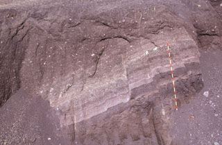
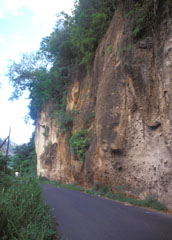 A roadcut in the Roseau River valley on the outskirts of the capital city reveals deposits of the Roseau Tuff. This thick sequence of pyroclastic flows (sometimes welded), pyroclastic surges, and pumice-lapilli airfall deposits was erupted between about 40,000 and 25,000 years ago.
 Photo by Paul Kimberly, 2002 (Smithsonian Institution).
 Morne aux Diables volcano rises above the Atlantic coast of NW Dominica. The summit of the volcano is formed by a complex of lava domes, and flank domes, which extend in a roughly E-W chain across the southern flank of the volcano, are visible on the left horizon.
 Photo by Paul Kimberly, 2002 (Smithsonian Institution).
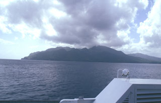 The NW side of Morne aux Diables volcano at the northern tip of Dominica is seen from the hydrofoil ferry between Guadeloupe and Dominica. Lava domes are prominent on the 681-m-high volcano, both at the summit and its flanks. Bathymetry reveals evidence for a twin-peaked lava dome about 5 km off the NW coast that reaches to within 153 m of the sea surface. Both domes, known informally as Twin Peaks, rise more than 1000 m above the sea floor.
Photo by Paul Kimberly, 2002 (Smithsonian Institution).
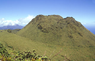
 La Soufrière lava dome, forming the summit of Soufrière Guadeloupe volcano, was emplaced at the end of a major eruption that took place around the mid-15th century. The eruption began with collapse of part of a previous lava dome forming a debris avalanche, followed by a major explosive eruption in which dacitic pumice and andesitic banded scoria were sequentially ejected. The eruption concluded with growth of La Soufrière summit lava dome, which is seen here from the north.
Photo by Paul Kimberly, 2002 (Smithsonian Institution).
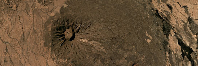
 The escarpment cutting diagonally downward across the middle of the photo in front of conical Cerro los Naranjos volcano is the NW wall of a large late-Pleistocene caldera formed by edifice collapse of Santa Ana volcano. The exposed portion of the collapse scarp is up to about 200 m high along a roughly 5 km segment of the arcuate avalanche caldera. Pyroclastic ejecta and lava flows from modern Santa Ana volcano have filled in much of the scarp in the foreground and have buried it completely on the northern and eastern sides.
 Photo by Paul Kimberly, 2002 (Smithsonian Institution).
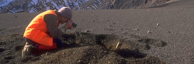
 Geologists on the southern rim of Santa Ana's summit crater stand above the hydrothermally altered walls of the more than 100-m-deep inner crater. A near-vertical fault is visible in the far northern wall of the larger crater beyond the crater floor in the center of the photo, above the inner crater. Lava flows exposed in the crater wall are overlain by a roughly 10-m-thick light-brown sequence of phreatomagmatic tephra layers.
Photo by Paul Kimberly, 2002 (Smithsonian Institution).
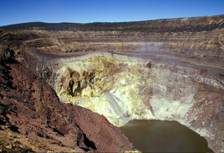 Gases rise from the hydrothermally altered western wall of Santa Ana's inner summit crater above the acidic lake. A steep path down the NE crater wall (far right) provides access to the lake for geochemical sampling. Sequences of phreatomagmatic tephra units more than 100 m thick are exposed in the walls of the outer summit craters.
Photo by Paul Kimberly, 2002 (Smithsonian Institution).
 San Vicente is seen here in 2002 with landslide scarps that were produced during the January 2001 earthquake. The San Vicente area and towns at the base of the volcano were particularly affected by the tectonic earthquake and suffered extensive damage. The Tecapa volcanic complex and conical San Miguel volcano are in the distance.
Photo by Paul Kimberly, 2002 (Smithsonian Institution).
 Flights from the international airport at San Salvador often pass close to San Vicente volcano, seen here from the south. The edifice is within the La Carbonera caldera, which formed during a major Plinian explosive eruption during the Pleistocene.
Photo by Paul Kimberly, 2002 (Smithsonian Institution).
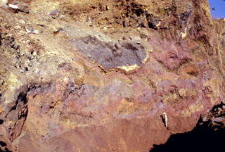 Multi-colored remnants of Santa Ana volcano are exposed in a quarry wall in a hummock of the Acajutla debris avalanche deposit with a geologist to the lower right for scale. This quarry in Cerro el Jicaro, 6 km SE of the city of Sonsonate, displays characteristic textures of debris avalanche deposits. Individual segments are faulted and slightly deformed, but retain their integrity despite being transported about 18 km from the volcano.
 Photo by Paul Kimberly, 1999 (Smithsonian Institution).
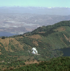 A steam plume rising from a geothermal site in Amatitlán caldera is seen here from the caldera rim of Pacaya, with Guatemala City in the background. Laguna Calderas contains the lake to the right and beyond the ridge to the left is part of Lake Amatitlán. The 14 x 16 km Amatitlán caldera produced a large number of major explosive eruptions that covered the current site of Guatemala City with pyroclastic flows during the late Pleistocene. The caldera retains a high heat flow that is being exploited for geothermal energy.
Photo by Paul Kimberly, 1999 (Smithsonian Institution).
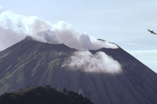
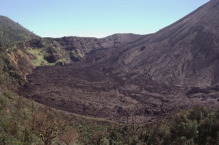 Lava flows erupted in September 1998 cover the floor of the caldera moat of Pacaya. The caldera wall here is about 100 m high. Frequent lava flows from MacKenney cone, whose flank is to the right, have been gradually forming deposits to tens of meters higher than it was a decade ago. Eruptions at MacKenney cone have been frequent since its initial eruption in 1965. The ridge in the foreground is the crater rim of Cerro Chino.
Photo by Paul Kimberly, 1999 (Smithsonian Institution).
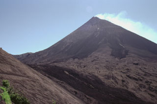 The degassing MacKenney cone at Pacaya is seen here from the NW below Cerro Chino scoria cone, whose ash-covered flank appears to the left. Darker lava flows that were erupted in 1998 descend from the summit and down the moat to the left. This flow and the two dark lobes above were erupted during the 18-19 September 1998 eruption. Lighter tephra deposits between the flows cover previous lava flows.
Photo by Paul Kimberly, 1999 (Smithsonian Institution).
 Rapidly moving fine-grained sediment and coarse boulders of a devastating lahar on 30 October 1998 obliterated evidence of the towns of El Porvenir and Rolando Rodriguez, which were located in the foreground area of this photo. The trace of the mudflow forms the light-colored scar extending from its source near the summit of Casita volcano (upper right). The devastating mudflow, which killed about 1600 people, was about 3 m deep at peak flow and 1.5 km wide at the location of the two towns. San Cristóbal volcano is at the upper left.
Photo by Paul Kimberly, 1998 (Smithsonian Institution).
 The steaming summit crater of San Cristóbal volcano is viewed here from the top of Casita volcano, whose western crater rim forms the ridge at the lower left. The SW crater rim (upper left) is 140 m above the NE rim, reflecting the influence of trade winds on tephra deposition. The 500 x 600 m wide crater is elongated in an E-W direction, and is several hundred meters deep.
Photo by Paul Kimberly, 1998 (Smithsonian Institution).
 Telica volcano is seen here in a telephoto view looking down the Marrabios Range from near the summit of Casita volcano. A thin steam plume rises from a fumarole in the summit crater. Behind Telica on the left horizon is Las Pilas volcano, and the conical peak at the extreme right is Cerro Asososca, at the south end of the Las Pilas complex.
Photo by Paul Kimberly, 1998 (Smithsonian Institution).
 The Aguas Zarcas group of nine basaltic scoria cones is located on the northern flank of the Platanar-Porvenir complex. These cones lie 10-17 km behind the volcanic front of Costa Rica.
 Photo by Paul Kimberly, 1998 (Smithsonian Institution).
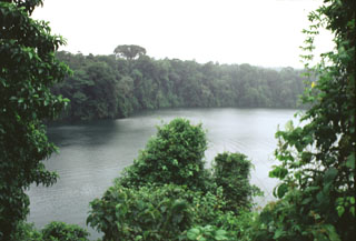 The Laguna Río Cuarto maar is at the northern end of a chain of vents extending to about 18 km from Poás volcano. The 600 x 750 m wide maar has a maximum depth of 66 m and the crater walls rise 4-20 m above the lake surface. The maar erupted through lahar and alluvial deposits on the coastal plain at an elevation of about 400 m above sea level.
Photo by Paul Kimberly, 1998 (Smithsonian Institution).
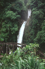 Radial drainages draped with lush vegetation descend the flanks of Poás volcano. These waterfalls on the Río La Paz lie on the eastern flank of Poás along the road between the central valley and the Atlantic coastal plain. NE-flank drainages empty into the Río Sarapiquí and then the Río San Juan en route to the Carribean Sea. Poás is the centerpiece of a national park that preserves highland forests and abundant wildlife.
 Photo by Paul Kimberly, 1998 (Smithsonian Institution).
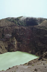 The two main summit craters of Irazú are seen here from the west in 1998. A lake fills the bottom of the main crater (Cráter Principal), with the older Diego de la Haya crater at the top of the photo.
 Photo by Paul Kimberly, 1998 (Smithsonian Institution).
 The blocky lava flow in the foreground was erupted in 1772 from a vent on the northern side of Old Masaya cone (extreme left). The dark flow at the upper right spilling over the rim of Nindirí crater was erupted in 1670 and traveled down the northern flank of the cone.
Photo by Paul Kimberly, 1998 (Smithsonian Institution).
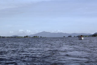 A small boat plies the waters of Ensenada de Aseses, with Zapatera Island forming the horizon to the SE. In the middle distance are the small island hummocks of Las Isletas, formed by a debris avalanche from Mombacho volcano, out of view to the right. The conical peak on the distant left horizon is Concepción volcano; the low, rounded peak to its left is Cerro las Banderas, a pyroclastic cone on the NE tip of Zapatera Island.
Photo by Paul Kimberly, 1998 (Smithsonian Institution).
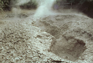 Emissions rise from mud pools at the Aguas Termales thermal area, one of several at the lower southern flank of the Rincón de la Vieja massif in the national park of the same name.
Photo by Paul Kimberly, 1998 (Smithsonian Institution).
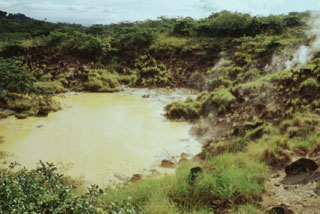 Gas emissions rise from vents in the Aguas Termales thermal area on the southern flank of Rincón de la Vieja volcano. A popular trail in Rincón de la Vieja National Park goes around the mud pools and fumaroles of the geothermal area.
Photo by Paul Kimberly, 1988 (Smithsonian Institution).
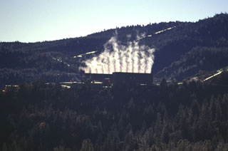
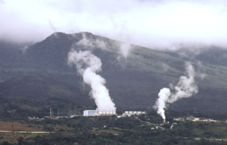 Steam plumes rise from power plants of the Miravalles geothermal project in 1998, which began production in 1994.
Photo by Paul Kimberly, 1998 (Smithsonian Institution).
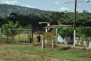 The San Jacinto-Tizate geothermal prospect at the eastern end of the Telica volcanic complex has undergone intermittent exploration by a Nicaraguan-Russian consortium. During the 1993-1995 period, seven exploration-production wells were drilled in the San Jacinto-Tizate geothermal area. The wells had total depths between 724 and 2235 m and encountered temperatures from 264 to 289 degrees Centigrade. Subsequent development by Polaris Geothermal resulted in inauguration of the first 10 MW production well in June 2005.
Photo by Paul Kimberly, 1998 (Smithsonian Institution).
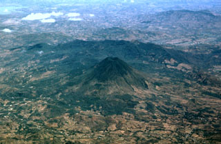
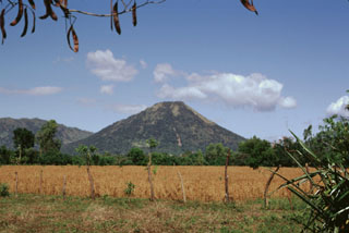 Conical Santa Clara volcano lies at the SE end of the Telica volcanic complex. The 834-m-high stratovolcano, seen here from the south, has a small summit crater about 150 m in diameter. Santa Clara was considered to have been active during the 16th century, and early explorers reported the volcano to be smoking, but no specifically dated eruptions have been recorded.
Photo by Paul Kimberly, 1998 (Smithsonian Institution).
 The buildings seen in the center of the photo along the shore of Lake Managua are part of the Patricio Arguello Ryan geothermal plant on the lower southern flank of Momotombo volcano. At one point the power plant produced 25% of electrical power generation for the country. In the distance on the left horizon is Cerro Montoso, a peak on the rim of Monte Galán caldera.
Photo by Paul Kimberly, 1998 (Smithsonian Institution).
 The N-S-trending Nejapa-Miraflores alignment of cones cuts across the western outskirts of the city of Managua and extends across a bay of Lake Managua onto the Chiltepe Peninsula. Cerro San Carlos (center) lies along the southern side of the bay, while the conical peak of Volcán Chiltepe is visible at the upper left on the eastern tip of the Chiltepe Peninsula.
Photo by Paul Kimberly, 1998 (Smithsonian Institution).
 The Media Luna scoria cone at the NW side of La Yeguada volcanic complex is one of its youngest features. A lava flow that erupted from the western flank reached about 3 km to the west. A radiocarbon date of 360 ± 90 years before present (BP) was obtained from lake sediment formed when the lava flow blocked a local drainage.
 Photo by Paul Kimberly, 1998 (Smithsonian Institution).
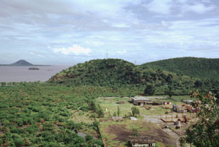
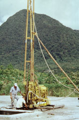 This drill rig on the floor of El Valle de Antón caldera is part of a major geothermal exploration program at El Valle volcano. In the background to the north is Cerro Gaital, the highest of three post-caldera lava domes along the northern caldera rim.
 Photo by Paul Kimberly, 1998 (Smithsonian Institution).
 The post-caldera Cerro Pajita, Cerro Gaital, and Cerro Caracoral lava domes (seen left to right from La India Dormida on the western caldera rim) formed along an E-W trend about 900,000 years ago. The easternmost dome is Cerro Caracoral. Gabbro xenoliths are common in the central dome, Cerro Gaital. The Río Mar pyroclastic flows were produced about 40,000-50,000 years ago from a vent on the caldera floor between the Gaital and Pajita domes.
Photo by Paul Kimberly, 1998 (Smithsonian Institution).
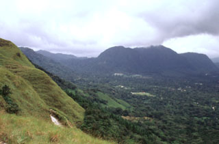
 The town of El Valle occupies the El Valle de Antón caldera floor. This view looks across the 6-km-wide caldera from La India Dormida on the western rim. A lake once covered the caldera floor, contributing to large phreatoplinian eruptions during the late Pleistocene. At the far-left is Cerro Caracoral, the easternmost of three lava domes along the northern caldera margin. More recent Plinian eruptions originated from the Mata Ahogado crater, east of the caldera rim.
Photo by Paul Kimberly, 1998 (Smithsonian Institution).
 Some of the youngest lava domes of Volcán Barú are SW of the summit dome and rise about 80 m high. The summit of the SE-most dome (left) has a roughly 200-m-wide crater.
Photo by Paul Kimberly, 1998 (Smithsonian Institution).
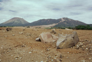
 Las Lagunas, a group of small ponds west of Volcán Barú, formed between hummocks of a massive debris avalanche deposit that resulted from flank collapse. Las Lagunas is 5 km WSW of the town of Hato del Volcán and 19 km from the headwall of the collapse scarp where it originated.
Photo by Paul Kimberly, 1998 (Smithsonian Institution).
 Near the center of this photo is Cerro Corero de la Charca, a lava dome that formed at the northern end of a fault-bounded horst about 220,000 years ago within a small crater within El Castillo dome (right). Recent activity at El Castillo occurred on its northern flanks at the intersection of major faults trending NNW, NW, and ENE.
Photo by Paul Kimberly, 1998 (Smithsonian Institution).
 Cerro Corero de la Charca rising above the western shore of Laguna La Yeguada is the youngest silicic feature of La Yeguada complex (also known as Chitra-Calobre). The compound 1229-m-high rhyodacitic lava dome was erupted about 220,000 years ago within a 1.5-km-wide caldera and produced pyroclastic-flow deposits that extend to the SE. This eruption occurred at the northern end of the El Castillo horst and marked its latest activity.
Photo by Paul Kimberly, 1998 (Smithsonian Institution).
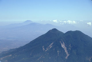
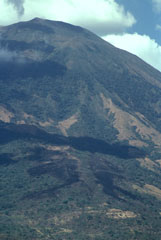
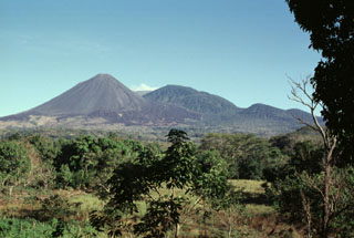
 Cerro La Olla is one of a chain of young scoria cones erupted on either side of Volcán Chingo. The southern vents, including Cerro La Olla, lie in El Salvador, while the northern vents, the largest of which is Volcán Las Viboras, are in Guatemala.
Photo by Paul Kimberly, 1999 (Smithsonian Institution).
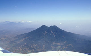
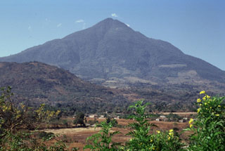
 Volcán Chingo is located along the Guatemala/El Salvador border. This aerial view is from the SW, the Guatemala side. The border with El Salvador extends from the bottom-right part of the photo through Volcán Chingo to Lake Guija at the upper left corner of the photo.
Photo by Paul Kimberly, 1999 (Smithsonian Institution).
 The basaltic lava flow in the foreground originated during a major effusive eruption that began from fissure vents on the NNW flank of San Miguel on July 25, 1844. By December lava was confined to the crater. The volcano then entered a several-year-long period of explosive activity. Another lava flow was reported in 1848, the year the eruption ended.
Photo by Paul Kimberly, 1999 (Smithsonian Institution).
 Small cinder cones on the lower SE flank of San Miguel between about 300 and 400 m altitude were constructed along a radial fissure that also was the source of a voluminous basaltic lava flow (foreground) erupted in 1819. The flow traveled about 5 km and covered a broad area below the base of the volcano.
Photo by Paul Kimberly, 1999 (Smithsonian Institution).
 The dark-colored areas at the bottom of the photo are lava flows erupted from a SSE-flank vent of San Miguel in December 1855. The larger dark area above it extending diagonally across the image is a cloud shadow. The 1855 lava flows were erupted from a SSE-trending radial fissure and were the smallest flows erupted at San Miguel in historical time, extending only about a kilometer from the vent.
Photo by Paul Kimberly, 1999 (Smithsonian Institution).
 The easternmost peak of San Vicente is seen here from the NE along the road to the city of San Vicente. The hill in the foreground (left) is Cerro Ramírez, a flank cone that is one of the most recent features of the volcanic complex.
 Photo by Paul Kimberly, 1999 (Smithsonian Institution).
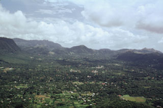
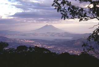 Lake Ilopango occupies the Ilopango caldera immediately east of the capital city of El Salvador, seen in the foreground. This view is from San Salvador volcano with San Vicente volcano in the background. The caldera formed during four major eruptions, the last of which was about 1,500 years ago. This eruption deposited ash and pumice over much of central and western El Salvador.
Photo by Paul Kimberly, 1999 (Smithsonian Institution).
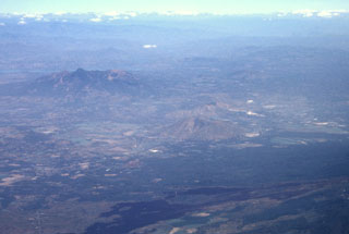 The massive Pleistocene Guazapa stratovolcano (left-center) is seen here in an aerial view from the SW with the Río Lempa behind it. The youngest flank vent of Guazapa is Cerro Macanze, which lies on the SE flank of the volcano, behind the two small volcanoes in the right-center part of the photo. The dark-colored unvegetated lava flow in the foreground was erupted in 1917 from the flank of San Salvador volcano.
Photo by Paul Kimberly, 1999 (Smithsonian Institution).
 Izalco has been one of El Salvador's most active volcanoes during historical time. More than 50 eruptions took place since it began to erupt in 1770, many lasting several years to about a decade in duration. Eruptions took place both from the summit craters and from flank vents. Unvegetated lava flows are seen here on the SE flank below Cerro Verde (center) and El Conejal and El Astillero (right).
Photo by Paul Kimberly, 1999 (Smithsonian Institution).
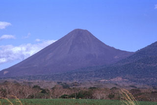 Volcán Izalco is one of El Salvador's most well-known volcanoes. It rises more than 1 km above its southern base (left) and 300 m above the saddle between it and Cerro Verde, a flank cone on Santa Ana (right). Since Izalco began erupting in 1770, the summit grew about 650 m above its original vent on the flank of Santa Ana volcano.
Photo by Paul Kimberly, 1999 (Smithsonian Institution).
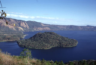 Cerro Grande is the largest of a series of post-caldera lava domes extruded along a NE-SW-trending line within Coatepeque caldera. The lava dome, seen here from the southern caldera rim, rises about 90 m above the lake surface and about 180 m above the lake floor.
Photo by Paul Kimberly, 1999 (Smithsonian Institution).
 Scoria deposits are exposed in a quarry on the NE flank of Cerro Verde along the road to its summit. Cerro Verde is the largest of a chain of scoria cones on the SE flank of Santa Ana.
 Photo by Paul Kimberly, 1999 (Smithsonian Institution).
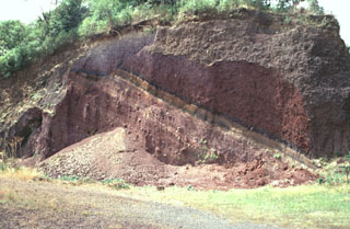
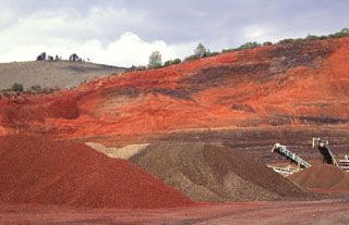
 These scoria layers from Santa Ana were transported intact with only slight disruption out to about 30 km from the volcano in the Acajutla debris avalanche. A more than 20-m-thick sequence of inter-bedded tephra layers and thin lava flows within an avalanche hummock is exposed in this quarry in near Highway 2. The red-and-yellow bars on the scale mark 10-cm increments.
Photo by Paul Kimberly, 1999 (Smithsonian Institution).
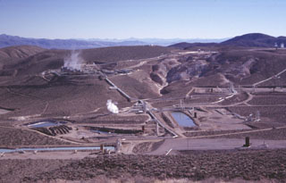
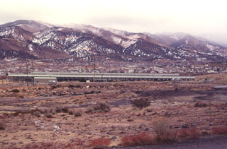 The elongated structure in the center of the photo is a power generating plant of the Steamboat Springs geothermal field. The plant is easily visible from U.S. Highway 395 and Nevada 341 south of Reno. Exploratory wells were drilled as early as the 1950s and 1960s, but the first successful well was drilled in 1979.
Photo by Paul Kimberly, 1997 (Smithsonian Institution).
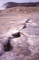 A now-inactive fissure cuts the surface of a sinter mound at Steamboat Springs in Nevada. Steam from a hot springs rises at the upper left. Steamboat Springs, an area of active geothermal development, currently displays hot springs, a large number of steam vents and fumaroles structurally related to regional faults. The area once contained about 20 small geysers, but none are currently active.
Photo by Paul Kimberly, 1997 (Smithsonian Institution).
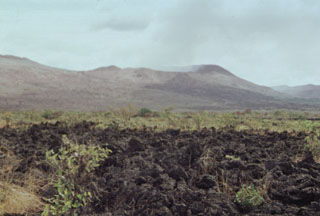
 The 70-sq-km Amboy lava field in southern California is composed mostly of vesicular pahoehoe lava flows that form a hummocky terrain with a surface relief of 2-5 m. Lava tubes are not present in the Amboy flows, which display abundant tumuli and pressure ridges. Light-colored deposits of aeolian sand, thicker to thw SW, fill depressions in the lava flow.
 Photo by Paul Kimberly, 1997 (Smithsonian Institution).
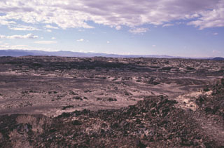
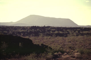
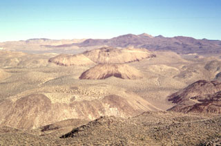
 The dark-colored area seen in the distance across the dry Lavic Lake is a cinder cone and associated lava field that is one of the young vents of the Lavic Lake volcanic field. The youthful-looking lava flows originated from the Sunshine Peak area of the Lava Beds Mountains, south of the better known Pisgah Crater.
Photo by Paul Kimberly, 1997 (Smithsonian Institution).
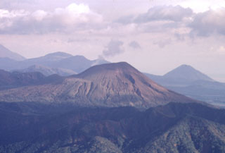
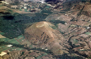
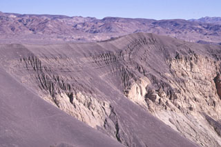
 Pisgah Crater is the most prominent feature of the Lavic Lake volcanic field, which contains four Quaternary cinder cones. The 100-m-high Pisgah Crater, seen here from the NW, and its surrounding 100-sq-km lava field are easily seen from nearby Interstate highway 40. The crater and nearby vents were the source of dominantly pahoehoe lava flows that traveled as far as 18 km NW over alluvial-fan and playa-lake deposits. Pisgah Crater was initially considered to be Holocene in age, but more recent dating indicates it is about 25,000 years old.
 Photo by Paul Kimberly, 1997 (Smithsonian Institution).
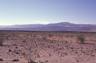
 Darker-colored layers of basaltic ash drape the northern rim of Ubehebe Crater in the northern part of Death Valley National Park and spill down the crater walls. The 235-m-deep Ubehebe Crater is the largest of a series of more than a dozen overlapping maars formed by explosive eruptions through fanglomerate deposits, which form the light-colored areas below the ash layers. The Amargosa Range rises on the horizon across Death Valley to the east.
Photo by Paul Kimberly, 1997 (Smithsonian Institution).
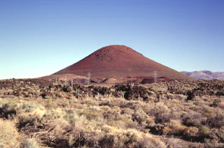 Red Cone, a basaltic cinder cone at the western margin of the Coso volcanic field, is a prominent landmark visible from Highway 395, which follows the eastern margin of the Sierra Nevada Range. The late-Pleistocene cinder cone is the largest of a group of isolated cones along the valley floor. An area of more concentrated young basaltic cones and lava flows occurs to the SE along the crest of the volcanic horst forming the Coso Range.
Photo by Paul Kimberly, 1997 (Smithsonian Institution).
 A cooperative program of the U.S. Navy China Lake Naval Weapons Station and private industry has developed geothermal power at the Coso volcanic field. The first well was drilled in 1981 and production now exceeds 250 megawatts, greatly reducing energy costs to the Navy and providing additional electricity to the southern California power grid. This view from the NW shows turbine plants and production well ponds at Coso. Devils Kitchen, a fumarolic area with extensively hydrothermally altered ground, appears at the upper right.
Photo by Paul Kimberly, 1997 (Smithsonian Institution).
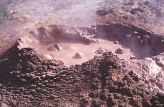 Bubbling mudpots are abundant in the Coso Hot Springs on the eastern margin of the Coso volcanic field. The hot springs occur along faults at the margins of a horst capped by rhyolitic rocks and are associated with fumaroles, mudpots, and widespread areas of hydrothermally altered ground.
Photo by Paul Kimberly, 1997 (Smithsonian Institution).
 The Coso volcanic field at the western edge of the Basin and Range province consists of largely Pliocene to late-Pleistocene rhyolitic lava domes and basaltic cinder cones covering a 400 km2 area. This view looks south across the range from Cactus Peak with some of the 38 light-colored rhyolitic lava domes of the Coso volcanic field in the foreground and dark-colored basaltic cinder cones and associated lava flows in the background. Active fumaroles and thermal springs are present in an area that is a producing geothermal field.
 Photo by Paul Kimberly, 1997 (Smithsonian Institution).
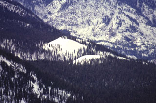 Red Cones, here mantled in winter white in a telephoto view looking SW from Mammoth Mountain, are two young basaltic cinder cones in the eastern Sierra Nevada Mountains near Devils Postpile National Monuement. The youthful-looking cones are Holocene in age.
Photo by Paul Kimberly, 1997 (Smithsonian Institution).
 The Geysers steam field is located at the SW end of the Clear Lake volcanic field in the Coast Ranges of western California. A large silicic magma reservoir provides the heat source.
Photo by Paul Kimberly, 1997 (Smithsonian Institution).
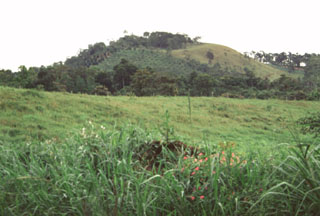
 Round Mountain, seen here from the west, rises above the floor of High Valley. Round Mountain is the northernmost of a N-S-trending chain of basaltic andesite cinder cones at the eastern end of the Clear Lake volcanic field. A lava flow from Round Mountain underlies part of the High Valley. Many of the basaltic andesite and andesitic lava flows of the Clear Lake field are contaminated with crustal materials. They often contain xenocrysts of quartz up to several cm in size that are known locally as "Lake County Diamonds."
Photo by Paul Kimberly, 1997 (Smithsonian Institution).
 Round Mountain (center), seen here from the WNW with the hills of the California Coast Range in the background, is one of a series of basaltic andesite cinder cones erupted along a N-S-trending line at the eastern margin of the Clear Lake volcanic field. These cones form some of the youngest products of the volcanic field. Lava flows from Round Mountain extend west into High Valley (lower right) and east to the North Fork Cache River. The background hills are composed of Cretaceous-Jurrasic metamorphic rocks of the Franciscan formation.
Photo by Paul Kimberly, 1997 (Smithsonian Institution).
 Brilliantly colored, bright-red oxidized scoria deposits from a cinder cone near the SE end of Clear Lake are quarried for road aggregate. The basaltic andesite cinder cone is one of a N-S-trending chain of young cones at the eastern margin of the Clear Lake volcanic field. This the northernmost of two quarried cinder cones bissected by the highway leading into the town of Clearlake Oaks.
Photo by Paul Kimberly, 1997 (Smithsonian Institution).
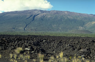 Mauna Kea is seen here from the S at the broad Humu'ulu Saddle between Mauna Kea and Mauna Loa. The lava flow in the foreground was emplaced during an 1843 eruption that originated on the NE rift zone of Mauna Loa. The flow traveled directly N to the Mauna Kea saddle, where it was deflected to the W. The irregular profile of the summit region of Mauna Kea is due to scoria cones and pyroclastic ejecta that are not present at Mauna Loa.
Photo by Paul Kimberly, 1994 (Smithsonian Institution).
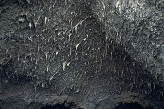 Lava stalactites are abundant on the ceiling of a 1984 fissure within the Mauna Loa Moku’aweoweo caldera. They formed when molten lava was flowing through, dripping and solidifying as they cooled. This section of the 1984 fissure erupted through the 1949 scoria cone located on the SW caldera rim.
 Photo by Paul Kimberly, 1994 (Smithsonian Institution).
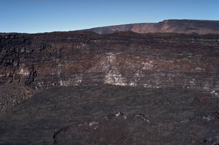 The steep walls of Lua Poholo pit crater, immediately NE of Mokuʻāweoweo caldera, expose a small portion of the accumulation of thin, overlapping lava flows that form Mauna Loa. This view from the NE shows the caldera rim to the upper right. Lava flows from recent eruptions fill crater floor, including the most recent 1984 eruption.
Photo by Paul Kimberly, 1994 (Smithsonian Institution).
 The black, newly solidified glassy surface of pahoehoe lava flows commonly has a silvery or iridescent color. Pahoehoe lavas form during eruptions that are characterized by the upwelling of hot, low-viscosity magma. This smooth-textured pahoehoe flow at Kīlauea volcano was photographed in August 1994.
 Photo by Paul Kimberly, 1994 (Smithsonian Institution).
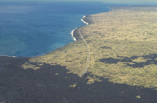 The Laeapuki lava flow on Kīlauea overran the coastal highway in April 1993, barely missing the Laeapuki ruins between the highway and the coast. After this June 1994 photo looking SW along the coast, lava flows overran the ruins. Lava flows from the East Rift Zone eruption that began in 1983 first reached the coast in 1986. By 1995 the flows had created 11 km of new coastline.
Photo by Paul Kimberly, 1994 (Smithsonian Institution).
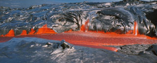
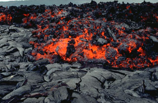 An `a`a lava flow, with a characteristic surface containing abundant angular chunks as it cools, advancing across a smooth-textured pahoehoe lava flow. The hot, incandescent flow interior is visible. The front of this 3 June 1994 flow at Laeapuki, near the Puna coast of Kīlauea volcano, is about 1 m thick.
 Photo by Paul Kimberly, 1994 (Smithsonian Institution).