Theme Collections | Sentinel Imagery
Theme collections are galleries not specifically related to volcanic hazards, processes, research, types, or features. This includes subjects such as different satellite platforms, astronaut photos from the Space Shuttle, specific photographers, or other special collections.
Image Gallery for Sentinel Imagery
This gallery present satellite images of volcanoes made available through the Copernicus Sentinel satellite system (https://sentinel.esa.int/web/sentinel/), the European Union's Earth observation program. The European Commission implements this program in partnership with the Member States, the European Space Agency (ESA), the European Organisation for the Exploitation of Meteorological Satellites (EUMETSAT), the European Centre for Medium-Range Weather Forecasts (ECMWF), EU Agencies, and Mercator Océan. The information services provided are free and openly accessible. Sentinel imagery provides a level of spatial coverage, with both visual and infrared data, that has significantly improved our ability to identify eruptive activity at volcanoes around the world. There are 101 images available.
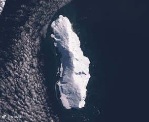
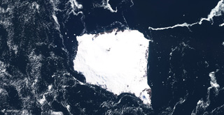
 Melville is located on the southern peninsula at the east end of King George Island, Antarctica, in the area shown in this 19 January 2020 Sentinel-2 satellite image (N is at the top; this image is approximately 9 km across).
Satellite image courtesy of Copernicus Sentinel Data, 2020.
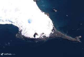
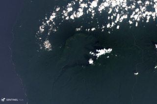
 The Pleiades volcanic group is located in Melbourne Volcanic Province of Antarctica and is shown in the center of this 8 December 2019 Sentinel-2 satellite image (N is at the top; this image is approximately 20 km across). Mt. Pleiones is in the south of the southernmost exposed area, and Mt. Atlas forms the northeastern exposed area. Features to the north include the Alcyone and Taygete cones.
Satellite image courtesy of Copernicus Sentinel Data, 2020.
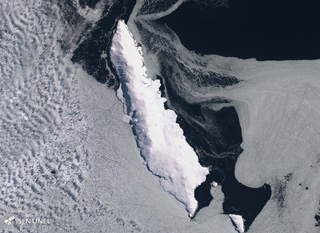
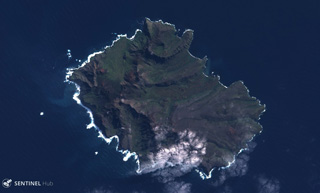
 The roughly 32-km-long Sturge Island is shown in this 3 March 2019 Sentinel-2 satellite image (N is at the top). It is the southernmost of the three main Balleny islands, with Buckle and Young to the north.
Satellite image courtesy of Copernicus Sentinel Data, 2020.
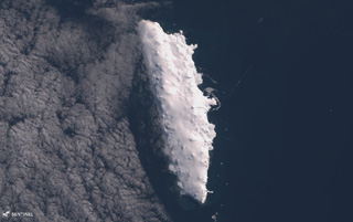
 The roughly 30-km-long Young Island is shown in this 24 January 2020 Sentinel-2 satellite image (N is at the top). It is the northernmost of the three main Balleny islands, with Buckle and Sturge to the south.
Satellite image courtesy of Copernicus Sentinel Data, 2020.
 The 21-km-long Buckle Island near Antarctica is shown in this 2 March 2019 Sentinel-2 satellite image (N is at the top). It is one of three main Balleny islands of similar size with Young to the N and Sturge S and is 110 km NNE of Belousov Point.
Satellite image courtesy of Copernicus Sentinel Data, 2019.
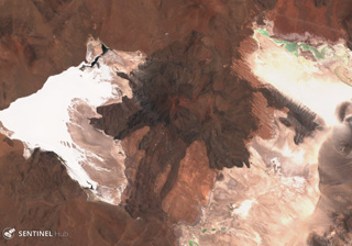
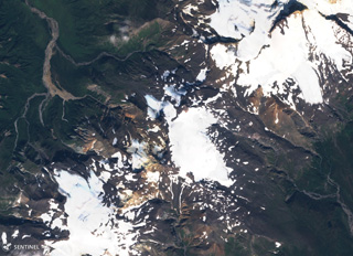
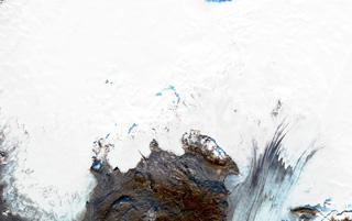 Þórðarhyrna (Thordarhyrna) is below the Vatnajökull glacier with the ice between 100-600 m thick, shown in this 29 October 2019 Sentinel-2 satellite image (N is at the top; this image is approximately 52 km across). The edifice is 15 km in diameter and is part of the Grímsvötn volcanic system. Cauldrons that have formed within the ice above indicate geothermal activity.
Satellite image courtesy of Copernicus Sentinel Data, 2019.
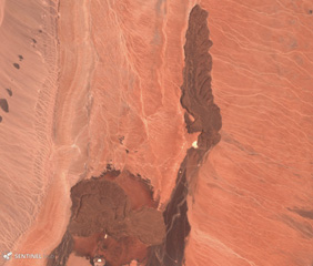
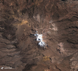
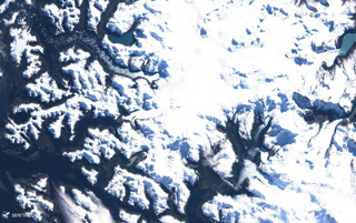 Aguilera is located in the southernmost Chilean Andes, within the area shown in this 8 September 2019 Sentinel-2 satellite image (N is at the top; this image is approximately 60 km across).
Satellite image courtesy of Copernicus Sentinel Data, 2019.
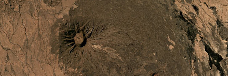
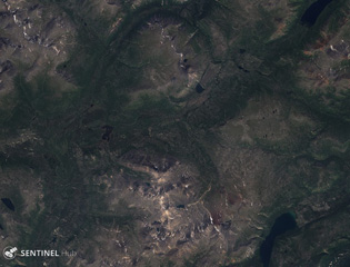
 Snezhniy volcano in the northern Sredinny Range of Kamchatka is in the center of this 27 July 2019 Sentinel-2 satellite image (N is at the top; this image is approximately 30 km across). Several large scarps are visible on the NW flank and three craters have been identified on the flanks as well as a 700-m-diameter summit crater.
Satellite image courtesy of Copernicus Sentinel Data, 2019.
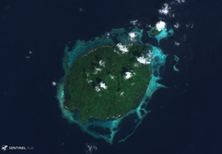
 The small Manuk island is shown in this 10 September 2019 Sentinel-2 satellite image and is located in the eastern Banda volcanic arc. While the island is small, the edifice rises about 3 km from the sea floor. There appear to be several nested craters and/or flank collapse scarps opening towards the S. Geothermal activity continues on the island.
Satellite image courtesy of Copernicus Sentinel Data, 2019.
 The 10-km-wide Prince Edward Island is around 300 km S of the SW Indian Ocean Ridge and is shown in this 24 May 2019 Sentinel-2 satellite image (N is at the top). Seven tuff cones have been identified and scoria cones have also formed across the island, as well as lava flows. A large portion of the island has been submerged through faulting.
 Satellite image courtesy of Copernicus Sentinel Data, 2019.
 This shadows captured in this Sentinel-2 satellite image acquired on 19 May 2019 (N is at the top) highlights the steep southern cliffs of Ile aux Cochons. The 10-km-wide island has preserved scoria cones with craters across the landmass.
Satellite image courtesy of Copernicus Sentinel Data, 2019.
 The glaciated 12 x 12 km Montagu Island in the South Sandwich Islands is shown in this 2 December 2019 Sentinel-2 satellite image (N is at the top). The highest point is Mount Belinda near the northern coastline with the dark crater apparent here, which appears to have formed within a 6-km-diameter, ice-filled caldera. The SE peninsula is Mount Oceanite.
Satellite image courtesy of Copernicus Sentinel Data, 2019.
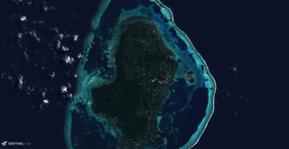 The main 7 x 14 km Uvea Island and 22 smaller islands that make up Wallis Islands are surrounded by a reef reaching approximately 18 km across (E-W), seen here in this 29 August 2018 Sentinel-2 satellite image. The island contains lava flows, craters, and scoria cones, with some craters containing lakes.
Satellite image courtesy of Copernicus Sentinel Data, 2018.
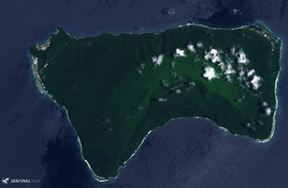
 Upolo Island in Samoa is shown in this 8 august 2018 Sentinel-2 satellite image (N is at the top; this image is approximately 70 km across). Younger monogenetic cones and craters that produced lava flows are aligned along the WNW-ESE central ridge, with some lava flows having reached the coast.
Satellite image courtesy of Copernicus Sentinel Data, 2019.
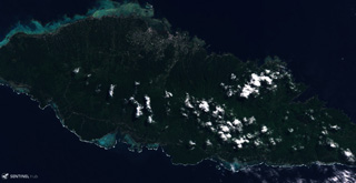
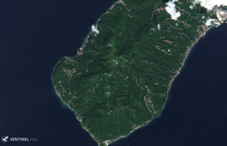
 Tutuila Island is in the center of the Samoan Islands, shown in this 3 March 2019 Sentinel-2 satellite image (N is at the top; this image is approximately 44 km across). The extensively eroded island has multiple eruptive centers that have produced domes, cones, craters, and calderas.
Satellite image courtesy of Copernicus Sentinel Data, 2019.
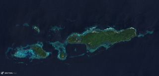
 Ofu (left) and Olosega (right) in eastern Samoa are parts of the same volcano separated by the Asaga Strait, with the island group reaching nearly 9 km across (including the smaller island to the west), shown in this 29 October 2018 Sentinel-2 satellite image (N is at the top). The islands have likely been shaped by flank failures with resulting debris avalanches below sea level.
Satellite image courtesy of Copernicus Sentinel Data, 2018.
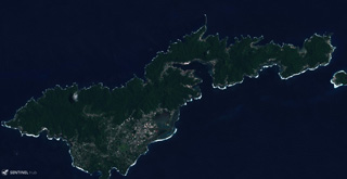
 Ta’u Island in eastern American Samoa is the exposed portion of the Lata shield volcano, seen in this 29 October 2019 Sentinel-2 satellite image (N is at the top; this image is approximately 13 km across). Smaller cones and craters have formed across the flanks, and a major flank collapse event around 22 ka resulted in the steep scarps on the southern side of the island.
Satellite image courtesy of Copernicus Sentinel Data, 2018.
 The volcanic units of Ile de la Possession largely formed between around 5 and 0.5 million years ago, shown in this 30 March 2019 Sentinel-2 satellite image (N is at the top). The island is part of the Crozet Archipelago and has been through five main cycles of eruptive activity and erosion including glacial valley formation. More recently, scoria cones and lava flows formed, as well as the collapse of part of the western flank.
Satellite image courtesy of Copernicus Sentinel Data, 2019.
 The Cerro la Torta lava dome formed on the western flank of Cerros de Tocorpuri around 34 ka, shown in this 5 November 2019 Sentinel-2 satellite image (N is at the top). The N-S length of the dome is 4 km with an areal extent of 12 km2, and a 4.7 km3 volume. The complex is located along the Chile-Bolivia border.
Satellite image courtesy of Copernicus Sentinel Data, 2019.
 The Tilocalar volcanic center is shown here in this 25 November 2019 Sentinel-2 satellite image (N is at the top), with Tilocalar Norte near the center of the image and Tilocalar Sur to the SW. Tilocalar Norte erupted a single 4.3-km-long lava flow while Tilocalar Sur produced four lava flows. They overlie the Talabre ignimbrite.
Satellite image courtesy of Copernicus Sentinel Data, 2019.
 Caichinque is between the Salar Capur (left) and Salar Talar (right) lakes, seen here in this 22 November 2019 Sentinel-2 satellite image (N is at the top). More than six vents have produced lava flows, with the one to the south reaching 6 km.
Satellite image courtesy of Copernicus Sentinel Data, 2019.
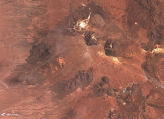 The Cerro Purico complex is shown in this 5 November 2019 Sentinel-2 satellite image (N is at the top; the image is approximately 43 km across). The dome containing white material at the top is Cerro Toco, then towards the SW is Cerro Chajnantor and Cerro Chascón. The dark lava flow to the W was erupted from Cerro Negro, then towards the SW is Cerros de Macon, Cerro Putas, and Cerro Aspero, and the edifice with the crater in the SW corner is Alitar.
Satellite image courtesy of Copernicus Sentinel Data, 2019.
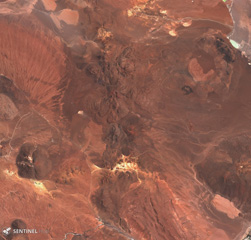 Cerros de Guayaques is the irregular 10-km-long N-S chain down the center of this 5 November 2019 Sentinel-2 satellite image, along the Chile-Bolivia border. The group consists of lava domes, and a crater near the center of the complex produced a 5-km-long lava flow to the SW and W.
Satellite image courtesy of Copernicus Sentinel Data, 2019.
 Glaciated Sara Sara volcano is in the center of this 22 July 2019 Sentinel-2 satellite image (N is at the top). A 15-km-long lava flow is visible on the eastern flank, with clear levees along the flow boundary. It is the westernmost young volcano in Peru and has produced intermittent explosive activity for less than 2 million years.
Satellite image courtesy of Copernicus Sentinel Data, 2019.
 The lava flow down the center of this 3 December 2019 Sentinel-2 satellite image (N is at the top) was erupted from the Cerro Auquihuato scoria cone at its northern terminus. The flow is approximately 10 km long and reaches a thickness of 50 m.
Satellite image courtesy of Copernicus Sentinel Data, 2019.
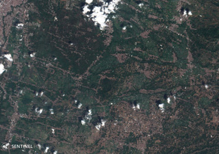
 Romeral volcano forms the area in the center of this 24 January 2018 Sentinel-2 satellite image, NE of the city of Manizales (N is at the top; the image is approximately 19 km across). It produced two Plinian pumice eruptions that blanket areas NW of the volcano, and is located at the northern end of the Ruiz-Tolima volcanic chain.
Satellite image courtesy of Copernicus Sentinel Data, 2018.
 The early Pleistocene La Reforma caldera is in the center of this 16 November 2019 Sentinel-2 satellite image (N is at the top) along the Gulf of California. The caldera is about 9 km wide, with andesitic outer flanks and a resurgent dome in the center.
Satellite image courtesy of Copernicus Sentinel Data, 2019.
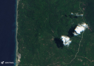
 Alligator lake is in the lower right corner of this 24 July 2018 Sentinel-2 satellite image (N is at the top; this image is approximately 31 km across). The Alligator Lake volcanic complex contains cones and lava flows with the Ibex Mountain Cone to the NW (in the center of the top of this image).
Satellite image courtesy of Copernicus Sentinel Data, 2018.
 The St. Michael volcanic field consists of more than 55 cones and craters across Stuart Island (upper left) and the peninsula in the center of this 18 August 2020 Sentinel-2 satellite image (N is at the top; this image is approximately 40 km across). The field covers more than 3,000 km2. The Stuart Hill cone is visible in the eastern side of Stuart island, and St. Michael Mountain is in the center of the peninsula area.
Satellite image courtesy of Copernicus Sentinel Data, 2019.
 Stepovak Bay 4 is part of the Stepovak Bay Group on the western Alaska Peninsula. The group is located along a NE-trending ridge, seen here in this 17 August 2019 Sentinel-2 satellite image (N is at the top), which is approximately 14 km across. Several of the volcanoes have produced debris flows and lava flows in the Holocene.
Satellite image courtesy of Copernicus Sentinel Data, 2019.
 Stepovak Bay 3 is part of the Stepovak Bay Group on the western Alaska Peninsula. The group is located along a NE-trending ridge, seen here in this 17 August 2019 Sentinel-2 satellite image (N is at the top), which is approximately 14 km across.
Satellite image courtesy of Copernicus Sentinel Data, 2019.
 Stepovak Bay 2 is part of the Stepovak Bay Group on the western Alaska Peninsula. The group is located along a NE-trending ridge, seen here in this 14 September 2018 Sentinel-2 satellite image (N is at the top), which is approximately 14 km across. Several of the volcanoes have produced debris flows and lava flows in the Holocene.
Satellite image courtesy of Copernicus Sentinel Data, 2018.
 The Dariganga Volcanic Field is SE Mongolia near the border with China and is shown in this 28 September 2019 Sentinel-2 satellite image (N is at the top). The field contains over 200 scoria cones and resulting lava flows across around 14,000 km2. This image is approximately 190 km across.
Satellite image courtesy of Copernicus Sentinel Data, 2019.
 The two edifices in this 18 September 2019 Sentinel-2 image (N is at the top) are Voyampolsky (right) and Kakhtana, both of the Voyampolsky complex, one of the northernmost volcanoes of Kamchatka. This image is approximately 22 km across.
Satellite image courtesy of Copernicus Sentinel Data, 2019.
 Snegovoy is one of the northernmost volcanoes in Kamchatka, seen here in this 5 September 2019 Sentinel-2 satellite image (N is at the top). The glaciated edifice is primarily constructed of lava flows. This image is approximately 22 km across, with Ostry volcano to the lower left.
Satellite image courtesy of Copernicus Sentinel Data, 2019.
 The broad Kebeney volcano in the central Sredinny Range, Kamchatka, is shown here in this 21 August 2019 Sentinel-2 satellite image (N is at the top). Scoria cones have formed on its flanks. This image is approximately 20 km across.
Satellite image courtesy of Copernicus Sentinel Data, 2019.
 Verkhovoy volcano is located in the central Sredinny Range and is shown in this 5 September 2019 Sentinel-2 satellite image (N is at the top). The edifice covers an area of 22 km2 and has several scoria cones. This image is approximately 14 km across.
Satellite image courtesy of Copernicus Sentinel Data, 2019.
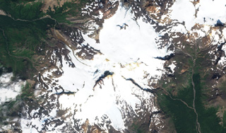
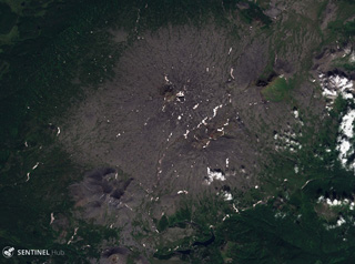
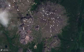
 The 12-km-diameter Uksichan summit caldera is visible in this 25 July 2019 Sentinel-2 satellite image (N is at the top). The complex includes a large shield volcano, scoria cones, lava domes, and lava flows out to 15-20 km. This image is approximately 24 km across.
Satellite image courtesy of Copernicus Sentinel Data, 2019.
 Maly Payalpan has a northern and southern peak, visible in this 27 July 2019 Sentinel-2 satellite image (N is at the top). The complex covers an area of 65 km2 and contains obsidian lava flows. This image is approximately 14 km across.
Satellite image courtesy of Copernicus Sentinel Data, 2019.
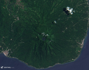
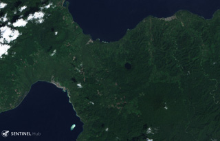
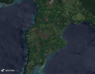
 Mount Panay is a low andesitic stratovolcano occupying the elongated Calumpang Peninsula between Balayan Bay (left) and Batangas Bay (right). It is considered to be Pleistocene in age, and has current geothermal activity.
Satellite image courtesy of Copernicus Sentinel Data, 2019.
 The Labo volcanic center in SE Luzon contains numerous lava domes and lahar deposits, and extensive geothermal activity. This 25 April 2019 Sentinel-2 satellite image (N is at the top) is approximately 10 km across and shows the summit area of the main edifice in the center.
Satellite image courtesy of Copernicus Sentinel Data, 2019.
 This 1 February 2019 Sentinel-2 satellite image (N is at the top) shows part of southern end of the 35-km-long volcanic island of Biliran, located across the narrow Biliran Strait from the northern tip of Leyte Island (left). Lava domes, craters, and geothermal areas have formed around the island.
Satellite image courtesy of Copernicus Sentinel Data, 2019.
 The Mahagnao volcanic complex is in the center of this 20 August 2018 Sentinel-2 satellite image (N is at the top), which is approximately 10 km across. The complex includes the Kasiboi and Danan cones and has current geothermal activity.
Satellite image courtesy of Copernicus Sentinel Data, 2018.
 The summit of Cabalían contains a crater lake, visible near the center of this 10 August 2019 Sentinel-2 satellite image (N is at the top) which is approximately 11 km across. The Cantoloc cone is immediately N of the main crater, and geothermal activity occurs on the eroded E and W flanks.
Satellite image courtesy of Copernicus Sentinel Data, 2019.
 Silay is the northernmost volcano on Negros Island in the Philippines and is shown in this 25 April 2019 Sentinel-2 satellite image (N is at the top), which is approximately 23 km across.
Satellite image courtesy of Copernicus Sentinel Data, 2019.
 The deeply eroded Mandalagan volcanic complex on northern Negros Island is seen here in this 25 April 2019 Sentinel-2 satellite image (N is at the top). Seven volcanic centers have been identified and geothermal activity continues. This image is approximately 23 km across.
Satellite image courtesy of Copernicus Sentinel Data, 2019.
 The Paco-Maniayao volcanic complex is located on the peninsula forming the NE tip of Mindanao and is seen here in this 15 August 2019 Sentinel-2 satellite image (N is at the top). The complex contains several craters and lava domes. This image is approximately 10 km across.
Satellite image courtesy of Copernicus Sentinel Data, 2019.
 Balatukan (also known as Balatocan) is part of the central Mindano volcanic arc in the Philippines, seen here in this 10 August 2019 Sentinel-2 satellite image (N is at the top). The edifice is deeply eroded and geothermal activity occurs in the area.
Satellite image courtesy of Copernicus Sentinel Data, 2019.
 The Latukan summit is the lighter green area near the center of this 10 August 2019 Sentinel-2 satellite image (N is at the top). Located in NW Mindanao, Makaturing volcano is W and Ragang is NE.
Satellite image courtesy of Copernicus Sentinel Data, 2019.
 An alignment of craters is visible in this 10 August 2019 Sentinel-2 satellite image (N is at the top) showing Makaturing volcano in central Mindanao. The width of this image is approximately 28 km. The summit is near the center of the image.
Satellite image courtesy of Copernicus Sentinel Data, 2019.
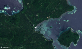
 The 1.8-km-long (N-S) arcuate lake in the center of this 15 November 2019 Sentinel-2 satellite image (N is at the top) is Lake Leonard, located within a caldera of the Leonard Range in Mindanao Island. Around the lake are a series of lava domes and active geothermal areas.
Satellite image courtesy of Copernicus Sentinel Data, 2019.
 The summit of Bukit Bibinoi (Bibinoi Hill) is about 4 km SE of the lake-filled 600-m-diameter Songa crater visible in this 11 January 2019 Senitnel-2 satellite image (N is at the top). The Bukit Lansa cone is to the NW.
Satellite image courtesy of Copernicus Sentinel Data, 2019.
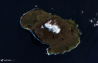
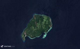
 Bukit Amasing (Amasing Hill) is the largest and NW-most of a group of three small volcanoes along a NW-SE line in central Bacan Island, and is shown in the center of this 11 April 2017 Sentinel-2 satellite image (with N to the top). The cone is approximately 6 km in diameter.
Satellite image courtesy of Copernicus Sentinel Data, 2017.
 Gunung Tigalalu is located at the northern end of Kayoa Island, west of Halmahera in Indonesia. The edifice is a N-S-trending volcanic ridge, seen down the center of this 13 September 2019 Sentinel-2 satellite image (N is at the top).
Satellite image courtesy of Copernicus Sentinel Data, 2019.
 Moti is shown in this 28 September 2018 Sentinel-2 satellite image (N is at the top). It formed along a N-S-trending chain of islands off the western coast of Halmahera Island. The island is surrounded by coral reefs and is 6-7 km in diameter.
Satellite image courtesy of Copernicus Sentinel Data, 2018.
 Mare is shown in this 28 September 2018 Sentinel-2 satellite image (N is at the top). It is part of a chain of volcanic islands alongside Halmahera, Indonesia, and is between Tidore to the north and Moti to the south. The maximum diameter of the island is approximately 4 km.
Satellite image courtesy of Copernicus Sentinel Data, 2018.
 The Jailolo volcanic complex forms a roughly 10-km-long peninsula on West Halmahera Island, seen in this 13 September 2019 Sentinel-2 satellite image. The Jailolo cone forms the center of the peninsula, and the 2-km-diameter Idamdehe caldera is to the W. To the S of the caldera are Bobo crater and Pajo and Saria (or Kailupa hill) cones.
Satellite image courtesy of Copernicus Sentinel Data, 2019.
 Todoko-Ranu in West Halmahera Island has two calderas visible in this 12 December 2019 Sentinel-2 image (N is at the top), the Ranu caldera to the north with a lake along the eastern wall, and Todoko caldera to the SW. Todoko is approximately 2 km wide.
Satellite image courtesy of Copernicus Sentinel Data, 2019.
 Two scoria cones of Tarakan volcano in northern Halmahera Island are seen here in this 22 November 2019 Sentinel-2 satellite image (N is at the top). Tarakan Lamo (on the east side of the lake) and Tarakan Itji (to the NW of Tarakan Lamo) have 800 and 500 m diameter craters, that are 160 and 125 m deep, respectively.
Satellite image courtesy of Copernicus Sentinel Data, 2019.
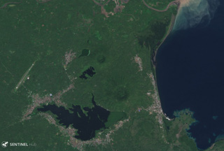
 The Malang Plain in eastern Java contains a group of cones, maars, and conduit remnants. These volcanic centers lie in a broad valley alongside Tengger caldera to the NE and Semeru to the E. The area is shown in this 4 December 2019 Sentinel-2 image, with N at the top.
Satellite image courtesy of Copernicus Sentinel Data, 2019.
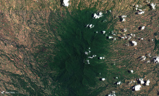
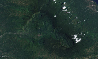
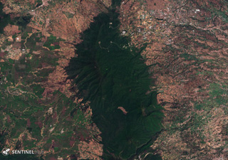 Kendang volcano is the elongate forested area down the center of this 18 November 2019 Sentinel-2 satellite image (N is at the top). The complex is an area of significant geothermal development and includes the Darajat Geothermal Field.
Satellite image courtesy of Copernicus Sentinel Data, 2019.
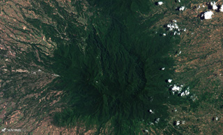
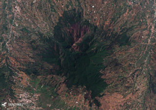 The Pleistocene Malabar volcano is shown here in this 16 November 2019 Sentinel-2 satellite image (N is at the top). It is located south of Bandung city and north of Wayang-Windu lava dome. The area in this image is approximately 15 km across.
Satellite image courtesy of Copernicus Sentinel Data, 2019.
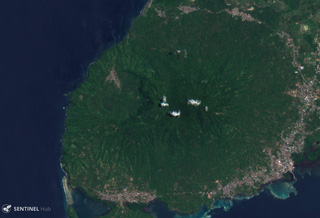
 Imun volcano is the small darker green area in the center of this 16 June 2019 Sentinel-2 satellite image (N is at the top). The cone is around 20 km S of the eastern side of Toba caldera.
Satellite image courtesy of Copernicus Sentinel Data, 2019.
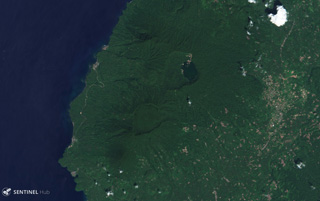
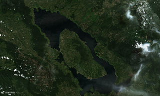 The 30 x 100 km Toba caldera formed during four major eruptions, the most recent occurring 74,000 years ago when it erupted the Young Toba Tuff. Samosir Island is an area of resurgence within the caldera, formed by uplifting of the caldera floor by at least 1.1 km over thousands of years. N is at the top of this 21 June 2019 Sentinel-2 satellite image.
Satellite image courtesy of Copernicus Sentinel Data, 2019.
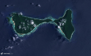
 The Dawson Strait Group encompasses a group of cones across several islands including Fergusson (upper left), Normanby (lower left), and Sanaroa (upper right) Islands in Papua New Guinea, seen in this 18 October 2019 Sentinel-2 Satellite image (N is at the top). Dobu Island to the left of Normanby has a roughly 1.5 km wide crater visible here.
Satellite image courtesy of Copernicus Sentinel Data, 2019.
 The roughly 10 x 12 km Hargy caldera is shown in this 9 January 2018 Sentinel-2 satellite image (N at the top) with Lake Hargy in the SE corner. The Galloseulo cone with its approximately 650-m-wide summit crater is also within the caldera, W of the lake.
Satellite image courtesy of Copernicus Sentinel Data, 2018.
 The Sulu Range in New Britain, Papua New Guinea spans this 25 July 2019 Sentinel-2 satellite image (N is at the top), with Mount Malopu in the center to the S, Mount Ululu and Ubia to the N, Mount Ruckenberg to the NE, and Mount Talutu dome to the SE. Kaiamu maar forms the peninsula extending about 1 km into Bangula Bay to the NW.
Satellite image courtesy of Copernicus Sentinel Data, 2019.
 The Garua Harbour volcanic field has produced features throughout much of the area shown in this 25 November 2019 Sentinel-2 satellite image (with N to the top), including the approximately 3.5-km-wide Garua Island in the lower right corner. The field includes lava domes and cones, and has geothermal features including fumaroles and geysers.
Satellite image courtesy of Copernicus Sentinel Data, 2019.
 The center of Garove Island is a lagoon likely formed through edifice collapse, with debris avalanche deposits offshore. Cones have formed across the flanks, with Peter Hafen crater along the NE coast visible in this 4 December 2019 Sentinel-2 satellite image (N is at the top; this image is approximately 15 km across).
Satellite image courtesy of Copernicus Sentinel Data, 2019.
 The Mundua islands are an E-W trending group of volcanic edifices north of New Britain, Papua New Guinea. The island group is seen here in a 4 December 2019 Sentinel-2 satellite image (N at the top) with a lateral distance of approximately 15 km. The largest island to the E is Ningau, with Goru crater on the far left side. Three smaller island-forming cones can be seen to the W of Ningau, with Silenge, then Vambu from E to W, and Undaga N of Vambu.
Satellite image courtesy of Copernicus Sentinel Data, 2019.
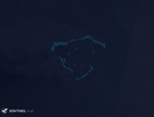 Hankow Reef is thought to be the remnant of an eroded volcanic island called Yomba that was described through oral tradition. The reef is visible in this 15 August 2019 Sentinel-2 satellite image (N is at the top) between Bagabag and Crown islands, N of the main island of Papua New Guinea.
Satellite image courtesy of Copernicus Sentinel Data, 2019.
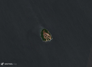
 The roughly 4.5-km-wide Baluan Island of Papua New Guinea is a Pleistocene volcano with several flank vents and a 750-m-wide summit crater visible in this 4 December 2019 Sentinel-2 satellite image (N is at the top).
Satellite image courtesy of Copernicus Sentinel Data, 2019.
 Several lava flows of the Kuh-e Nader volcanic field are visible here, located in the Nader Mountains between Taftan and Bazman volcanoes in SE Iran. Several lobate lava flow boundaries are apparent. This 3 December 2019 Sentinel-2 satellite image is approximately 18 km across (N at the top).
Satellite image courtesy of Copernicus Sentinel Data, 2019.
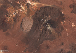
 Several maars of the Qal'eh Hasan Ali volcanic field in SE Iran are visible in this 3 December 2019 Sentinel-2 satellite image (N at the top), with the largest near the center being the 1.2-km-wide, 300-m-deep Great Crater. The field contains 14 identified maar craters.
Satellite image courtesy of Copernicus Sentinel Data, 2019.
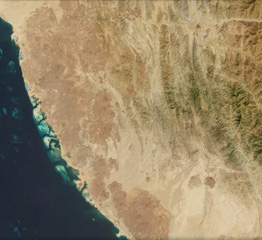 Around 200 identified scoria cones have formed throughout the 1,800 km2 Harrat al Birk volcanic field, seen along the Red Sea coast of Saudi Arabia in this 20 October 2020 Sentinel-2 satellite image (N is at the top; this image is approximately 93 km across). In the center of the top boundary of this image is two recent cones and lava flows, Jabal Ba’a and Jabal al Qishr, in the Asir mountains.
Satellite image courtesy of Copernicus Sentinel Data, 2019.
 The Kutum Volcanic Field contains many scoria cones, craters, and lava flows, seen in this 25 November 2019 Sentinel-2 satellite image (N is at the top). This image is approximately 85 km across, and is south of the larger Meidob volcanic field.
Satellite image courtesy of Copernicus Sentinel Data, 2019.
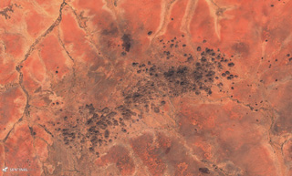
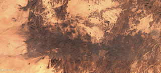
 Scoria cones, craters, and lava flows are visible across the Tarso Tôh volcanic field in this 3 December 2019 Sentinel-2 satellite image (N at the top). This field in the NW portion of the Tibesti Range of Chad contains around 150 identified volcanic centers. This image shows an area approximately 45 km across.
Satellite image courtesy of Copernicus Sentinel Data, 2019.
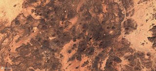 The 1,500 km2 Manzaz Volcanic Field within the Hoggar volcanic province of Algeria contains numerous generall monogenetic cones, maars, and lava flows, seen here in this 15 November 2019 Sentinel-2 satellite image (N at the top). Many scoria cones produced lava flows through the side as a flank collapsed, leaving a horseshoe-shaped edifice.
Satellite image courtesy of Copernicus Sentinel Data, 2019.
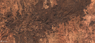 The 2,150 km2 Atakor Volcanic Field within the Hoggar volcanic province, Algeria, contains abundant scoria cones, lava domes, and lava flows, seen across this 15 November 2019 Sentinel-2 satellite image (N at the top). Erosion has also exposed intrusions and volcanic conduits from older activity.
Satellite image courtesy of Copernicus Sentinel Data, 2019.
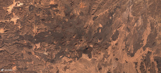
 The E-W-trending Tahalra Volcanic Field within the Hoggar Province of southern Algeria covers an area of around 1,800 km2, seen here in this 3 December 2019 Sentinel-2 satellite image (N is at the top). Numerous cones and craters are visible across the image.
Satellite image courtesy of Copernicus Sentinel Data, 2019.
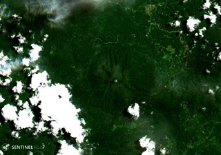
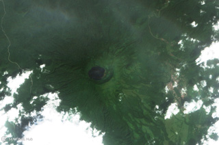
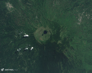 Manengouba contains the roughly 3-km wide Eboga caldera, visible in this 7 May 2019 Sentinel-2 satellite image (N at the top) around 115 km NE of Mount Cameroon. Many cones and maars have formed around the flanks, producing lava flows out to 10 km.
Satellite image courtesy of Copernicus Sentinel Data, 2019.
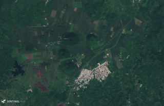 The Tombel Graben is a series of grabens that contain a monogenetic volcanic field consisting largely of scoria cones, maars, and lava flows, several of which are seen in this 13 November 2019 Sentinel-2 satellite image (N at the top). The town of Malinkam is seen here, and the larger Malinkam cone about 2 km SW is approximately 1 km wide.
Satellite image courtesy of Copernicus Sentinel Data, 2019.
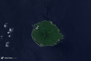
 Lago Biao fills the San Joaquin (also called Pico Biao) caldera, seen in this 26 December 2017 Sentinel-2 satellite image (N at the top). The caldera is approximately 1.5 km wide and is covered in dense forest. It is W of San Carlos, in the SE of Bioko Island in Equatorial Guinea.
Satellite image courtesy of Copernicus Sentinel Data, 2017.
 San Carlos is located in the south of Bioko Island in Equatorial Guinea and has a roughly 5.5-km-wide caldera, seen here in a 5 January 2019 Sentinel-2 satellite image (N at the top). A valley through the SW flank opens the crater towards the Atlantic Ocean.
Satellite image courtesy of Copernicus Sentinel Data, 2019.
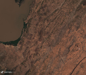
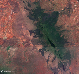 The Chyulu Hills volcanic field in southern Kenya covers an area of over 2,800 km2 and is located around 150 km E of the southern Kenya Rift Valley. More recent activity has occurred in the southern part of the field, containing a 50-km-long main central ridge with numerous cones and craters seen here in this 3 February 2019 Sentinel-2 satellite image (N at the top).
Satellite image courtesy of Copernicus Sentinel Data, 2019.
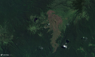
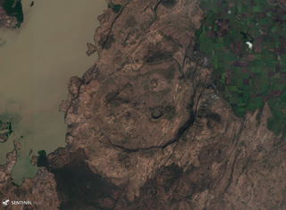
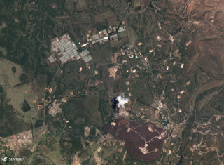 The Olkaria volcanic field contains over 80 eruption centers, some of which are visible south of Lake Naivasha in this 16 September 2019 Sentinel-2 Satellite image (N at the top). Recent activity formed the red-brown Ololbutot lava flow at the bottom of the image, which is approximately 3.5 km in the E-W direction.
Satellite image courtesy of Copernicus Sentinel Data, 2019.
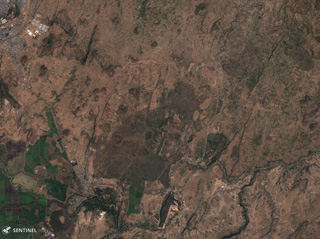
 Several scoria cones and lava flows of the Elmenteita Badlands volcanic center are visible in this 5 November 2019 Sentinel-2 satellite image (N is at the top; this image is approximately 24 km across). It contains scoria cones and lava flows of varying ages, some of which formed after the 10,000-year-old high-stand of Lake Elmenteita.
Satellite image courtesy of Copernicus Sentinel Data, 2019.
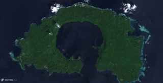
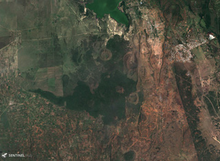
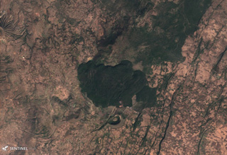
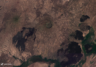
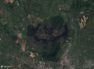 The Menengai shield volcano contains a roughly 8 x 12 km caldera with 300-m-high caldera walls, seen in this 28 November 2019 Sentinel-2 satellite image (N is at the top; this image is approximately 25 km across). Caldera formation occurred during two explosive eruptions, and since then there have been more than 70 events producing lava flows, pumice deposits, and scoria cones. The city of Nakuru lies at the bottom of the image, south of the caldera.
Satellite image courtesy of Copernicus Sentinel Data, 2019.
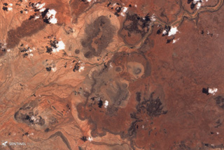 Part of the Segererua Plateau is shown in this 21 September 2019 Sentinel-2 satellite image (N is at the top; the image is approximately 23 km across). The plateau contains lava flows, maars, and craters along an area approximately 50 km in length. Several craters are visible across this image.
Satellite image courtesy of Copernicus Sentinel Data, 2019.
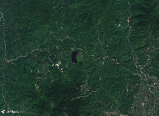
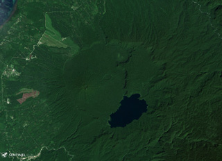
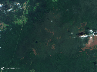 The vegetated Tepi volcanic field contains lava flows, scoria cones, and craters, located in Ethiopia, W of the Eastern Rift Valley volcanoes. Bishan Waka or Lake Kabo has filled the crater near the center of this 3 March 2019 Sentinel-2 satellite image (N is at the top; this image is approximately 16 km across).
Satellite image courtesy of Copernicus Sentinel Data, 2019.
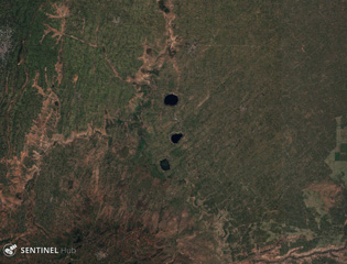 Three maars of the Bilate River Field are seen in this 31 October 2019 Sentinel-2 satellite image (N is at the top): Budamado Hayk at the top, T’ido Hayk in the middle, and Bode Ameda Hayk below. The field is within the Main Ethiopia Rift, W of Awassa. This image is approximately 29 km across.
Satellite image courtesy of Copernicus Sentinel Data, 2019.
 The East Zway (or East Ziway) volcanic field has over 50 mapped cones and maars, located E and SE of Ziway Lake in the top left of this 15 November 2019 Sentinel-2 satellite image (N is at the top; this image is approximately 21 km across). The field is within the Wonji Fault Belt in the Main Ethiopian Rift and NE-SW and NNE-SSW faults are visible here.
Satellite image courtesy of Copernicus Sentinel Data, 2019.
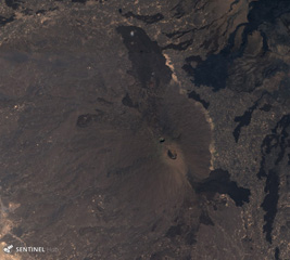
 Tullu Moje has produced both mafic and silicic eruptions, with silicic volcanism emplacing explosive deposits and thick obsidian lava flows, like the flow in the center of this 5 December 2019 Sentinel-2 satellite image (N is at the top; this image is approximately 11 km across). Immediately south of the flow is the Tullu Moje cone with a roughly 700-m-wide crater. The suspected Tullu Moje caldera is south of the Gedemsa caldera.
Satellite image courtesy of Copernicus Sentinel Data, 2019.
 The 7 x 9 km Gedemsa caldera is located along the Main Ethiopian Rift, east of Koka Lake (left), seen in this 5 December 2019 Sentinel-2 satellite image (N is at the top). The caldera has produced ignimbrites, pyroclastic surge, ashfall, and has constructed scoria cones, with a 1-km-wide crater in the eastern portion. A younger lava dome and flow are on the SW flank.
Satellite image courtesy of Copernicus Sentinel Data, 2019.
 The Melkassa volcanic field is an extensive 15 x 25 km wide group of Pleistocene and Holocene cones and lava flows within the Ethiopian Rift Valley. The darker lava flows are visible in this 10 November 2019 Sentinel-2 satellite image, NE of Gedemsa caldera (N is at the top; this image is approximately 23 km across).
Satellite image courtesy of Copernicus Sentinel Data, 2019.
 The dark rock down the center of this 26 October 2019 Sentinel-2 satellite image is a series of lava flows erupted from Hertali, located at the southern end of the Awash Plain and about 50 km NNE of Dofan volcano (N is at the top; this image is approximately 32 km across). Numerous NNE-SSW-trending faults of the Ethiopian Rift are visible along both sides of the flow.
Satellite image courtesy of Copernicus Sentinel Data, 2019.
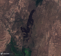
 Adwa volcano has a roughly 3 x 4 km caldera at the summit, visible near the center of this 10 November 2019 Sentinel-2 Satellite image (N is at the top). The large eroded edifice (also known as Aabida, Amoissa, or Dabita) is in the southern Afar area immediately east of Ayelu volcano, which lies above and to the left of the darker, younger SW-flank lava flows.
Satellite image courtesy of Copernicus Sentinel Data, 2019.
 Yangudi is a large eroded volcano in the Addado graben of the northern Ethiopian rift, seen here in this 15 November 2019 Sentinel-2 satellite image (N is at the top; this image is approximately 20 km across). The darker areas to the N and S are more recent lava flows and scoria cones, and numerous NNE-SSW-trending faults of the Ethiopian Rift are visible.
Satellite image courtesy of Copernicus Sentinel Data, 2019.
 Ale Bagu formed on the SW flank of Erta Ale in the Danakil rift, seen in the center of this 3 December 2019 Sentinel-2 satellite image (N is at the top; this image is approximately 17 km across). Lava flows from Erta Ale are seen in the NE of this image and lava flows from Hayli Gubbi are to the E (right).
Satellite image courtesy of Copernicus Sentinel Data, 2019.
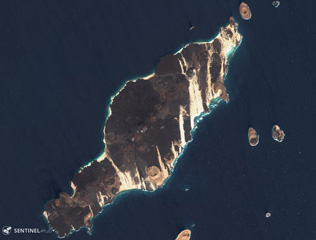 The 18-km-long island of Hanish is seen in this 3 December 2019 Sentinel-2 satellite image (N is at the top). Scoria cones and tuff cones are visible along with lava flows that have reached the coasts on all sides of the island. This island has formed during explosive phreatic eruptions with magma-water interactions, and magmatic eruptions producing lava flows. This island is approximately 18 km in the NE-SW direction.
Satellite image courtesy of Copernicus Sentinel Data, 2019.
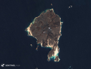 Zukur is the northern and larger island within the Zukur-Hanish island group in the southern Red Sea, seen here in this 3 December 2019 Sentinel-2 satellite image (N is at the top). Scoria cones are visible in this image, along with darker lava flows in the N, NE, and S. The island is approximately 12 km in the E-W direction.
Satellite image courtesy of Copernicus Sentinel Data, 2019.