The Kamchatkan Volcanic Eruption Response Team (KVERT) reported that a thermal anomaly over Bezymianny was identified in satellite images during 12-13 and 17-18 September; weather clouds obscured views on the other days. According to the Tokyo VAAC re-suspended that was ash deposited during previous eruptions drifted SW on 17 September. The Aviation Color Code remained at Yellow (the second lowest level on a four-color scale). Dates are reported in UTC; specific events are in local time where noted.
Sources: Kamchatkan Volcanic Eruption Response Team (KVERT), Tokyo Volcanic Ash Advisory Center (VAAC)
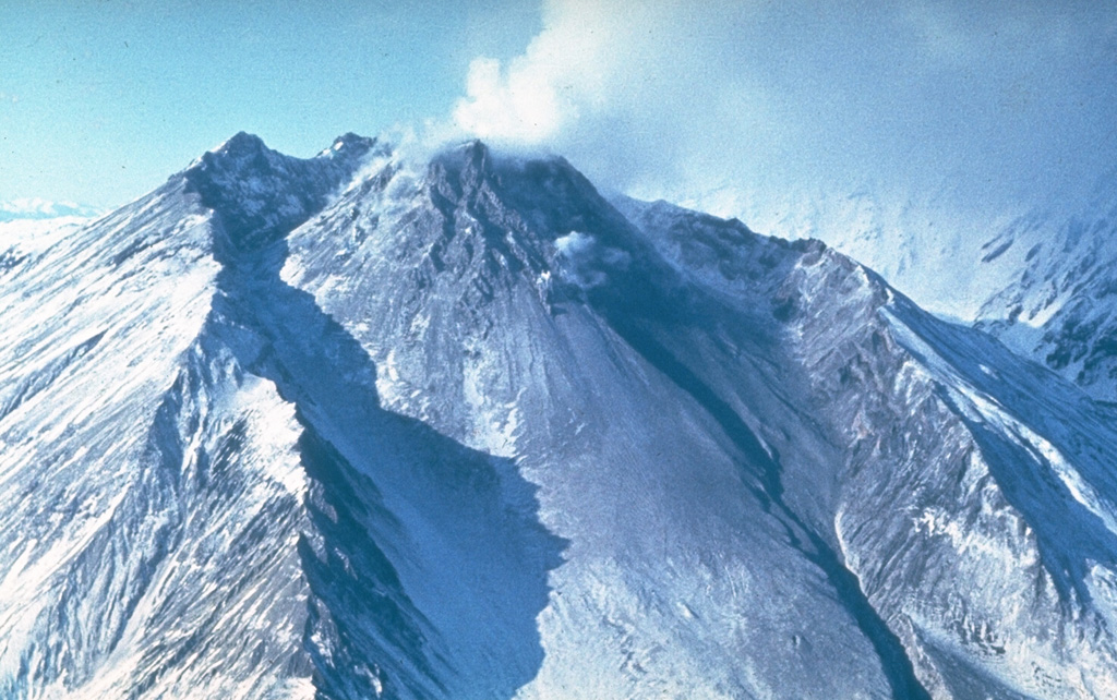
Explosion on 18 October 2023 sends ash plume 8 km high; lava flows and incandescent avalanches
Bezymianny, located on Russia’s Kamchatka Peninsula, has had eruptions since 1955 characterized by dome growth, explosions, pyroclastic flows, ash plumes, and ashfall. Activity during November 2022-April 2023 included gas-and-steam emissions, lava dome collapses generating avalanches, and persistent thermal activity. Similar eruptive activity continued from May through October 2023, described here based on information from weekly and daily reports of the Kamchatka Volcano Eruptions Response Team (KVERT), notices from Tokyo VAAC (Volcanic Ash Advisory Center), and from satellite data.
Overall activity decreased after the strong period of activity in late March through April 2023, which included ash explosions during 29 March and 7-8 April 2023 that sent plumes as high as 10-12 km altitude, along with dome growth and lava flows (BGVN 48:05). This reduced activity can be seen in the MIROVA thermal detection system graph (figure 56), which was consistent with data from the MODVOLC thermal detection system and with Sentinel-2 satellite images that showed persistent hotspots in the summit crater when conditions allowed observations. A renewed period of strong activity began in mid-October 2023.
 |
Figure 56. The MIROVA (Log Radiative Power) thermal data for Bezymianny during 20 November 2022 through October 2023 shows heightened activity in the first half of April and second half of October 2023, with lower levels of thermal anomalies in between those times. Courtesy of MIROVA. |
Activity increased significantly on 17 October 2023 when large collapses began during 0700-0830 on the E flanks of the lava dome and continued to after 0930 the next day (figure 57). Ash plumes rose to an altitude of 4.5-5 km, extending 220 km NNE by 18 October. A large explosion at 1630 on 18 October produced an ash plume that rose to an altitude of 11 km (8 km above the summit) and drifted NNE and then NW, extending 900 km NW within two days at an altitude of 8 km. Minor ashfall was noted in Kozyrevsk (45 km WNW). At 0820 on 20 October an ash plume was identified in satellite images drifting 100 km ENE at altitudes of 4-4.5 km.
 |
Figure 57. Sentinel-2 satellite images of Bezymianny from 1159 on 17 October 2023 (2359 on 16 October UTC) showing a snow-free S and SE flank along with thermal anomalies in the crater and down the SE flank. Left image is in false color (bands 8, 4, 3); right image is thermal infrared (bands 12, 11, 8A). Courtesy of Copernicus Browser. |
Lava flows and hot avalanches from the dome down the SE flank continued over the next few days, including 23 October when clear conditions allowed good observations (figures 58 and 59). A large thermal anomaly was observed over the volcano through 24 October, and in the summit crater on 30 October (figure 60). Strong fumarolic activity continued, with numerous avalanches and occasional incandescence. By the last week of October, volcanic activity had decreased to a level consistent with that earlier in the reporting period.
 |
Figure 58. Daytime photo of Bezymianny under clear conditions on 23 October 2023 showing a lava flow and avalanches descending the SE flank, incandescence from the summit crater, and a small ash plume. Photo by Yu. Demyanchuk, courtesy of IVS FEB RAS, KVERT. |
 |
Figure 59. Night photo of Bezymianny under cloudy conditions on 23 October 2023 showing an incandescent lava flow and avalanches descending the SE flank. Photo by Yu. Demyanchuk, courtesy of IVS FEB RAS, KVERT. |
 |
Figure 60. Sentinel-2 satellite images of Bezymianny from 1159 on 30 October 2023 (2359 on 29 October UTC) showing a plume drifting SE and thermal anomalies in the summit crater and down multiple flanks. Left image is in true color (bands 4, 3, 2); right image is thermal infrared (bands 12, 11, 8A). Courtesy of Copernicus Browser. |
Aviation warnings were frequently updated during 17-20 October. KVERT issued a Volcano Observatory Notice for Aviation (VONA) on 17 October at 1419 and 1727 (0219 and 0527 UTC) raising the Aviation Color Code (ACC) from Yellow to Orange (second highest level). The next day, KVERT issued a VONA at 1705 (0505 UTC) raising the ACC to Red (highest level) but lowered it back to Orange at 2117 (0917 UTC). After another decrease to Yellow and back to Orange, the ACC was reduced to Yellow on 20 October at 1204 (0004 UTC). In addition, the Tokyo VAAC issued a series of Volcanic Ash Advisories beginning on 16 October and continuing through 30 October.
Information Contacts: Kamchatka Volcanic Eruptions Response Team (KVERT), Far Eastern Branch, Russian Academy of Sciences, 9 Piip Blvd., Petropavlovsk-Kamchatsky, 683006, Russia (URL: http://www.kscnet.ru/ivs/kvert/); Kamchatka Volcanological Station, Kamchatka Branch of Geophysical Survey, (KB GS RAS), Klyuchi, Kamchatka Krai, Russia (URL: http://volkstat.ru/); Tokyo Volcanic Ash Advisory Center (VAAC), 1-3-4 Otemachi, Chiyoda-ku, Tokyo 100-8122, Japan (URL: http://ds.data.jma.go.jp/svd/vaac/data/); Hawai'i Institute of Geophysics and Planetology (HIGP) - MODVOLC Thermal Alerts System, School of Ocean and Earth Science and Technology (SOEST), Univ. of Hawai'i, 2525 Correa Road, Honolulu, HI 96822, USA (URL: http://modis.higp.hawaii.edu/); MIROVA (Middle InfraRed Observation of Volcanic Activity), a collaborative project between the Universities of Turin and Florence (Italy) supported by the Centre for Volcanic Risk of the Italian Civil Protection Department (URL: http://www.mirovaweb.it/); Copernicus Browser, Copernicus Data Space Ecosystem, European Space Agency (URL: https://dataspace.copernicus.eu/browser/).chr
2025: January
| February
| March
| April
| May
| July
| September
2024: February
| May
| June
| July
| August
| September
| October
| December
2023: February
| March
| April
| May
| October
2022: March
| April
| May
| June
| July
| August
| October
| November
| December
2020: April
| September
| October
2019: February
| March
| December
2018: April
| June
| October
2017: January
| March
| April
| May
| June
| July
| August
| September
| October
| December
2016: July
| December
2014: June
| July
| September
2013: February
2012: February
| March
| August
2011: February
| April
| September
| October
2010: February
| April
| May
| June
| September
| December
2009: June
| December
2008: July
| August
2007: April
| May
| October
| November
2006: May
| December
2005: January
| May
| November
| December
2004: January
| June
2003: July
| August
2002: January
| November
| December
2001: June
| July
| August
| December
2000: November
The Kamchatkan Volcanic Eruption Response Team (KVERT) reported that a thermal anomaly over Bezymianny was identified in satellite images during 12-13 and 17-18 September; weather clouds obscured views on the other days. According to the Tokyo VAAC re-suspended that was ash deposited during previous eruptions drifted SW on 17 September. The Aviation Color Code remained at Yellow (the second lowest level on a four-color scale). Dates are reported in UTC; specific events are in local time where noted.
Sources: Kamchatkan Volcanic Eruption Response Team (KVERT); Tokyo Volcanic Ash Advisory Center (VAAC)
The Far Eastern Branch of the Russian Academy of Sciences (FEB RAS) reported that eruptive activity at Bezymianny continued during 6-13 July. Gas-and-ash plumes rose as high as 5 km a.s.l., or around 2.1 km above the summit, and drifted W and SW during 6-7 July. Gas-and-steam plumes with possible ash content rose as high as 3.3 km a.s.l., or about 400 m above the summit, and drifted SW and W during 8-9 July. Thermal anomalies were visible during 6-10 July. Weather clouds obscured views during 10-13 July.
The Kamchatkan Volcanic Eruption Response Team (KVERT) reported that a thermal anomaly over Bezymianny was identified in satellite images during 8-15 May. According to the Institute of Volcanology and Seismology (IVS) of the Far Eastern Branch of the Russian Academy of Sciences (FEB RAS), crater incandescence was visible during dark hours on some days when weather clouds did not obscure views. Hot avalanches of material descended the flanks on 12 May. The Aviation Color Code remained at Yellow (the second lowest level on a four-color scale). Dates are reported in UTC; specific events are in local time where noted.
Sources: Kamchatkan Volcanic Eruption Response Team (KVERT); Institute of Volcanology and Seismology (IVS) of the Far Eastern Branch of the Russian Academy of Sciences (FEB RAS)
The Kamchatkan Volcanic Eruption Response Team (KVERT) reported that a thermal anomaly over Bezymianny was identified in satellite images during 1-8 May. According to the Institute of Volcanology and Seismology (IVS) of the Far Eastern Branch of the Russian Academy of Sciences (FEB RAS), crater incandescence was visible during dark hours on most days, though weather clouds mostly obscured views during 5-6 May. Hot avalanches of material descended the flanks during 1-3 May. The Aviation Color Code remained at Yellow (the second lowest level on a four-color scale). Dates are reported in UTC; specific events are in local time where noted.
Source: Kamchatkan Volcanic Eruption Response Team (KVERT)
The Kamchatkan Volcanic Eruption Response Team (KVERT) reported that an explosive eruption at Bezymianny on 23 April produced ash plumes that rose 11 km (36,100 ft) a.s.l. and pyroclastic flows that descended the Vostochnaya (E) and Yuzhnaya (S) drainages. The ash cloud drifted SW and then SE as far as 900 km during 23-25 April. Following the explosions the dome continued to erupt viscous lava and small, hot avalanches of material descended the flanks. A bright thermal anomaly was visible in satellite images through 1 May. The Aviation Color Code was lowered to Yellow (the second lowest level on a four-color scale) on 29 April.
Source: Kamchatkan Volcanic Eruption Response Team (KVERT)
The Kamchatkan Volcanic Eruption Response Team (KVERT) reported increased activity at Bezymianny and tall ash plumes on 23 April. A large thermal anomaly was visible in satellite images for several days during 17-24 April. Incandescent avalanches continued to descend the flanks. Ash clouds from the avalanches rose 4 km (13,100 ft) a.s.l. and drifted 36 km W on 20 April, rose 2.5-3 km (8,200-9,800 ft) a.s.l. and drifted 45 km WSW on 21 April, and rose up to 4 km and drifted 35 km W on 22 April.
At about 0145 on 23 April eruptive activity produced a dense ash plume that rose to 9 km (29,500 ft) a.s.l. An ash cloud, 10 x 10 km in dimension, was visible in satellite images drifting NNW. At 0351 the Aviation Color Code was raised to Red (the highest level on a four-color scale). Hot avalanches continued to descend the flanks and gas-and-steam emissions were visible. Ash was not visible in subsequent images; at 0600 on 23 April the Aviation Color Code was lowered to Orange. A stronger explosive eruption began later that day at 2310 and produced an ash plume that rose 11 km (36,100 ft) a.s.l. Satellite images showed a 36 x 26 km ash cloud drifting NNE. At 2348 the Aviation Color Code was raised to Red. The period of increased activity ended at around 0300 on 24 April. Ashfall was reported in the villages of Atlasovo, Lazo, and Milkovo. According to Kamchatka Volcanological Station (Volkstat) pyroclastic flows descended the flanks. KVERT noted that at 0510 a satellite images showed an ash cloud at altitudes of 7-7.5 km (23,000-24,600 ft) a.s.l. that was covered 110 x 175 km and had reached about 320 km SW of the volcano. At 0600 the Aviation Color Code was lowered to Orange. Dates are reported in UTC; specific events are in local time where noted.
Sources: Kamchatkan Volcanic Eruption Response Team (KVERT); Kamchatka Volcanological Station
The Kamchatkan Volcanic Eruption Response Team (KVERT) reported that a thermal anomaly over Bezymianny was identified in satellite images during 10-17 April and that there were occasional avalanches of hot material. According to the Institute of Volcanology and Seismology (IVS) of the Far Eastern Branch of the Russian Academy of Sciences (FEB RAS), incandescent debris avalanches descended mainly the E flank, and crater incandescence was often visible during dark hours. Ash plumes generated from these avalanches on most days rose as high as 3.1 km above the summit and drifted NNW, NW, W, and E. The Aviation Color Code remained at Orange (the second highest level on a four-color scale). Dates are reported in UTC; specific events are in local time where noted.
Sources: Kamchatkan Volcanic Eruption Response Team (KVERT); Institute of Volcanology and Seismology (IVS) of the Far Eastern Branch of the Russian Academy of Sciences (FEB RAS)
The Kamchatkan Volcanic Eruption Response Team (KVERT) reported that a thermal anomaly over Bezymianny was identified in satellite images during 3-10 April. According to the Institute of Volcanology and Seismology (IVS) of the Far Eastern Branch of the Russian Academy of Sciences (FEB RAS), incandescent debris avalanches descended the SE and/or E flanks, and daily crater incandescence was visible during dark hours. Ash plumes generated from these debris avalanches rose 200-1,100 m above the summit and drifted in different directions during 4-5 and 8-10 April. Lava-dome extrusion significantly increased on 11 April, causing collapses and hot avalanches of material from the E part of the dome; subsequent ash plumes rose as high as 1.1 km above the summit and drifted at least 90 km NE. The Aviation Color Code remained at Orange (the second highest level on a four-color scale). Dates are reported in UTC; specific events are in local time where noted.
Sources: Kamchatkan Volcanic Eruption Response Team (KVERT); Institute of Volcanology and Seismology (IVS) of the Far Eastern Branch of the Russian Academy of Sciences (FEB RAS)
The Kamchatkan Volcanic Eruption Response Team (KVERT) reported that a thermal anomaly over Bezymianny was identified in satellite images during 30-31 March and 1-3 April. The volcano was obscured by weather clouds on the other days of the week. According to the Institute of Volcanology and Seismology (IVS) of the Far Eastern Branch of the Russian Academy of Sciences (FEB RAS), occasional ash plumes rose as high as 1.2 km above the summit and drifted NE and E. On most days, incandescent debris avalanches descended the SE flank and summit incandescence was visible during dark hours. Weather conditions occasionally obscured webcam and satellite views. The Aviation Color Code remained at Orange (the second highest level on a four-color scale). Dates are reported in UTC; specific events are in local time where noted.
Sources: Kamchatkan Volcanic Eruption Response Team (KVERT); Institute of Volcanology and Seismology (IVS) of the Far Eastern Branch of the Russian Academy of Sciences (FEB RAS)
The Kamchatkan Volcanic Eruption Response Team (KVERT) reported that a thermal anomaly over Bezymianny was identified in satellite images during 20-27 March. According to the Institute of Volcanology and Seismology (IVS) of the Far Eastern Branch of the Russian Academy of Sciences (FEB RAS), incandescent debris avalanches descended the SE and/or E flanks and daily summit incandescence was visible during dark hours. An ash plume generated from a debris avalanche rose 100 m above the summit and drifted NE on 21 March. Weather conditions occasionally obscured webcam and satellite views. The Aviation Color Code remained at Orange (the second highest level on a four-color scale). Dates are reported in UTC; specific events are in local time where noted.
Sources: Kamchatkan Volcanic Eruption Response Team (KVERT); Institute of Volcanology and Seismology (IVS) of the Far Eastern Branch of the Russian Academy of Sciences (FEB RAS)
The Kamchatkan Volcanic Eruption Response Team (KVERT) reported that a strong thermal anomaly over Bezymianny was identified in satellite images during 13-20 March. According to the Institute of Volcanology and Seismology (IVS) of the Far Eastern Branch of the Russian Academy of Sciences (FEB RAS), incandescent debris avalanches descended the SE and/or E flanks and daily summit incandescence was visible during dark hours. Summit incandescence was less intense and debris avalanches were less frequent later in the week. Ash plumes generated from debris avalanches rose as high as 600 m above the summit and drifted in multiple directions. Weather conditions occasionally obscured webcam and satellite views. The Aviation Color Code remained at Orange (the second highest level on a four-color scale). Dates are reported in UTC; specific events are in local time where noted.
Sources: Kamchatkan Volcanic Eruption Response Team (KVERT); Institute of Volcanology and Seismology (IVS) of the Far Eastern Branch of the Russian Academy of Sciences (FEB RAS)
The Kamchatkan Volcanic Eruption Response Team (KVERT) reported that a strong thermal anomaly over Bezymianny was identified in satellite images during 6-13 March. According to the Institute of Volcanology and Seismology (IVS) of the Far Eastern Branch of the Russian Academy of Sciences (FEB RAS), incandescent debris avalanches descended the SE and/or E flanks and daily summit incandescence was visible during dark hours. The summit incandescence and debris avalanches were intense mid-week. Ash plumes generated from debris avalanches rose as high as 1.1 km above the summit and drifted mainly E, NE, and SE. Weather conditions occasionally obscured webcam and satellite views. The Aviation Color Code remained at Orange (the second highest level on a four-color scale). Dates are reported in UTC; specific events are in local time where noted.
Sources: Kamchatkan Volcanic Eruption Response Team (KVERT); Institute of Volcanology and Seismology (IVS) of the Far Eastern Branch of the Russian Academy of Sciences (FEB RAS)
The Kamchatkan Volcanic Eruption Response Team (KVERT) reported that a strong thermal anomaly over Bezymianny was identified in satellite images during 28 February-6 March. According to the Institute of Volcanology and Seismology (IVS) of the Far Eastern Branch of the Russian Academy of Sciences (FEB RAS), incandescent debris avalanches descended the SE flanks daily and summit incandescence was visible during dark hours. Ash plumes generated from debris avalanches rose as high as 2.2 km above the summit and drifted mainly E, NE, and NW. Weather conditions occasionally obscured webcam and satellite views. The Aviation Color Code remained at Orange (the second highest level on a four-color scale). Dates are reported in UTC; specific events are in local time where noted.
Sources: Kamchatkan Volcanic Eruption Response Team (KVERT); Institute of Volcanology and Seismology (IVS) of the Far Eastern Branch of the Russian Academy of Sciences (FEB RAS)
The Kamchatkan Volcanic Eruption Response Team (KVERT) reported that a strong thermal anomaly over Bezymianny was identified in satellite images during 20-28 February. According to the Institute of Volcanology and Seismology (IVS) of the Far Eastern Branch of the Russian Academy of Sciences (FEB RAS), incandescent debris avalanches descended the SE flanks and summit incandescence was visible during dark hours. Daily ash plumes generated from debris avalanches rose more than 2 km above the summit and drifted in multiple directions. Weather conditions sometimes obscured webcam and satellite views. The Aviation Color Code remained at Orange (the second highest level on a four-color scale). Dates are reported in UTC; specific events are in local time where noted.
Sources: Kamchatkan Volcanic Eruption Response Team (KVERT); Institute of Volcanology and Seismology (IVS) of the Far Eastern Branch of the Russian Academy of Sciences (FEB RAS)
The Kamchatkan Volcanic Eruption Response Team (KVERT) reported that a bright thermal anomaly over Bezymianny was identified in satellite images during 13-20 February. According to the Institute of Volcanology and Seismology (IVS) of the Far Eastern Branch of the Russian Academy of Sciences (FEB RAS) occasional ash plumes rose as high as 1.2 km above the summit and drifted E and SE. On most days, debris avalanches were visible descending the SE and E flanks during dark hours; weather conditions sometimes obscured webcam and satellite views. The Aviation Color Code remained at Orange (the second highest level on a four-color scale). Dates are reported in UTC; specific events are in local time where noted.
Sources: Kamchatkan Volcanic Eruption Response Team (KVERT); Institute of Volcanology and Seismology (IVS) of the Far Eastern Branch of the Russian Academy of Sciences (FEB RAS)
The Kamchatkan Volcanic Eruption Response Team (KVERT) reported that a thermal anomaly over Bezymianny was identified in satellite images during 6-13 February. The Aviation Color Code remained at Orange (the second highest level on a four-color scale). Dates are reported in UTC; specific events are in local time where noted.
Source: Kamchatkan Volcanic Eruption Response Team (KVERT)
The Kamchatkan Volcanic Eruption Response Team (KVERT) reported that a large thermal anomaly over Bezymianny was identified in satellite images during 1-6 February. A gas-and-steam plume drifted 13 km SW on 6 February. The Aviation Color Code remained at Orange (the second highest level on a four-color scale). Dates are reported in UTC; specific events are in local time where noted.
Source: Kamchatkan Volcanic Eruption Response Team (KVERT)
The Kamchatkan Volcanic Eruption Response Team (KVERT) reported that a large thermal anomaly over Bezymianny was identified in satellite images overnight during 30-31 January. Intense gas-and-steam emissions were also occurring. The Aviation Color Code was raised to Orange (the second highest level on a four-color scale). Satellite images on 3 February again showed a large thermal anomaly. Dates are reported in UTC; specific events are in local time where noted.
Source: Kamchatkan Volcanic Eruption Response Team (KVERT)
The Kamchatka Volcanic Eruption Response Team (KVERT) reported that the effusive eruption at Bezymianny continued during 12-19 December and was accompanied by vigorous degassing activity. A thermal anomaly was observed over the volcano in satellite imagery during the reporting period, except for on 13 and 17 December due to weather clouds. The Aviation Color Code remained at Yellow (the second level on a four-level scale). Dates are reported in UTC; specific events are in local time where noted.
Source: Kamchatkan Volcanic Eruption Response Team (KVERT)
The Kamchatkan Volcanic Eruption Response Team (KVERT) reported that a thermal anomaly over Bezymianny was identified in satellite images during 18, 20, and 22-24 October. The volcano was obscured by weather clouds on the other days of the week. The Aviation Color Code remained at Yellow (the second level on a four-color scale). Dates are reported in UTC; specific events are in local time where noted.
Source: Kamchatkan Volcanic Eruption Response Team (KVERT)
The Kamchatka Volcanic Eruption Response Team (KVERT) reported that a thermal anomaly over Bezymianny was identified in satellite images during 27-28 and 30 September. The volcano was obscured by weather clouds on the other days of the week. On 3 October a plume of resuspended ash lifted from the S flank by strong winds was visible in satellite images drifting 450 km ESE. The resuspended ash prompted KVERT to briefly raise the Aviation Color Code from Yellow to Orange (the second highest level on a four-color scale) at 2136; the Aviation Color Code was lowered back to Yellow at 0241 on 4 October. The plume was 1,400 km SE of the volcano on 4 October.
Source: Kamchatkan Volcanic Eruption Response Team (KVERT)
The Kamchatka Volcanic Eruption Response Team (KVERT) reported that a thermal anomaly over Bezymianny was identified in satellite images during 20-21 and 23-26 September. The volcano was obscured by weather clouds on the other days of the week. On 25 September a plume of resuspended ash lifted from the S flank by strong winds was visible in satellite and webcam images drifting 90 km E. The resuspended ash prompted KVERT to briefly raise the Aviation Color Code from Yellow to Orange (the second highest level on a four-color scale) at 2310; the Aviation Color Code was lowered back to Yellow at 0323 on 26 September.
Source: Kamchatkan Volcanic Eruption Response Team (KVERT)
KVERT reported that a daily thermal anomaly over Bezymianny was identified in satellite images during 1-8 August. Plumes of resuspended ash drifted 90 km SE during 3-4 August. Dates are based on UTC times; specific events are in local time where noted.
Source: Kamchatkan Volcanic Eruption Response Team (KVERT)
The Kamchatka Volcanic Eruption Response Team (KVERT) reported that the effusive eruption at Bezymianny continued during 25 July-1 August. A notable thermal anomaly was observed over the volcano in satellite imagery during the reporting period. The Aviation Color Code remained at Yellow (the second level on a four-color scale). Dates are reported in UTC; specific events are in local time where noted.
Source: Kamchatkan Volcanic Eruption Response Team (KVERT)
KVERT reported that activity at Bezymianny increased on 21 July and then escalated on 24 July. Lava-dome extrusion significantly increased on 21 July, causing collapses of the E part of the lava dome and subsequent hot avalanches of material. Activity continued and on 22 July the Aviation Color Code was raised to Orange (the third level on a four-color scale). Extrusion and collapses continued through 24 July with ash plumes continuing to rise 2-3 km a.s.l. and drift at least 70 km SW. A strong explosive eruption began at 1510 on 24 July, prompting KVERT to raise the Aviation Color Code to Red at 2002. The explosions produced a large ash plume that initially rose to 9.6 km (31,500 ft) a.s.l. and then to 12 km (39,400 ft) a.s.l.; the plume drifted 300 km ESE. Pyroclastic flows descended the flanks. By 0035 on 25 July the explosive phase had ended so the Aviation Color Code was lowered to Orange. Effusion at the lava dome continued and viscous lava extruded onto the dome’s flanks. The activity was accompanied by notable steam-and-gas emissions and the descent of hot avalanches. Ash clouds generated on 24 July were visible in satellite images drifting 2,500 km SE until 25 July and 1,800 km SW until 27 July. The Aviation Color Code was lowered to Yellow at 2317 on 28 July. Dates are based on UTC times; specific events are in local time where noted.
Source: Kamchatkan Volcanic Eruption Response Team (KVERT)
KVERT reported that lava extrusion at Bezymianny significantly increased on 21 July, causing collapses of the E part of the lava dome and subsequent hot avalanches of material. Ash plumes from the collapses rose 2-3 km a.s.l. On 22 July the Aviation Color Code was raised to Orange (the third level on a four-color scale). Activity was sustained at least through 24 July, and by then ash plumes were drifting 70 km SW. Dates and times are reported in UTC; specific events are in local time where noted.
Source: Kamchatkan Volcanic Eruption Response Team (KVERT)
KVERT reported that a thermal anomaly over Bezymianny was identified in satellite images during 6-9 and 11-13 June. Weather clouds prevented views on 10 June. Dates are UTC; specific events are in local time where noted.
Source: Kamchatkan Volcanic Eruption Response Team (KVERT)
KVERT reported that a daily thermal anomaly over Bezymianny was identified in satellite images during 31 May-6 June. According to the Tokyo VAAC an ash plume was identified in satellite images at 1350 (local time) on 5 June rising to 5.5 km (18,000 ft) a.s.l. and drifting E. The ash plume had dissipated by 1720 (local time). Dates are UTC; specific events are in local time where noted.
Sources: Kamchatkan Volcanic Eruption Response Team (KVERT); Tokyo Volcanic Ash Advisory Center (VAAC)
According to the Tokyo VAAC an ash plume from Bezymianny was identified in satellite images at 1350 on 5 June rising to 5.5 km (18,000 ft) a.s.l. and drifting E. The ash plume had dissipated by 1720.
Source: Tokyo Volcanic Ash Advisory Center (VAAC)
KVERT reported that a daily thermal anomaly over Bezymianny was identified in satellite images during 15-22 February. Dates are UTC; specific events are in local time where noted.
Source: Kamchatkan Volcanic Eruption Response Team (KVERT)
KVERT reported that a daily thermal anomaly over Bezymianny was identified in satellite images during 20-26 October. Dates are UTC; specific events are in local time where noted.
Source: Kamchatkan Volcanic Eruption Response Team (KVERT)
KVERT reported that eruptive activity at Bezymianny continued during 18-23 October. Large collapses on the E flanks of the lava dome that began on 17 October continued the next day. A VONA issued at 1616 on 18 October described continuing large collapses and subsequent ash plumes that rose 4.5-5 km (14,800-16,400 ft) a.s.l. and drifted 32 km NW. A large explosion at 1630 produced ash plumes that rose 10-11 km (32,800-36,100 ft) a.s.l. and drifted 50 km NNE, prompting KVERT to raise the Aviation Color Code to Red (the highest level on a four-color scale). According to the Kamchatka Volcanological Station, inclement weather clouds hindered views of the volcano but a roar was heard at about 1650 and a dark ash cloud was visible. KVERT noted that by 2030 the ash cloud had detached and was 250 m long and 70 km wide; the cloud continued to drift NNE at an altitude of 8 km (26,200 ft) a.s.l. At 2117 the Aviation Color Code was lowered to Orange. Within two days, the ash cloud drifted NE and then NW as far as 850 km. Minor ashfall was reported in Kozyrevsk, 45 km W. At 0820 on 20 October an ash plume was identified in satellite images drifting 100 km ENE at altitudes of 4-4.5 km (13,100-14,800 ft) a.s.l. At 0903 the Aviation Color Code was lowered to Yellow. Lava effusion continued; fumarolic activity and dome incandescence were visible.
Sources: Kamchatkan Volcanic Eruption Response Team (KVERT); Kamchatka Volcanological Station
KVERT reported that activity at Bezymianny was significantly elevated during 0700-0830 on 17 October and was characterized by large collapses on the E flanks of the lava dome based on satellite and webcam images. These collapses generated hot avalanches of material and produced ash-and-gas plumes that rose as high as 3.5 km a.s.l. and drifted 15 km NE. At 1419 the Aviation Color Code was raised to Orange (the third level on a four-color scale). Lava extrusion continued at least through 1727 and ash plumes had drifted as far as 86 km NE. All times are local.
Source: Kamchatkan Volcanic Eruption Response Team (KVERT)
KVERT reported that eruptive activity at Bezymianny was generally characterized by lava effusion, gas-and-steam emissions, and lava dome incandescence during 25 May-1 June. A daily thermal anomaly was identified in satellite images. The Aviation Color Code remained at Yellow (the second lowest level on a four-color scale). Dates are based on UTC times; specific events are in local time where noted.
Source: Kamchatkan Volcanic Eruption Response Team (KVERT)
KVERT reported that eruptive activity at Bezymianny was generally characterized by lava effusion, gas-and-steam emissions, lava dome incandescence, and hot avalanches that traveled down the flanks during 24-30 May. A persistent thermal anomaly was identified daily in satellite data. The Aviation Color Code remained at Yellow (the second lowest level on a four-color scale). Dates are based on UTC times; specific events are in local time where noted.
Source: Kamchatkan Volcanic Eruption Response Team (KVERT)
KVERT reported that activity at Bezymianny was generally characterized by gas-and-steam emissions, incandescence at the lava dome, and hot avalanches from the lava dome during 4-11 May. A daily thermal anomaly was identified daily in satellite images. The Aviation Color Code remained at Yellow (the second lowest level on a four-color scale). Dates are based on UTC times; specific events are in local time where noted.
Source: Kamchatkan Volcanic Eruption Response Team (KVERT)
KVERT reported that the ongoing eruption at Bezymianny was characterized by gas-and-steam emissions, occasional collapses at the lava dome, and hot avalanches during 20-27 April. A daily thermal anomaly was identified in satellite images. The Aviation Color Code remained at Yellow (the second lowest level on a four-color scale). Dates are based on UTC times; specific events are in local time where noted.
Source: Kamchatkan Volcanic Eruption Response Team (KVERT)
KVERT reported that a daily thermal anomaly from continuing lava effusion at Bezymianny was identified in satellite images during 14-20 April. Gas-and-steam emissions were visible and occasional collapses from the growing lava dome produced avalanches of hot material. The Aviation Color Code was lowered to Yellow (the second lowest level on a four-color scale) on 20 April because activity had declined after the strong 7-8 April explosive eruption. Dates are based on UTC times; specific events are in local time where noted.
Source: Kamchatkan Volcanic Eruption Response Team (KVERT)
KVERT reported that the eruption at Bezymianny intensified to a significant explosive phase starting from 1738 on 7 April and ending before 0906 on 8 April (local times). Based on webcam and satellite data ash plumes rose 10-12 km (32,800-39,400 ft) a.s.l. and drifted 2,800 km E. Notable amounts of ash fell at the Apakhonchich station. A daily thermal anomaly from continuing lava effusion was identified in satellite images during 8-14 April. The Aviation Color Code remained at Orange (the second highest level on a four-color scale).
Source: Kamchatkan Volcanic Eruption Response Team (KVERT)
KVERT reported an ongoing eruption at Bezymianny generally characterized by gas-and-steam emissions and occasional collapses of hot material from the flanks of the summit lava dome. A thermal anomaly over the summit persisted in satellite images during 31 March-6 April. Diffuse ash plumes drifted as far as 550 km E during 2 and 5-6 April. On 6 April volcanologists at the Kamchatka Volcanological Station (KVS) traveled to the Apakhonchich station to assess Bezymianny, take aerial photos, and install monitoring equipment. They observed frequent collapses of the crater rim and ash plumes that drifted NE towards Apakhonchich.
KVERT stated that at 1326 local time on 7 April a satellite image showed an ash plume drifting 150 km E at altitudes of 5.5-6 km (18,000-19,700 ft) a.s.l. A satellite image from 1600 local time that same day showed an ash plume extending as far as 230 km ESE. KVERT noted that ash emissions were intensifying, likely caused by hot avalanches from a growing lava dome. The Aviation Color Code was raised to Red (the highest level on a four-color scale). On 7 April KVS volcanologists traveled to Ambon to collect ash. They reported that a notable eruption began at 1730 local time, and within 20 minutes a large ash plume had risen to 10 km and drifted NW. KVERT reported that the strong explosive phase began at 1738 local time. Based on webcam and satellite data ash plumes rose 10-12 km (32,800-39,400 ft) a.s.l. and drifted SE. Explosions were clearly audible at 20 km distance and were heard for 90 minutes, according to KVS.
Significant amounts of ash fell at the Apakhonchich station, and the snow turned gray. The volcanologists had returned to KVS by the evening, and they were covered in ash. Ashfall continued until the morning of 8 April. In a Volcano Observatory Notice for Aviation (VONA) issued at a 0906 on 8 April, KVERT stated that the strong eruptive phase was over, and the Aviation Color Code was lowered to Orange. Ash plumes had drifted about 2,000 km E. The KVS team saw a lava flow on the active dome once the conditions were clear.
Sources: Kamchatkan Volcanic Eruption Response Team (KVERT); Kamchatka Volcanological Station
KVERT reported that a thermal anomaly over Bezymianny persisted in satellite images at least through 31 March, local time. On 2 April an ash plume rose 4.3 km (14,000 ft) a.s.l. and drifted SE according to the Tokyo VAAC. The Aviation Color Code remained at Orange (the second highest level on a four-color scale).
Sources: Kamchatkan Volcanic Eruption Response Team (KVERT); Tokyo Volcanic Ash Advisory Center (VAAC)
KVERT reported that at 1825 on 29 March an ash plume from Bezymianny rose as high as 6 km (19,700 ft) a.s.l. and drifted NE. The Aviation Color Code was raised to Orange (the second highest level on a four-color scale).
Source: Kamchatkan Volcanic Eruption Response Team (KVERT)
KVERT reported that during 17-23 February a daily thermal anomaly over Bezymianny was identified in satellite images. The Aviation Color Code remained at Yellow (the second lowest level on a four-color scale). Dates are based on UTC times; specific events are in local time where noted.
Source: Kamchatkan Volcanic Eruption Response Team (KVERT)
KVERT reported that during 8-15 December a daily thermal anomaly over Bezymianny was identified in satellite images. The Aviation Color Code remained at Yellow (the second lowest level on a four-color scale). Dates are based on UTC times; specific events are in local time where noted.
Source: Kamchatkan Volcanic Eruption Response Team (KVERT)
KVERT reported that during 11-17 November a daily thermal anomaly over Bezymianny was identified in satellite images. Gas-and-steam emissions were visible and occasional collapses from the growing lava dome produced avalanches of hot material. The Aviation Color Code remained at Yellow (the second lowest level on a four-color scale). Dates are based on UTC times; specific events are in local time where noted.
Source: Kamchatkan Volcanic Eruption Response Team (KVERT)
KVERT reported that during 3-10 November a daily thermal anomaly over Bezymianny was identified in satellite images. Strong fumarolic activity was visible, the lava dome continued to grow and was sometimes incandescent at night, and occasional collapses from the dome produced avalanches of hot material. The Aviation Color Code remained at Yellow (the second lowest level on a four-color scale). Dates are based on UTC times; specific events are in local time where noted.
Source: Kamchatkan Volcanic Eruption Response Team (KVERT)
KVERT reported that during 27 October-1 November a thermal anomaly over Bezymianny was identified in satellite images. Strong fumarolic activity was visible, the lava dome continued to grow and was sometimes incandescent at night, and occasional collapses from the dome produced avalanches of hot material. The activity had significantly decreased by 2 November. The Aviation Color Code was lowered to Yellow (the second lowest level on a four-color scale).
Source: Kamchatkan Volcanic Eruption Response Team (KVERT)
KVERT reported that notable activity continued after the strong explosive 23-24 October phase at Bezymianny through 27 October. Intense fumarolic activity was visible, the lava dome was incandescent at night, and collapses from the dome produced avalanches of hot material. Ash plumes from the collapses were sometimes large; on 26 October an ash cloud 10x13 km in dimension drifted 70 km E on 26 October, prompting KVERT to raise the Aviation Color Code to Orange (the second highest level on a four-color scale) the next day. Dates are based on UTC times; specific events are in local time where noted.
Source: Kamchatkan Volcanic Eruption Response Team (KVERT)
Activity at Bezymianny increased during 22-23 October characterized by incandescence at the summit, sometimes strong fumarolic activity, and an increasing temperature of a thermal anomaly identified in satellite images. KVERT raised the Aviation Color Code to Orange (the second highest level on a four-color scale). A strong explosive phase commenced and by 2340 local time on 23 October satellite images showed ash plumes rising to 10 km (32,800 ft) a.s.l. and drifting 10 km ENE. The Aviation Color Code was raised to Red. By 1005 local time on 24 October the phase was over, and the Aviation Color Code was lowered to Orange. Satellite images showed gas-and-steam plumes drifting NE and an intense thermal anomaly. The ash plumes from the day before had drifted as far as 1,915 km NE. At 2028 local time on 25 October KVERT lowered the Aviation Color Code to Yellow and noted that the intense thermal anomaly persisted. Dates are based on UTC times; specific events are in local time where noted.
Source: Kamchatkan Volcanic Eruption Response Team (KVERT)
The Tokyo VAAC reported that on 22 August an ash plume from Bezymianny was identified in a satellite image rising to 3.7 km (12,000 ft) a.s.l. and drifting NE.
Source: Tokyo Volcanic Ash Advisory Center (VAAC)
KVERT reported that a thermal anomaly over Bezymianny was identified in satellite images during 1-7 July. The Alert Level remained at Yellow (the second lowest level on a four-color scale). Dates are based on UTC times; specific events are in local time where noted.
Source: Kamchatkan Volcanic Eruption Response Team (KVERT)
KVERT reported that a thermal anomaly over Bezymianny was identified in satellite images during 26 June-1July. The Alert Level remained at Yellow (the second lowest level on a four-color scale). Dates are based on UTC times; specific events are in local time where noted.
Source: Kamchatkan Volcanic Eruption Response Team (KVERT)
KVERT reported that a thermal anomaly over Bezymianny was identified in satellite images during 17-26 June. The Alert Level was lowered to Yellow (the second lowest level on a four-color scale) on 26 June. Dates are based on UTC times; specific events are in local time where noted.
Source: Kamchatkan Volcanic Eruption Response Team (KVERT)
KVERT reported that eruptive activity at Bezymianny that continued during 10-17 June was characterized by strong fumarolic emissions, lava-dome incandescence, and hot avalanches. A daily thermal anomaly was also identified in satellite images. The Aviation Color Code remained at Orange (the second highest level on a four-color scale). Dates are based on UTC times; specific events are in local time where noted.
Source: Kamchatkan Volcanic Eruption Response Team (KVERT)
KVERT reported that eruptive activity at Bezymianny was characterized by strong fumarolic emissions, lava-dome incandescence, and hot avalanches continued during 4-9 June. A daily thermal anomaly was identified in satellite images. The Aviation Color Code remained at Orange (the second highest level on a four-color scale). Dates are based on UTC times; specific events are in local time where noted.
Source: Kamchatkan Volcanic Eruption Response Team (KVERT)
KVERT reported that after a notable explosive eruption phase occurred at Bezymianny on 28 May (local date), eruptive activity characterized by strong fumarolic emissions, lava-dome incandescence, and hot avalanches continued through 3 June. The Aviation Color Code was raised to Orange (the second highest level on a four-color scale). Dates are based on UTC times; specific events are in local time where noted.
Source: Kamchatkan Volcanic Eruption Response Team (KVERT)
KVERT reported that the eruption at Bezymianny continued, characterized by strong fumarolic emissions, lava-dome incandescence, explosions, and hot avalanches. Seismicity increased during 23-28 May. Multiple and notable collapses of hot avalanches on the E flank produced ash plumes that rose to 4-5 km (13,100-16,400 ft) a.s.l. and drifted 70-320 km in multiple directions.
Activity significantly increased on 28 May, local time. According to Kamchatka Volcanological Station (Volkstat), observers saw ash plumes from Bezymianny rising over Klyuchevsky volcano around lunchtime. The plume altitudes gradually increased and late in the evening a large, strong, explosive event occurred; ash plumes rose to 11 km (36,100 ft) a.s.l. and drifted E. According to KVERT satellite data showed ash plumes rising 10-12 km (32,800-39,400 ft) a.s.l. and drifting ESE at 1920. The Aviation Color Code was raised to Red (the highest level on a four-color scale). By 2010 the ash plumes had risen to 15 km (49,000 ft) a.s.l., and previous ash emissions had drifted 365 km SE. Volkstat observers noted that activity began to decline by about 2020 and plume altitudes did not exceed 6 km (19,700 ft) a.s.l. and drifted SE. At 2207 KVERT issued a VONA noting that the Aviation Color Code was lowered to Orange as the most intense phase of the explosive eruption had ended. Ash plumes continued to be emitted, though they rose no higher than 5 km based on webcam views. Two ash plumes were identified in satellite images; the first was drifting 212 km SE at an altitude of 9.5 km (31,200 ft) a.s.l. and the second was drifting 650 km SE at unspecified altitudes. On 29 May at 1000 gas-and-steam plumes with some ash were visible in webcam images rising as high as 4.5 km a.s.l. and drifting 45 km SE. Satellite images showed that the large ash cloud from the day before had drifted 1,635 km SE.
Sources: Kamchatkan Volcanic Eruption Response Team (KVERT); Kamchatka Volcanological Station
On 24 May KVERT reported that the effusive eruption at Bezymianny continued, characterized by strong fumarolic emissions, lava-dome incandescence, and hot avalanches. Notable hot avalanches descended the E flank. Gas-and-steam plumes with some ash content drifted 30 km NW on 24 May and 25 km NE on 25 May, at altitudes of 3-4.5 km (9,800-14,800 ft) a.s.l. The Aviation Color Code was raised to Orange (the second highest level on a four-color scale). Dates are based on UTC times; specific events are in local time where noted.
Source: Kamchatkan Volcanic Eruption Response Team (KVERT)
KVERT reported that the effusive eruption at Bezymianny continued during 8-15 April, along with incandescence at the lava dome, avalanches descending the SE flank, and steam-and-ash emissions. A daily thermal anomaly over the dome was identified in satellite images. The Aviation Color Code remained at Yellow (the second lowest level on a four-color scale). Dates are based on UTC times; specific events are in local time where noted.
Sources: Kamchatkan Volcanic Eruption Response Team (KVERT); Institute of Volcanology and Seismology (IVS) of the Far Eastern Branch of the Russian Academy of Sciences (FEB RAS)
KVERT reported that a daily thermal anomaly over Bezymianny was visible in satellite images during 2-8 April. Strong fumarolic activity, incandescence at the lava dome, and avalanches were also reported. The Aviation Color Code remained at Yellow (the second lowest level on a four-color scale). Dates are based on UTC times; specific events are in local time where noted.
Source: Kamchatkan Volcanic Eruption Response Team (KVERT)
KVERT reported that a daily thermal anomaly over Bezymianny was visible in satellite images during 26 March through 1 April. Strong fumarolic activity, incandescence at the lava dome, and avalanches were also reported. Dome collapses were detected on 25 and 31 March and ash clouds rose to 4 km (13,000 ft) a.s.l., expanding 40 km E and 20 km SW, respectively. The Aviation Color Code remained at Yellow (the second lowest level on a four-color scale). Dates are based on UTC times; specific events are in local time where noted.
Source: Kamchatkan Volcanic Eruption Response Team (KVERT)
KVERT reported that a daily thermal anomaly over Bezymianny was visible in satellite images during 18-25 March. The Aviation Color Code was lowered to Yellow (the second lowest level on a four-color scale) on 23 March. Dates are based on UTC times; specific events are in local time where noted.
Source: Kamchatkan Volcanic Eruption Response Team (KVERT)
An explosive eruption at Bezymianny began at 0310 on 15 March, producing ash plumes. KVERT raised the Aviation Color Code to Orange (the second highest level on a four-color scale). Activity intensified at 0053 on 16 March and remained elevated for about 30 minutes. During this phase pyroclastic flows descended the S, W, and N flanks, and ash plumes rose as high as 12 km (39,400 ft) a.s.l. that ultimately drifted more than 1,300 km NW and then NE. A large thermal anomaly over the volcano was visible through 18 March, indicating continuing lava-dome growth. Steam-and-gas emissions persisted though 23 March. The Aviation Color Code was lowered to yellow on 23 March.
Source: Kamchatkan Volcanic Eruption Response Team (KVERT)
According to the Tokyo VAAC an ash plume from Bezymianny was visible in satellite images at 0310 on 15 March drifting W at an altitude of 4.9 km (16,000 ft) a.s.l., signifying renewed explosive activity. By 0600 ash plumes rose to 6.1 (20,000 ft) a.s.l. and drifted S. Ash continued to be emitted through the day. The eruption intensified and at 1322 ash plumes rose to 8.2 km (27,000 ft) a.s.l. and drifted SW. Satellite images showed block-and-ash flows descended the SE flank to the base, with dense, dark brown ash plumes rising along its path. Thermal anomalies were visible at the summit and at the end of the flow. At 1750 possible ash plumes rose to 4.3 km (14,000 ft) a.s.l. and drifted W. Ash emissions continued to be visible in subsequent satellite images. Activity again intensified, and at 0110 on 16 March ash plumes rose to 11.6 km (38,000 ft) a.s.l. and drifted NE. Ash emissions continued to be detected in images through the day.
Sources: Tokyo Volcanic Ash Advisory Center (VAAC); Sentinel Hub
KVERT reported that a thermal anomaly over Bezymianny was identified in satellite images during 22-24 and 27-29 October. The N part of the lava dome was active and possibly advanced. The Aviation Color Code remained at Yellow (the second lowest level on a four-color scale).
Source: Kamchatkan Volcanic Eruption Response Team (KVERT)
Based on Tokyo VAAC notices, KVERT reported that an explosive eruption at Bezymianny began at 0822 on 22 October and produced a large ash cloud that rose as high as 9 km (29,500 ft) a.s.l. The Aviation Color Code was raised to Red, the highest level on a four-color scale. The ash cloud identified in satellite images was 100 x 200 km in size. KVERT noted that by 1519 the eruption was over. A large ash cloud was still visible, though it had dropped to lower altitudes of 5-5.5 km (16,400-18,000 ft) a.s.l. and split into a N part (57 x 105 km) and a S part (36 x 67 km). The clouds shiftied direction and drifted as far as 811 km NW and SE. The Aviation Color Code was lowered to Orange. On 23 October a thermal anomaly over the summit was identified in satellite images and growth of a lava dome was noted. The Aviation Color Code was lowered to Yellow.
Source: Kamchatkan Volcanic Eruption Response Team (KVERT)
KVERT reported that a new lava dome began growing in the summit crater of Bezymianny around 26 August. A thermal anomaly over the summit was visible during 28-31 August and on 4, 8, and 10 September. Weather clouds sometimes obscured views of the volcano. The Aviation Color Code remained at Yellow (the second lowest level on a four-color scale).
Source: Kamchatkan Volcanic Eruption Response Team (KVERT)
KVERT reported that a thermal anomaly over Bezymianny was identified in satellite images during 10-17 April. Gas-and-steam emissions persisted. The Aviation Color Code remained at Yellow (the second lowest level on a four-color scale).
Source: Kamchatkan Volcanic Eruption Response Team (KVERT)
On 1 January KVERT reported that activity at Bezymianny had significantly declined during the previous week; the temperature of the thermal anomaly identified in satellite images decreased and nighttime lava-dome incandescence was no longer visible. The Aviation Color Code was lowered to Yellow (the second lowest level on a four-color scale).
Source: Kamchatkan Volcanic Eruption Response Team (KVERT)
Activity at Bezymianny remained elevated during 13-20 December; nighttime crater incandescence, strong fumarolic emissions, and a lava flow on the W flank of the lava dome were visible. The temperature of a thermal anomaly had continued to increase. The Aviation Color Code remained at Orange (the second highest level on a four-color scale).
Source: Kamchatkan Volcanic Eruption Response Team (KVERT)
Activity at Bezymianny began to increase at the beginning of December, characterized by nighttime crater incandescence, strong fumarolic emissions, a lava flow, and gradually increasing temperatures of a satellite-detected thermal anomaly. KVERT increased the Aviation Color Code to Orange (the second highest level on a four-color scale) on 13 December.
Source: Kamchatkan Volcanic Eruption Response Team (KVERT)
KVERT reported that after a powerful explosive eruption at Bezymianny recorded on 15 March activity was characterized by growth of the W part of the lava dome, strong fumarolic activity, and dome incandescence. The Aviation Color Code was lowered to Yellow (the second lowest level on a four-color scale) on 21 March.
Source: Kamchatkan Volcanic Eruption Response Team (KVERT)
KVERT reported that a thermal anomaly over Bezymianny was identified in satellite images during 12-15 March, and intense gas-end-steam emissions continued to rise from the crater. Hot avalanches originating from the top of the lava dome were visible in webcam images at night.
Late on 15 March KVERT reported that activity continued to intensify noting that the number of hot avalanches increased and ash plumes from the avalanches drifted about 100 km SE. The temperature of the thermal anomaly also increased. The Aviation Color Code was raised to Red (the highest level on a four-color scale). Seismic data suggested that a powerful explosive eruption began at 0511 on 16 March. At 0530 webcam images recorded explosions generating ash plumes that rose as high as 15 km (49,200 ft) a.s.l. and drifted 10 km E. Thirty minutes later satellite images indicated continuing ash emissions rising to 15 km a.s.l. Ashfall was reported in Ust-Kamchatsk Village (120 km ENE) during 0650-0730. An ash plume, 79 x 65 km in dimension, was also identified drifting ENE.
Strong explosions continued to produce ash plumes on 16 March, although they were lower-altitude (5-6 km (16,400-19,700 ft) a.s.l.) and had a higher concentration of ash. The plumes drifted E. By 0930 ash plumes were rising to altitudes of 4-4.5 (13,100-14,800 ft) a.s.l.; ash plumes drifted 100 km E. A large ash plume, 120 x 130 km in dimension, continued to drift E at an altitude of 15 km. The Aviation Color Code was lowered to Orange (the second highest level on a four-color scale). By 1307 on 16 March satellite images showed ash plumes drifting 650 km E. The report noted that ashfall was likely occurring in Nikolskoye (370 km ESE) on Bering Island.
Source: Kamchatkan Volcanic Eruption Response Team (KVERT)
KVERT reported that a thermal anomaly over Bezymianny was identified in satellite images during 1-12 March. Strong gas-end-steam emissions continued to rise from the crater. Hot avalanches originating from the top of the lava dome were visible at night. The Aviation Color Code remained at Orange (the second highest level on a four-color scale).
Source: Kamchatkan Volcanic Eruption Response Team (KVERT)
KVERT reported that a thermal anomaly over Bezymianny was identified in satellite images during 28 February-1 March. Strong gas-and-steam emissions continued to be visible. The Aviation Color Code remained at Orange (the second highest level on a four-color scale).
Source: Kamchatkan Volcanic Eruption Response Team (KVERT)
On 27 February KVERT reported increased activity at Bezymianny characterized by nighttime crater incandescence, hot avalanches originating from the lava dome, and occasionally strong fumarolic activity. The report noted that the temperature of the thermal anomaly was gradually increasing. The Aviation Color Code was raised to Orange (the second highest level on a four-color scale).
Source: Kamchatkan Volcanic Eruption Response Team (KVERT)
KVERT reported that a thermal anomaly over Bezymianny was identified in satellite images during 20 and 22-25 October. Gas-and-steam emissions continued to rise from the crater. The Aviation Color Code remained at Yellow (the second lowest level on a four-color scale).
Source: Kamchatkan Volcanic Eruption Response Team (KVERT)
KVERT reported that a thermal anomaly over Bezymianny was identified in satellite images during 22-29 June. The Aviation Color Code remained at Yellow.
Source: Kamchatkan Volcanic Eruption Response Team (KVERT)
KVERT reported that a thermal anomaly over Bezymianny was identified in satellite images during 29-30 March and 2-3 April. The Aviation Color Code remained at Yellow.
Source: Kamchatkan Volcanic Eruption Response Team (KVERT)
On 29 December KVERT reported that activity at Bezymianny was characterized by moderate gas-and-steam emissions; a lava flow likely continued to effuse onto the N flank of the lava dome. A thermal anomaly over the volcano was identified in satellite images. The Aviation Color Code was lowered to Yellow.
Source: Kamchatkan Volcanic Eruption Response Team (KVERT)
KVERT reported that ash plumes from the 20 December explosive eruption at Bezymianny rose as high as 15 km (49,200 ft) a.s.l. and drifted 320 km NE. A thermal anomaly over the volcano was identified in satellite images during 21-22 December. The Aviation Color Code remained at Orange.
Source: Kamchatkan Volcanic Eruption Response Team (KVERT)
On 18 December hot avalanches on the SE flank of Bezymianny’s lava dome were recorded by a webcam, prompting KVERT to raise the Aviation Color Code to Orange (the second highest level on a four-color scale). A strong explosion that started at 1555 on 20 December generated ash plumes that rose 10-15 km (32,800-49,200 ft) a.s.l., prompting KVERT to raise the Aviation Color Code to Red. Ash plumes were identified in satellite data drifting 85 km NE. Later that day satellite images indicted decreased activity; the Alert level was lowered back to Orange.
Source: Kamchatkan Volcanic Eruption Response Team (KVERT)
On 6 October KVERT reported that a thermal anomaly at Bezymianny was identified in satellite images during 1-2 and 4-5 October, and that lava probably continued to flow down the W flank of the dome. The Aviation Color Code was lowered to Yellow (the second lowest level on a four-color scale).
Source: Kamchatkan Volcanic Eruption Response Team (KVERT)
KVERT reported that during 22-29 September lava continued to flow down the W flank of Bezymianny's dome, and incandescence from the dome was visible at night. The Aviation Color Code remained at Orange (the second highest level on a four-color scale).
Source: Kamchatkan Volcanic Eruption Response Team (KVERT)
KVERT reported that during 15-22 September lava continued to flow down the W flank of Bezymianny's dome, and incandescence from the dome was visible at night. A thermal anomaly was identified in satellite images during 15-19 September. The Aviation Color Code remained at Orange (the second highest level on a four-color scale).
Source: Kamchatkan Volcanic Eruption Response Team (KVERT)
KVERT reported that during 8-15 September a lava flow continued to move down the W flank of Bezymianny's dome, and incandescence from the dome was visible at night. A thermal anomaly was identified in satellite images during 8-9 and 12-13 September. The Aviation Color Code remained at Orange (the second highest level on a four-color scale).
Source: Kamchatkan Volcanic Eruption Response Team (KVERT)
KVERT reported that during 1-8 September a thermal anomaly over Bezymianny was identified daily in satellite images. A lava flow continued to flow down the W flank of the dome; incandescence from the dome was visible at night. The Aviation Color Code remained at Orange (the second highest level on a four-color scale).
Source: Kamchatkan Volcanic Eruption Response Team (KVERT)
KVERT reported that during 28-30 August a thermal anomaly over Bezymianny was identified in satellite images. A lava flow continued to flow down the W flank of the dome; incandescence from the dome was visible at night. The Aviation Color Code remained at Orange (the second highest level on a four-color scale).
Source: Kamchatkan Volcanic Eruption Response Team (KVERT)
KVERT reported that during 18-25 August a daily thermal anomaly over Bezymianny was identified in satellite images. A lava flow continued to flow down the W flank of the dome; incandescence from the dome was visible at night. The Aviation Color Code remained at Orange (the second highest level on a four-color scale).
Source: Kamchatkan Volcanic Eruption Response Team (KVERT)
KVERT reported that during 11-18 August a daily thermal anomaly over Bezymianny was identified in satellite images. A lava flow continued to flow down the W flank of the dome; incandescence from the dome was visible at night. The Aviation Color Code remained at Orange (the second highest level on a four-color scale).
Source: Kamchatkan Volcanic Eruption Response Team (KVERT)
KVERT reported that during 4-11 August a daily thermal anomaly was identified over Bezymianny in satellite images. A lava flow continued to flow down the W flank of the dome; incandescence from the dome was visible at night. The Aviation Color Code remained at Orange (the second highest level on a four-color scale).
Source: Kamchatkan Volcanic Eruption Response Team (KVERT)
KVERT reported that during 28 July-4 August a daily thermal anomaly was identified over Bezymianny in satellite images. A lava flow continued to flow down the W flank of the dome. The Aviation Color Code remained at Orange (the second highest level on a four-color scale).
Source: Kamchatkan Volcanic Eruption Response Team (KVERT)
KVERT reported that during 21-28 July a thermal anomaly was identified daily over Bezymianny in satellite images. A lava flow continued to flow down the W flank of the dome. The Aviation Color Code remained at Orange (the second highest level on a four-color scale).
Source: Kamchatkan Volcanic Eruption Response Team (KVERT)
KVERT reported that during 14-21 July a thermal anomaly was identified daily over Bezymianny in satellite images. A lava flow continued to move down the W flank of the dome. The Aviation Color Code remained at Orange (the second highest level on a four-color scale).
Source: Kamchatkan Volcanic Eruption Response Team (KVERT)
KVERT reported that a thermal anomaly was identified over Bezymianny daily in satellite images. A lava flow continued to flow down the W flank of the dome. The Aviation Color Code remained at Orange (the second highest level on a four-color scale).
Source: Kamchatkan Volcanic Eruption Response Team (KVERT)
KVERT reported that incandescence from Bezymianny's lava dome was observed at night during 1-7 July, and a lava flow continued to flow down the W flank of the dome. A thermal anomaly was identified daily in satellite images. The Aviation Color Code remained at Orange (the second highest level on a four-color scale).
Source: Kamchatkan Volcanic Eruption Response Team (KVERT)
KVERT reported that incandescence from Bezymianny's lava dome was observed at night during 23-30 June, and a lava flow continued to flow down the W flank of the dome. A thermal anomaly was identified daily in satellite images. The Aviation Color Code remained at Orange (the second highest level on a four-color scale).
Source: Kamchatkan Volcanic Eruption Response Team (KVERT)
KVERT reported that a powerful explosion at Bezymianny on 16 June generated an ash plume that rose as high as 12 km (39,400 ft) a.s.l. and drifted 700 km E and SE. Nighttime incandescence from the lava dome was observed at night afterwards, and a lava flow emerged from the W flank of the dome. A thermal anomaly was identified daily in satellite images during 16-23 June. The Aviation Color Code remained at Orange (the second highest level on a four-color scale).
Source: Kamchatkan Volcanic Eruption Response Team (KVERT)
On 15 June KVERT reported that the temperature of a thermal anomaly identified in satellite images had increased, and that the webcam recorded a gas-and-steam plume rising above Bezymianny to 4 km (13,100 ft) a.s.l. and drifted SSE. Hot avalanches of material originated from the lava dome. An explosive event began at 1653 on 16 June, producing an ash cloud 28 x 25 km in size that drifted NE. The Aviation Color Code was raised to Red (the highest level on a four-color scale), but lowered back down to Orange about 5 hours later. At 2110 the ash cloud was 212 x 115 km in size and drifting E; the leading edge of the cloud was about 245 km E.
Source: Kamchatkan Volcanic Eruption Response Team (KVERT)
On 26 May KVERT reported that after an explosive eruption at Bezymianny on 9 March, and the effusion of several lava flows onto the dome flanks, the volcano became quiet. Gas-and-steam emissions continued, along with a thermal anomaly identified in satellite images. The Aviation Color Code was lowered to Yellow (the second lowest level on a four-color scale).
Source: Kamchatkan Volcanic Eruption Response Team (KVERT)
KVERT reported gas-and-steam activity at Bezymianny during 12-19 May, and a thermal anomaly identified in satellite images daily. The Aviation Color Code remained at Orange (the second highest level on a four-color scale).
Source: Kamchatkan Volcanic Eruption Response Team (KVERT)
KVERT reported gas-and-steam activity at Bezymianny during 5-12 May, and a thermal anomaly identified in satellite images during 5 and 8-9 May. The Aviation Color Code remained at Orange (the second highest level on a four-color scale).
Source: Kamchatkan Volcanic Eruption Response Team (KVERT)
KVERT reported gas-and-steam activity at Bezymianny during 28 April-5 May, and a daily thermal anomaly identified in satellite images. The Aviation Color Code remained at Orange (the second highest level on a four-color scale).
Source: Kamchatkan Volcanic Eruption Response Team (KVERT)
KVERT reported gas-and-steam activity at Bezymianny during 21-28 April, and a daily thermal anomaly identified in satellite images. The Aviation Color Code remained at Orange (the second highest level on a four-color scale).
Source: Kamchatkan Volcanic Eruption Response Team (KVERT)
KVERT reported that during 14-21 April lava continued to advance down the NW flank of Bezymianny's lava dome. A thermal anomaly was identified in satellite images during 14-17 April. The Aviation Color Code remained at Orange.
Source: Kamchatkan Volcanic Eruption Response Team (KVERT)
KVERT reported that during 7-14 April lava continued to advance down the NW flank of Bezymianny's lava dome. A thermal anomaly was identified in satellite images daily. The Aviation Color Code remained at Orange.
Source: Kamchatkan Volcanic Eruption Response Team (KVERT)
KVERT reported that during 1-6 April lava continued to advance down the NW flank of Bezymianny's lava dome. A thermal anomaly was identified in satellite images daily. The Aviation Color Code remained at Orange.
Source: Kamchatkan Volcanic Eruption Response Team (KVERT)
KVERT reported that during 24-31 March lava continued to advance down the NW flank of Bezymianny's lava dome. A thermal anomaly was identified daily in satellite images. The Aviation Color Code remained at Orange.
Source: Kamchatkan Volcanic Eruption Response Team (KVERT)
KVERT reported that during 17-24 March lava continued to advance down the NW flank of Bezymianny's lava dome. A thermal anomaly was visible in satellite images on 17, 19, and 22 March. The Aviation Color Code remained at Orange.
Source: Kamchatkan Volcanic Eruption Response Team (KVERT)
KVERT reported that lava continued to advance down Bezymianny's NW flank during 10-17 March, and gas-and-steam plumes rose from the crater. A thermal anomaly was visible each day in satellite images. The Aviation Color Code remained at Orange.
Source: Kamchatkan Volcanic Eruption Response Team (KVERT)
KVERT reported that an explosive eruption at Bezymianny began at about 1330 on 9 March. Based on webcam observations, at 1454 an ash plume rose to altitudes of 6-7 km (20,000-23,000 ft) a.s.l. and drifted 20 km NE. The Aviation Color Code was raised to Orange (the second highest level on a four-color scale). About 30 minutes later, at 1523, an ash plume rose to altitudes of 7-8 km (23,000-26,200 ft) a.s.l. and drifted 60 km NW. KVERT raised the Aviation Color Code to Red. Satellite data showed a 14-km-wide ash plume drifting 112 km NW at an altitude of 7 km (23,000 ft) a.s.l. Later that day a 274-km-long ash plume identified in satellite images drifted NW at altitudes of 4-4.5 km (13,100-14,800 ft) a.s.l.; the majority of the leading part of the plume contained a significant amount of ash. A lava flow traveled down the NW part of the lava dome. The Aviation Color Code was lowered to Orange. Ash plumes drifted as far as 500 km NW.
Source: Kamchatkan Volcanic Eruption Response Team (KVERT)
KVERT reported strong gas-and-steam emissions at Bezymianny during 6-13 January, and a thermal anomaly over the volcano during 8-10 and 12 January. On 13 January KVERT noted that activity had gradually decreased after an intensification during 5-24 December 2016, though a thermal anomaly remained visible. The Aviation Color Code was lowered to Yellow.
Source: Kamchatkan Volcanic Eruption Response Team (KVERT)
KVERT reported strong gas-and-steam emissions at Bezymianny during 31 December 2016-6 January 2017 and a daily thermal anomaly over the volcano. The Aviation Color Code remained at Orange.
Source: Kamchatkan Volcanic Eruption Response Team (KVERT)
KVERT reported strong gas-and-steam emissions at Bezymianny during 23-30 December and a daily thermal anomaly over the volcano. The Aviation Color Code remained at Orange.
Source: Kamchatkan Volcanic Eruption Response Team (KVERT)
KVERT reported strong gas-and-steam emissions at Bezymianny during 16-23 December; a gas-and-steam plume drifted about 60 km SW on 18 December. A daily thermal anomaly was detected over the volcano. The Aviation Color Code remained at Orange.
Source: Kamchatkan Volcanic Eruption Response Team (KVERT)
KVERT reported that lava-dome extrusion likely continued at Bezymianny during 14-16 December. A gas-and-steam plume containing a small amount of ash drifted about 118 km W on 15 December. The Tokyo VAAC noted that ash plumes rose as high as 6.1 km (20,000 ft) a.s.l. that same day. The Aviation Color Code remained at Orange.
Sources: Kamchatkan Volcanic Eruption Response Team (KVERT); Tokyo Volcanic Ash Advisory Center (VAAC)
Based on KBGS RAS (Kamchatka Branch of Geophysical Services, Russian Academy of Sciences) data, KVERT noted that seismicity at Bezymianny began to increase on 18 November. The temperature of a thermal anomaly detected in satellite images increased on 5 December, and then significantly increased on 13 December, which was likely caused by lava-dome extrusion. The Aviation Color Code was raised to Orange.
Source: Kamchatkan Volcanic Eruption Response Team (KVERT)
Based on information from the Yelizovo Airport (UHPP), the Tokyo VAAC reported that on 30 July an ash plume from Bezymianny rose to an altitude of 3 km (10,000 ft) a.s.l. drifted E. The Aviation Color Code level remained at Yellow.
Sources: Tokyo Volcanic Ash Advisory Center (VAAC); Kamchatkan Volcanic Eruption Response Team (KVERT)
KVERT maintained Alert Level Yellow during the week of 12 September for Bezymianny. Weak seismic activity continued, and according to video data, moderate gas and steam activity occurred, although the volcano was frequently obscured by clouds. Satellite data showed a weak thermal anomaly over the volcano during 4-5 and 11 September.
Source: Kamchatkan Volcanic Eruption Response Team (KVERT)
KVERT maintained Alert Level Yellow during the week of 5 September for Bezymianny. Weak seismic activity continued, and according to video data, moderate gas and steam activity frequently occurred, although the volcano was obscured by clouds. Satellite data showed a weak thermal anomaly over the volcano during this reporting period.
Source: Kamchatkan Volcanic Eruption Response Team (KVERT)
KVERT reported that during 19-25 July weak seismicity and moderate fumerolic activity were observed at Bezymianny. Satellite data showed a thermal anomaly over the volcano all week. On 17 July the Aviation Color Code was lowered to Yellow.
Source: Kamchatkan Volcanic Eruption Response Team (KVERT)
KVERT reported that during 11-18 July, weak seismicity and weak to moderate gas-and-steam emissions were observed at Bezymianny. On 17 July satellite data showed a thermal anomaly over the volcano, but the view was obscured by clouds other days. The Aviation Color Code remained at Orange.
Source: Kamchatkan Volcanic Eruption Response Team (KVERT)
KVERT reported that Bezymianny’s activity continued during 2-10 July; shallow earthquakes were registered. Satellite data showed the volcano frequently obscured by clouds. The Aviation Color Code remained at Orange.
Source: Kamchatkan Volcanic Eruption Response Team (KVERT)
KVERT reported that Bezymianny’s activity continued during25-29 June; shallow earthquakes were registered. Video data captured weak gas-and-steam plumes rising from the volcano. Satellite data showed the volcano was frequently obscured by clouds. The Aviation Color Code remained at Orange.
Source: Kamchatkan Volcanic Eruption Response Team (KVERT)
KVERT reported that Bezymianny’s activity gradually increased during the week; shallow earthquakes were registered. Video data captured moderate gas-and-steam plumes rising from the volcano. Satellite data showed a thermal anomaly over the lava dome on 12, 16, and 18 June. The Aviation Color Code remained at Orange.
Source: Kamchatkan Volcanic Eruption Response Team (KVERT)
KVERT reported that seismicity at Bezymianny increased on 17 June, when about 12 shallow events were recorded that were thought to be caused by extrusion of material at the top of the lava dome. A thermal anomaly was also identified using satellite data. The Aviation Color Code was raised from Yellow to Orange.
Source: Kamchatkan Volcanic Eruption Response Team (KVERT)
KVERT reported that during 1-8 February seismic activity at Bezymianny was obscured by strong seismicity at Tolbachik. A viscous lava flow continued to effuse on the lava-dome flank, accompanied by gas-and-steam emissions. A thermal anomaly was detected in satellite imagery on 31 January and 1 February; cloud cover prevented views on the other days.
Source: Kamchatkan Volcanic Eruption Response Team (KVERT)
KVERT reported that seismic activity at Bezymianny had increased in the middle of August. During 24-31 August levels were moderate; 17 events were recorded on 28 August and 71 events were recorded on 31 August. Observers noted weak-to-moderate fumarolic activity during 25-26 and 29 August; cloud cover prevented observations on the other days. A thermal anomaly was detected in satellite imagery on 25 August.
Based on seismic data analyses, an explosive eruption occurred from 0716 to 0745 on 2 September. Ash plumes rose to altitudes of 10-12 km (32,800-39,400 ft) a.s.l. and drifted more than 1,500 km ENE. A thermal anomaly observed in satellite imagery was very bright before the explosion. The Aviation Color Code was raised to Orange, then Red. Ash plumes rose to an altitude of 4 km (13,100 ft) a.s.l. and drifted NE later that day, then ash emissions ceased. Ash plumes continued to be detected in satellite imagery and drifted 450-600 km ENE and SE. The Aviation Color Code was lowered to Yellow. On 3 September seismic activity was low. A viscous lava flow effused on the lava-dome flank, and was accompanied by fumarolic activity and hot avalanches.
Source: Kamchatkan Volcanic Eruption Response Team (KVERT)
KVERT reported that a strong explosive eruption from Bezymianny was detected by seismic instruments on 9 March. Ash plumes rose to altitudes of 3.5-5 km (11,500-16,400 ft) a.s.l. and drifted NE. During the most intense phase of the eruption ash plumes from pyroclastic flows rose to an altitude of 8 km (26,200 ft) a.s.l. Satellite imagery showed the plume drifting 700 km NE. Ashfall was reported in Ust-Kamchatsk Village (120 km ENE). Later that day activity decreased significantly and the Aviation Color Code was lowered to Orange. During 9-13 March strong gas-and-steam emissions were noted, a viscous lava flow effused onto the lava-dome flank, and a thermal anomaly continued to be detected in satellite imagery. The Aviation Color Code was lowered to Orange on 14 March.
Source: Kamchatkan Volcanic Eruption Response Team (KVERT)
KVERT reported that during 24 February-2 March seismic activity at Bezymianny remained elevated, with about 7-19 weak events registered daily. A thermal anomaly was detected in satellite images. Gas-and-steam activity was observed on 26 February; clouds obscured the volcano on the other days. One short volcanic tremor episode was detected on 29 February. About 40 seismic events were detected on 1 March and, according to satellite data analysis, the size and brightness of a thermal anomaly abruptly increased on 2 March. The Aviation Color Code was raised to Red. During 2-5 March there were 25-40 weak seismic events detected; cloud cover prevented observations of the volcano.
Source: Kamchatkan Volcanic Eruption Response Team (KVERT)
KVERT reported high levels of seismic activity at Bezymianny during 17-24 February and a thermal anomaly that was detected daily in satellite images. Two short volcanic tremor episodes were reported on 15 and 22 February. Gas-and-steam plumes, observed in satellite images, drifted NE on 20 and 22 February. The Aviation Color Code remained at Orange.
Source: Kamchatkan Volcanic Eruption Response Team (KVERT)
KVERT reported that seismic activity increased at Bezymianny on 12 February and remained elevated through 19 February. The size and brightness of a thermal anomaly observed in satellite images both increased during this interval. Blocks possibly extruded from the top of the lava dome. KVERT raised the Aviation Color Code to Orange on 19 February.
Source: Kamchatkan Volcanic Eruption Response Team (KVERT)
KVERT reported that during 21-28 October seismic activity at Bezymianny was low. A thermal anomaly was observed in satellite imagery during 23-25 October, and fumarolic activity was observed during 23 and 25-26 October. The Aviation Color Code remained at Yellow.
Source: Kamchatkan Volcanic Eruption Response Team (KVERT)
KVERT reported that during 9-15 September seismic activity at Bezymianny was low. An observer in the area on 6 September noted that lava continued to effuse on the SSE flank. The Aviation Color Code remained at Yellow.
Source: Kamchatkan Volcanic Eruption Response Team (KVERT)
KVERT reported that during 22-29 April a bright thermal anomaly on Bezymianny was detected in satellite imagery. A gas-and-steam plume that drifted 27 km NW was also detected on 22 April. According to ground-based observations, gas-and-steam activity was noted during 22 and 24-25 April. The Aviation Color Code was lowered to Yellow.
Source: Kamchatkan Volcanic Eruption Response Team (KVERT)
In addition to producing ashfall 45 km to the NNW on 14 April, KVERT reported that the explosive eruption from Bezymianny also generated a viscous lava flow on the SE flank. Incandescence from the lava flow was visible on 19 April. Satellite imagery showed a thermal anomaly during 15-22 April, and small ash-and-gas plumes on 16 April. The Aviation Color Code remained at Orange.
Source: Kamchatkan Volcanic Eruption Response Team (KVERT)
KVERT reported that seismic data suggesting a strong explosive eruption from Bezymianny began at 0820 on 14 April and lasted for 40 minutes. The Aviation Color Code level was raised to Red. Ash fell in Krasny Yar (45 km to the NNW). Cloud cover prevented observations. No activity was observed in satellite imagery; ash plumes may have been below meteorological clouds observed around 8 km a.s.l. The Aviation Color Code level was lowered to orange the next day.
Source: Kamchatkan Volcanic Eruption Response Team (KVERT)
KVERT reported that during 1-11 April seismicity from Bezymianny increased. Gas-and-steam activity was observed during 1-2 April; clouds obscured views on the other days. A thermal anomaly over the volcano observed in satellite imagery was weak during 1-3 and 6 April, then increased in size and became more intense. The Aviation Color Code was raised to Orange.
Source: Kamchatkan Volcanic Eruption Response Team (KVERT)
KVERT reported that during 28 January-4 February seismicity from Bezymianny did not exceed background levels, however weak volcanic earthquakes were detected. A thermal anomaly over the volcano was observed daily in satellite imagery. Gas and steam activity was observed during 30-31 January and 1-3 February; cloud cover prevented observations on the other days. The Aviation Color Code level remained at Yellow.
Based on information from the Yelizovo Airport (UHPP), the Tokyo VAAC reported that on 4 February an ash plume rose to an altitude of 4.6 km (15,000 ft) a.s.l. drifted NE.
Sources: Tokyo Volcanic Ash Advisory Center (VAAC); Kamchatkan Volcanic Eruption Response Team (KVERT)
KVERT reported that during 24-30 December seismicity did not exceed background levels. The temperature of thermal anomalies observed in satellite imagery during 23-24 and 27-28 December gradually increased. Gas-and-steam emissions were seen on 27 and 28 December; clouds prevented observations on the other days. The Aviation Color Code level remained at Yellow.
Source: Kamchatkan Volcanic Eruption Response Team (KVERT)
KVERT reported that, based on air photos taken of Bezymianny by helicopter on 21 November, a new area of lava possibly had extruded from the top of the lava dome. During 3-10 December seismicity did not exceed background levels. On 3 and 7 December gas-and-steam emissions were seen, the same days a weak thermal anomaly was detected in satellite imagery. The Aviation Color Code level remained at Yellow.
Source: Kamchatkan Volcanic Eruption Response Team (KVERT)
KVERT reported that a thermal anomaly over Bezymianny was observed in satellite imagery on 29 August and 1 September. Gas-and-steam activity was also noted on 1 September. Cloud cover prevented observations of the volcano on the other days during 27 August-3 September. The Aviation Color Code level remained at Yellow.
Source: Kamchatkan Volcanic Eruption Response Team (KVERT)
KVERT reported that although clouds prevented views of Bezymianny during 4-11 June, thermal anomalies were seen in satellite imagery during 4-5 and 8 June. The Aviation Color Code level remained at Yellow.
Source: Kamchatkan Volcanic Eruption Response Team (KVERT)
KVERT reported that after an explosive eruption from Bezymianny on 1 June two bright thermal anomalies on the flanks were seen in satellite imagery during 1-2 June, possibly from pyroclastic flow deposits. On 4 June KVERT noted that strong gas-and-steam emissions continued to rise from the lava dome. The Aviation Color Code level was lowered to Yellow.
Source: Kamchatkan Volcanic Eruption Response Team (KVERT)
KVERT reported that some earthquakes were detected in the vicinity of Bezymianny's lava dome during 23-24 May, even though much of the seismicity was obscured by strong activity from Kliuchevskoi. Fumarolic activity was seen on 21 May. The temperature of the thermal anomaly detected in satellite imagery increased from 18 degrees Celsius on 19 May to 48.8 degrees Celsius on 23 May. The Aviation Color Code level was raised to Orange. During 21-28 May satellite data showed a variable but daily thermal anomaly over the lava dome. Fumarolic activity was occasionally detected, and another seismic event was recorded on 24 May.
Seismic data indicated that an explosive eruption began on 1 June, producing a large ash cloud about 127 by 93 km in dimension. The Aviation Color Code level was raised to Red. Further analyses showed that ash plumes from two explosions rose to altitudes of 8-10 km (26,200-32,800 ft) a.s.l. and drifted at first 250 km W and then 160 km N and NE. Ashfall was reported in Kozyrevsk village, 45 km W. Two bright thermal anomalies were seen in satellite imagery, possibly from pyroclastic flow deposits. The next day, strong gas-and-steam emissions rose from the lava dome. The Aviation Color Code level was lowered to Orange.
Source: Kamchatkan Volcanic Eruption Response Team (KVERT)
KVERT reported that during clear weather at Bezymianny during 8-13 April moderate fumarolic activity was observed and satellite data showed a weak thermal anomaly over the lava dome. The Aviation Color Code level remained at Yellow.
Source: Kamchatkan Volcanic Eruption Response Team (KVERT)
KVERT reported that during 5-12 February a thermal anomaly from Bezymianny's lava dome was detected in satellite imagery. On 6 February a new hot lava flow from the lava dome was observed. Fumarolic activity was observed on 7 and 9 February. The Aviation Color Code level was lowered to Yellow.
Source: Kamchatkan Volcanic Eruption Response Team (KVERT)
KVERT reported that during 29-30 January and 2 February a thermal anomaly from Bezymianny's lava dome was detected in satellite imagery. The anomaly was larger during 7-8 February, prompting KVERT to raise the Level of Aviation Color Code to Orange. Strong activity from Kliuchevskoi volcano had obscured seismic signals from Bezymianny since 4 January.
Source: Kamchatkan Volcanic Eruption Response Team (KVERT)
KVERT reported that during 21-23 December a large and intense thermal anomaly from Bezymianny was detected in satellite imagery. During 22-24 December seismic activity was elevated and fumarolic activity was observed. Gas-and-steam plumes rose to an altitude of 4 km (13,100 ft) a.s.l. The Level of Aviation Color Code remained at Yellow.
Source: Kamchatkan Volcanic Eruption Response Team (KVERT)
KVERT reported that seismic activity from Bezymianny increased on 8 December. After a significant thermal anomaly was detected in satellite imagery on 17 December, the Level of Aviation Color Code was raised to Red. A few hours later a large explosive eruption produced ash plumes that were seen drifting as far as 350 km W and NW in satellite imagery. Ash plumes likely rose to altitudes greater than 10 km (32,800 ft) a.s.l.; clouds in the area prevented visual observations. Ashfall up to 3 mm thick was noted in Kozyrevsk, 45 km W, and other surrounding villages. The Level of Aviation Color Code was lowered to Orange after seismic activity significantly decreased. On 18 December another large thermal anomaly was seen over the volcano and on the SE flank. Gas-and-steam activity was also noted. During 19-20 December, a thermal anomaly continued to be detected in satellite imagery. KVERT lowered the Level of Aviation Color Code to Yellow on 21 December.
Source: Kamchatkan Volcanic Eruption Response Team (KVERT)
Reports from KVERT since August 2008 have indicated continuing dome growth and weak fumarolic activity at Bezymianny, with thermal anomalies visible in satellite data when the volcano was visible. Over the previous month such anomalies were seen on 21 and 30 May, and 2-4, 7, and 11-14 June.
Source: Kamchatkan Volcanic Eruption Response Team (KVERT)
KVERT reported that seismic activity at Bezymianny was slightly above background levels during 14 and 16-18 August and at background levels during 15 and 20-21 August. Analysis of satellite imagery revealed a thermal anomaly over the lava dome during 14-15 and 18-21 August. The thermal anomaly enlarged just before an explosion on 19 August. The explosion produced an ash plume that rose to an altitude of 9 km (29,500 ft) a.s.l. and drifted 1,200 km W. Staff at a seismic station about 50 km W reported ashfall and the smell of volcanic gas. The Level of Concern Color Code was lowered to Yellow.
Source: Kamchatkan Volcanic Eruption Response Team (KVERT)
Based on observations of satellite imagery, KVERT reported that a thermal anomaly detected over Bezymianny's lava dome was strong during 9-14 August. Seismic activity was slightly above background levels during 10-14 August, possibly indicating that hot avalanches occurred. The Level of Concern Color Code remained at Orange.
Based on observations of satellite imagery and information from KEMSD, the Tokyo VAAC reported that on 19 August, an eruption plume rose to an altitude of 7.9 km (26,000 ft) a.s.l. and drifted W.
Sources: Tokyo Volcanic Ash Advisory Center (VAAC); Kamchatkan Volcanic Eruption Response Team (KVERT)
Based on observations of satellite imagery, KVERT reported that a thermal anomaly detected over Bezymianny's lava dome grew in area and intensified during 9-11 August. Based on interpretations of seismic data, four hot avalanches occurred on 10 August and nine occurred on 11 August. On 12 August, the level of Concern Color Code was raised to Orange.
Source: Kamchatkan Volcanic Eruption Response Team (KVERT)
KVERT reported that seismic activity at Bezymianny was above background levels on 20 July and at background levels the other days during 18-25 July. Fumarolic activity was observed during 18-22 July and area volcanologists reported that the lava dome continued to grow. Weak thermal anomalies over the lava dome were detected in satellite imagery on 18, 19, and 20 July. KVERT lowered the level of Concern Color Code to Yellow.
Source: Kamchatkan Volcanic Eruption Response Team (KVERT)
KVERT reported that intermittent volcanic tremor at Bezymianny was detected on 11 July and seismic activity was above background levels during 11-16 July. Weak thermal anomalies over the lava dome were detected in satellite imagery on 11 and 15 July. Hot avalanches were reported by local observers on 15 July. The level of Concern Color Code remained at Orange.
Source: Kamchatkan Volcanic Eruption Response Team (KVERT)
Increased seismicity at Bezymianny was reported by KVERT on 12 July 2008, when the Level of Concern Color Code was raised to Orange. Intermittent volcanic tremor was recorded on 11 July, along with observations of hot avalanches and strong fumarolic activity. Weak thermal anomalies were detected in satellite imagery.
Source: Kamchatkan Volcanic Eruption Response Team (KVERT)
Based on reports from KVERT, the Washington VAAC reported an ash plume from Bezymianny at an altitude of 4.3 km (14,000 ft) a.s.l. on 2 December. Ash was not identified on satellite imagery. The level of Concern Color Code remained at Yellow.
Sources: Washington Volcanic Ash Advisory Center (VAAC); Kamchatkan Volcanic Eruption Response Team (KVERT)
KVERT reported that possibly high-temperature gas-and-steam plumes from Bezymianny along with a thermal anomaly at the summit were visible on satellite imagery on 9 November. A viscous lava flow effused from the summit. During an overflight on the same day, 4-km-long pyroclastic flow deposits from 5 November were observed on the SE flank. Lava flow-front collapses from older lava flows on the SE flank were also evident. The level of Concern Color Code was raised to Orange on 10 November.
Source: Kamchatkan Volcanic Eruption Response Team (KVERT)
Based on seismic interpretation, KVERT reported that a series of explosions or collapses from lava flow fronts at Bezymianny occurred on 5 November. Two avalanches and an ash plume were also detected. Observations of satellite imagery revealed a thermal anomaly over the lava dome. The level of Concern Color Code remained at Yellow.
Source: Kamchatkan Volcanic Eruption Response Team (KVERT)
KVERT reported that seismic activity at Bezymianny was slightly elevated during 16-19 October and returned to background levels during 19-20 October. Based on observations of satellite imagery, a strip of ash deposits was noted on the ESE flank on 18 October and a thermal anomaly was present in the crater during 16-20 October. On 20 October, KVERT lowered the level of Concern Color Code to Yellow.
Source: Kamchatkan Volcanic Eruption Response Team (KVERT)
During 5-12 October, KVERT reported that seismic activity at Bezymianny was at background levels. Based on observations of satellite imagery, a thermal anomaly was present in the crater on 4, 6, 8, and 11 October. Fumarolic activity was observed during 6-7 and 10-11 October. Based on seismic interpretation, a hot avalanche probably occurred on 10 October.
Based on observations of satellite imagery and seismic interpretation, a small eruption occurred on 15 October. Ash plumes drifted SE and a strong thermal anomaly was present in the crater. Based on information from KEMSD and observations of satellite imagery, the Tokyo VAAC reported that an ash plume rose to altitudes of 7.3-9.1 km (24,000-30,000 ft) a.s.l. and drifted E and SE. The level of Concern Color Code was raised from Yellow to Red.
No ash plumes were present on 16 October, and seismicity was only slightly above background levels. The level of Concern Color Code was lowered to Orange.
Sources: Tokyo Volcanic Ash Advisory Center (VAAC); Kamchatkan Volcanic Eruption Response Team (KVERT)
KVERT reported on 17 May that the Level of Concern Color Code for Bezymianny was lowered to Yellow. Satellite imagery showed that the thermal anomaly decreased in size during 15-17 May. Hunters reported that a large mudflow, 200 m in width, moved along the Sukhaya Khapitsa river on 17 May.
Source: Kamchatkan Volcanic Eruption Response Team (KVERT)
KVERT reported on 11 May that the level of Concern Color Code for Bezymianny was raised to Orange due to a large thermal anomaly noted on satellite imagery. During 0330-0400 on 12 May, an explosive eruption may have occurred according to seismic data from Kozyrevsk. Ash plumes were visible on satellite imagery drifting multiple directions. Ashfall was reported from the town of Klyuchi, about 47 km NE. A slight amount of the ash originated from Kliuchevskoi, an active volcano directly N of Bezymianny. Hot avalanches were observed and an ash plume rose to an altitude of 4 km (13,100 ft) a.s.l. On 13 May, an elongated thermal anomaly was seen on satellite imagery to the SE of the lava dome.
Source: Kamchatkan Volcanic Eruption Response Team (KVERT)
Based on [a pilot report to the] Petropavlovsk-Kamchatsky Flight Information Region (FIR) [at 0725], the Tokyo VAAC reported that on 29 April an ash plume from Bezymianny rose to an altitude of 6.1 km (20,000 ft) a.s.l. and drifted W. [Ash was not seen in MTSAT-IR satellite data about 26 minutes prior to the pilot report.]
[Later information regarding this reported event provided by KVERT noted that no satellite data reviewed by volcanologists contained ash plumes, there were no strong seismic events, and no explosions were seen on the video camera. Meteorological clouds were present at 4.5-5.0 km altitude overnight and through 0900 local time. No ash fell in the village of Kozyrevsk, which would have been expected had an ash plume drifted W.]
Sources: Kamchatkan Volcanic Eruption Response Team (KVERT); Tokyo Volcanic Ash Advisory Center (VAAC)
Based on aerial observations, KVERT reported on 29 December that part of Bezymianny's lava dome was destroyed during explosive activity on 24 December. Moderate fumarolic activity was observed during 26-27 December and seismic activity was at background levels during 26-29 December. The level of Concern Color Code was lowered to Yellow.
Source: Kamchatkan Volcanic Eruption Response Team (KVERT)
The level of Concern Color Code for Bezymianny was raised from Yellow to Orange on 24 December due to an increase in incandescent avalanches, seismicity, and the intensity of a thermal anomaly at the summit. Within a few hours, a series of ash explosions and "ash avalanches" produced plumes that rose to altitudes of 6-10 km (19,700-32,800 ft) a.s.l. and drifted NE. The level of Concern Color Code was raised to Red. On 25 December, KVERT reported that seismic activity returned to background levels and explosive activity ceased. The level of Concern Color Code was returned to Orange.
Source: Kamchatkan Volcanic Eruption Response Team (KVERT)
Following an explosive eruption at Bezymianny on 9 May, seismicity was at background levels on 10 May. In addition, fumarolic plumes were observed and lava flows probably extended from the lava dome. On 11 May the Concern Color Code at Bezymianny was reduced from Orange to Yellow. On 12 May, seismicity remained at background levels and gas-and-steam plumes were visible.
Source: Kamchatkan Volcanic Eruption Response Team (KVERT)
During 28 April to 5 May, Bezymianny's lava dome continued to grow. Seismicity was above background levels during 30 April to 3 May. Incandescent avalanches were visible on 4 May. At the lava dome, fumarolic activity occurred and thermal anomalies were visible on satellite imagery. Bezymianny was at Concern Color Code Yellow, which meant an explosive eruption was possible in the following 4 weeks. On 7 May the Concern Color Code was raised to Orange due to an increase in seismicity and the number of incandescent avalanches (14 occurred on 6 May in comparison to 4-6 during the previous 2 days). Intense fumarolic activity occurred, with occasional small amounts of ash. KVERT reported that an explosive eruption was possible in the next 1 or 2 weeks. On 9 May around 1935, the Concern Color Code was raised to Red, the highest level, due to increased seismicity and incandescent avalanches. A gas plume rose higher than 7 km (23,000 ft) a.s.l. and a strong thermal anomaly was visible on satellite imagery. An explosive eruption was expected in the next 1 or 2 days.
An explosive eruption occurred at Bezymianny on 9 May during 2121 to 2145. The explosion produced an ash column that rose to a height of ~15 km (49,200 ft) a.s.l. A co-ignimbrite ash plume was about 40 km in diameter and mainly extended NE of the volcano. On 10 May around 0100, seismicity returned to background levels and the Concern Color Code was reduced to Orange. Small fumarolic plumes were observed during the early morning of the 10th and lava probably began to flow at the lava dome.
Source: Kamchatkan Volcanic Eruption Response Team (KVERT)
After an explosive eruption at Bezymianny on 30 November, seismic activity at the volcano decreased to background levels. On 2 December the Concern Color Code was reduced from Orange to Yellow. On 9 December, KVERT reported that based on past experience with Bezymianny, a viscous lava flow was probably active at the summit lava dome and there were no indications that an explosive eruption was imminent.
Source: Kamchatkan Volcanic Eruption Response Team (KVERT)
Seismic data indicated an explosive eruption at Bezymianny on 30 November. Ash plumes were subsequently seen in satellite imagery extending SW at an altitude of about 6 km (19,700 ft) a.s.l. The Concern Color Code was raised to Orange.
Source: Kamchatkan Volcanic Eruption Response Team (KVERT)
Weak gas-and-steam plumes were observed on 6-7 May, but clouds frequently obscure the volcano. A thermal anomaly at the dome was detected in satellite imagery on 6-8, 10, and 12 May. Bezymianny remained at Concern Color Code Yellow.
Source: Kamchatkan Volcanic Eruption Response Team (KVERT)
KVERT lowered the Concern Color Code at Bezymianny from Red (the highest level) to Orange on 12 January when seismic activity returned to background levels following the eruption of 11 January. As seismicity remained at background levels, the Concern Color Code was lowered on 14 January from Orange to Yellow.
Source: Kamchatkan Volcanic Eruption Response Team (KVERT)
KVERT raised the Concern Color Code at Bezymianny from Yellow to Orange on 7 January as seismicity at the volcano increased. On 11 January, the Concern Color Code was raised from Orange to Red (the highest level). According to seismic data, an explosive eruption of the volcano began at 2002 on 11 January and was inferred to have produced an ash column to 8-10 km a.s.l. No visual or satellite data were available as dense clouds obscured the volcano. Seismic activity was above background levels during the past week and increased continuously. About 60 earthquakes of magnitude 1.25-2.25, and numerous weaker, shallow events registered during 7-11 January. Intermittent volcanic tremor was recorded on 10 January.
Source: Kamchatkan Volcanic Eruption Response Team (KVERT)
An eruption at Bezymianny produced an ash cloud that during 18-19 June extended more than 1,000 km E and SE from the volcano and possible ash deposits extended 190 km SE from the lava dome. Seismicity at Bezymianny did not exceed background levels during 20-23 June. The Concern Color Code at Bezymianny was reduced from Orange to Yellow around 25 June.
Source: Kamchatkan Volcanic Eruption Response Team (KVERT)
According to KVERT, an eruption at Bezymianny on 19 June led them to raise the Concern Color Code to Red, the highest level. Activity first began to increase during 11-14 June, when seismicity was above background levels with 2-3 shallow earthquakes daily. On 16 June KVERT raised the Concern Color Code from Yellow to Orange. Then, on 19 June, seismic data were interpreted to indicate that explosive activity during 0840-0930 may have produced an ash plume to 8-10 km a.s.l. Video observations later confirmed the plume height. Satellite imagery showed that the plume extended about 200 km by 1319. Later that day, seismicity decreased and the Concern Color Code was reduced to Orange.
Sources: Tokyo Volcanic Ash Advisory Center (VAAC); Anchorage Volcanic Ash Advisory Center (VAAC); Kamchatkan Volcanic Eruption Response Team (KVERT)
During 16-23 January, following an eruption on the 14th, a lava dome continued to grow at Bezymianny, with viscous lava probably flowing from it. Precise seismic monitoring was hampered due to high-level volcanic tremor at nearby Kliuchevskoi volcano. On 22 January a gas-and-steam plume rose 3.5 km a.s.l. and extended NE. Bezymianny remained at Concern Color Code Yellow.
Source: Kamchatkan Volcanic Eruption Response Team (KVERT)
Video footage showed a strong explosion at Bezymianny on 14 January at 1053 producing an ash plume that rose to 6-8 km a.s.l. and extended ENE. A large pyroclastic flow probably traveled SSE down the volcano's flank. This abrupt increase in activity at Bezymianny led KVERT to raise the Concern Color Code from Green (the lowest level) to Red (the highest level), but later the same day they reduced it to Orange. By 1134 on 14 January the ash plume extended ~55 km and was at a height around 6 km a.s.l, and by 1421 it extended ~190 km and was at 4-6 km a.s.l. No ash was deposited in the nearby settlement of Ust'-Kamchatsk. On 16 January the Concern Color Code was further reduced to Yellow. On that day a lava dome was growing and viscous lava was probably flowing slowly from it. Precise seismic monitoring at Bezymianny was hampered due to high-level volcanic tremor at nearby Kliuchevskoi volcano. Visual observations at Bezymianny revealed that gas-and-steam plumes rose to ~100 m above the lava dome.
Prior to the 14 January eruption, a weak thermal anomaly has been registered at Bezymianny since an eruption on 26 July 2003. On 9 January one shallow M 2.2 earthquake was recorded at the volcano. During 10-13 January, a 1-2 pixel thermal anomaly was noted at the volcano and during 10-12 January gas-and-steam plumes rose to low levels above the volcano.
Sources: Tokyo Volcanic Ash Advisory Center (VAAC); Anchorage Volcanic Ash Advisory Center (VAAC); Kamchatkan Volcanic Eruption Response Team (KVERT); Pravda News
No seismicity was recorded at Bezymianny during 31 July to 3 August, so KVERT reduced the Concern Color Code from Yellow to Green, the lowest level. On 2 August gas-and-steam plumes extended ~15 km NW of the volcano. A thermal anomaly was seen on satellite imagery on 1 August.
Source: Kamchatkan Volcanic Eruption Response Team (KVERT)
During 27-30 July, no seismicity was recorded at Bezymianny and visual observations were not possible due to meteorological clouds obscuring the volcano. A thermal anomaly was visible on satellite imagery on 28, 29, and 31 July, and 1 August. The Concern Color Code remained at Yellow.
Source: Kamchatkan Volcanic Eruption Response Team (KVERT)
A large explosion at Bezymianny on 26 July at 2220 produced an ash plume that rose to a height of ~8 km a.s.l. and drifted W. KVERT raised the Concern Color Code from Green to Red, the highest level. Prior to the eruption, a weak thermal anomaly was detected on satellite imagery on 6 July, and two shallow low-magnitude earthquakes were recorded on 23 and 25 July. On the 25th and 26th a several-pixel-large thermal anomaly and a gas-and-ash plume were seen on satellite imagery. On the 26th the active phase of the eruption lasted for ~4 hours. According to Yelizovo Airport Meteorological Center (AMC) and a pilot's report, by 26 July at 2226 the ash cloud was around 10-11 km a.s.l. On 27 July an ash cloud was visible 250-300 km W of the volcano and probable pyroclastic-flow deposits were seen on the volcano's SE flank. The same day the Concern Color Code was reduced from Red to Orange. No seismicity was recorded during 27-28 July and no visual information was available because Bezymianny was obscured by clouds. No new signs of eruptive activity were visible on satellite imagery after 26 July. On 29 July the Concern Color Code was further reduced from Orange to Yellow.
Sources: Pravda News; Tokyo Volcanic Ash Advisory Center (VAAC); Kamchatkan Volcanic Eruption Response Team (KVERT)
The Concern Color Code at Bezymianny was reduced from Yellow to Green on 3 January. Seismicity was not recorded during 28 December to 3 January. A weak thermal anomaly was seen on satellite imagery, which may be indicative of viscous lava on the lava dome.
Source: Kamchatkan Volcanic Eruption Response Team (KVERT)
A large explosive eruption occurred at Bezymianny on 25 December. Prior to the eruption, on 23 December, a 1-pixel-large thermal anomaly was detected on satellite imagery that increased to 7-10 pixels on 24-25 December. Seismicity was also slightly above background levels during 24-25 December, and weak intermittent spasmodic tremor was registered on the 25th. That same day at 1321 a very hot plume that probably contained ash was visible on satellite imagery. At this time the Concern Color Code was raised from Yellow to Orange. Moderate explosive activity began on the 25th around 1900. Seismic data revealed that a large explosive eruption occurred on 26 December at 0715. The resultant ash cloud rose 5 km a.s.l. and deposited ash in Kozyrevsk, 55 km NW of Bezymianny. The Concern Color Code was raised to Red.
The eruption continued through the 27th, but activity decreased. Three weak earthquakes were registered on the 26th, and the amplitude of intermittent spasmodic volcanic tremor gradually decreased. KVERT reported that a viscous lava flow was probably being emitted from the volcano's active lava dome. The Concern Color Code was reduced to Orange. On 28 December seismicity was at background levels. Meteorological clouds obscured views of the volcano during 27-28 December. On the 28th the Concern Color Code was reduced to Yellow.
Sources: Interfax News; Tokyo Volcanic Ash Advisory Center (VAAC); Kamchatkan Volcanic Eruption Response Team (KVERT)
The Concern Color Code at Bezymianny was reduced from Yellow to Green during 15-22 November. No seismic activity was recorded and satellite images revealed only a very weak thermal anomaly. KVERT stated that this hot spot may indicate hot gas emission from the lava dome.
Source: Kamchatkan Volcanic Eruption Response Team (KVERT)
KVERT raised the Concern Color Code at Bezymianny from Green to Yellow on 18 November. A one-pixel thermal anomaly was observed on various satellite imagery on both 16 and 17 November. The closest telemetered seismic stations, located on Kliuchevskoi volcano 13.5 km from Bezymianny's lava dome, only recorded several shallow seismic events at Bezymianny; 13 per month in August and September, and 3 in October. High seismic activity at Kliuchevskoi makes it difficult to distinguish Bezymianny's seismic events.
Source: Kamchatkan Volcanic Eruption Response Team (KVERT)
During 28 December- 4 January the Color Concern Code at Bezymianny was reduced from Yellow ("volcano is restless") to Green ("volcano is dormant"). During the report period seismicity was at background levels, small gas-and-steam plumes were produced, weak fumarolic activity occurred, and a faint thermal anomaly was visible on satellite imagery.
Source: Kamchatkan Volcanic Eruption Response Team (KVERT)
A reduction in volcanic and seismic activity during 21-28 December at Bezymianny led KVERT to reduce the Concern Color Code from Yellow ("volcano is restless") to Green ("volcano is dormant"). Seismicity under the volcano decreased to background levels, with weak, shallow earthquakes continuing within the volcano's edifice. Several small gas-and-steam plumes rose above the lava dome and a one-pixel thermal anomaly became less intense.
Source: Kamchatkan Volcanic Eruption Response Team (KVERT)
During 14-21 December, many weak shallow earthquakes occurred within the edifice of Bezymianny and other local shallow seismic events (possible avalanches) were registered. In addition, several gas-and-steam explosions occurred, with the highest reported plume rising 4 km a.s.l. and extending 60 km to the NW on 16 December at 0845. During the week, thermal anomalies were visible on satellite imagery. By 25 December a decrease in seismicity led KVERT to reduce the Concern Color Code from Orange ("eruption may occur at any time") to Yellow ("volcano is restless").
Source: Kamchatkan Volcanic Eruption Response Team (KVERT)
KVERT increased the Concern Color Code at Bezymianny from Yellow ("volcano is restless") to Orange ("eruption may occur at anytime"). During 7-14 December seismicity under Bezymianny was above background levels, with the number of shallow earthquakes increasing near the end of the week. On 10 and 12-13 December gas-and-steam plumes rose to 300 m above the volcano and extended 40 km to the W, SW, and SE. Thermal anomalies were visible centered over the lava-dome area.
Source: Kamchatkan Volcanic Eruption Response Team (KVERT)
Seismic activity at Bezymianny remained slightly above background levels. Weak shallow earthquakes have been registered under the volcano since 10 November, becoming slightly stronger beginning on 22 November. On 10 December a four-pixel thermal anomaly was visible on satellite imagery. A faint plume with little ash extended 87 km SE from the volcano.The Alert Level was raised from Green (the lowest level) to Yellow (the second lowest level).
Source: Kamchatkan Volcanic Eruption Response Team (KVERT)
Volcanic activity decreased after an eruption at Bezymianny on 7 August at 1128. Later in the day, smaller explosions produced ash clouds that rose to 2 km above the dome. Seismic activity was above background levels on 7-8 August, with many small earthquakes occurring within the volcano's edifice and several different seismic signals (explosion, avalanche, collapse) recorded locally. On 9 August a three-pixel thermal anomaly was visible on satellite imagery. The anomaly represented a viscous lava flow that had formed at the dome of the volcano. On 9 August the Concern Color Code was reduced from Red (the highest level) to Yellow and was further reduced on 10 August to Green (the lowest level).
Source: Kamchatkan Volcanic Eruption Response Team (KVERT)
The level of Concern Color Code was raised from Yellow to Red (the highest level) on 7 August after a relatively large eruption occurred that day. Prior to the eruption, during 28 July-3 August, seismic activity was at background levels; weak, long local seismic events (possible collapses and/or avalanches) were recorded, and weak fumarolic activity was observed. On 6 August AVHRR imagery showed a three-pixel thermal anomaly on the volcano. On 7 August at 1128 an ash cloud was observed from the town of Klyuchi rising 5 km above the volcano and drifting to the ESE. By 1215 the ash cloud was at a maximum height of 10 km.
Sources: Tokyo Volcanic Ash Advisory Center (VAAC); Kamchatkan Volcanic Eruption Response Team (KVERT)
KVERT raised the Concern Color Code from Green to Orange on 27 July after seismic and satellite data revealed that an extrusive process began at Bezymianny's lava dome. On 23 and 24 July gas-and-steam plumes rose 200-700 m above the dome. On 25 July seismic activity at the volcano increased above background levels as shallow earthquakes and weak, long local seismic events (possible collapses and/or avalanches) were recorded. On 26 July a linear three-pixel thermal anomaly was visible on satellite imagery trending SE from the summit. The Concern Color Code was reduced to Yellow on 31 July because seismic activity was at background levels during 28-31 July and only weak fumarolic activity was observed.
Source: Kamchatkan Volcanic Eruption Response Team (KVERT)
The Tokyo VAAC reported that on 7 June at 0832 a possible eruption was detected on GMS-5 imagery. According to KVERT on 7 June gas-and-steam plumes rose 100 and 400m above the volcano. No seismicity was registered under the volcano. The Concern Color Code remained at Green.
Sources: Tokyo Volcanic Ash Advisory Center (VAAC); Kamchatkan Volcanic Eruption Response Team (KVERT)
The increase in seismicity that began on 30 October reportedly ended when seismicity decreased to background levels sometime during 3-10 November. Only gas-and-steam plumes were observed rising to a maximum height of 2 km above the volcano. KVERT lowered the Level of Concern Color Code from Yellow to Green.
Source: Kamchatkan Volcanic Eruption Response Team (KVERT)
KVERT reported that an increase in seismicity began at Bezymianny on 30 October, reaching its highest level during 0320 to 0400 on 2 November. At 0626 AVHHR imagery showed that an ash plume from the volcano reached ~6.5 km a.s.l., initially extending to 50 km W of the volcano, then 130 km to the SW. At 1200 seismicity began to decrease. In addition to the AVHHR imagery, the Tokyo VAAC detected the ash cloud in GMS-5 imagery until 2332. Small ash clouds were visible on AVHRR imagery during 2 and 3 November. KVERT lowered the Level of Concern Color Code at the volcano from Orange to Yellow.
Sources: Tokyo Volcanic Ash Advisory Center (VAAC); Kamchatkan Volcanic Eruption Response Team (KVERT)
Reports are organized chronologically and indexed below by Month/Year (Publication Volume:Number), and include a one-line summary. Click on the index link or scroll down to read the reports.
Eruption on 3 November detected seismically
Card 0815 (04 November 1969) Eruption on 3 November detected seismically
Bezymianny . . . erupted on 3 November. Kamchatka seismic stations recorded tremors in central part of peninsula. Staff of Institute of Volcanology, Kamchatka, making helicopter observations of eruption.
Card 0822 (12 November 1969) Small explosions during 11-25 October; ashfall and avalanches
The following cable from G. Tomilov was received on 6 November 1969. "Increased activity Bezymianny volcano was held from middle of October till November. Bad weather is in region now."
The following cable from Y. Doubik was received on 12 November 1969. "Bezymianny volcano has been in the state extrusive eruption since March 1965. In 1966-69 three new extrusive spines formed on the W flank of dome. For last two months seismic activity increased and included 130 earthquakes. Explosive eruption of small magnitude occurred on 11-25 October, maximum height of eruption cloud was 2 km. Small nuee ardentes avalanches went down the E flank of the dome at a distance of 1.5-2 km. Ash fall area was 400 km2. Ash layer thickness was 1-105 (?). No changes were noticed in physical-biological environment. Present activity is characterized y normal gas emission from dome."
Information Contacts:
Card 0815 (04 November 1969) Y.M. Doubik, Institute of Volcanology, Petropavlovsk.
Card 0822 (12 November 1969) G.M. Tomilov, DVG University, Vladivostok; Y.M. Doubik, Institute of Volcanology, Petropavlovsk.
High seismicity since 17 February
Card 0899 (31 March 1970)
"From volcano Bezymianny 90 earthquakes recorded since 17 February. New explosive eruption with formation glowing avalanches may take place beginning April according seismological data."
Information Contacts: Y.M. Doubik, Institute of Volcanology, Petropavlovsk.
Extrusive dome growth
Card 1018 (25 September 1970)
The following cable was received from Y. Doubik on 25 September 1970. "New block of extrusive dome continues growing on SE slope."
Information Contacts: Y.M. Doubik, Institute of Volcanology, Petropavlovsk.
Explosions in late March send tephra clouds to 15 km altitude
A column of "stones," ash, and gas was erupted to 6-7 km height on 25 March, following a series of earthquakes the preceding day. Subsequent explosions on 25 and 31 March sent tephra clouds to 15 km altitude and caused heavy ashfall. No damage has occurred to populated areas. The present activity at Bezymianny, which last erupted March 1965-March 1970, is reportedly the strongest since the great eruption of 1955-57.
Further Reference. Bogoyavlenskaya, G.E., Ivanov, B.V., Budnikov, V.A., and Andreev, V.N., 1979, The eruption of Bezymianny volcano in 1977: Byull. Vulkanol. Stn., no. 57, p. 16-25.
Information Contacts: Tass.
Largest explosion since 1956 produces 0.2 km3 of ejecta
After a brief period of premonitory seismicity, a series of explosions from Bezymianny began at 1023 on 11 February. The explosions produced what was reported as an agglomerate flow about 10 km long and 10 m thick. They also deposited 2 cm of ash on a town several dozen km from the volcano, and destroyed part of the new cone. Lava flowed several hundred m down the NW flank. The volume of material erupted was about 0.2 km3.
Information Contacts: N. Kozhemyaka, IVP; Tass; Sovetskaya Rossiya Radio, Moscow.
Large tephra cloud and lava flow
In a report dated 16 June, Tass said that Bezymianny had erupted, ejecting an 8-km-high ash column and extruding a lava flow 400 m wide. NESS personnel inspected early and mid June imagery returned every 3 hours from the GMS satellite, but did not find a large eruption column. Weather is often cloudy over Kamchatka, however, and could have masked evidence of an eruption.
Information Contacts: E. Hooper, NOAA/NESS; Tass
Continuous extrusive activity in 1982
Extrusive activity was continuous in 1982, accompanied by ash ejections that sometimes fed small pyroclastic flows.
Information Contacts: Reference. Ivanov, B.V., Chirkov, A.M., Dubik, Yu. M., Khrenov, A.P., Dvigalo, V.N., Razina, A.A., Stepanov, V.V., and Chubarova, O.S., 1988, Active volcanoes of Kamchatka and Kurile Islands: status in 1982: Volcanology and Seismology, v. 6, p. 623-634 (English translation of paper in Volcanology and Seismology, 1984, no. 4, p. 104-110).
Explosions destroy part of lava dome; ash ejection; pyroclastic flow; lava extrusion from dome's summit
Bezymianny began to erupt 22 May, without premonitory seismicity. Ash was ejected to 5-6 km height and covered the E foot of the volcano. The total area of the ash deposit was about 1,500 km2. Strong explosions destroyed part of the Novy (new) lava dome (see below) and a 4-5 km-long pyroclastic flow was noted at its E base. Andesitic lava was extruded from the dome's summit. Since the beginning of the eruption, the volcano has remained cloud-covered, making observations difficult.
Imagery returned 1 June by the NOAA 7 polar orbiting satellite showed a dark band extending about 250 km ESE from the vicinity of Bezymianny, above a layer of heavy weather clouds. Because of the clouds, it was not possible to locate the dark band's origin more closely than about 56°N, 160°E, or determine if the volcano was feeding the dark band at that time. Continued poor weather has prevented additional satellite observations of eruption plumes.
No eruptions of Bezymianny were known for more than 250 years after the Russian discovery of Kamchatka in 1697. Ash eruptions that began in late 1955, followed by lava dome extrusion and intrusive activity, culminated in a paroxysmal directed explosion on 30 March 1956 that destroyed the summit and formed a large crater, elongate to the E. Lava extrusion then resumed, accompanied by numerous explosive episodes, and has continued through the present, building the Novy dome (Bogoyavlanskaya and Kirsanov, 1981).
Information Contacts: G. Bogoyavlenskaya, IVP; M. Matson, NOAA/NESS.
Ash cloud; pyroclastic flows; part of dome destroyed
"Activity increased from late September through mid-October. On 4 September, small surface earthquakes began to be recorded at a seismic station 13 km from the volcano. By 8 October, the number of recorded events was 300 per day. On 9 October, ash ejections became frequent and rockslides occurred from the dome. On 13-14 October the eruption entered its main phase. Volcanic tremor began and an eruption column rose to 5 km height. Several explosions destroyed the E portion of the summit dome. Pyroclastic flows descended along two routes, the larger more than 8 km long. Ashfall occurred to the ENE. The ash layer 16 km NE of the volcano was 2 kg/m2. Weaker activity followed and by 19 October the eruption was over."
Information Contacts: G. Bogoyavlenskaya and P. Tokarev, IVP.
Moderate gas and ash emission
Since the strong explosions in early October, moderate gas and ash emission has continued.
Further Reference. Malyshev, A.I., 1987, Bezymianny volcano: its eruption in 1981-1984: Volcanology and Seismology, no. 2, p. 89-93.
Information Contacts: B. Ivanov, IVP.
Lava dome partially destroyed; directed blast and block-and-ash flow
Explosive activity that began on 29 June 1985 destroyed the E part of the lava dome. A block and ash flow formed a thick deposit that extended 8-10 km to the E, a directed blast covered an area of 10 km2, and explosive activity fed a series of pyroclastic flows through 1 July. Lava extrusion then began from the new crater and continued for several months. This eruption is described in an extensive report by Bogoyavlenskaya and others in SEAN 11:04, including a summary of Bezymianny's activity since 1956.
Further Reference. Alidibirov, M.I., Belousov, A.B., and Kravchenko, N.M., 1987, The phase of directed blast during the Bezymianny eruption in 1985: Volcanology and Seismology, no. 2, p. 81-89.
Information Contacts: see Further Reference.
Possible plumes in December; intense fumarolic activity in early January 1986
Infrared images from polar-orbiting weather satellites showed plumes from the Kliuchevskoi/Bezymianny area on several days in early December, although weather clouds often obscured the Kamchatka Peninsula. On 2 December at 0237, a NOAA 9 image showed a faint plume emerging from the vicinity of Bezymianny. Two days later at 0216, two weak plumes seemed to be emerging from the area, perhaps one from Kliuchevskoi and one from Bezymianny. On 8 December at 0832, a narrow plume extended about 25-30 km N, probably from Kliuchevskoi. [Kliuchevskoi erupted on 1-2 December.]
[Ivanov reported that in early January 1986] Bezymianny was in a state of intense fumarolic activity.
[Originally included within a Kliuchevskoi report; not in GV 75-85.]
Information Contacts: S.A. Fedotov and B.V Ivanov, IV; Will Gould, NOAA/NESDIS.
1984-85 eruptions and related pyroclastic deposits
The following report, on the 1984-85 eruptions, is from G.E. Bogoyavlenskaya, I.T. Kirsanov, P.P. Firstov and O.A. Girina. Observation data obtained by A.I. Malyshev and K.S. Kirishev of the Apakhonchich seismic station region are included in the 1984 eruption report.
". . . The altitude . . . before the 1956 eruption was 3,085 m, and relative altitudes were 700 m to the N and 1,200 m to the S. A poorly developed crater containing a small inner cone was located at the top of the volcano. More than 10 extrusive domes of different ages are located on the S flank of the volcano and near its base. The base of the complex is composed of pyroclastic flow deposits from eruptions that occurred during the past 2,000 years. Young lava flows of the same age are also well-exposed on the S flank of the volcano; older lava flows are exposed on the N flank.
Eruption of 1955-56. "A new cycle of eruptive activity began with the 1955-56 catastrophic eruption and is continuing today. For this eruption, the following stages have been distinguished: 1) A preclimactic stage that consisted of intense seismic activity, Vulcanian explosive activity, and deformation of the summit area. 2) A climactic stage including a directed blast that destroyed the summit and Plinian activity that erupted a large volume of juvenile tephra and pyroclastic flows. 3) A post-climactic stage characterized by growth of an extrusive dome in the crater.
"In April 1956, after the climactic explosion, an extrusive dome began to form in the new [1.7x2.8 km] crater. By July 1956, the dome had grown to a height of 320 m, and the diameter of its base was 600-650 m. Since 1956, activity . . . has been limited to continued growth of the Novy intracrater dome, which is the largest extrusion in recent history at Bezymianny. During the dome growth the character of magma extrusion changed periodically, allowing us to distinguish three stages in the development of intracrater extrusion.
Dome growth and eruptions through 1982. "During the first decade, individual rigid blocks of the dome and occasionally the whole massif squeezed out. This was accompanied by explosive activity. Distinct variations in volume and height of extruding blocks occurred during strong eruptions. Eruptions of different power occurred, as a rule, once or twice a year. The strongest eruptions, which occurred every few years (1961, 1962, 1965), began with a powerful explosive phase, forming pyroclastic flows of 0.01 km3 volume. This was followed by a decrease in activity, but punctuated by numerous glowing avalanches.
"During the second stage, which began in 1965, the extrusion of rigid blocks was joined by plastic lava as small dikes and lava bulges. In 1967 and 1968, rigid extrusion predominated in the northern and then in the central part of the Novy dome summit. Plastic andesite lavas were extruded only along fissures and weakened zones. "The third stage began in 1976. At that time the absolute altitude of the Novy dome was 2,869 m: the height of the dome itself was 800 m and its volume was ~0.367 km3 (Seleznev and others, 1983). Eruptions occurred one or two times a year, the strongest in March 1977, February 1979, and August 1980. Long-lasting eruptions with lava extrusion were observed in 1981-82, twice in 1984, and in 1985.
"Almost every eruption was preceded by volcanic earthquakes and accompanied by volcanic tremor. Eruptions generally began with small explosions and rigid andesitic block extrusions. They were generally accompanied by destruction of the upper active part of the dome and by the formation of glowing avalanches. Eruptive clouds rose to heights of 3-10 km and plumes were traced to distances of 50-100 km. Simultaneously, pyroclastic flows 6-8 km long formed, with volumes of 0.005 to 0.01 km3. In addition to juvenile material (fragments of vesicular andesites and matrix) they generally contained many large blocks and lithic fragments of the dome. These block and ash flows were erosional and by 1980 they had eroded a 50-m-deep trench near the foot of the volcano. The paroxysmal stage of eruptions lasted from several hours to two or three days. During the final stage lava flows reached lengths of 300 to 500 m. The 1981-82 eruption lavas were extruded at small intervals within a period exceeding one year, and covered the E and NE flanks to the foot of the dome.
Eruptions in 1984. "In 1984 Bezymianny erupted twice, in February and October. Fissures that formed at the top of the dome and broke it into blocks were the precursors to the February eruption. On 5 February the first small single earthquakes were recorded, and the first small explosions began. Large earthquakes began on 10 February and were most numerous on 15 February. Earthquakes stopped on 16 February and only weak continuous volcanic tremor was recorded. On 13-15 February rigid andesite blocks began to be squeezed out at the top of the dome, and rockslide avalanches formed. On 16 February slow lava extrusion began. By August a lava carapace had covered the E and NE flanks to the foot of the dome (figure 1).
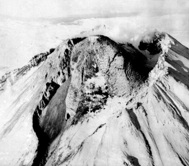 |
Figure 1. Oblique airphoto of Bezymianny's summit in August 1984, showing the new lava carapace covering the E and NE flanks of the dome. |
"The October 1984 eruption was large. The first local earthquakes were recorded on 24 September, simultaneously with the failure of the dome blocks and with the formation of glowing avalanches. At that same time continuous volcanic tremor began, with amplitudes that reached 5 µm during the periods of the most intense explosive activity.
"A dark gray gas-ash plume appeared above the volcano on 13 October. At a height of ~2 km it was traced 40 km ESE. Beginning from 1100 to 1,500, vertical and inclined explosions occurred every 5-10 minutes. Simultaneously, pyroclastic flows were generated, forming a large deposit near the foot of the volcano. Ash clouds rising above moving pyroclastic flows joined with material ejected from the vent to form an eruptive cloud 6-9 km high. The plume was traced 50-100 km ENE. The explosive eruption continued until 15 October. Seismicity ceased the next day, but the extrusion of rigid blocks at the dome summit continued until the end of October. Wreathing gases of white or occasionally gray color were observed continually over the dome. Glowing avalanches periodically rolled down the flanks.
"The paroxysmal eruption was characterized by a powerful explosive phase. A crater formed at the top of the dome and an erosion trench formed on the E flank, essentially dividing the dome into N and S parts. Two pyroclastic flow tongues formed at the foot of the volcano. The S part of the flow, 6 km long, had an area of 2.7 km2 and a volume of 0.013 km3. Tephra . . . covered an area of ~5,000 km2.
Eruptions in 1985. "The next strong eruption occurred in late June-July 1985 and was preceded by small seismic activity. Geologists saw a paroxysmal stage of this eruption from a distance of 8.5 km (P.P. Firstov, A.I. Malyshev, and M.A. Alidibirov). Bad weather limited visual observations, but seismic and acoustic signals (processed by P.P. Firstov from the Apakhonchich seismic station, 16 km from the volcano), in comparison with visual observations, have allowed some interpretation of eruptive dynamics.
"The active phase began, apparently, on 29 June at 1930 when observers heard a strong roar from the volcano lasting half an hour. Three small pyroclastic flows formed between 1922 and 1941. Deposits of these flows as long as 7-8 km were found the next morning. Then the explosive activity of the volcano sharply increased, and seemed to cause a failure of the E part of the dome. The material from the destroyed part of the dome and juvenile pyroclastic material formed a thick block-ash pyroclastic flow that apparently formed in the period from 0705 to 0715 on 30 June and was deposited at a distance of 10 km. Strong explosive activity continued, accompanied by lightning in the cloud. From 1229 to 1425, 10 small pyroclastic flows formed. At 1425-1430 the longest pyroclastic flow (10-12 km) formed, overlapping deposits of former flows. After that, explosive activity began to decrease. The last small pyroclastic flow formed on 1 July at 1930. Then calm lava flow extrusion began from the new dome crater and continued for several months (figure 2).
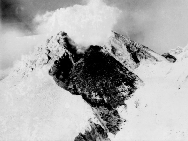 |
Figure 2. Lava flow extruded from the new dome crater at Bezymianny after the June-July 1985 explosions. Lava advances through the crater breach seen (from a higher vantage point) below the dome in figure 1. Photo taken by N. Smelov. |
"Thus, the main events of this eruption are as follows: 1) Moderate explosive activity resulted in destruction and failure of the E part of the complex intracrater dome. A large (0.04 km3) crater formed with an active vent in its upper part. 2) Dome material plus fresh juvenile material formed a thick block and ash pyroclastic flow deposit (with a volume of ~0.01 km3), covering the E foot of the volcano to 8-10 km from the crater. 3) Failure of part of the dome resulted in rapid decompression of the remainder of the dome. Rapid expansion of volcanic gases produced a blast directed to the E that covered an area of 10 km2 and destroyed two volcanologist houses 3.5 km from the crater. Erosion traces on the ruins of the buildings suggest that the ground surge velocity was very high. The temperature, as evidenced by the melting of polyethylene objects, was greater than l50°C. Blast deposits - a layer of stratified sand - had a volume of ~0.001 km3. 4) Continuing explosive activity formed of a series of hot juvenile pyroclastic flows that covered a 3.5 km2 area with a layer 1-5 m thick. The total volume of juvenile pyroclastic material apparently did not exceed 0.01 km3. 5) When the explosive phase of the eruption stopped, calm outpouring of a lava flow began from the newly formed crater.
"Detailed field investigations of the eruption products allowed us to distinguish the following types of pyroclastic deposits: 1) 'Block and ash flow' deposits are the most typical of the eruptions of Bezymianny. They are connected with growth of the intracrater dome, especially during the first two decades, when explosions and extrusion of rigid blocks of the dome occured. During the first stages of the 1984-85 eruption, pyroclastic flows of this type were produced as well. 2) Vesicular (or semi-vesicular) andesite pyroclastic flow deposits are represented by debris of gray vesicular andesites generally of one size (not more than 1-2 m) and by a great amount of fine matrix. The temperature of material at the moment of deposition was ~700°C, and the mean thickness was 2-3 m. The pyroclastic flow deposits represent a complex of separate units. The main pyroclastic flows are distinguished most clearly, each underlain by ground surge deposits associated with the flow, represented by a layer of well-sorted sand 10-12 cm thick. 3) Deposits from ash clouds that rose from pyroclastic flows are represented by stratified and sorted sand at different sites on and around the pyroclastic flow deposits. Gradual transitions from coarse-grained pyroclastic flow deposits to more fine-grained ash cloud deposits were noted. Everywhere these deposits were overlapped by a thin (1-2 cm) layer of pelitic airfall material. Ash cloud deposits were hot; drying and slightly charring the shrubs and grasses on surrounding hills.
"Small amounts of airfall tephra are a characteristic feature of the 1985 eruption. A thin layer of pelitic material which covered the area around the volcano had apparently fallen from the ash cloud that rose from the pyroclastic flows during their movement. The apparent lack of associated airfall beds with some sequences of pyroclastic flows and surges suggests that these might have been formed directly from the crater without the production of an eruption column, with the eruptive material just topping the crater rim (or 'boiling-over') and moving down the outer slopes.
"The chemical composition of dome rocks changed slightly during growth from 59.9% SiO2 in 1956 to 56% SiO2 in 1984-85. Variations in mineral composition were more considerable, from hornblende pyroxene andesites in 1956 to two-pyroxene, well-crystallized, basic andesites in the next ten years. An interesting peculiarity of eruptions during the last 2-3 years is the appearance of tephra more acid (61-62% SiO2) than rocks from either the dome or from pyroclastic flows. Andesites of the dated Novy dome eruptions fall between the curves of tholeiitic and calc-alkaline types, tending to occur close to the latter. In contrast to the rocks from the edifice of the volcano they have a close, slightly differentiated composition. Rocks of the 1984 eruption show a tendency to increase slightly in alkalinity; rocks of the 1985 eruption have a higher Mg content."
Reference. Seleznev, B.V., Dvigalo, V.N., and Gusev, N.A., 1983, Development of Bezymianny volcano according to data on stereophotogrammetric treatment of the aerial survey materials of 1950, 1967, and 1976-1981: Volcanology and Seismology, no. 1, p. 52-64.
Information Contacts: G. Bogoyavlenskaya, I. Kirsanov, P. Firstov, and O. Girina, IV.
Lava extrusion; pyroclastic flows
Based on observations from A.I. Malyshev, a new eruption . . . began in June with the extrusion of a block ~80 m high. From 22 to 29 June, a viscous lava flow ~500-550 m long poured out onto the E flank of the dome. During the night of 24-25 June two small pyroclastic flows were produced, with a volume of ~7.5 x 10⁵ m3 of material covering an area of ~0.25 km2.
Further Reference. Maksimov, A.P., Firstov, P.P., Girina, O.A., and Malyshev, A.I., 1992, The Bezymianny volcano eruption in June 1986: Volcanology and Seismology, no. 1, p. 3-20 (in Russian); 1992, v. 13, p. 1-20 (in English).
Information Contacts: P. Firstov, A. Maksimov, and O. Girina, IV.
Lava extrusions; explosions feed pyroclastic flows
Renewed extrusion of rigid blocks onto the summit lava dome was first observed on 9 December. Lava outflow started during the night of 16-17 December, accompanied by explosions that fed pyroclastic flows ~4 km long. The eruption cloud reached 5-6 km height and extended 40-50 km to the SE. The eruption ended 17 December.
Information Contacts: G. Bogoyavlenskaya, IV.
Rockslide & fumarole activity; plume on NOAA 9 image
Rockslides and fumarolic activity were observed 11-12 October and gas plumes with some ash reached 1 km height. A NOAA 9 satellite image returned at 0518 on 13 October showed a very thin, weak plume drifting 60-80 km NE.
Information Contacts: S. Fedotov and I. Menyailov, IV; W. Gould, NOAA/NESDIS.
No changes observed on 13 April
Weather clouds obscured Bezymianny from ground observers 9-10 April, but no changes were observed at its new extrusive dome during a flight 13 April.
Information Contacts: S. Fedotov and N. Zharinov, IV.
Viscous lava extrusion
"Andesitic dome growth has continued . . . . Since 1977, viscous lava flows have issued from the upper part of the dome. Explosive eruptions have accompanied the dome growth once or twice a year, generating block and ash flows. The strongest post-1956 explosive activity took place in 1985. The E part of the dome collapsed, producing a series of pyroclastic flows that extended as far as 13.5 km. The collapse was accompanied by a small lateral blast. After the explosive activity, extrusion of viscous lava resumed, from a new vent on the dome.
"In 1986, two eruptive episodes generated pyroclastic flows and extrusive activity. The pyroclastic flows advanced as much as 4 km, and the viscous lava flows extruded in 1986 filled a trough formed in the dome during the 1985 activity. Throughout 1987, quiet effusion of viscous lava continued from the upper part of the dome (figure 3). The flows overtopped one another, moved over the filled trough, and advanced to the upper reaches of the eastern avalanche valley."
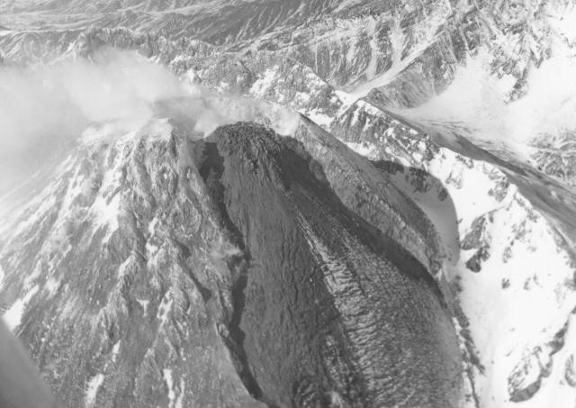 |
Figure 3. Oblique aerial view of Bezymianny from the E on 10 March 1987, showing the dome, and lava moving down the upper E flank. Photo by A.B. Belousov. |
Information Contacts: G. Bogoyavlenskaya and A.B. Belousov, IV.
Gas emission from center of dome
Gas emission from the center of Novy Dome produced a white-and-brown plume that covered the dome complex, especially its NE side, during an 18 May visit. No evidence of recent collapse was visible.
Information Contacts: H. Gaudru, SVE, Switzerland; G. de St. Cyr, T. de St. Cyr, and I. de St. Cyr, A.V. Lyon, France; T. Vaudelin, Genève, Switzerland.
Explosive eruption sends ash plume to 15 km altitude
A strong explosive eruption that began on the afternoon of 21 October with little advance seismic warning was continuing as of 24 October. Ashfall generally obscured the volcano, but ash plumes were observed rising to 8-12 km altitude on 23-24 October and reached 15 km altitude on the afternoon of 24 October. The eruption plume extended >100 km to the ESE. The resulting ash layer was >10 mm thick at a seismic station 15 km NE, and 5 mm thick at a weather station 30 km SE. The U.S. National Weather Service observed a possible volcanic plume along the Kamchatkan coast on the morning of 22 October, but satellite imagery on 24 October showed heavy banded frontal clouds over the Kamchatka Peninsula with no definitive ash cloud visible.
Information Contacts: V. Kirianov, IVGG; T. Miller, AVO; J. Lynch, SAB.
Additional explosions produce ashfall; extrusive dome growth
A strong explosive eruption began at about 1600 on 21 October . . . . This eruption appears to be the largest from Bezymianny since 1956. Ash . . . began falling on the N part of Bering Island (Kommandorski Islands), ~515 km ESE . . ., between 2300 on 21 October and 0500 the next day. The deposit consisted of a very thin layer of fine dark ash. No ashfall was reported at Shemya Air Force Base (Shemya Island), 1,275 km E . . . in the western Aleutians. Though . . . obscured on 22 October, a gas-and-steam column was visible above the cloud cover to an unknown altitude. That morning, the NWS observed a possible volcanic plume on satellite imagery extending for several tens of kilometers along the Kamchatkan coast.
Heavy ashfall frequently obscured the volcano through 24 October, but ash plumes were observed rising to 8-12 km altitude on 23-24 October. The eruption plume reached 15 km altitude on the afternoon of 24 October, and extended >100 km to the ESE. The resulting ash layer was >10 mm thick at a seismic station 15 km NE, and 5 mm thick at a weather station 30 km SE. Satellite imagery on 24 October showed heavy banded frontal clouds moving NNE over the Kamchatka Peninsula with no definitive ash cloud visible. The Level of Concern Color Code was raised to Red on 24 October by the KVERT, indicating that large ash eruptions were expected.
Strong seismicity on 25-26 October, including 8 hours of tremor, indicated continuing eruptive activity, although clouds prevented observations 24-28 October. Satellite imagery on 25-26 October continued to show layered frontal clouds over the Kamchatka Peninsula with no definitive ash cloud. The duration of volcanic tremor decreased from 8 hours/day on 25 October to 45 minutes/day on 28 October. This decline in seismicity prompted KVERT to lower the Level of Concern Color Code to Yellow (volcano is restless), however, the level was soon raised back to Orange (small ash eruptions expected/confirmed) following renewed activity.
A violent explosive outburst at 0245-0330 on 28 October resulted in ashfall in the town of Kliuchi, 45 km NNE. Another explosion at 0300 on 29 October sent an ash plume to the NNE and deposited 2 mm of ash in Kliuchi 1-2 hours later. Seismicity again indicated continued activity from 30 October to 2 November while the volcano was obscured by clouds. Volcanic tremor was recorded for 30 minutes on 30 October and for 4 hours on 31 October, with events located beneath the volcano. Earthquakes and volcanic tremor were detected again on 1-2 November. As of 6 November, about one hour/day of volcanic tremor was being registered, indicative of continued extrusive dome growth; an ash plume was no longer visible above the summit. The decrease in activity resulted in a lowering of the Level of Concern Color Code from Orange to Yellow.
TOMS data from the Meteor-3 satellite in the second half of October did not reveal an SO2 cloud . . . . High latitude coverage in the winter is extremely limited due to reduced daylight hours, resulting in spotty coverage around Bezymianny. However, it is possible that SO2 concentrations were below the TOMS detection levels, or that the cloud was missed by TOMS coverage.
A KVERT geologist who visited the volcano on 12 November reported that activity had declined but was continuing. A steam-and-gas plume with a small amount of ash rose about 3 km above the crater rim; the plume was directed to the ESE for >50 km and light ashfall was occurring along the axis. The extrusive dome was still growing, but the SE side had been partially destroyed. Viscous lava was being emitted from the dome vent. Pyroclastic flows formed in the first days of the eruption had traveled ~14-16 km. Near the base of the dome, the pyroclastic-flow deposits were estimated to be ~15 m thick. At 1300 on 12 November an earthquake under the volcano caused rockslides on the dome slopes.
Information Contacts: V. Kirianov, IVGG; T. Miller, AVO; J. Lynch, SAB; G. Bluth, GSFC.
Still restless after strong October eruption, but tremor declines
. . . more subdued eruptive activity followed during November through mid-December. On 15 November, the town of Kliuchi, ~50 km NNE of Bezymianny, received weak ashfall. On 18 November, a steam-and-gas plume containing a small amount of ash rose 3-4 km above Bezymianny's crater rim. The plume extended toward the N and E for more than 60 km. During the last week of November, weak tremor shook for 3-8 hours/day, dropping to 2-3 hours/day during the first week of December. By mid-December, the tremor level fell to about background levels.
The KVERT characterizes Kamchatkan volcanoes with a Level of Concern Color Code. The Code was last reported on 4 December as Yellow, indicating the volcano is restless.
Information Contacts: V. Kirianov, IVGG.
Gas-and-steam plume persists with some ash
Seismicity was at background levels from mid-December 1993 through mid-February 1994. On 3 January a large steam-and-gas plume was seen to extend 40 km NE. The next day a large ash-and-gas plume stretched 60 km NE from the crater. One shallow earthquake was recorded on 18 January centered beneath the volcano. Volcanic tremor lasting 30 minutes on 21 January may have been caused by a small explosion from the extrusive summit lava dome. A gas-and-steam plume with a small amount of ash was again observed in early February extending 60 km SE.
Information Contacts: V. Kirianov, IVGG.
Gas-and-steam plume seen for the first time since February 1994
Seismicity remained at background levels from mid-July through early September. However, during 7-14 July, a gas-and-steam plume with a small amount of ash was observed rising ~500 m above the extrusive dome. On 11 July the ash-and-steam plume rose to ~3,000 m asl and drifted generally NE. The gas-and-steam plume extended 150 m above dome through 24 July. During the week of 11-18 August a gas-and-steam plume rose ~200 m above the volcano. A small gas-and-steam plume (to 50-70 m above the volcano) continued during the last 2 weeks of August. On 2-8 September, E. Zhdanova (KVERT) observed a viscous lava flow being "squeezed" from the extrusive dome. A gas-and-ash plume reached 1 km above the volcano and extended >40 km from the volcano. The volcano was obscured by clouds during the next week.
Information Contacts: V. Kirianov, IVGG.
Seismicity at normal levels; steam plume as high as 1,000 m
Cloudy weather prevented observations on most days during the second half of September and October, but seismicity remained at normal levels. A gas-and-steam plume rose to 100 m above the volcano on 16 September, and to 1,000 m the week of 18-24 September. Activity was at normal levels the next two weeks. When conditions permitted, observers in Kozirevsk (~45 km WNW) saw a white steam cloud reaching 500-700 m above the crater on 13 October, 200 m on the 20th and 22nd, and 50 m on the 27th.
Information Contacts: V. Kirianov, IVGG; AVO.
Small white steam plume; normal seismicity
During breaks in the cloudy weather during late October and November, observers in Kozirevsk (~50 km WNW) reported a white steam cloud reaching 50 m above crater on 27 October and 150 m on 18 November that was directed SE. On 24-28 November, observers in Kozirevsk noted weak fumarolic activity above the summit dome. Seismicity remained normal throughout November and early December. No information was available for the second half of December because of the suspension of communications from KVERT.
Information Contacts: V. Kirianov, IVGG; AVO.
Explosive eruption causes 2-3 mm of ashfall 50 km away
At 0500 on 6 October, regional seismic stations began to record volcanic tremor with a maximum amplitude of 5-6 µm. An ash plume was detected by the Alaska Volcano Observatory (AVO) on a satellite image taken at 0824. The Institute of Volcanology (IV) reported that an eruptive column first appeared over Bezymianny around that time, and by 0900 it was ~8 km high. Weather satellite imagery at 0948 showed that the plume had reached the coastline nearly due E, with a top estimated to be 10 km above sea level.
At 0930, volcanic ash started to fall in Kliuchi, ~50 km NNE. Tremor and ash emission increased up to 1200, followed by 3 hours of intense ashfall; during a period of 140 minutes 700 g/m2 of ash fell in Kliuchi. Because the air in Kliuchi was strongly polluted with volcanic gas, a warning was issued for the residents to take precautions. From Kliuchi, E. Zhdanova, a volcanologist from the Institute of Volcanic Geology and Geochemistry (IVGG), reported that ashfall had stopped at about 1700 on 6 October after 2-3 mm of deposition. AVO satellite imagery at 1813 showed the disconnected ash plume ~150 km E. The plume was moving ENE and was over 400 km from the source. By about 0930 on 7 October, the ash plume had undergone significant diffusion and was no longer detectable on satellite images.
As of the morning of 7 October the volcano was obscured, but there was no more tremor. Zhdanova suggested that the explosive phase of the eruption had ended and a lava dome was forming again. This interpretation was confirmed by a large hot spot seen at the vent on AVHRR imagery after the ash cloud had disconnected from the volcano.
Information Contacts: Alaska Volcano Observatory; E. Zhdanova and V. Kirianov, Institute of Volcanic Geology & Geochemistry, Piip Avenue 9, Petropavlovsk-Kamchatsky, 683006, Russia; N.A. Zharinov and S.A. Fedotov, Institute of Volcanology, Petropavlovsk-Kamchatsky, 683006, Russia.
Degassing continues
Seismicity remained at or a little above normal background levels from 26 May to 22 July. Gas-and-steam plumes rose 100-300 m above the crater and extended ~2-7 km downwind. On 30 June, seismicity increased slightly, possibly associated with processes inside the extrusive lava dome. Regular reports from KVERT (via AVO) resumed in June after funding problems in Russia halted communications in December 1994 (BGVN 19:11).
Information Contacts: Tom Miller, Alaska Volcano Observatory (AVO), a cooperative program of a) U.S. Geological Survey, 4200 University Drive, Anchorage, AK 99508-4667, USA, b) Geophysical Institute, University of Alaska, PO Box 757320, Fairbanks, AK 99775-7320, USA, and c) Alaska Division of Geological & Geophysical Surveys, 794 University Ave., Suite 200, Fairbanks, AK 99709, USA; Vladimir Kirianov, Kamchatka Volcanic Eruptions Response Team (KVERT), Institute of Volcanic Geology and Geochemistry, Piip Ave. 9, Petropavlovsk-Kamchatsky, 683006, Russia.
Lava extrusion, rock avalanches, and increasing seismicity
Scientists doing fieldwork on 23-24 July observed up to six cold rock avalanches that were connected with extrusive block (obelisk) growth on the dome of the volcano. A number of local earthquakes were also recorded at the nearest seismic station (14 km away).
On 20-22 August a weak fumarolic cloud was observed. Seismicity at the volcano during 19-26 August was above background levels, and both the number and energy of earthquakes gradually increased. A viscous lava flow extruded from the top of the dome during 26-28 August and 31 August-1 September, but no ash explosions were observed.
Information Contacts: Tom Miller, Alaska Volcano Observatory (AVO), 4200 University Drive, Anchorage, AK 99508-4667, USA; Vladimir Kirianov, Kamchatka Volcanic Eruptions Response Team (KVERT), Institute of Volcanic Geology and Geochemistry, Piip Ave. 9, Petropavlovsk-Kamchatsky, 683006, Russia.
Fumarolic plumes reach to 500 m
On 8, 10, and 23 September, and 9, 13, 16, 18, 20, and 21 November, fumarolic plumes were observed reaching as high as 500 m above the volcano. The plumes extended as far as 40 km to the NE or E.
Information Contacts: Tom Miller, Alaska Volcano Observatory (AVO), 4200 University Drive, Anchorage, AK 99508-4667, USA; Vladimir Kirianov, Kamchatka Volcanic Eruptions Response Team (KVERT), Institute of Volcanic Geology and Geochemistry, Piip Ave. 9, Petropavlovsk-Kamchatsky, 683006, Russia.
Fumarolic plumes seen
On 5-6 and 17 December and on 4, 9, and 14-15 January, fumarolic plumes were observed reaching as high as 100 m above the crater. The plumes extended 10 km downwind.
Information Contacts: Tom Miller, Alaska Volcano Observatory (AVO), a cooperative program of a) U.S. Geological Survey, 4200 University Drive, Anchorage, AK 99508-4667, USA (URL: http://www.avo.alaska.edu/), b) Geophysical Institute, University of Alaska, PO Box 757320, Fairbanks, AK 99775-7320, USA, and c) Alaska Division of Geological & Geophysical Surveys, 794 University Ave., Suite 200, Fairbanks, AK 99709, USA; Vladimir Kirianov, Kamchatka Volcanic Eruptions Response Team (KVERT), Institute of Volcanic Geology and Geochemistry, Piip Ave. 9, Petropavlovsk-Kamchatsky, 683006, Russia.
Eruption sends plume to 4 km above crater on 9 May
Although more vigorous eruptions took place in May, scientists at the Institute of Volcanology (IV) reported that activity in early April was limited to moderate gas-and-steam emissions. Between 19 and 23 April, seismic stations at Zelenaya and Podkova, 14 and 23 km from the volcano, respectively, detected very low (up to 0.1 µm) tremor.
IV scientists also reported that at 0545 on 9 May an eruption plume rose to ~4 km above the crater and extended 40 km SE early in the eruption. Within two hours activity declined slightly, but pyroclastic outbursts reached 3,000 m above the crater. At 1312, Kozyrevsk and Klyuchi stations detected a strong explosion that sent an eruption column >10 km above the crater. The plume changed directions, drifted NNE, and at 1630 ashfall began in the town of Klyuchi, 47 km from the volcano. The two-hour ashfall deposited 180 g/m2 of measured ash in Klyuchi.
A scientist from the Institute of Volcanic Geology and Geochemistry (IVGG) reported that the column from this event extended ENE for several tens of kilometers. He also reported that at 1600 two vents may have been active. Satellite images acquired at 1930 on 9 May indicated the plume extended ~400 km ENE.
At about 0300 on 10 May, visual observations made by IVGG volcanologists revealed that the plume rose to ~6,100 m and extended at least several tens of kilometers SE. They also reported that seismic activity had declined from the high levels recorded during the most explosive events of 9 May. At 0600 on 10 May, GMS-5 satellite imagery showed the plume extended ~700 km ENE.
Information Contacts: N.A. Zharinov and Yu.V. Demyanchuk, Institute of Volcanology, Petropavlovsk-Kamchatsky, 683006, Russia; Tom Miller, Alaska Volcano Observatory (AVO), a cooperative program of a) U.S. Geological Survey, 4200 University Drive, Anchorage, AK 99508-4667, USA (URL: http://www.avo.alaska.edu/), b) Geophysical Institute, University of Alaska, PO Box 757320, Fairbanks, AK 99775-7320, USA, and c) Alaska Division of Geological & Geophysical Surveys, 794 University Ave., Suite 200, Fairbanks, AK 99709, USA; Vladimir Kirianov, Kamchatka Volcanic Eruptions Response Team (KVERT), Institute of Volcanic Geology and Geochemistry, Piip Ave. 9, Petropavlovsk-Kamchatsky, 683006, Russia; Bureau of Meteorology, Northern Territory Regional Office, P.O. Box 735, Darwin, NT 0801 Australia.
Tracking 9 May plumes; ash eruption on 15 May
The previous report on Bezymianny (BGVN 22:04) described an early May eruption. That event spawned aviation reports, including ash-cloud dispersion observations and forecasts that showed the 9 May plume moving hundreds of kilometers ENE- NE.
In one case (at 0832 GMT), satellite imagery disclosed two clouds at different altitudes. One cloud was still attached to the volcano; it reached ~500 km E-W; it spread both E and W from the volcano but was offset slightly to the N. The other cloud was detached and higher; it lay over the Bering Sea centered ~600 km NE of the summit.
About an hour later (at 0932 GMT), the lower cloud detached and moved N. The higher cloud covered a larger area and moved NE to assume a position with its N margin overlying the mainland. The lower cloud shifted N and detached from the source.
An aviation report on 15 May mentioned ash erupted from the volcano before 2015 GMT. This was confirmed by AVO and satellite imagery. Ash, however, was not detected the next day on satellite images.
Several gas-and-steam plumes were noted in July. On the 14th one rose to 1 km above the crater and moved 25 km E. During 15-20 July, others rose 100-400 m above the crater and blew 5-10 km to the E and SE. On 21 July one rose 50 m above the crater; yet another on 27 July rose 300 m above the crater and moved 20 km to the W.
Information Contacts: Vladimir Kirianov, Kamchatka Volcanic Eruptions Response Team (KVERT), Institute of Volcanic Geology and Geochemistry, Piip Ave. 9, Petropavlovsk-Kamchatsky, 683006, Russia; Tom Miller, Alaska Volcano Observatory (AVO), a cooperative program of a) U.S. Geological Survey, 4200 University Drive, Anchorage, AK 99508-4667, USA (URL: http://www.avo.alaska.edu/), b) Geophysical Institute, University of Alaska, PO Box 757320, Fairbanks, AK 99775-7320, USA, and c) Alaska Division of Geological & Geophysical Surveys, 794 University Ave., Suite 200, Fairbanks, AK 99709, USA; Bureau of Meteorology, Northern Territory Regional Office, P.O. Box 735, Darwin NT 0801, Australia; NOAA/NESDIS Satellite Analysis Branch (SAB), Room 401, 5200 Auth Road, Camp Springs, MD 20746, USA.
Small gas-and-steam plumes
Only small gas-and-steam plumes extending hundreds of kilometers downwind have been seen since ash eruptions in May sent plumes up to 10 km above the crater (BGVN 22:04 and 22:06). Weak fumarolic activity (50-100 m above the crater) was observed on 5-6 August, 7, 15-16, 24, 25, 27, and 29 September, and 8-9 October. Cloud cover obscured the volcano from view on most days.
Information Contacts: Vladimir Kirianov, Kamchatka Volcanic Eruptions Response Team (KVERT), Institute of Volcanic Geology and Geochemistry, Piip Ave. 9, Petropavlovsk-Kamchatsky, 683006, Russia; Tom Miller, Alaska Volcano Observatory (AVO), a cooperative program of a) U.S. Geological Survey, 4200 University Drive, Anchorage, AK 99508-4667, USA (URL: http://www.avo.alaska.edu/), b) Geophysical Institute, University of Alaska, PO Box 757320, Fairbanks, AK 99775-7320, USA, and c) Alaska Division of Geological & Geophysical Surveys, 794 University Ave., Suite 200, Fairbanks, AK 99709, USA.
Explosive eruption on 5 December
An explosive eruption began on 5 December. Seismic and fumarolic activity had mainly been normal since May 1997 (BGVN 22:09). Seismicity was at background level during 13 October-2 November with normal fumarolic activity (plumes 50-100 m tall) observed during 21-26 October. During 3-9 November seismicity increased and plumes up to 1 km high were seen; the plume extended 10-15 km SSE on 8-9 November. Normal low plumes were again seen on 12, 14-15, 18, 27, and 30 November.
A growing hot spot was monitored on satellite images by Alaska Volcano Observatory (AVO) remote sensing specialists during 3-4 December. The hot spot was not accompanied by unusual activity; it was assumed to be related to small debris avalanches at the dome. Visual observations during that period indicated that a fumarolic plume rose 500 m above the volcano and extended 15-20 km SW.
An explosive eruption began at about 0630 on 5 December. No preliminary seismicity was detected; however, the eruption's onset was indicated by an abrupt increase in seismicity. By 0830, the eruption plume reached a height of 6 km and had traveled ~20 km NE. By 1200 observers in the towns of Kozyrevsky and Klyuchi reported an increase in the eruption's intensity; at 1215, the Kamchatka Volcanic Eruption Response Team (KVERT) estimated the plume height at ~9 km dispersing >50 km NE . . . . Seismicity remained elevated until 1400, but eruptive activity declined.
Several volcanic ash advisories were issued to warn aviators about the ash plume during 5-7 December. For example, an advisory at 1015 on 5 December reported an ash plume extending 15 km NE at an altitude of ~6 km. Another advisory cited a GMS infrared image taken at [0932] showing a plume 55 km wide extending NE (figure 4). [Satellite imagery at 1332 showed the plume rising to ~9-10 km; it was 63 km wide and extended 211 km E. Pilot reports later in the day estimated the ash plume at altitudes of ~12-13 km.] . . . .
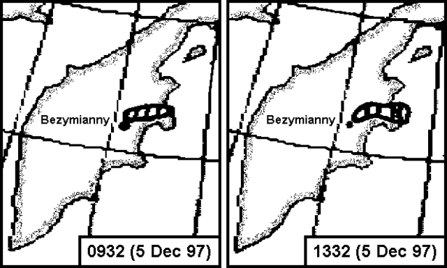 |
Figure 4. [Sketches showing Bezymianny's ash plume on 5 December 1997 at 0932 (2132 GMT on 4 December) and 1332 (0132 GMT) based on GMS infrared satellite imagery. Courtesy of SAB.] |
. . . [Judging from] satellite imagery, activity declined during the night of 5-6 December. At 0800 on 6 December, a small steam plume with little to no ash rose ~3.5-4 km and moved ~20 km NE. By 1030 decreased eruptive activity led KVERT to downgrade the hazard status to yellow (during the eruption it was red). Local seismicity was masked by intense aftershocks following a M 7.8 earthquake off the E coast of Kamchatka during the night of 5-6 December.
On 7 December, a gas-and-steam plume rose 500 m above the volcano and extended as far as 1 km SE. A fumarolic plume on 8-9 December rose 50-100 m and extended SE. By 9 December, the hazard status had returned to green and seismicity was at background. During 15-21 December, the volcano was obscured by clouds but seismicity remained normal. A fumarolic plume on 24 December rose 50-100 m above the volcano.
Information Contacts: Vladimir Kirianov, Kamchatka Volcanic Eruptions Response Team, IVGG, Piip Blvd, 9 Petropavlovsk-Kamchatskiy, 683006, Russia; Tom Miller, Alaska Volcano Observatory (AVO), a cooperative program of a) U.S. Geological Survey, 4200 University Drive, Anchorage, AK 99508-4667, USA (URL: http://www.avo.alaska.edu/), b) Geophysical Institute, University of Alaska, PO Box 757320, Fairbanks, AK 99775-7320, USA, and c) Alaska Division of Geological & Geophysical Surveys, 794 University Ave., Suite 200, Fairbanks, AK 99709, USA; NOAA/NESDIS Satellite Analysis Branch (SAB), Room 401, 5200 Auth Road, Camp Spring, MD 20746, USA.
Small January steam plumes; correction to 5 December ash plume description
According to the Kamchatka Volcanic Eruptions Response Team (KVERT), activity decreased during January compared to December (BGVN 22:12). During all of January the level of concern was green. Except on many days of bad weather, when observation was impossible, small fumarolic plumes were observed. Typically, plumes rose to 50-100 m above the summit as did those observed on 24, 30, and 31 December, and on 11, 13, 15, 19, and 22 January. The plume of 30 December extended 3-5 km to the E and S. Plumes on 19 and 22 January extended 5 km SE. Observers noted a somewhat larger plume on 18 January, which rose to 300 m and extended 20 km from the summit.
Correction: The ash plume from the eruption on 5 December 1997 was much smaller than previously indicated (BGVN 22:11). The figure in that report was described as showing the advance of an ash plume based on satellite imagery; what it really showed was a series of projected plume locations. The projections were issued in Alaska to provide aviators with an estimate of the plume's dispersal if the eruption continued.
The following gives a more accurate account of the plume during 5 December based on the relevant infrared satellite imagery described in volcanic ash advisories. For example, one 5 December advisory cited a GMS infrared image taken at 0932 showing a plume 55 km wide extending NE (figure 5). Another advisory at 1015 on 5 December reported an ash plume extending 15 km NE at an altitude of ~6 km. Satellite imagery at 1332 showed the plume rising to ~9-10 km; it was 63 km wide and extended 211 km E (figure 5). Pilot reports later in the day placed the ash plume at altitudes of ~12-13 km. Other volcanic ash advisories continued to warn aviators about the ash plume during 6-7 December.
 |
Figure 5. Revised sketches showing Bezymianny's ash plume on 5 December 1997 at 0932 (2132 GMT on 4 December) and 1332 (0132 GMT). Plumes were based on GMS infrared satellite imagery. Courtesy of SAB. |
The time conversion to Kamchatkan Standard Time was also misstated; it should be GMT + 12 hours. Our thanks to Nick Heffter (NOAA Air Resources Laboratory) and the NOAA Satellite Analysis Branch for assisting in this correction.
Information Contacts: Vladimir Kirianov, Kamchatka Volcanic Eruptions Response Team (KVERT), Institute of Volcanic Geology and Geochemistry, Piip Ave. 9, Petropavlovsk-Kamchatsky, 683006, Russia; Tom Miller, Alaska Volcano Observatory (AVO), a cooperative program of a) U.S. Geological Survey, 4200 University Drive, Anchorage, AK 99508-4667, USA (URL: http://www.avo.alaska.edu/), b) Geophysical Institute, University of Alaska, PO Box 757320, Fairbanks, AK 99775-7320, USA, and c) Alaska Division of Geological & Geophysical Surveys, 794 University Ave., Suite 200, Fairbanks, AK 99709, USA; NOAA/NESDIS Satellite Analysis Branch (SAB), Room 401, 5200 Auth Road, Camp Springs, MD 20746, USA.
Fumarolic plumes present on most days
Fumarolic plumes rose 50-800 m above the volcano on 27 January, 3-5, 9, 12-14, 17-18, 20-22, 23-25, and 28 February. A steam plume rose 50 m on 30 January. Plumes on 17-18, 23-25, and 28 February traveled SE. No seismicity registered under the volcano during 23 February-1 March.
Information Contacts: Vladimir Kirianov, Kamchatka Volcanic Eruptions Response Team (KVERT), Institute of Volcanic Geology and Geochemistry, Piip Ave. 9, Petropavlovsk-Kamchatsky, 683006, Russia; Tom Miller, Alaska Volcano Observatory (AVO), a cooperative program of a) U.S. Geological Survey, 4200 University Drive, Anchorage, AK 99508-4667, USA (URL: http://www.avo.alaska.edu/), b) Geophysical Institute, University of Alaska, PO Box 757320, Fairbanks, AK 99775-7320, USA, and c) Alaska Division of Geological & Geophysical Surveys, 794 University Ave., Suite 200, Fairbanks, AK 99709, USA.
Fumarolic plumes observed often
No seismicity registered under the volcano during 2 March-5 April. On 5-7, 10, and 12-14 March, fumarolic plumes rose 50-300 m above the volcano. Fumarolic plumes on 16-20 and 22 March rose 50-200 m above the volcano and moved 5-10 km SSE. On 30-31 March and 1-4 April fumarolic plumes rose 100-500 m above the volcano.
Information Contacts: Vladimir Kirianov, Kamchatka Volcanic Eruptions Response Team (KVERT), Institute of Volcanic Geology and Geochemistry, Piip Ave. 9, Petropavlovsk-Kamchatsky, 683006, Russia; Tom Miller, Alaska Volcano Observatory (AVO), a cooperative program of a) U.S. Geological Survey, 4200 University Drive, Anchorage, AK 99508-4667, USA (URL: http://www.avo.alaska.edu/), b) Geophysical Institute, University of Alaska, PO Box 757320, Fairbanks, AK 99775-7320, USA, and c) Alaska Division of Geological & Geophysical Surveys, 794 University Ave., Suite 200, Fairbanks, AK 99709, USA.
Slowly growing hot spot seen on satellite image
During 28-30 May, a fumarolic plume was seen rising to 50-300 m above the volcano and moving 5 km E. Visual observations made on 28 May indicated color changes in the fumarolic plume suggesting an increase in gas emission.
Satellite images of Bezymianny made during 1-10 June, when not obscured by clouds, indicated a persistent and slowly growing hot-spot more than 5 km2 in size. This thermal anomaly persisted until late June. It was similar to that observed shortly before the 5 December 1997 eruption (BGVN 22:11), which sent a short-lived eruption plume to over 9 km above sea level. It likely indicates that the summit lava dome is growing again and may be subject to a sudden partial collapse similar to the 5 December event. KVERT changed the level of concern color code to yellow-alert and will monitor the situation closely.
Seismicity during 1-10 June was at background levels. No seismicity was reported during the next three weeks. Fumarolic plumes were seen rising 100 to 800 m and moving up to 10 km to the SE and S during 9-11, 17, and 19-21 June.
Information Contacts: Olga Chubarova and Vladimir Kirianov, Kamchatka Volcanic Eruptions Response Team (KVERT), Institute of Volcanic Geology and Geochemistry, Piip Ave. 9, Petropavlovsk-Kamchatsky, 683006, Russia; Tom Miller, Alaska Volcano Observatory (AVO), a cooperative program of a) U.S. Geological Survey, 4200 University Drive, Anchorage, AK 99508-4667, USA (URL: http://www.avo.alaska.edu/), b) Geophysical Institute, University of Alaska, PO Box 757320, Fairbanks, AK 99775-7320, USA, and c) Alaska Division of Geological & Geophysical Surveys, 794 University Ave., Suite 200, Fairbanks, AK 99709, USA.
Avalanches and glow at Novy dome on 20-22 June
Avalanches and glow from the Novy dome were observed during 20-22 June. On 22 June a fumarolic plume rose to 300-500 m above the volcano, followed the next day by a smaller gas-and-steam plume 100-300 m high. Weak and shallow seismic events were registered throughout the week of 22-29 June. Plumes 50-100 m in height were seen 29 June-2 July, and 6-7 July; clouds obscured observation for much of the rest of the month of July. Little or no seismicity was recorded during July.
Information Contacts: Olga Chubarova, Kamchatka Volcanic Eruptions Response Team (KVERT), Institute of Volcanic Geology and Geochemistry, Piip Ave. 9, Petropavlovsk-Kamchatsky, 683006, Russia; Tom Miller, Alaska Volcano Observatory (AVO), a cooperative program of a) U.S. Geological Survey, 4200 University Drive, Anchorage, AK 99508-4667, USA (URL: http://www.avo.alaska.edu/), b) Geophysical Institute, University of Alaska, PO Box 757320, Fairbanks, AK 99775-7320, USA, and c) Alaska Division of Geological & Geophysical Surveys, 794 University Ave., Suite 200, Fairbanks, AK 99709, USA.
Series of deep and shallow earthquakes
Eruptive activity continued at a very low level during January. The alert level remained at green. Fumarolic plumes rose a few hundred meters above the summit before being blown up to 10 km away on 13-14, 19-20, 22, and 24-28 January. On 23 January the plume rose 1,000 m above the summit and extended in a fan-shaped cloud 15 km WNW. On most other days during the month the summit was obscured. One earthquake was recorded on 1 January and five were recorded during 26-31 January.
Information Contacts: Olga Chubarova, Kamchatka Volcanic Eruptions Response Team (KVERT), Institute of Volcanic Geology and Geochemistry, Piip Ave. 9, Petropavlovsk-Kamchatsky, 683006, Russia; Tom Miller, Alaska Volcano Observatory (AVO), a cooperative program of a) U.S. Geological Survey, 4200 University Drive, Anchorage, AK 99508-4667, USA (URL: http://www.avo.alaska.edu/), b) Geophysical Institute, University of Alaska, PO Box 757320, Fairbanks, AK 99775-7320, USA, and c) Alaska Division of Geological & Geophysical Surveys, 794 University Ave., Suite 200, Fairbanks, AK 99709, USA.
Explosions on 25 February send gas-and-ash plume 5 km above the summit
During February, seismic and volcanic activity at Bezymianny increased in intensity, causing the hazard status to be raised from Green to Yellow on 16 February and then to Orange on 25 February. The activity decreased on the 26th and the "Level of Concern Color Code" was reduced to Yellow. In the first two weeks of the month, numerous weak earthquakes were registered under the volcano, and fumarolic plumes rising up to a few hundred meters above the summit occurred frequently.
Starting on 15 February and continuing the following week, seismicity rose above background levels and 20-40 shallow earthquakes were registered every day. The hazard status was raised to Yellow. Fumarolic plumes continued to rise to a few hundred meters above the summit, and could be seen when not obscured by clouds. Satellite images during the week indicated a persistent thermal anomaly possibly caused by rock avalanches from the summit dome.
The hazard status was raised to Orange on 25 February after volcanic tremor began under the volcano and continued for ~6 hours. Two large explosions during that period each lasted several minutes and a gas-and-ash plume rose 5 km above the summit. Satellite images that morning showed an ash-rich plume heading SE. Over the next few days, using satellite imagery, the ash cloud was tracked for 1,500 km to the SE, but by early on the 27th the cloud had dissipated. Activity declined after the 25th and the hazard status was reduced to Yellow.
On 27-28 February the seismicity was above background levels. Low-level spasmodic tremor continued to be recorded. On the morning of 28 February a steam-and-gas plume rose 300 m. The volcano was obscured by clouds after 28 February.
Information Contacts: Olga Chubarova, Kamchatka Volcanic Eruptions Response Team (KVERT), Institute of Volcanic Geology and Geochemistry, Piip Ave. 9, Petropavlovsk-Kamchatsky, 683006, Russia; Tom Miller, Alaska Volcano Observatory (AVO), a cooperative program of a) U.S. Geological Survey, 4200 University Drive, Anchorage, AK 99508-4667, USA (URL: http://www.avo.alaska.edu/), b) Geophysical Institute, University of Alaska, PO Box 757320, Fairbanks, AK 99775-7320, USA, and c) Alaska Division of Geological & Geophysical Surveys, 794 University Ave., Suite 200, Fairbanks, AK 99709, USA.
Aseismic with largely minor steaming through 9 August
From the period of 31 May 1999 thru 9 August 1999, no seismic activity was registered under the volcano. Fumarolic activity occurred periodically, with occasional plumes of gas-and-steam rising to a few hundred meters above the crater and extending several kilometers from the volcano.
On 18 June, a gas-and-steam plume rose 100 m above the crater, extending S more than 3 km, while a gas-and-steam plume on 28 June rose 400 m above the crater and extended fan-like 30 km to the E. Similar plumes occurred on 11, 13, 21, and 26 July, some rising as high as 300 m above the crater and extending up 10 km from the volcano.
Information Contacts: Olga Chubarova, Kamchatka Volcanic Eruptions Response Team (KVERT), Institute of Volcanic Geology and Geochemistry, Piip Ave. 9, Petropavlovsk-Kamchatsky, 683006, Russia; Tom Miller, Alaska Volcano Observatory (AVO), a cooperative program of a) U.S. Geological Survey, 4200 University Drive, Anchorage, AK 99508-4667, USA (URL: http://www.avo.alaska.edu/), b) Geophysical Institute, University of Alaska, PO Box 757320, Fairbanks, AK 99775-7320, USA, and c) Alaska Division of Geological & Geophysical Surveys, 794 University Ave., Suite 200, Fairbanks, AK 99709, USA.
Frequent fumarolic plumes, but no seismicity
Fumarolic plumes generally rising 50-300 m above the volcano were often observed during clear weather in August-December 1999, but views were frequently obscured by meteorological clouds. Weak fumarolic activity without a significant plume was detected on a few other occasions during this period. Plumes were observed on the following days: 9-10, 16, and 20-23 August; 2, 12, 22, 26, and 28 September; 22-24, 25-27, and 29-31 October; 1, 5, 11-12, 19, 22-23, 26, and 29 November; 2-3, 24, 25, and 28 December. Depending on local conditions, the plumes often extended 5-10 km downwind, usually E and SE. Others were blown S, NW, or NE. The longest plume during this period was on 26 August when it extended 15 km NE. No seismicity was registered under the volcano from 10 August through the end of December 1999. On October 6, a shallow earthquake was registered under the volcano.
Information Contacts: Olga Chubarova, Kamchatka Volcanic Eruptions Response Team (KVERT), Institute of Volcanic Geology and Geochemistry, Piip Ave. 9, Petropavlovsk-Kamchatsky, 683006, Russia; Tom Miller, Alaska Volcano Observatory (AVO), a cooperative program of a) U.S. Geological Survey, 4200 University Drive, Anchorage, AK 99508-4667, USA (URL: http://www.avo.alaska.edu/), b) Geophysical Institute, University of Alaska, PO Box 757320, Fairbanks, AK 99775-7320, USA, and c) Alaska Division of Geological & Geophysical Surveys, 794 University Ave., Suite 200, Fairbanks, AK 99709, USA.
Volcanic tremor in mid-February and mid-March, ash clouds in mid-March
This report covers the period January-April 2000. As of 28 April 2000, KVERT (Kamchatkan Volcanic Eruption Response Team) temporarily suspended operations because of a lack of funding. Except for brief episodes of volcanic and seismic activity in mid-February and mid-March, little to no seismicity was registered beneath the volcano through the remainder of the period. Occasional, weak fumarolic activity was frequently accompanied by fumarolic plumes rising 50-800 m above the volcano and extending up to 50 km away. The volcano frequently was obscured by clouds, which prevented both visual and satellite observations.
During the week of 11-17 February seven shallow earthquakes were registered beneath the volcano. Seismic activity increased above background levels during 10-13 March, and on 14 March the hazard level color code was raised to Red due to continuous volcanic tremor after 0425, which occasionally registered at distances 100 km. At 0430, a satellite image showed a 4-pixel thermal anomaly with a temperature of 50°C and a small ash cloud. At 0742, the ash cloud rose to 5 km altitude and spread to the W; at 0815 ashfall was recorded in Kozirevsk; and at 1100 the ash cloud covered Kozirevsk and spread up to the Sredinny Range, a distance of 225 km. After 1000, the level of volcanic activity decreased and on 15 March the hazard status was reduced to Yellow after seismicity decreased to background levels. Analysis by the Alaska Volcano Observatory (AVO) of a satellite image taken at 0630 on 15 March revealed a 6-pixel thermal anomaly but no ash cloud. According to GMS-5 satellite data (Tokyo VAAC), between 0932 and 2032 on 15 March the ash cloud drifted across Shelekhov Bay and moved NW at an altitude of ~7 km.
At 0500 on the morning of 16 March the volcano erupted again, prompting a hazard status change to Orange. AVO reported that a satellite image taken at 0530 showed an 8-pixel thermal anomaly and a detached ash cloud drifting SW with the leading edge ~140 km from the volcano. The size of the cloud was estimated to be ~100 km E-W by 60 km N-S, but no height estimate was available. KVERT detected increased seismic activity under the volcano with volcanic tremor beginning around 2350 on 15 March and continuing until 0930 the next morning.
Visual reports at 2106 on 18 March from the village of Kozirevsk indicated that a dark dense plume rose to 5,000 m altitude and extended more than 150 km SW. The base of the cloud was not distinct and ashfall may have occurred. Seismicity returned to background levels after 19 March. Rock avalanches continued, although no volcanic tremor was recorded. On 19-22 March, a steam-and-gas plume rose 1-2 km above the volcano and extended up to 10 km NE and E. On 23 March, a plume rose 200 m above the volcano and satellite images analyzed by AVO continued to show a thermal anomaly, but of decreased intensity.
During the last week in March and throughout April seismicity returned to background levels and occasional fumarolic activity and shallow earthquakes were typical of the activity during the earlier part of the year.
Information Contacts: Olga Chubarova, Kamchatka Volcanic Eruptions Response Team (KVERT), Institute of Volcanic Geology and Geochemistry, Piip Ave. 9, Petropavlovsk-Kamchatsky, 683006, Russia; Tom Miller, Alaska Volcano Observatory (AVO), a cooperative program of a) U.S. Geological Survey, 4200 University Drive, Anchorage, AK 99508-4667, USA (URL: http://www.avo.alaska.edu/), b) Geophysical Institute, University of Alaska, PO Box 757320, Fairbanks, AK 99775-7320, USA, and c) Alaska Division of Geological & Geophysical Surveys, 794 University Ave., Suite 200, Fairbanks, AK 99709, USA.
Fluctuating thermal anomaly; gas-and-steam and ash(?)-gas explosions
This report summarizes activity during June-mid-October 2000. KVERT (Kamchatkan Volcanic Eruption Response Team) resumed reports on 9 June after a shutdown due to funding deficiencies. Early June seismicity was at background levels. On 3-4 and 7-8 June, fumarolic plumes rose 50-300 m above the summit crater and drifted up to 10 km to the W, NW, E, and S. Similar activity continued throughout June, with fumarolic plumes reaching 200 m above the volcano on 21 June and 100 m on 28 June.
Fumarolic activity persisted in July when a continuous plume reached 50-100 m above the summit on 2-5 July. On 16-17 July, a gas-and-steam plume rose 100 m above the dome and extended 25-30 km to the W. On the morning of 19 July, a similar plume rose 50 m above the crater and extended to the SW. Visual observations from the nearby village of Kozirevsk at 1700 on 18 July indicated a weak short-lived explosive eruption and an ash-gas(?) plume that rose about 300 m above the volcano. The plume extended 20 km to the NW. No seismicity was recorded under the volcano. By 0700 on 25 July the thermal anomaly detected on 13 April completely disappeared according to the Alaska Volcano Observatory (AVO). The hazard status for Bezymianny was upgraded from Green to Yellow on 28 July.
Seismicity in early August was above background levels, and shallow earthquakes continued to occur. By 11 August, the number of shallow earthquakes decreased, and the hazard status was downgraded from Yellow to Green. Weak fumarolic activity was observed on 17 August and 20 August, accompanied by an increase in seismicity. On 30 August, a gas-and-steam explosion rose 100 m above Bezymianny and drifted E.
During 2-4 September, a fumarolic plume reached 50 m above the summit, extending S and E. On 12 September weak fumarolic activity was not accompanied by any seismicity above background levels. Bezymianny remained quiet until 17-20 September, when weak fumarolic activity was observed. A gas-and-steam plume rose 100 m above the volcano and drifted W on 21 September. Gas-and-steam plumes seen again on 22-23 and 26-27 September rose to 50 m above the summit, extending to the E and to the W and SW respectively. Weak fumarolic activity continued on 25 September. AVO detected a new, weak 1-pixel thermal anomaly in satellite imagery at 0730 on 21 September. The anomaly persisted and grew to 4 pixels in size by 0709 on 27 September. No eruptions occurred and seismicity was rarely above background levels, so the KVERT Level of Concern Color Code remained at Green throughout the month.
Seismicity increased slightly at the beginning of October. Weak fumarolic activity was observed on 7 October. The thermal anomaly first detected by AVO on 21 September was reconfirmed on 9-10 October. By 0710 on 13 October, satellite imagery revealed that anomaly intensity had increased. The 4-pixel thermal anomaly was observed in a nighttime AVHRR image at 0704 on 18 October. One pixel was saturated at 50°C, and a recovery pixel was also present, indicating intense thermal activity. Background temperature values varied from -10 to -15°C. Thermal anomalies detected in satellite data preceded explosive eruptions of Bezymianny in 1995-2000 by days to weeks. June 1998 was an exception, however, as no explosive event occurred despite intense thermal activity. Only small earthquakes were recorded under the volcano from 14-18 October. Weak fumarolic emissions were detected on 16 October. As a result of the growing and intensifying thermal anomaly, the hazard status was increased from Green to Yellow.
Information Contacts: Olga Chubarova, Kamchatka Volcanic Eruptions Response Team (KVERT), Institute of Volcanic Geology and Geochemistry, Piip Ave. 9, Petropavlovsk-Kamchatsky, 683006, Russia; Tom Miller, Alaska Volcano Observatory (AVO), a cooperative program of a) U.S. Geological Survey, 4200 University Drive, Anchorage, AK 99508-4667, USA (URL: http://www.avo.alaska.edu/), b) Geophysical Institute, University of Alaska, PO Box 757320, Fairbanks, AK 99775-7320, USA, and c) Alaska Division of Geological & Geophysical Surveys, 794 University Ave., Suite 200, Fairbanks, AK 99709, USA.
Large ash explosions in late October; hazard status reaches orange
A 4-pixel thermal anomaly, initially detected in satellite images by the Alaska Volcano Observatory (AVO) on 21 September (BGVN 25:09), continued to be observed on 20 October. Each pixel in the center of an AVHRR satellite image is a 1.1-km square, but the pixel dimensions are significantly larger toward the image edge. In the case at hand, the pixel locations within the image were toward the edge, and could have a maximum dimension of 2.3 km x 5.5 km. On 21 October, a fumarolic plume rose 50 m above the volcano and extended E. On 25 October, a fumarolic plume rose to a height of 50 m and drifted 20 km S. Since then, seismic data indicated that hot rock avalanches may have descended from Bezymianny's dome. A few small shallow earthquakes per day occurred beneath the volcano during 20-26 October. Spasmodic seismic tremor was registered during 2040-2100 on 26 October, but was difficult to analyze because of a malfunctioning seismic station. The volcano's hazard status remained at Yellow.
Energy from B-type earthquakes increased beginning at 0115 on 28 October. The thermal anomaly grew to 8 pixels in size with 4 pixels at a saturation temperature of 50°C according to satellite imagery at 0632 on 30 October, and the hazard status was increased to Orange. At 0810 a gas-and-steam plume rose 1,000 m above the volcano and extended NE. Seismic activity increased after 2300 with the most intense seismicity recorded on 31 October during 0146-0215. A distinct explosive event, however, was not detected in the seismic data. AVHRR satellite data from an image at 0600 on 31 October showed an ash plume extending ~80 km SE. It was not possible to estimate the height of the plume. According to a visual report from Koziyrevsk at 0730 on 31 October, a gas-and-steam plume rose 1.5 km above the summit and extended to the SE. At 1210 an ash-poor plume rose 3 km above the volcano. A gas-and-steam plume rose 1 km at 1330, and another plume reached 2 km at 1515.
An image from 1506 on 31 October showed an ash-poor plume extending ~40 km NE of Bezymianny. A larger diffuse cloud was seen off the east coast of Kamchatka and seemed to be continuous with the more distinct plume emanating from the volcano. It extended ~250 km SE, but did not appear to contain an ash component. Intense seismicity was registered during 0320-0400 and at 0626 on 2 November. A satellite image from 0626 showed an ash plume with an estimated altitude of ~3,600 m that extended 50 km W, then 130 km SW of the volcano. A visual report from Koziyrevsk at 0800 indicated that a gas-and-steam plume rose 1 km above the summit and extended SW. At 0842, a gas-and-ash plume reached 1.5 km above the volcano and also extended SW. Seismicity began to decrease beginning at 1200. A satellite image from 1650 revealed a 250-km-long ash plume that drifted ~300 km SW of Bezymianny, centered over the lower third of the Kamchatkan Peninsula. An image from 0618 on 3 November showed that by then the plume reached only ~30 km SW. According to a Koziyrevsk visual report at 1355, a gas-and-steam plume rose 1 km above the volcano. Volcanic ash advisory statements were issued to aviators during 2-3 November, and indicated that aircraft needed to ascend above 6,000 m altitude or divert around the ash plume. Satellite imagery indicated that the ash cloud was moving at up to 37 km/hour SW to WSW. The hazard status for Bezymianny decreased from Orange to Yellow as of 3 November.
Seismicity decreased to background levels by the week of 3-9 November. From 3-6 November, a gas-and-steam plume rose 1-2 km above the summit and extended 20-60 km to the SE. A gas-and-steam plume rose 500 m on 7 November. The hazard status for the volcano was decreased from Yellow to Green on 10 November. AVHRR satellite data from AVO at 0634 on 12 November showed that the thermal anomaly was now only one pixel in size. A gas-and-steam plume rose 100 m above the volcano and extended SE on 16 November. The hazard status for Bezymianny remained at Green on 17 November.
Information Contacts: Olga Chubarova, Kamchatka Volcanic Eruptions Response Team (KVERT), Institute of Volcanic Geology and Geochemistry, Piip Ave. 9, Petropavlovsk-Kamchatsky, 683006, Russia; Tom Miller, Alaska Volcano Observatory (AVO), a cooperative program of a) U.S. Geological Survey, 4200 University Drive, Anchorage, AK 99508-4667, USA (URL: http://www.avo.alaska.edu/), b) Geophysical Institute, University of Alaska, PO Box 757320, Fairbanks, AK 99775-7320, USA, and c) Alaska Division of Geological & Geophysical Surveys, 794 University Ave., Suite 200, Fairbanks, AK 99709, USA; Tokyo VAAC, Tokyo, Japan (URL: https://ds.data.jma.go.jp/svd/vaac/data/).
Explosive eruption on 7 August sends plume to ~10 km altitude
Weak fumarolic activity and gas-steam plumes, along with several small earthquakes, occurred from the latter months of the year 2000 through July 2001. AVHRR satellite data confirmed a one-pixel thermal anomaly on 20 November at 0650, and a weak thermal anomaly on 3 January.
On 23-24 July, seismic and satellite data showed gas-and-steam plumes, along with shallow earthquakes and long local seismic events that were possibly due to collapses and/or avalanches. With the beginning of an extrusive process at the dome, the level of concern was raised from Green (volcano is dormant; normal seismicity and fumarolic activity) to Orange (volcano is in eruption or eruption may occur at any time). KVERT reported that an AVHRR image at 0718 on 26 July revealed a 3-pixel thermal anomaly that had a maximum band-3 temperature of 26.8°C within a background near 8°C. The anomaly had a linear shape and SE-trend from the summit. Afterward, a weakening of activity occurred and the level of concern was lowered to Yellow (volcano is restless; eruption may occur). Intermittent weak activity, including shallow earthquakes, fumarolic activity above the dome, and long local seismic events were observed through 31 July. Weak shallow earthquakes within the volcano's edifice, along with probable collapses and avalanches were recorded during 6-9 August.
On 7 August at 1128 (6 August at 2228 UTC) an explosive eruption began. The level of concern was raised to Red (significant eruption is occurring or explosive eruption expected at any time). Spasmodic volcanic tremor up to 11.7 x 10⁻⁶ m/s was recorded until 1300. Tremor amplitude increased up to 1.0 x 10⁻⁶ m/s until 1410, then decreased. Observers in Klyuchi town reported that an ash plume 5 km above the volcano rose to 10 km by 1215, and extended to the E-SE. At the same time observers at Kozirevsk village reported that an ash plume rose 2-2.5 km above the dome and extended to the SW. At 1300 a gas-ash plume rose 2 km above the dome and extended SW 40 km. Observers at Kronoki seismic station reported an ash fall (50 g per square m). Satellite images showed a plume centered off the E coast of Kamchatka about 200 km south of Kronotsky. The plume was approximately 200 km long and 100 km wide and headed due S. A thermal anomaly showed that a viscous lava flow had formed at the dome of volcano. After the 7 August eruption through 31 August, background seismicity was recorded and occasional gas-and-steam clouds were observed. The level of concern was dropped to Green.
Information Contacts: Olga Chubarova, Kamchatka Volcanic Eruptions Response Team (KVERT), Institute of Volcanic Geology and Geochemistry, Piip Ave. 9, Petropavlovsk-Kamchatsky, 683006, Russia; Tom Miller, Alaska Volcano Observatory (AVO), a cooperative program of (a)U.S. Geological Survey, 4200 University Drive, Anchorage, AK 99508-4667, USA (URL: http://www.avo.alaska.edu/), b) Geophysical Institute, University of Alaska, PO Box 757320, Fairbanks, AK 99775-7320, USA, and c) Alaska Division of Geological & Geophysical Surveys, 794 University Ave., Suite 200, Fairbanks, AK 99709, USA; Tokyo VAAC, Tokyo, Japan (URL: https://ds.data.jma.go.jp/svd/vaac/data/).
Dark mid-December 2001 plume reaches 4 km above dome
During September 2001 through early January 2002, seismicity at Bezymianny remained at or near background levels, although one mid-December outburst was striking. Weak fumarolic activity was observed on 15, 18, and 20 September, on 8, 12, 27, and 29 October, on 1 November, and during 1-2, 6, and 8-10 January. Weak shallow earthquakes were registered under the volcano beginning on 10 November. The earthquakes became stronger beginning on 22 November, but seismicity remained near background levels. Gas-and-steam plumes were observed throughout the report period reaching 50-800 m above the dome and extending up to 60 km from the volcano.
On 16 December, a plume reached 4 km above the dome and extended 60 km NW. The plume appeared dark from 20 km away. Plumes on 8-10 January extended 5-20 km S and NW. On 10 and 12-13 December, gas-and-steam plumes rose to 300 m above the volcano and extended 40 km W, SW, and SE.
Thermal anomalies were observed on satellite imagery several times during December 2001 and early January 2002 (table 1). On 10 December, a four-pixel thermal anomaly was visible, along with a faint, ash-poor plume that extended 87 km SE from the volcano.
Table 1. Thermal anomalies visible on satellite imagery at Bezymianny during December 2001 through 6 January 2002. The anomaly was centered over the dome on 12-13 December 2001. Courtesy KVERT.
| Date | Local Time | Pixels | Recovery pixels | Maximum band-3 temperature | Background temperature |
| 10 Dec 2001 | 0617 | 4 | -- | 10.3°C | -29°C |
| 12 Dec 2001 | 1658 | 4 | 2-3 | ~49°C | -27 to -28°C |
| 13 Dec 2001 | 0644 | 4 | 2-3 | ~49°C | -27 to -28°C |
| 13 Dec 2001 | 1635 | 10 | -- | 33.8°C | -14°C |
| 14 Dec 2001 | 0622 | 10 | 2 | 48.2°C | -22°C |
| 14 Dec 2001 | 1611 | 14 | -- | 49.5°C | -13°C |
| 15 Dec 2001 | 0559 | 5 | 1 | 48.5°C | -36°C |
| 21 Dec 2001 | 0446 | 1 | -- | 9.8°C | -28.3°C |
| 21 Dec 2001 | 1834 | 1 | -- | -3.44°C | -30°C |
| 22 Dec 2001 | 1810 | 1 | -- | -14.03°C | -30°C |
| 25 Dec 2001 | morning | 1 | -- | -8°C | -30°C |
| 31 Dec 2001 | 0621 | 1 | -- | -14°C | -26°C |
| 01 Jan 2002 | 1703 | 1 | -- | -7.3°C | -24°C |
| 06 Jan 2002 | 1707 | 1 | -- | -6°C | -23°C |
The Concern Color Code was raised from Green ("volcano is dormant" ) to Yellow ("volcano is restless"). Activity increased during 14-21 December, when many weak shallow earthquakes occurred within the edifice and other local shallow seismic events (possible avalanches) were registered. The Concern Color Code was increased to Orange ("eruption may occur at any time") until around 25 December, when seismicity decreased again. The Concern Color Code was reduced to Green by the end of 2001 and remained there through at least 25 January.
Information Contacts: Olga Chubarova, Kamchatka Volcanic Eruptions Response Team (KVERT) (URL: http://www.kscnet.ru/ivs/kvert/); Tom Miller, Alaska Volcano Observatory (AVO) (URL: https://www.avo.alaska.edu/); Tokyo Volcanic Ash Advisory Center, Tokyo, Japan (URL: https://ds.data.jma.go.jp/svd/vaac/data/).
A one-pixel thermal anomaly on 16-17 November 2002
The last reported activity at Bezymianny included a 4-km plume and thermal anomalies visible on satellite imagery during December 2001 and January 2002 (BGVN 26:12). No further reports were issued until mid-November 2002.
On 18 November KVERT raised the Concern Color Code at Bezymianny from Green to Yellow after a 1-pixel thermal anomaly was observed on various satellite images on 16 and 17 November. The closest telemetered seismic stations, situated on Kliuchevskoi, 13.5 km from Bezymianny's lava dome, only recorded several shallow seismic events at Bezymianny: 13 in August and September, and 3 in October. High seismic activity at Kliuchevskoi made it difficult to separate Bezymianny's seismic events from Kliuchevskoi's. According to AVHRR satellite images the thermal anomaly had a temperature of 18°C in a background of -30°C.
Information Contacts: Olga Girina, Kamchatka Volcanic Eruptions Response Team (KVERT), Institute of Volcanic Geology and Geochemistry, Piip Ave. 9, Petropavlovsk-Kamchatsky, 683006, Russia; Alaska Volcano Observatory (AVO), a cooperative program of a) U.S. Geological Survey, 4200 University Drive, Anchorage, AK 99508-4667, USA (URL: http://www.avo.alaska.edu/), b) Geophysical Institute, University of Alaska, PO Box 757320, Fairbanks, AK 99775-7320, USA, and c) Alaska Division of Geological & Geophysical Surveys, 794 University Ave., Suite 200, Fairbanks, AK 99709.
26 July 2003 ash plume to 8-11 km altitude
According to visual observation from the city of Klyuchi by Yu. Demyanchuk, a large explosive eruption of Bezymianny began at 2120 on 26 July 2003; a later report from KVERT (Kamchatka Volcanic Eruptions Response Team) indicated that the eruption began at 2057. An ash plume rose up to 8-11 km and extended to the W, WNW, and SW. A large pyroclastic flow probably formed.
Prior to the eruption, a weak thermal anomaly was noted on satellite images from 6 July. Two shallow earthquakes of M 1.8 registered on 23 and 25 July.
Satellite data revealed plumes extending WNW at 2122 and 2300 on 26 July, to distances of 31 km and 86 km, respectively. Longer plumes were reported on 27 July to 192 km at 0305 and 217 km at 0445. At 1102 on 27 July, an 8-pixel thermal anomaly was observed with a temperature of 31°C on a background of 10°C. The ash cloud was ~250-300 km W of the vent. At 1258 that day a 5-pixel thermal anomaly was noted with a temperature of 50°C on a background of 35°C. The ash cloud was unchanged, and was also detected at 1325. At 1240 probable pyroclastic deposits were identified on the SE flank.
Satellite observations also noted that at 2058 on 27 July, a 10-pixel thermal anomaly yielded a temperature of 29°C on a background of 9°C. At 0246 on 28 July a 2-to 6-pixel thermal anomaly yielded a temperature of 33°C on a background of 5°C. At 2216 there was a 1-pixel thermal anomaly without accompanying ash. At 0246 and 0715 on 28 July, 2-to 6-pixel thermal anomalies were noted, with temperatures of 33° and 39°C on a background of 5° and 16°C, respectively. No ash was recorded for either event.
No seismicity was registered on 27-30 July, and no visual information was available because of meteorological clouds. Thermal anomalies of 1-to 3-pixels with a temperature of 16-25°C on backgrounds from -3° to 5° C, were observed on 28-29 July, 31 July, and 1 August. No seismicity was registered from 31 July-3 August, in part because of the seismicity due to a large volcanic tremor at nearby Klyuchevskoy. According to visual data, gas-steam plumes extended ~15 km to the NW on 2 August. Clouds obscured the volcano on other days.
Information Contacts: Olga Girina, Kamchatka Volcanic Eruptions Response Team (KVERT), a cooperative program of the Institute of Volcanic Geology and Geochemistry, Far East Division, Russian Academy of Sciences, Piip Ave. 9, Petropavlovsk-Kamchatsky, 683006, Russia, the Kamchatka Experimental and Methodical Seismological Department (KEMSD), GS RAS (Russia), and the Alaska Volcano Observatory (USA); Alaska Volcano Observatory (AVO), a cooperative program of the U.S. Geological Survey, 4200 University Drive, Anchorage, AK 99508-4667, USA (URL: http://www.avo.alaska.edu/), the Geophysical Institute, University of Alaska, PO Box 757320, Fairbanks, AK 99775-7320, USA, and the Alaska Division of Geological and Geophysical Surveys, 794 University Ave., Suite 200, Fairbanks, AK 99709, USA.
Rapid decrease in activity following the 26 July eruption
A large explosive eruption of Bezymianny on 26 July 2003 sent an ash plume 8-11 km high and 86 km long (BGVN 28:07). A later KVERT report noted that the active eruption phase lasted ~ 4 hours after beginning on 2057. Longer plumes on 27 July extended to 192 km, 217 km and ~ 250-300 km W of the vent. Probable pyroclastic deposits were identified on the SE flank.
No seismicity was registered during 27 July-3 August. The Color Code was lowered from Red to Orange on 28 July, and reduced to Yellow on 1 August. A 1-2-pixel thermal anomaly was detected on 1 August, and observers saw gas-and-steam plumes extending ~ 15 km NW on 2 August. On 8 August the hazard status was returned to Green. Clouds frequently obscured the volcano, but another gas-and-steam plume extended SE on 19 August when a 2-pixel thermal anomaly was also noted on satellite imagery. No further seismicity was recorded through 22 August, although large volcanic tremor at nearby Kliuchevskoi volcano would have masked smaller events.
Information Contacts: Olga Girina, Kamchatka Volcanic Eruptions Response Team (KVERT), a cooperative program of the Institute of Volcanic Geology and Geochemistry, Far East Division, Russian Academy of Sciences, Piip Ave. 9, Petropavlovsk-Kamchatsky, 683006, Russia, the Kamchatka Experimental and Methodical Seismological Department (KEMSD), GS RAS (Russia), and the Alaska Volcano Observatory (USA); Alaska Volcano Observatory (AVO), a cooperative program of the U.S. Geological Survey, 4200 University Drive, Anchorage, AK 99508-4667, USA (URL: http://www.avo.alaska.edu/), the Geophysical Institute, University of Alaska, PO Box 757320, Fairbanks, AK 99775-7320, USA, and the Alaska Division of Geological and Geophysical Surveys, 794 University Ave., Suite 200, Fairbanks, AK 99709, USA.
Eruptions on 25 December 2002 and January 2004
Kamchatka Volcanic Eruptions Response Team (KVERT) reports, through the Alaska Volcano Observatory (AVO), indicate that a weak thermal anomaly registered on satellite images following the 26 July 2003 eruption and continuing until an eruption on 14 January 2004.
January 2004 eruption. A shallow earthquake of local magnitude (Ml) 2.2 was reported at Bezymianny on 9 January. The eruption itself began at 1053 on 14 January, sending ash plumes to 6-8 km altitude to the ENE, decreasing to 3.5 km altitude later in the day. KVERT reported that a large pyroclastic flow probably formed on the ESE flank. On 15 January, gas-steam plumes rose to 100 m above the lava dome, increasing to 500 m on 16 January. A 2- to 8-pixel thermal anomaly registered on these days. Satellite images on the morning of 14 January showed ash clouds about 30 km wide extending 150 ENE km, increasing to 250-300 km ENE that afternoon. Meaningful seismic monitoring was thwarted during the eruption period due to high-level volcanic tremor at nearby Kliuchevskoi volcano. The eruption caused the hazard status to temporarily rise to the highest level (red).
KVERT weekly reports for the period from the 14 January eruption to 16 April indicate continuing unrest at Bezymianny. The lava dome was reported to be growing, with no detectable seismicity, gas-steam plumes were rising ~ 3-4 km and dispersing in the wind (generally to the S), and the number of pixels in thermal anomalies reduced from 1-4 early in the period to 1-2 late in the period.
25 December 2002 eruption. A substantial eruption at Bezymianny on 25 December 2002 was not reported in the Bulletin. That eruption followed a 1-pixel thermal anomaly on 23 December that increased to 7-10 pixels on 24-25 December, with seismicity slightly above background levels. Weak intermittent spasmodic tremor occurred on the 25th, when a very hot plume that probably contained ash was visible, and moderate explosive activity began around 1900. Seismic data revealed a large explosive eruption on 26 December at 0715. The resultant ash cloud rose to 5 km altitude. and deposited ash in Kozyrevsk, 55 km NW of Bezymianny. The eruption continued through the 27th, but activity decreased. On 1 January 2003 a weak thermal anomaly was noted over the volcano, probably reflecting a viscous lava flow on the dome.
Information Contacts: Olga Girina, Kamchatka Volcanic Eruptions Response Team (KVERT), a cooperative program of the Institute of Volcanic Geology and Geochemistry, Far East Division, Russian Academy of Sciences, Piip Ave. 9, Petropavlovsk-Kamchatsky, 683006, Russia, the Kamchatka Experimental and Methodical Seismological Department (KEMSD), GS RAS (Russia), and the Alaska Volcano Observatory (USA); Alaska Volcano Observatory (AVO), a cooperative program of the U.S. Geological Survey, 4200 University Drive, Anchorage, AK 99508-4667, USA (URL: http://www.avo.alaska.edu/), the Geophysical Institute, University of Alaska, PO Box 757320, Fairbanks, AK 99775-7320, USA, and the Alaska Division of Geological and Geophysical Surveys, 794 University Ave., Suite 200, Fairbanks, AK 99709, USA.
19 June 2004 eruption emits large ash plumes and viscous lava flows
Eruptions associated with extrusion of viscous lavas continued at Bezymianny into June 2004. Since observers last reported on Bezymianny (BGVN 29:03) they noted substantial ash plumes occurring in June 2004 (table 2). The summary below chiefly comes from weekly reports made by Kamchatka Volcanic Eruptions Response Team (KVERT) and disseminated through the Alaska Volcano Observatory (AVO).
Table 2. A synopsis of some recent eruptions distinguished at Bezymianny (the first three were previously discussed, BGVN 28:10 and 29:03). Taken from KVERT reports.
| Date | Time | Characteristics of Eruption |
| 26-27 Dec 2002 | 0715 | Ash cloud to 5 km altitude, depositing ash 55 km NW of volcano. |
| 26 Jul 2003 | 2057 | Ash plume to 8-11 km altitude, extending 192 km, 217 km and ~250-300 km W of the vent. |
| 14 Jan 2004 | 1053 | Ash plume to 6-8 km altitude, extending ~190 km; pyroclastic flow. |
| 19 Jun 2004 | 0840 | Ash plume to ~8-10 km altitude (estimated from seismic signature); plume ultimately sighted over 1,000 km from source. |
This report concerns the most recent eruption of Bezymianny which occurred on 19 June 2004. Increased activity on the volcano began during 11 to 14 June, when seismicity rose above background level and 2-3 shallow earthquakes occurred daily.
By 16 June, KVERT elevated Bezymianny's hazard status, raising the Concern Color Code from Yellow to Orange (table 3), signifying that an eruption could occur at any time. On 19 June, the Code was raised to Red, the highest level.
Table 3. The significance of various hazard status categories on the KVERT Concern Color Code Key. This key is regularly posted with their reports.
| Color | Status |
| Green | Volcano is dormant; normal seismicity and fumarolic activity. |
| Yellow | Volcano is restless; eruption may occur. |
| Orange | Volcano is in eruption or eruption may occur at any time. |
| Red | Significant eruption is occurring or explosive eruption expected at any time. |
Explosive activity began at 0840 on 19 June, and according to seismic data, it produced an ash plume that rose ~8-10 km altitude. Satellite imagery revealed that by 1319, the plume had extended ~200 km. The more concentrated portion of the plume was in the zone of ~ 167-189 km from the volcano. At 1439, a large local ash cloud moved to the NNE towards Bering Island. Later in the day, the seismicity level decreased, and KVERT reduced the Concern Color Code to Orange. During 18 to 19 June, an ash cloud extended over 1,000 km E and SE of the volcano, and "possible ash deposits" were inferred 190 km SE of the lava dome. The last time an ash cloud was noted near Korovin Island was on 20 June.
Around this time KVERT noted viscous lava flows at the lava dome. They documented weak, 1- to 4-pixel thermal anomalies over the dome. In the wake of the eruption KVERT reported gas-steam plumes extending ~3.5 km S, NE, and ESE. Following that, they reported no other activity as recently as 25 June.
Information Contacts: Olga A. Girina, Kamchatka Volcanic Eruptions Response Team (KVERT), a cooperative program of the Institute of Volcanic Geology and Geochemistry, Far East Division, Russian Academy of Sciences, Piip Ave. 9, Petropavlovsk-Kamchatsky, 683006, Russia, the Kamchatka Experimental and Methodical Seismological Department (KEMSD), GS RAS (Russia), and the Alaska Volcano Observatory (USA); Alaska Volcano Observatory (AVO), a cooperative program of the U.S. Geological Survey, 4200 University Drive, Anchorage, AK 99508-4667, USA (URL: http://www.avo.alaska.edu/), the Geophysical Institute, University of Alaska, PO Box 757320, Fairbanks, AK 99775-7320, USA, and the Alaska Division of Geological and Geophysical Surveys, 794 University Ave., Suite 200, Fairbanks, AK 99709, USA.
Explosive eruption on 11 January 2005 inferred from seismic data
Bezymianny was reported on in BGVN 29:05, covering the June 2004 eruption that was characterized by viscous lava flows and large ash plumes. This report covers the interval from July 2004 through February 2005. From July 2004 to December 2004, unrest and fumarolic activity were virtually continuous. The Concern Code Color (hazard status) remained at Yellow throughout much of this time, and seismicity was at or below background levels. The lava dome of the volcano continued to grow, and satellite data frequently indicated a thermal anomaly over the dome. Gas-steam plumes were observed almost daily from Klyuchi about 50 km away, rising to 3-5 km altitude, and extending in various directions for 10-15 km.
KVERT raised the hazard status from Yellow to Orange on 7 January as seismicity increased. On 11 January, KVERT raised the status from Orange to Red (the highest level). An explosive eruption, inferred from seismic data, began at 2002 on 11 January 2005 and was believed to have produced an ash column to 8-10 km altitude. No visual or satellite data were available as dense clouds obscured the volcano. Seismic activity was above background levels during the first week of January and increased continuously. About 60 earthquakes of magnitude 1.25-2.25, and numerous weaker, shallow events registered during 7-11 January. Intermittent volcanic tremor was recorded on 10 January.
The hazard status was lowered from Red to Orange on 12 January when seismic activity returned to background levels following the eruption of 11 January. Seismicity remained at background levels so the status was lowered from Orange to Yellow on 14 January.
During February 2005 gas-steam plumes were observed frequently, rising 50-1,000 m above the dome and drifting 10-15 km in various directions. Satellite data frequently indicated a thermal anomaly over the dome. The status remained at Yellow as of 29 April 2005.
Information Contacts: Olga A. Girina, Kamchatka Volcanic Eruptions Response Team (KVERT), a cooperative program of the Institute of Volcanic Geology and Geochemistry, Far East Division, Russian Academy of Sciences, Piip Ave. 9, Petropavlovsk-Kamchatsky, 683006, Russia, the Kamchatka Experimental and Methodical Seismological Department (KEMSD), GS RAS (Russia), and the Alaska Volcano Observatory (USA); Alaska Volcano Observatory (AVO), a cooperative program of the U.S. Geological Survey, 4200 University Drive, Anchorage, AK 99508-4667, USA (URL: http://www.avo.alaska.edu/), the Geophysical Institute, University of Alaska, PO Box 757320, Fairbanks, AK 99775-7320, USA, and the Alaska Division of Geological and Geophysical Surveys, 794 University Ave., Suite 200, Fairbanks, AK 99709, USA.
Ash plumes to 10 km altitude in 2005, hot avalanches from the dome
This report mentions a series of noteworthy events during mid-January through late December 2005. On 11 January 2005 an explosive eruption was inferred from seismic data; it was thought to have produced an ash column to 8-10 km altitude (BGVN 30:03). Seismic activity returned to background levels following this eruption and the Concern Color Code was lowered from Orange to Yellow on 14 January and remained at Yellow until the end of November 2005.
On 6-7 May 2005, weak gas-and-steam plumes were observed, but clouds frequently obscured the volcano. Thermal anomalies at the dome were detected in satellite imagery on 6-8, 10, and 12 May.
On 30 November, KVERT reported that seismicity at Bezymianny had increased during the previous two weeks. Seismic signals indicated that hot avalanches from the lava dome had begun on 29 November and the intensity of the thermal anomaly at the dome had increased. Strong fumarolic activity was captured on video of 29 November.
An explosive eruption began on 30 November at 2400 according to seismic data. Ash plumes were subsequently seen in satellite imagery extending SW at an altitude of about 6 km. The Concern Color Code was raised to Orange.
After the eruption on 30 November, seismic activity at the volcano decreased to background levels. On 2 December the Concern Color Code was reduced from Orange to Yellow. On 9 December, KVERT reported that based on past experience with Bezymianny, a viscous lava flow was probably active at the summit lava dome and there were no indications that an explosive eruption was imminent.
A gas-steam plume was visible on 9-11 December and fumarolic activity at the lava dome continued through December. Thermal anomalies were registered at the dome on 9, 17, 21, 24-25, and 27-29 December.
Information Contacts: Olga Girina, Kamchatka Volcanic Eruptions Response Team (KVERT), a cooperative program of the Institute of Volcanic Geology and Geochemistry, Far East Division, Russian Academy of Sciences, Piip Ave. 9, Petropavlovsk-Kamchatsky, 683006, Russia, the Kamchatka Experimental and Methodical Seismological Department (KEMSD), GS RAS (Russia), and the Alaska Volcano Observatory (USA); Alaska Volcano Observatory (AVO), a cooperative program of the U.S. Geological Survey, 4200 University Drive, Anchorage, AK 99508-4667, USA (URL: http://www.avo.alaska.edu/), the Geophysical Institute, University of Alaska, PO Box 757320, Fairbanks, AK 99775-7320, USA, and the Alaska Division of Geological and Geophysical Surveys, 794 University Ave., Suite 200, Fairbanks, AK 99709, USA.
Pyroclastic flows on 9 May extend 7-8 km; plumes over 500 km long
This report describes a substantial eruption on 9 May 2006, and events before and shortly afterwards. Bezymianny was last reported on in BGVN 30:11, covering a series of events during mid-January through late December 2005.
An explosive eruption occurred on 30 November 2005. Seismicity decreased subsequently and from January to the end of April 2006, Bezymianny remained comparatively calm; fumarolic activity and a small thermal anomaly were observed during periods of good visibility. A 1 April aerial photo of the summit area appears as figure 6.
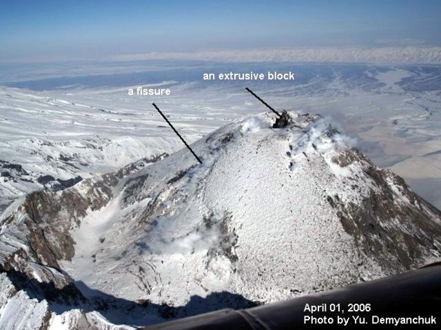 |
Figure 6. Bezymianny aerial photo taken on 1 April 2006, showing the large dome within the breached summit crater. Labels indicate both a fissure on the dome's flank and a large extrusive block (or spine) on the dome's top. Considerable areas discharged light steam. Photo by Yu. Demyanchuk and provided courtesy of KVERT. |
During 28 April to 5 May, Bezymianny's lava dome continued to grow. Seismicity was above background levels during 30 April to 3 May. Incandescent avalanches were visible on 4 May. At the lava dome, fumarolic activity occurred and thermal anomalies were visible on satellite imagery. Bezymianny was at Yellow on the four stage Concern Color Code (low to high–Green, Yellow, Orange, Red).
On 7 May the Concern Color Code was raised to Orange due to an increase in seismicity and the number of incandescent avalanches (14 occurred on 6 May in comparison to 4-6 during the previous 2 days). Intense fumarolic activity occurred, with occasional small amounts of ash. KVERT reported that an explosive eruption was possible in the next 1 or 2 weeks.
9 May eruption. On 9 May around 1935, the Concern Color Code was raised to Red, the highest level, due to increased seismicity and incandescent avalanches. A gas plume rose higher than 7 km altitude and a strong thermal anomaly was visible on satellite imagery.
An explosive eruption occurred on 9 May during 2121 to 2145. The explosion produced an ash column that rose to a height of ~ 15 km altitude. A co-ignimbrite ash plume was about 40 km in diameter and mainly extended NE of the volcano. Ash plumes extended more than 500 km ENE from the volcano. Pyroclastic flows deposits extended 7-8 km from the volcano.
On 10 May around 0100, seismicity returned to background levels and the Concern Color Code was reduced to Orange. Small fumarolic plumes were observed during the early morning of the 10th and lava probably began to flow at the lava dome.
By 11 May seismic activity was still at background levels. Gas and steam plumes were visible above the volcano. A thermal anomaly was noted at the volcano on 10-11 May. Lava effusion was probably occurring at the lava dome. This was interpreted to mean that the likelihood of a large, ash-producing eruption had diminished.
Information Contacts: Olga Girina, Kamchatka Volcanic Eruptions Response Team (KVERT), a cooperative program of the Institute of Volcanic Geology and Geochemistry, Far East Division, Russian Academy of Sciences, Piip Ave. 9, Petropavlovsk-Kamchatsky, 683006, Russia, the Kamchatka Experimental and Methodical Seismological Department (KEMSD), GS RAS (Russia), and the Alaska Volcano Observatory (USA); Alaska Volcano Observatory (AVO), a cooperative program of the U.S. Geological Survey, 4200 University Drive, Anchorage, AK 99508-4667, USA (URL: http://www.avo.alaska.edu/), the Geophysical Institute, University of Alaska, PO Box 757320, Fairbanks, AK 99775-7320, USA, and the Alaska Division of Geological and Geophysical Surveys, 794 University Ave., Suite 200, Fairbanks, AK 99709, USA.
Ongoing dome growth; 23-25 December pyroclastic flows
Except for brief heightened activity at the end of December 2006, moderate volcanic activity and seismicity has prevailed at Bezymianny since the extensive eruption in May 2006, last reported on in BGVN 31:04. This report covers activity following the 9 May 2006 explosion to the start of January 2007.
The Kamchatkan Volcano Eruption Response Team (KVERT) raised the Concern Color Code to red, the highest level, in response to the 9 May 2006 eruption (BGVN 31:04). They lowered it on 10 May to orange, and again, on 11 May to yellow, where it remained until the end of December. By 11 May, seismicity remained at or below background levels. Two shallow earthquakes were recorded on 15 and 19-20 May; five shallow earthquakes were recorded during 27-30 May. Similar low levels of seismicity were recorded during June to November 2006, with seismic activity exceeding background levels only on 14 August and 25, 27, and 30 November.
Growth of the lava dome continued during June to December 2006. Video data on 28-29 May showed weak gas-and-steam plumes. A thermal anomaly was noted during the latter part of the month (specifically, on 16-18, 23-25, 27, and 29 May). Video data showed gas-and-steam plumes rising to ~ 7.5 km altitude on 5 June and to ~ 4.0 km altitude the week of 16 June. Weak gas-and-steam plumes were observed 16 and 19-20 June. Thermal anomalies were often noted, with particularly large ones on 24 and 29 June. On days of good visibility, video data consistently showed fumarolic activity at the lava dome. An increase in size of two explosive craters at the dome's summit and a new lava flow on the dome's SW flank, thought to have resulted from the 9 May 2006 eruption, were observed on 31 July.
Seismic activity was above background levels during much of December and dramatically increased the week of 24 December. Several shallow earthquakes were registered during the weeks of 8, 15, and 22 December.
On 6 and 10 December, respectively, gas-and-steam plumes rose to ~ 4.5 and 3.5 km altitude. Satellite data recorded a thermal anomaly over the dome during the weeks of 8, 15, 22 December and on 29-31 December. The number of hot avalanches per day grew from 4-6 in previous days to 15 on 23 December.
On 23 December, starting at 2352, an explosive eruption occurred, producing ash and pyroclastic flows; a resulting ash plume rose ~ 4.5-6 km altitude and extended NE. In response to the eruption, on 24 December KVERT raised the level of Concern Color Code from yellow to orange.
Another explosive eruption started between 0917-1020 on 24 December and ended on 25 December 2006. A large eruptive column rose to ~ 13 km altitude and developed into a big umbrella cloud. According to satellite data, ash clouds extended ~ 850 km NE on the 24 and 25 December. Late on 24 December, the Concern Color Code was raised to red. According to the Russian News Agency NOVOSTI, Russian government officials instructed residents of a village 40 km E of the volcano where ash fallout occurred to avoid leaving their houses.
About 30 local seismic events occurred at the volcano during 1020-2000 on 24 December. Volcanic seismicity returned to background levels at 2000 on 24 December. According to seismic data on 25 December, two hot avalanches took place. In addition, a large thermal anomaly occurred at the lava dome. Visual and video data on 26-27 December showed moderate fumarolic activity. Photographs, taken by volcanologists who flew around the volcano in a helicopter, revealed that a portion of the lava dome was destroyed during the 24 December eruption. The Concern Color Code was lowered to orange on 25 December, and subsequently to yellow on 29 December, where it remained in early January 2007. According to satellite data collected on 31 December and 3 January, fresh deposits of pyroclastic flows extended 7-8 km SE from the volcano.
Seismic activity stood slightly above background levels on 2 January, and at background levels on the other days. According to visual and video data, moderate fumarolic activity occurred on 29-31 December, although the volcano was often obscured by clouds. A thermal anomaly was noted on 3 January.
Information Contacts: Olga A. Girina, Kamchatka Volcanic Eruptions Response Team (KVERT), a cooperative program of the Institute of Volcanic Geology and Geochemistry, Far East Division, Russian Academy of Sciences, Piip Ave. 9, Petropavlovsk-Kamchatsky, 683006, Russia, GS RAS (Russia), and the Alaska Volcano Observatory (AVO), a cooperative program of the U.S. Geological Survey, 4200 University Drive, Anchorage, AK 99508-4667, USA (URL: http://www.avo.alaska.edu/), the Geophysical Institute, University of Alaska, PO Box 757320, Fairbanks, AK 99775-7320, USA, and the Alaska Division of Geological and Geophysical Surveys, 794 University Ave., Suite 200, Fairbanks, AK 99709, USA; Russian News & Information Agency NOVOSTI, 4, Zubovsky Bulvar, 119021, Moscow, Russia (URL: http://en.rian.ru/).
Continued activity May-December 2007 with ash plumes and lava emission
As reported in BGVN 31:11, after a period of moderate volcanic activity following the extensive eruption of 9 May 2006, heightened activity occurred at Bezymianny during December 2006 before returning to moderate activity through early 2007. This report covers the period from May through December 2007. It was drawn mainly from reports of the Kamchatkan Volcanic Eruption Response Team (KVERT).
Based on satellite data from 10 May 2007, KVERT reported that a large thermal anomaly with a temperature of ~ 51°C appeared over Bezymianny's summit lava dome.
At about 0330-0400 on 12 May, an explosive eruption may have occurred, according to seismic data from Kozyrevsk. Ash plumes rose to an altitude of 4 km and were visible on satellite imagery drifting in multiple directions. Ashfall was reported in the town of Klyuchi, a spot ~ 47 km NE of the volcano. On 13 May, an elongated thermal anomaly was seen on satellite imagery to the SE of the dome, which decreased in size through 17 May. That day, hunters saw a large (200 m wide) mudflow along the Sukhaya Khapitsa river.
KVERT reported that Bezymianny seismicity was at background during May-September 2007, but increased in early October. Satellite imagery observations showed a thermal anomaly in the crater on 4, 6, 8, and 11 October; fumarolic activity was observed during 6-7 and 10-11 October. Based on seismic interpretation, a hot avalanche probably occurred on 10 October and small eruptions also occurred on 14 October.
The Tokyo Volcanic Ash Advisory Center (VAAC) reported ash plumes to altitudes of ~ 10 km on 14 October. Those of 15 October reached 7.3-9.1 km altitude and drifted E and SE. A strong thermal anomaly was present in the crater around this time. Slightly elevated seismicity occurred during 16-19 October before returning to background during19-20 October. Based on observations of NOAA satellite images by the Tokyo VAAC, a stripe of ash deposits appeared on the ESE flank by 18 October.
Based on seismicity, KVERT interpreted that a series of explosions or collapses from lava flow fronts occurred on 5 November 2007. Two avalanches and an ash plume were also detected. Satellite imagery revealed a thermal anomaly over the lava dome. According to Aleksei Ozerov, the 5 November activity was caused by dome collapse. This demolished a significant section of the SE dome, involving a total volume of almost 200,000 m3. The collapse produced a debris avalanche that traveled almost 3 km downslope.
According to a TERRA MODIS image on 9 November, a very bright (probably high temperature) gas-steam plume rose to about 35 km altitude. [This unusually tall plume height has not been confirmed.] On 10 November, KVERT reported continued growth of a viscous lava flow from the summit dome.
During an overflight around this time observers saw a 4-km-long deposit on the SE flank laid down by pyroclastic flows on 5 November. Lava flow-front collapses from older lava flows on the SE flank were also evident. Visual observations and video footage analysis indicated that gas-and-steam plumes drifted NE on 9 November and S on 13 November. Based on observations of satellite imagery, the Washington VAAC reported that an ash plume at an altitude of ~6.4 km drifted E on 15 November. Visual observations and video footage showed gas-and-steam plumes on 17 and 18 November.
Seismicity was above background during 19-20 November. A thermal anomaly occurred at the crater during 16-17 and 21 November. An ash plume reached 4.3 km altitude on 2 December. Seismicity was at background through the rest of December, except during 21-25 December, when it again rose. Ash plumes up to 4.5 km altitude and avalanches were registered on 23 December.
A paroxysmal explosive eruption occurred between 0917 and 1020 UTC on 24 December 2007 and a large column rose to ~ 13.0 km altitude. According to satellite data, ash clouds extended from the volcano over 850 km to the NE on 24-25 December. According to KVERT volcanologists, who circled the volcano by helicopter with cameras, this eruption destroyed a part of lava dome.
Information Contacts: Olga Girina, Kamchatka Volcanic Eruptions Response Team (KVERT), a cooperative program of the Institute of Volcanic Geology and Geochemistry, Far East Division, Russian Academy of Sciences, Piip Ave. 9, Petropavlovsk-Kamchatsky, 683006, Russia (URL: http://www.kscnet.ru/ivs/eng/), the Kamchatka Experimental and Methodical Seismological Department (KEMSD), GS RAS (Russia), and the Alaska Volcano Observatory (USA); Alaska Volcano Observatory (AVO), cooperative program of the U.S. Geological Survey, 4200 University Drive, Anchorage, AK 99508-4667, USA (URL: http://www.avo.alaska.edu/), the Geophysical Institute, University of Alaska, PO Box 757320, Fairbanks, AK 99775-7320, USA, and the Alaska Division of Geological and Geophysical Surveys, 794 University Ave., Suite 200, Fairbanks, AK 99709, USA; Washington Volcanic Ash Advisory Center (VAAC), Satellite Analysis Branch (SAB), NOAA/NESDIS E/SP23, NOAA Science Center Room 401, 5200 Auth Rd, Camp Springs, MD 20746, USA (URL: http://www.ospo.noaa.gov/Products/atmosphere/vaac/); Hawai'i Institute of Geophysics and Planetology (HIGP) Hot Spots System, University of Hawai'i, 2525 Correa Road, Honolulu, HI 96822, USA (URL: http://modis.higp.hawaii.edu/); Vladivostok Times (URL: http://www.vladivostoktimes.ru/).
Correction to plume description in November 2007
In BGVN 32:11, we erroneously reported a cloud height of 35 km from Bezymianny on 10 November 2007. The plume on that day was a steam plume that extended ~35 km downwind.
Reference. Cergey Ushakov, Kamchatkan and Northern Kuriles Volcanic Activity, KVERT INFORMATION RELEASE 57-07, Saturday, November 10, 2007, 03:30 UTC (15:30 KDT).
Information Contacts:
Seismicity, hot avalanches, and dome growth during July 2008
Between May and December 2007 there was increased seismic activity with ash plumes and lava emission (BGVN 32:11) at Bezymianny (figure 7). No further reports were available about this volcano until July 2008.
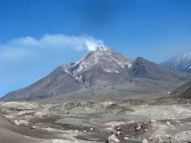 |
Figure 7. Bezymianny as seen on 20 July 2008 from the SE side. Note the prominent avalanche scarp ("crater rim") on either side of the actively growing dome and its mantling talus apron. Hummocks in the foreground terrain are signatures of the debris avalanche deposit there. Upslope of the zone of hummocks lies a delta- or fan-shaped deposit eroded from the growing dome. Courtesy of Olga Girina (KVERT). |
On 12 July 2008, the Kamchatkan Volcanic Eruption Response Team (KVERT) reported increased seismicity, with shallow earthquakes, and raised the Level of Concern Color Code to Orange. According to KVERT, intermittent volcanic tremor at Bezymianny was detected on 11 July, along with hot avalanches and strong fumarolic activity. On 11 and 15 July, satellite imagery detected weak thermal anomalies over the lava dome. On 15 July, local observers reported hot avalanches.
Seismic activity remained above background levels through 17 July (table 4), but then declined to background levels (except for a one-day increase on 20 July). Weak to moderate fumarolic activity was observed during 18-22 July. Volcanologists saw the growing dome extruding a viscous lava flow. Weak thermal anomalies over the lava dome were detected in satellite imagery on 18, 19, and 20 July. KVERT lowered the level of Concern Color Code to Yellow.
Table 4. Seismicity at Bezymianny and visual observations for the interval from 6 June to July 2008. Ks refers to a magnitude classification determined from S-wave amplitude (as defined by Sergei Fedotov). Courtesy of KVERT and Kamchatka Branch of the Geophysical Service of the Russian Academy of Sciences (KB GS RAS).
| Date | Earthquakes, Ks | Comments |
| 06 Jun 2008 | 4.0 | Obscured by clouds |
| 10 Jun 2008 | 4.3 | Obscured by clouds |
| 13 Jun 2008 | 4.2 | Obscured by clouds |
| 17 Jun 2008 | 4.3 | Obscured by clouds |
| 08 Jul 2008 | 4.0 | Obscured by clouds |
| 09 Jul 2008 | 4.7 | Obscured by clouds |
| 11 Jul 2008 | tremor | Hot avalanches, strong fumarolic activity, thermal anomaly |
| 12 Jul 2008 | Over 4.0 and one over 5.0 | Obscured by clouds |
| 13 Jul 2008 | 4.0-5.0 | Obscured by clouds |
| 14 Jul 2008 | 4.0-5.0 | Obscured by clouds |
| 15 Jul 2008 | 4.0-5.0 | Hot avalanches, thermal anomaly |
| 16 Jul 2008 | 4.0-5.0 | Obscured by clouds |
| 17 Jul 2008 | 4.0 | Explosive activity of the volcano and new pyroclastic flows, thermal anomaly |
| 20 Jul 2008 | 4.0 | An effusion of viscous lava flow at the lava dome and moderate fumarolic activity, thermal anomaly |
| 27 Jul 2008 | 4.5 | Fumarolic activity, thermal anomaly |
Reference. Fedotov, S.A., Chernisheva, G.V., and Shumilina, L.S., 1993, The estimation of the seismic danger of the earthquakes of M 6, which accompany the strong (M 8) Pacific Ocean earthquakes: Volcanology and Seismology, no. 6, p. 3-12 (in Russian).
Information Contacts: Kamchatka Volcanic Eruptions Response Team (KVERT), Institute of Volcanology and Seismology (IVS), Far East Division, Russian Academy of Sciences, Piip Ave. 9, Petropavlovsk-Kamchatsky, 683006, Russia (URL: http://www.kscnet.ru/ivs/); Olga Girina, KVERT, IV&S.
Lava dome growth and explosive 17 December 2009 eruption
Dome growth continued at Bezymianny (figure 8) in the aftermath of the extensive eruption of 9 May 2006 (BGVN 31:04), with later eruptions on 12 May 2007 (BGVN 32:11) and a previously unreported substantial one on 19 August 2008. Another one occurred on 17 December 2009. This report covers the interval from August 2008 to mid-January 2010.
 |
Figure 8. July 2009 aerial photo of Bezymianny showing the eroded outer S flank in the foreground, the dome in the mid-ground, and Kamen volcano in the distance. The fresh 2009 lava flow (black) moves down the dome towards the viewer. Courtesy of Pavel Izbekov (Alaska Geophysical Institute). |
Explosion of 19 August 2008. The explosion produced an ash plume that rose to ~ 9 km altitude and drifted 1,200 km W. Staff at a seismic station ~ 50 km W reported ashfall and the smell of volcanic gas. Analysis of satellite imagery revealed thermal anomalies on the lava dome during 14-15 and 18-21 August 2008. Moreover, the thermal anomalies enlarged just before the 19 August explosion.
Thermal images and photos. During much of the interval September to December 2009, satellite images depicted thermal anomalies of 1-2 pixels in the crater area. These occurred, for example, 21 and 30 May, and 2-4, 7, and 11-14 June 2009. After the 17 December 2009 eruption (discussed below) more pixels appeared through mid-January 2010). When the volcano was visible, weak fumarolic emissions rose 50 m and blew NE to E.
A 5 September 2009 photograph of Bezymianny (figure 9) shows the volcano's famous horseshoe-shaped crater rim formed during sector collapse in a 1956 eruption. A lava flow traveled down the steaming lava dome.
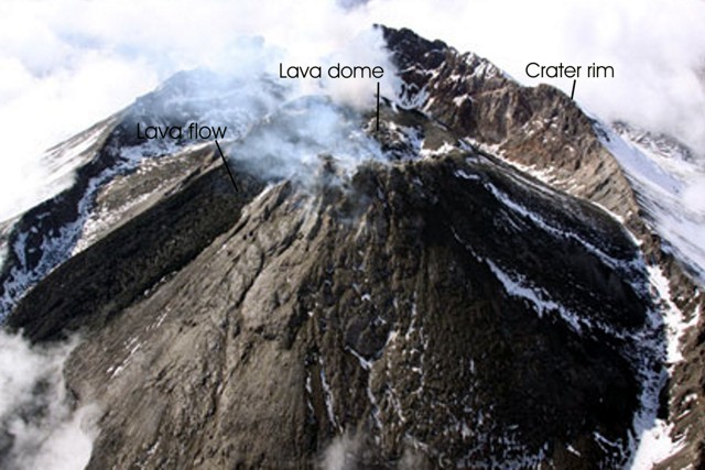 |
Figure 9. An aerial photo taken at an oblique high-angle at Bezymianny, showing active lava flows moving down slope on the dome and moderate degassing occurring at the summit. View from the E side. Photo taken 5 September 2009 by Sergey Ushakov (IV&S FED RAS). |
Seismicity. During the reporting interval, instruments recorded only a few seismic events. They took place on 13 October 2008, M 1.35 (Ks 4.2); on 5 June 2009, M 1.65 (Ks 4.8); on 24 June 2009, M 1.25 (Ks 4.0); on 5 August 2009, M 2.0 (Ks 5.5); and on 12 October 2009, M 2.1 (Ks 5.7). That said, the record of the volcano's seismicity was hard to decifer between 21 October 2008 and 16 January 2009 because of strong overriding signals from an eruption nearby at Kliuchevskoi. A large number of hypocenters were registered beneath Kliuchevskoi between 21 April and 17 November 2009 (figure 10).
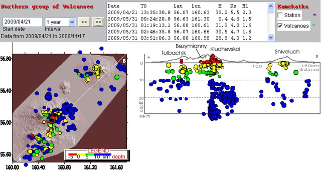 |
Figure 10. Seismicity of Kamchatka's Northern group of volcanoes (Shiveluch, Kliuchevskoi, Ushkovsky, Krestovsky, Bezymianny, Tolbachik) recorded during April-November 2009. Map (left) shows location and depths of earthquakes (white line is cross-section AB). Cross-section shows hypocenters projected onto the vertical plane along AB. Courtesy of the Kamchatka Branch of the Geophysical Service of the Russian Academy of Sciences (KB GS RAS). |
17 December 2009 eruption. Bezymianny's eruption began at 0945 on 17 December (2145 UTC on 16 December). From Atlasovo village, almost 100 km to the S, observers saw an unusually large ash cloud in a shape newspaper reporters described as reminiscent of a mushroom-cloud from a nuclear blast.
KVERT estimated the ash column height to be ~ 15 km altitude, extending to the NW, and stretching more than 350 km from the volcano. The plume's width was at least 35 km. The plume's axis passed over Kozyrevsk village where the ash thickness reached 2-3 mm (figure 11). With approach to Bezymianny, ashfall was plentiful.
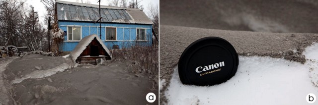 |
Figure 11. Deposit of Bezymianny ash in Kozyrevsk village area as photographed on 17 December 2009. One frame (a) shows a cottage with ash over snow-covered landscape (2-3 mm thickness); the other (b) shows close up of ash layer on top of snow. Courtesy of Yuri Demyanchuk (KVERT). |
The Geophysical Service reported that seismicity was at normal background levels during 1-5 December and gradually increased from 6 December to 16 December 2009. According to satellite data, thermal anomalies registered during 14 December 2009 to mid-January 2010 (figure 12). Thick deposits of pyroclastic flows and related tephra lay on the volcano's slopes. The large amount of material erupted suggested that a crater formed on the dome.
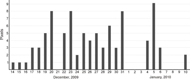 |
Figure 12. A plot showing the thermal anomalies detected at Bezymianny during 14 December 2009 to 10 January 2010. Plot made from AVO and KB GS RAS data. |
Ash plumes soon ceased, but steam was abundant. During 18 December observers noted a gas-steam emission stretching 30 km NW. On 20-22 December, steam plumes reached 10-30 km to the S.
Thermal anomalies were detected extending from the crater down onto the E flank starting at 2315 (1115 UTC) on 17 December that lasted at least 85 minutes, into the 18th. More anomalies were present during satellite passes on 21-23 December, with the last MODVOLC alerts recorded during 25-26 December 2009.
Information Contacts: Kamchatka Volcanic Eruptions Response Team (KVERT), Institute of Volcanology and Seismology (IV&S) Far East Division, Russian Academy of Sciences (FED RAS), Kamchatka Branch of the Geophysical Service of the Russian Academy of Sciences (KB GS RAS), Piip Ave. 9, Petropavlovsk-Kamchatsky, 683006, Russia (URL: http://www.kscnet.ru/ivs, http://www.emsd.ru/~ssl/monitoring/main.htm); Sergei Ushakov, IV&S FED RAS; Tokyo Volcanic Ash Advisory Center (VAAC), Tokyo, Japan (URL: http://ds.data.jma.go.jp/svd/vaac/data/); Alaska Volcano Observatory (AVO), a cooperative program of the U.S. Geological Survey, the University of Alaska's Geophysical Insitute, and the Alaska Division of Geological & Geophysical Surveys (URL: http://www.avo.alaska.edu/); Hawai'i Institute of Geophysics and Planetology (HIGP) Thermal Alerts System, School of Ocean and Earth Science and Technology (SOEST), Univ. of Hawai'i, 2525 Correa Road, Honolulu, HI 96822, USA (URL: http://modis.higp.hawaii.edu/); Pravda On-Line (URL: http://www.pravda.ru/news/accidents/19-12-2009/1004964-volcano-0/); RIA Novosti News (URL: http://www.rian.ru/).
Dome growth continues in 2012 with plumes up to 1,500 km long
This report covers ongoing dome growth and other activity at Bezymianny since our previous report in January 2010 (BGVN 34:11) and extending into early September 2012. Multiple strong eruptions occurred during this reporting period. In one case, on 2 September 2012, an eruption generated a plume that rose to 10-12 km altitude and was later detected 1,500 km from the vent. In this and many other cases, fresh lava flows were extruded at the dome. Some intervals of the remainder of 2010 and early 2011 were chiefly characterized by intermittent thermal anomalies at the dome and fumarolic activity.
The data in this report come primarily from the Kamchatka Volcanic Eruptions Response Team (KVERT) and the Tokyo Volcanic Ash Advisory Center (VAAC). Portions of this report were initially synthesized and edited by Matthew Loewen, submitted as part of a graduate student writing assignment in a volcanology class at Oregon State University under the guidance of professor Shan de Silva.
The Kamchatka peninsula's low population density often thwarts confirmation of significant events, and seismic signals were likely obscured by activity at nearby Kliuchevskoi volcano. Seismic activity and other observations between 29 January 2010 and 3 September 2012 are summarized in table 5.
Table 5. Summary of activity at Bezymianny from 29 January 2010 through 3 September 2012. Data courtesy of KVERT, Tokyo VAAC, and Anchorage VAAC.
| Date | Observations and Remarks | Aviation Color Code |
| 29-30 Jan 2010 | Thermal activity over lava dome detected by satellite. | Yellow |
| 31 Jan 2010 | Weak to moderate fumarolic activity. | Yellow |
| 02 Feb 2010 | Thermal activity deteced by satellite. | Yellow |
| 06 Feb 2010 | Weak to moderate fumarolic activity noted with possible explosions. | Yellow |
| 07-08 Feb 2010 | Hot new lava flow detected; thermal anomaly over lava dome (58.6°C). | Orange |
| 09 Feb 2010 | Explosive eruption not imminent. | Yellow |
| 16 Feb 2010 | Unconfirmed explosions. | Yellow |
| 08-13 Apr 2010 | Weak to moderate fumarolic activity, weak thermal anomaly over the lava dome. | Yellow |
| 19 May 2010 | Rapid temperature increase over lava dome from 18°C on 19 May to 49°C on 23 May. | Orange |
| 21 May 2010 | Fumarolic activity detected; continuous through 28 May. | Orange |
| 23-24 May 2010 | Earthquakes reported in location of lava dome. | Orange |
| 31 May 2010 | Strong explosion. Ash plumes rose ~8-10 km altitude and spread ~250 km W, ~160 km N and NE. Ashfall on Kozyrevsk village (45 km W) on 1 June. | Red |
| 02 Jun 2010 | Heavy gas-and-steam emissions from lava dome. Elongated thermal anomalies in satellite images the following days suggested the deposit of two pyroclastic flows. | Orange |
| 03 Jun 2010 | -- | Yellow |
| 04-05 Jun 2010 | Thermal activity detected by satellite. Ash plume drifted ~600 km SSE. | Yellow |
| 08 Jun 2010 | Thermal activity detected by satellite. | Yellow |
| 12 Jun 2010 | Thermal activity detected by satellite; slightly elevated seismicity. | Yellow |
| 12-17 Jun 2010 | Thermal activity detected by satellite. | Yellow |
| 13-16 Jun 2010 | Gas-and-steam activity. | Yellow |
| 19 Jun 2010 | Thermal anomaly detected by satellite. | Yellow |
| 21-23 Jun 2010 | Thermal anomaly detected by satellite. | Yellow |
| 28 Jun 2010 | Thermal anomaly detected by satellite. | Yellow |
| 01 Sep 2010 | Weak thermal anomaly attributed to gas-and-steam emissions. | Yellow |
| 21 Nov 2010 | Helicopter observation photos showed a new area of lava possibly extruded from the top of the dome. | Yellow |
| 03 Dec 2010 | Weak thermal anomaly attributed to gas-and-steam emissions. | Yellow |
| 07 Dec 2010 | Weak thermal anomaly attributed to gas-and-steam emissions. | Yellow |
| 30 Jan-03 Feb 2011 | Weak thermal anomaly and moderate gas-and-steam activity. | Yellow |
| 04 Feb 2011 | Based on information from Yelizovo Airport (UHPP), Tokyo VAAC reported a 4.6 km ash plume drifting to the NE. | Yellow |
| 14 Apr 2011 | Strong explosion. Ash reported at ~7.6 km altitude. | Red |
| 12-19 Feb 2012 | Increased seismicity. | Orange |
| 15 Feb 2012 | Short duration tremor activity. | Orange |
| 20 Feb 2012 | Gas-and-steam plumes drifted NE. | Orange |
| 22 Feb 2012 | Short duration tremor activity. Gas-and-steam plumes observed in satellite images drifing NE. | Orange |
| 26-29 Feb 2012 | Gas-and-steam plumes, short duration tremor. | Orange |
| 01-05 Mar 2012 | 65-80 weak seismic events. | Red |
| 08-09 Mar 2012 | Strong explosion, ash plumes to 3.5-5 km altitude, ash plumes from pyroclastic flows rose to 8 km altitude and drifted 700 km NE. Ashfall in community 120 km ENE. Followed by significant activity decrease. | Orange/Red |
| 09-13 Mar 2012 | Strong gas-and-steam emissions, viscous lava flow onto lava dome flank, thermal anomaly. | Orange/Yellow |
| 24-31 Aug 2012 | Seismicity increased to moderate (71 events on 31 Aug) with weak-to-moderate fumarolic activity; thermal anomaly. | Yellow |
| 02 Sep 2012 | Explosion with ash plumes to 10-12 km altitude, drifting 1,500 km ENE, thermal anomaly. | Orange/Red/Yellow |
| 03 Sep 2012 | Seismicity low, viscous lava flow was accompanied by fumarolic activity and hot avalanches. | Yellow |
Several abstracts discussing the June 2010 explosive eruption were presented at the Fall 2010 American Geophysical Union conference in San Francisco. These studies were primarily the work of the U.S.-Russia Partnership for Volcanological Research and Education (PIRE). Part of the initiative was to install and monitor 14 GPS stations around Bezymianny (Serovetnikov and others, 2010; their figure 4). Over the course of the five-year project, the scientists noted precursory changes in GPS-measured surface velocity. The anomalies occurred 15-25 days before, and 25-30 days after, typical eruptions, suggesting relatively short periods of shallow magma storage before eruptions. Grapenthin and others (2010) also reported that during the December 2009 and May 2010 eruptions, the 12 available GPS stations showed little or no significant inflation before explosions, suggesting the magma was deeply sourced.
Izbekov and others (2010) reported that the December 2009 and June 2010 eruptive products contained abundant high-silica, amphibole-bearing enclaves. This was in contrast to all previous eruptions since 1956. Until December 2009, the juvenile products of Bezymianny were remarkably homogeneous; enclaves and xenoliths had been exceptionally rare.
Figures 13-15 show images and photos of Bezymianny that help document the 14 April 2011 eruption, which is also noted in table 5. Several other strong eruptions took place later in the reporting interval (discussed below).
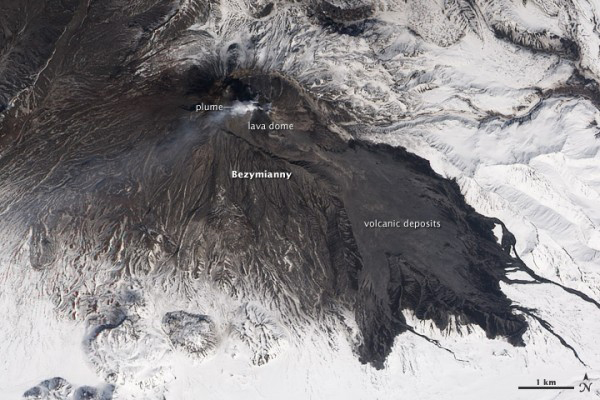 |
Figure 13. A natural-color EO-1 satellite image of Bezymianny acquired 22 April 2011 showing evidence of the size of the 14 April eruption. Dark volcanic deposits (likely a combination of pyroclastic flows and lahars) extend more than 7.3 km SW into valleys. A light-colored plume of ash, steam, and SO2 rises above the summit and drifts W. Volcanic ash covers the upper slopes of the volcano, especially to the S and W. White snow, still deep in late April, blankets the surrounding landscape as seen in figure 15. These images were acquired on 22 April 2011 by the Advanced Land Imager (ALI) aboard the Earth Observing-1 (EO-1) satellite. Caption and figure courtesy of Jesse Allen and Robert Simmons, NASA Earth Observatory. |
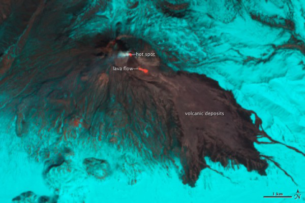 |
Figure 14. Bezymianny, as captured 22 April 2011 in an EO-1 false-color satellite image. At the summit, a red hot spot indicates where fresh lava extruded to the growing lava dome. To the SE, an active lava flow appears as a similar hot spot. In these wavelengths, bare rock and ash are gray; snow and ice appear cyan. These images were acquired near noon on 22 April 2011 by the Advanced Land Imager (ALI) aboard the Earth Observing-1 (EO-1) satellite. Caption and figure courtesy of Jesse Allen and Robert Simmons, NASA Earth Observatory. |
 |
Figure 15. Photographs depicting the ash from the 14 April 2011 eruption of Bezymianny mantling the snow base. Courtesy of KVERT. |
On 8 March 2012, KVERT raised Bezymianny's Aviation Color Code to Red after a sharp and sustained increase in seismic activity. KVERT also noted a significant increase in both the size and temperature of a thermal anomaly at the summit, suggesting that new, hot magma was very close to or at the dome's surface. Therefore, the organization suggested that "strong ash explosions up to 13 km a.s.l. were possible at any time during the next 24 hours." The following day, 9 March, Bezymainny exploded; the magnitude of the volcanic tremor was 7.52 m/s. Ash plumes from pyroclastic flows rose to 8 km in altitude and drifted NE. According to later satellite data, the ash plume was distinguishable for ~700 km. In addition, gas-and-steam plumes containing ash rose to an altitude of 3.5-4.0 km and drifted NE. Seismologists reported that the explosion did not pose a threat to population centers in the area. After the strong explosive phase, the eruptive vigor decreased gradually and continued at a low level. Following the 8-9 March event, KVERT lowered the Aviation Color Code to Orange.
During 9-13 March, video captured strong gas-and-steam emissions; no ash was noted. Strong degassing accompanied the effusion of a viscous lava flow on the S flank of the lava dome, along with moderate-to-strong gas-and-steam emissions. Seismic activity was low after 10 March, although the volcano emitted gas-and-steam plumes during 14-15 March. Satellites continued to record thermal anomalies. KVERT lowered the Aviation Color Code to Yellow.
According to visual observations during 15-16 March, the length of the 8 March 2012 pyroclastic deposits was ~4 km. According to satellite data, a thermal anomaly continued to register at the volcano on 23 and 25-26 March. Clouds obscured the volcano on other days of week.
The viscous lava flow continued to effuse on the S flank of the lava dome, accompanied by degassing, well into May. KVERT noted thermal anomalies (detected by satellite) during 29-31 March, 3-4, 9-10, 13-17, 19, 28-29 April, and 3 May. Seismic activity remained low.
According to KVERT, seismicity increased during the middle of August 2012. On 28 August, 17 events were recorded; on 31 August, 71 events were detected. Observers noted weak-to-moderate fumarolic activity during 25-26 and 29 August; cloud cover prevented observations on other days. A thermal anomaly was detected in satellite imagery on 25 August.
On 2 September, an explosion sent ash plumes to an altitude of 10-12 km; plumes drifted more than 1,500 km ENE. A thermal anomaly observed in satellite imagery was very bright before the explosion. The Aviation Color Code was raised to Orange, then Red. Later that day, ash plumes rose to an altitude of 4 km and drifted NE before ash emissions ceased. The Aviation Color Code was then lowered to Yellow. On 3 September seismic activity was low, while a viscous lava flow effused on the lava-dome flank, accompanied by fumarolic activity and hot avalanches.
References. Grapenthin, R., Freymueller, J.T., and Serovetnikov, S., 2010. The December 2009 and May 2010 eruptions of Bezymianny volcano, Kamchatka: Interpretation of the GPS Record, American Geophysical Union, Fall Meeting 2010, abstract #V33D-04.
Izbekov, P.E., Neill, O.K., Shipman, J.S., Turner, S.J., Shcherbakov, V.D., and Plechov, P., 2010. Silicic Enclaves in Products of 2009-2010 Eruptions of Bezymianny Volcano, Kamchatka: Implications for Magma Processes, American Geophysical Union, Fall Meeting 2010, abstract #V33D-01.
Serovetnikov, S., Freymueller, J.T., Titkov, N., Bahtiarov, V., and Senyukov, S,2010. GPS Monitoring Bezimyany Volcano 2006-2010 (Kamchatka), American Geophysical Union, Fall Meeting 2010, abstract #V21B-2325.
Information Contacts: Kamchatka Volcanic Eruptions Response Team (KVERT), Institute of Volcanology and Seismology (IV&S) Far East Division, Russian Academy of Sciences (FEDRAS), Kamchatka Branch of the Geophysical Service of the Russian Academy of Sciences (KBGS RAS), Piip Ave. 9, Petropavlovsk-Kamchatsky, 683006, Russia (URL: http://www.kscnet.ru/ivs/, http://www.emsd.ru/~ssl/monitoring/main.htm); Sergei Ushakov, IVS FED RAS; Tokyo Volcanic Ash Advisory Center (VAAC), Tokyo, Japan (URL: http://ds.data.jma.go.jp/svd/vaac/data/); Alaska Volcano Observatory (AVO), a cooperative program of the U.S. Geological Survey, the University of Alaska’s Geophysical Insitute, and the Alaska Division of Geological & Geophysical Surveys (URL: http://www.avo.alaska.edu/); Anchorage Volcanic Ash Advisory Center (VAAC), Alaska Aviation Weather Unit, NWS NOAA US Dept of Commerce, 6930 Sand Lake Road, Anchorage, AK 99502-1845 (URL: http://www.ssd.noaa.gov/).
Lava flows and large explosion in early 2012; dome effusion through at least mid-August 2013
Lava flows and several strong explosions at Bezymianny during early 2010 through September 2012 sent plumes as high as 10-12 km altitude (BGVN 37:08). Activity decreased afterwards, with weak-to-moderate fumarolic emissions and thermal anomalies through at least 2013. The data in this report came primarily from the Kamchatka Volcanic Eruptions Response Team (KVERT) weekly reports. Local time is UTC + 12 hours.
Thermal anomalies were recorded by MODVOLC between 19 February and 10 March 2012, and indicated lava flows descending the eastern slope (figure 16). Strong explosions 8-9 March had sent ash plumes to 3.5-5 km altitude, and ash plumes caused by pyroclastic flows went to 8 km altitude and drifted 700 km NE. Ash also fell 120 km ENE. Although there were no further explosions or MODVOLC alerts, KVERT continued to note through October that activity was moderate, with low seismicity, an effusing lava flow from the southern dome, fumarolic activity, and intermittent thermal anomalies seen in satellite data.
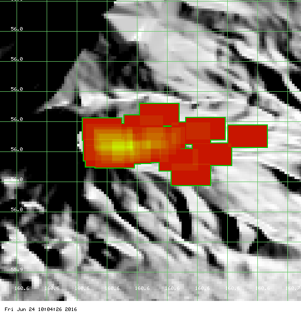 |
Figure 16. MODVOLC thermal alert pixels during 19 February-10 March 2012. Courtesy of Hawai'i Institute of Geophysics and Planetology (HIGP), MODVOLC Thermal Alerts System. |
A large explosion on 2 September 2012 explosion sent ash plumes to an altitude of 10-12 km that drifted 1,500 km ENE. Afterwards, viscous lava continued to effuse on the lava dome flank, where collapse of the lava flow front caused hot avalanches through 4 October 2012.
Activity described as effusive by KVERT continued through 17 August 2013, usually also noting that the activity was on the lava dome flank, fumarolic activity, and sometimes thermal anomalies. KVERT terminology changed to noting "moderate" rather than "effusive" activity on 22 August, but the description of the volcanism remained otherwise similar through 2013, including ongoing weak thermal anomalies over the lava dome when cloud cover allowed for satellite observations.
Information Contacts: Kamchatka Volcanic Eruptions Response Team (KVERT), Far East Division, Russian Academy of Sciences, 9 Piip Blvd., Petropavlovsk-Kamchatsky, 683006, Russia (URL: http://www.kscnet.ru/ivs/); Hawai'i Institute of Geophysics and Planetology (HIGP), MODVOLC Thermal Alerts System, School of Ocean and Earth Science and Technology (SOEST), Univ. of Hawai'i, 2525 Correa Road, Honolulu, HI 96822, USA (URL: http://modis.higp.hawaii.edu/).
Minor seismic event interpreted as lava extrusion in June 2014; incandescence in August 2014
Weekly reports issued by the Kamchatka Volcanic Eruption Response Team (KVERT) are the primary data source for activity at this remote volcano on the Kamchatka Peninsula. No thermal anomalies were reported by MODVOLC, nor were there any Volcanic Ash Advisory Reports issued, during 2014 or 2015.
KVERT described "moderate activity of the volcano" from January through mid-June 2014, and "weak" activity for the rest of 2014 and all of 2015. This was characterized by weak or no seismicity, weak or moderate gas-and-steam emissions or fumarolic activity, and weak thermal anomalies observed from satellite data on the uncommon days that the volcano was not obscured by clouds.
There were few exceptions to this characterization in 2014. During the first two weeks of May, video data revealed moderate-to-strong gas-and-steam emissions, and weak gas-and-steam emissions were reported in late May and early June, shortly before a seismic activity increase. Weak and moderate gas-and-steam activity was reported until mid-November, after which only "weak" activity was reported for the rest of 2014 and most of 2015.
On 17 June 2014, seismic activity increased and 12 shallow seismic events were recorded. This was interpreted by KVERT as an extrusion of lava at the top of the dome, and caused an increase in the Aviation Color Code from Yellow to Orange (on a four color scale of Green-Yellow-Orange-Red). Shallow seismic events were recorded for approximately three weeks, and on 17 July the Color Code was lowered back to Yellow. Weak seismic activity was reported for the rest of the year.
A visual inspection of the volcano on 17 August 2014 revealed incandescence at the summit.
Beginning on 16 January 2015, strong seismicity of neighboring Klyuchevskoy volcano obscured seismicity data at Bezymianny, so it was not reported for the rest of the year. Moderate gas-and-steam activity was observed during the week ending on 23 January, 11-16 April, and from 16 July through 3 September 2015. Otherwise, fumarolic activity was merely observed from video data. Weak thermal anomalies were reported by KVERT as observed in satellite images on clear days throughout the year.
Information Contacts: Kamchatka Volcanic Eruptions Response Team (KVERT), Far East Division, Russian Academy of Sciences, 9 Piip Blvd., Petropavlovsk-Kamchatsky, 683006, Russia (URL: http://www.kscnet.ru/ivs/)
Lava dome extrusion December 2016-April 2017; large ash explosion on 9 March 2017
The Kamchatka Volcanic Eruptions Response Team (KVERT) characterized Bezymianny as having weak activity from mid-June 2014 through the end of 2015, including weak or moderate gas-and-steam emissions (figures 17 and 18) and, when not obscured by clouds, weak thermal anomalies (BGVN 41:01). Observations here through May 2017 come from KVERT reports and Tokyo Volcanic Ash Advisory Center (VAAC) advisories.
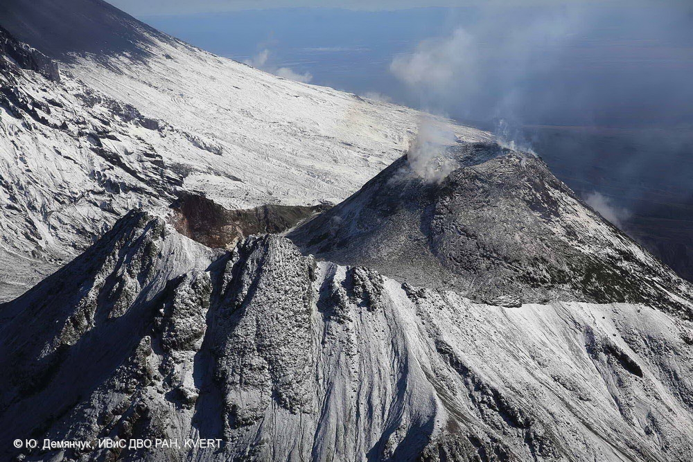 |
Figure 17. View of the summit showing fumarolic activity at Bezymianny on 16 September 2014. Photo by Yu. Demyanchuk; courtesy of IVS FEB RAS, KVERT. |
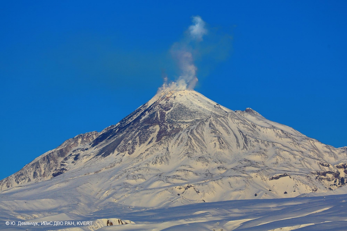 |
Figure 18. Moderate gas-and-steam activity at Bezymianny on 15 April 2015. Photo by Yu. Demyanchuk; courtesy of IVS FEB RAS, KVERT. |
Activity during 2016. KVERT reported that weak volcanic activity continued into January 2016, with moderate gas-and-steam activity through 12 December 2016. During this time, satellite data by KVERT showed a weak thermal anomaly over the volcano on most days, although on some days KVERT described the volcano as "quiet." Often the volcano was obscured by clouds.
The Tokyo VAAC reported that on 30 July an ash plume rose to an altitude of 3 km and drifted E, an observation based on information from the Yelizovo Airport (UHPP). Weak fumarolic activity continued in late August (figure 19).
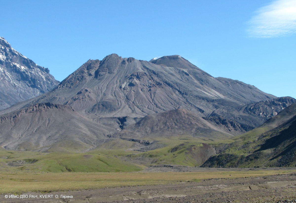 |
Figure 19. A small, weak, fumarolic plume could be seen rising from Bezymianny on 24 August 2016. Photo by O. Girina; courtesy of IVS FEB RAS, KVERT. |
Based on KB GS RAS (Kamchatka Branch of Geophysical Services, Russian Academy of Sciences) data, KVERT noted that seismicity began to increase on 18 November. The thermal anomaly temperature detected in satellite images also increased on 5 December, and then significantly increased on 13 December, probably caused by lava-dome extrusion. This activity prompted KVERT to raise the Aviation Color Code from Yellow, where it had been since 17 July 2014, to Orange (second highest level).
According to KVERT, a gas-and-steam plume containing a small amount of ash drifted about 118 km W on 15 December. The Tokyo VAAC noted that ash plumes rose as high as 6.1 km that same day. KVERT reported strong gas-and-steam emissions during 16-31 December (figure 20); a gas-and-steam plume drifted about 60 km SW on 18 December. A daily thermal anomaly was detected over the volcano.
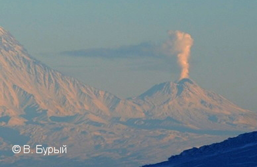 |
Figure 20. A strong gas-and-steam plume was seen rising from Bezymianny on 19 December 2016. Photo by V. Buryi; courtesy of IVS FEB RAS, KVERT. |
Activity during January-May 2017. According to KVERT, lava-dome extrusion likely continued into January 2017. Strong gas-and-steam emissions continued through 19 January 2017 and a thermal anomaly was detected over the volcano during most days. On 12 January, KVERT noted that activity had gradually decreased after an intensification during 5-24 December 2016, and thus the Aviation Color Code was lowered to Yellow. Thereafter, KVERT characterized the volcano as having moderate gas-steam activity. On 23 February, KVERT reported that the effusive eruption continued and that lava was flowing on the S flank of the lava dome.
On 9 March at about 1330, an explosive eruption occurred (figure 21). Based on webcam observations, at 1454 an ash plume rose to altitudes of 6-7 km and drifted 20 km NE. The Aviation Color Code was raised to Orange. About 30 minutes later, at 1523, an ash plume rose to altitudes of 7-8 km and drifted 60 km NW. KVERT raised the Aviation Color Code to Red, the highest level. Satellite data showed a 14-km-wide ash plume drifting 112 km NW at an altitude of 7 km. Later that day a 274-km-long ash plume identified in satellite images drifted NW at altitudes of 4-4.5 km; the majority of the leading part of the plume contained a significant amount of ash. Lava flowed down the NW part of the lava dome. The Aviation Color Code was lowered to Orange. Ash plumes drifted as far as 500 km NW.
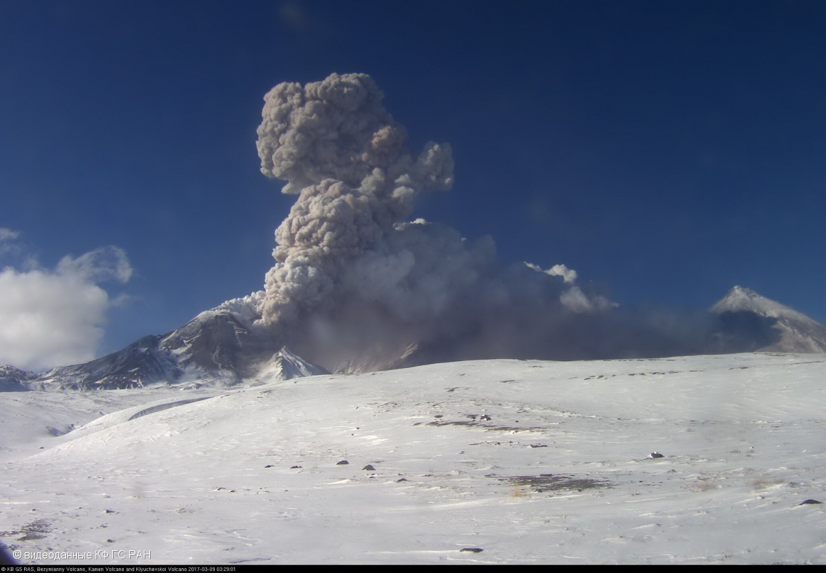 |
Figure 21. The start of an explosive eruption from Bezymianny was captured in this image taken from a webcam video on 9 March 2017. Video from KB GS RAS; courtesy of IVS FEB RAS, KVERT. |
KVERT reported that lava continued to advance down the NW flank of the lava dome during 10 March-21 April, and gas-and-steam plumes rose from the crater. A thermal anomaly was visible most days in satellite images. The Aviation Color Code was lowered to Yellow on 25 May. According to a KVERT report on 26 May, the volcano became quiet after the 9 March episode, although strong gas-and-steam emissions and daily thermal anomalies continued.
Thermal anomalies. Thermal anomalies, based on MODIS satellite instruments analyzed using the MODVOLC algorithm, were almost daily events during January through 2 November 2016, except none were reported in March through 19 May 2016. On many days, multiple pixels were reported (13 pixels on 1 September). The number of events diminished in December (only six days), and except for a brief period during 9-12 March 2017, none were reported after 20 December through at least 26 May 2017.
The Mirova (Middle InfraRed Observation of Volcanic Activity) volcano hotspot detection system, also based on analysis of MODIS data, reported several hotspots each month during May-August 2016, with a significant increase in September through early November (figure 22). Numerous hotspots were again reported in December, but only a few in January and February, except for a narrow cluster during the middle of February. In contrast to the MODIS/MODVOLC data, numerous hotspots were reported in March, April, and May 2017. The vast majority of hotspots during the past 12 months were within 5 km of the volcano and were of low power.
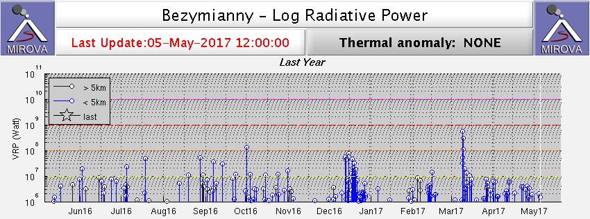 |
Figure 22. Thermal anomalies at Bezymianny recorded by the MIROVA system (log radiative power) for the year ending 5 May 2017. Note stronger frequent activity in the second half of December 2016 and the stronger anomalies associated with the March 2017 activity. Courtesy of MIROVA. |
Information Contacts: Kamchatka Volcanic Eruptions Response Team (KVERT), Far Eastern Branch, Russian Academy of Sciences, 9 Piip Blvd., Petropavlovsk-Kamchatsky, 683006, Russia (URL: http://www.kscnet.ru/ivs/kvert/); Institute of Volcanology and Seismology, Far Eastern Branch, Russian Academy of Sciences (IVS FEB RAS), 9 Piip Blvd., Petropavlovsk-Kamchatsky 683006, Russia (URL: http://www.kscnet.ru/ivs/eng/); Kamchatka Branch of the Geophysical Service, Russian Academy of Sciences (KB GS RAS) (URL: http://www.emsd.ru/); Tokyo Volcanic Ash Advisory Center (VAAC), 1-3-4 Otemachi, Chiyoda-ku, Tokyo, Japan (URL: http://ds.data.jma.go.jp/svd/vaac/data/); Hawai'i Institute of Geophysics and Planetology (HIGP) - MODVOLC Thermal Alerts System, School of Ocean and Earth Science and Technology (SOEST), Univ. of Hawai'i, 2525 Correa Road, Honolulu, HI 96822, USA (URL: http://modis.higp.hawaii.edu/); MIROVA (Middle InfraRed Observation of Volcanic Activity), a collaborative project between the Universities of Turin and Florence (Italy) supported by the Centre for Volcanic Risk of the Italian Civil Protection Department (URL: http://www.mirovaweb.it/).
Eruption continues with ash plumes and lava flows through December 2017
An eruption at Bezymianny continued into April 2017 with ash plumes and lava flows (BGVN 42:06). Similar activity was reported from May through December 2017. Observations came from reports from the Kamchatka Volcanic Eruptions Response Team (KVERT) and Tokyo Volcanic Ash Advisory Center (VAAC) advisories.
KVERT reported on 26 May that activity had decreased after an explosion on 9 March and the effusion of several lava flows onto the dome flanks. Though gas-and-steam emissions continued, along with thermal anomalies identified in satellite images. The Aviation Color Code (ACC) was lowered to Yellow (the second lowest level on a four-color scale). Moderate gas-and-steam emissions continued throughout the reporting period.
On 15 June KVERT reported that the temperature of a thermal anomaly identified in satellite images had increased, and that the webcam recorded a gas-and-steam plume rising to an altitude of 4 km and drifting SSE. Hot avalanches of material originated from the lava dome. The next day, 16 June, a powerful explosion began at 1653 (local) that produced an ash cloud that rose to an altitude as high as 12 km and drifted 700 km E and SE. Nighttime incandescence from the lava dome was observed afterwards, and a lava flow emerged from the W flank of the dome. The ACC was raised to Red (the highest level on a four-color scale), but lowered back to Orange (the second highest level) about 5 hours later. At 2110 (local) the ash cloud was 212 x 115 km in size and drifting E; the leading edge of the cloud was about 245 km E. Strong gas-and-steam emissions and incandescence above the lava dome could be seen on 18 June (figure 23).
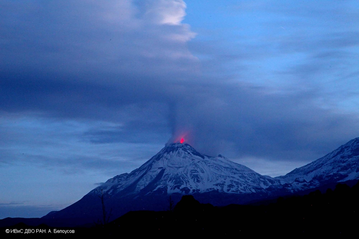 |
Figure 23. Photo of Bezymianny on 18 June 2017 showing the plume from a strong gas-and-steam emission, along with incandescence over the lava dome. Courtesy of A. Belousov, IVS FEB RAS. |
During 20 June-29 September a daily thermal anomaly over Bezymianny was identified by KVERT in satellite images, when not obscured by clouds. A lava flow continued down the W flank of the dome, and incandescence from the dome was usually visible at night. Moderate gas-and-steam activity continued.
According to KVERT, by the first week of October the volcano had quieted somewhat, although moderate gas-steam activity continued. KVERT reported that a lava flow continued down the W flank of the lava dome through 4 October, but no mention was made of a lava flow in their reports after 4 October. Weak daily thermal anomalies were recorded when the volcano was not obscured by clouds. On 5 October, the ACC was lowered to Yellow.
On 18 December hot avalanches on the SE flank of the lava dome were recorded by a webcam, prompting KVERT to raise the ACC to Orange. A strong explosion that started at 1555 (local) on 20 December generated ash plumes that rose to an altitude of 10-15 km, prompting KVERT to raise the ACC to Red. Ash plumes identified in satellite data drifted at least 320 km NE. Later that day satellite images indicated decreased activity; the ACC was lowered back to Orange. Moderate gas-and-steam emissions continued on 29 December, and a lava flow likely effused onto the N flank of the lava dome. Thermal anomalies continued to be identified in satellite images. The ACC was lowered to Yellow.
Thermal anomalies. During May-December 2017 thermal anomalies, based on MODIS satellite instruments analyzed using the MODVOLC algorithm, were only observed during a small portion of June and July 2017 (most days between 19-26 June, most days during the first week of July, 17-18 July, and 28 July). In contrast, the MIROVA (Middle InfraRed Observation of Volcanic Activity) system detected numerous hotspots every month, with the most intense cluster during the middle of June through the middle of September. Virtually all MIROVA hotspots were within 5 km of the summit.
Information Contacts: Kamchatka Volcanic Eruptions Response Team (KVERT), Far Eastern Branch, Russian Academy of Sciences, 9 Piip Blvd., Petropavlovsk-Kamchatsky, 683006, Russia (URL: http://www.kscnet.ru/ivs/kvert/); Institute of Volcanology and Seismology, Far Eastern Branch, Russian Academy of Sciences (IVS FEB RAS), 9 Piip Blvd., Petropavlovsk-Kamchatsky 683006, Russia (URL: http://www.kscnet.ru/ivs/eng/); Kamchatka Branch of the Geophysical Service, Russian Academy of Sciences (KB GS RAS) (URL: http://www.emsd.ru/); Tokyo Volcanic Ash Advisory Center (VAAC), 1-3-4 Otemachi, Chiyoda-ku, Tokyo, Japan (URL: http://ds.data.jma.go.jp/svd/vaac/data/); Hawai'i Institute of Geophysics and Planetology (HIGP) - MODVOLC Thermal Alerts System, School of Ocean and Earth Science and Technology (SOEST), Univ. of Hawai'i, 2525 Correa Road, Honolulu, HI 96822, USA (URL: http://modis.higp.hawaii.edu/); MIROVA (Middle InfraRed Observation of Volcanic Activity), a collaborative project between the Universities of Turin and Florence (Italy) supported by the Centre for Volcanic Risk of the Italian Civil Protection Department (URL: http://www.mirovaweb.it/).
Ongoing low-level thermal anomalies during January-June 2018
Activity at Bezymianny has been frequent over the past 60 years, and almost continuous since May 2010. The Kamchatka Volcanic Eruptions Response Team (KVERT) reported that ash plumes from the 20 December 2017 explosive eruption (BGVN 43:01) rose as high as 15 km and drifted 320 km NE (figure 24). On 29 December activity included moderate gas-and-steam emissions; a lava flow likely continued to effuse onto the N flank of the lava dome. A thermal anomaly over the volcano was identified in satellite images in late December 2017.
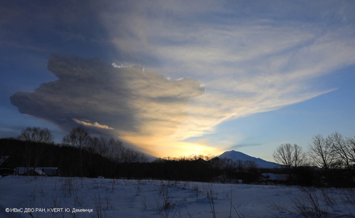 |
Figure 24. Explosions from Bezymianny sent ash plumes up to 15 km altitude on 20 December 2017. Photo by Yu. Demyanchuk; courtesy of IVS FEB RAS, KVERT. |
KVERT reported on 5 April 2018 that moderate gas-and-steam activity was continuing. Satellite data showed a thermal anomaly over the volcano on 29-30 March and 2-3 April, but the volcano was obscured by clouds in the other days of week. Fumarolic plumes were also seen on 13 April (figure 25). No MODVOLC thermal alerts were measured during the first half of 2018, and MIROVA analysis shows only low level radiative power anomalies for the same period (figure 26).
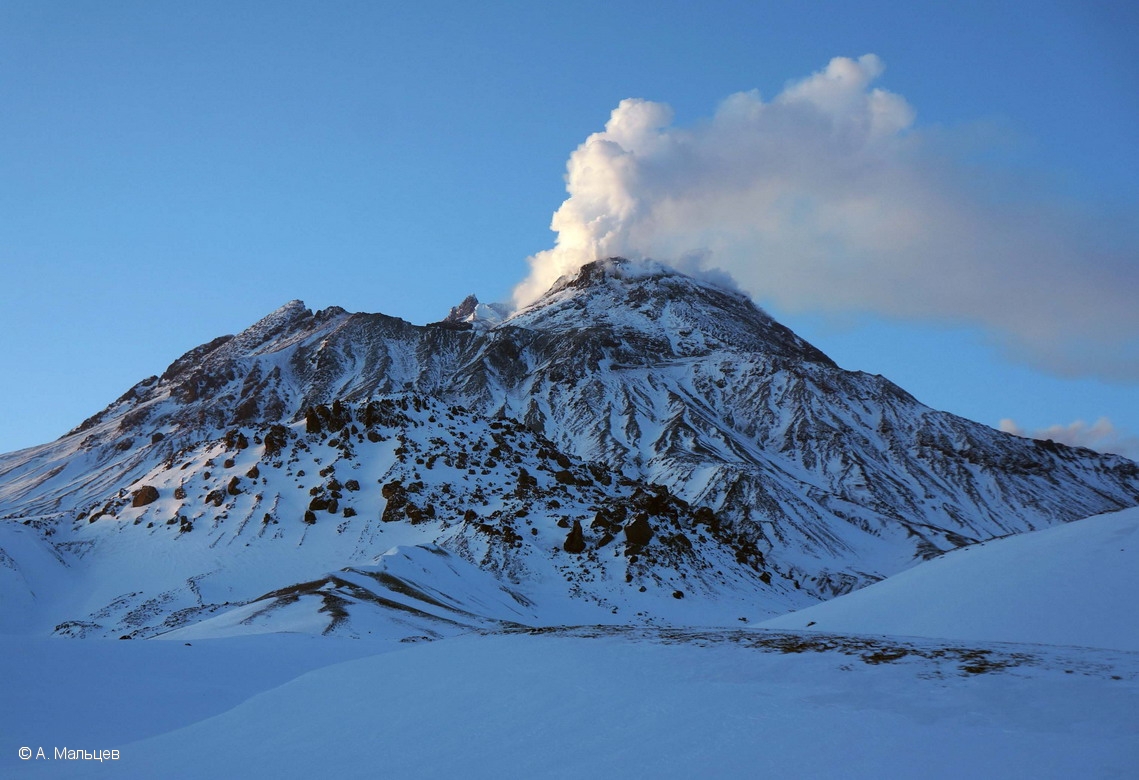 |
Figure 25. Fumarolic plume rising from Bezymianny on 13 April 2018. Photo by A. Maltsev; courtesy of IVS FEB RAS, KVERT. |
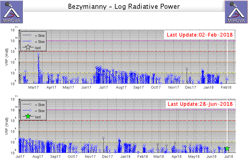 |
Figure 26. Thermal anomalies at Bezymianny recorded by the MIROVA system (log radiative power) for the year ending 2 February 2018 (top) and 28 June 2018 (bottom). Courtesy of MIROVA. |
Information Contacts: Kamchatka Volcanic Eruptions Response Team (KVERT), Far Eastern Branch, Russian Academy of Sciences, 9 Piip Blvd., Petropavlovsk-Kamchatsky, 683006, Russia (URL: http://www.kscnet.ru/ivs/kvert/); Institute of Volcanology and Seismology, Far Eastern Branch, Russian Academy of Sciences (IVS FEB RAS), 9 Piip Blvd., Petropavlovsk-Kamchatsky 683006, Russia (URL: http://www.kscnet.ru/ivs/eng/); Hawai'i Institute of Geophysics and Planetology (HIGP) - MODVOLC Thermal Alerts System, School of Ocean and Earth Science and Technology (SOEST), Univ. of Hawai'i, 2525 Correa Road, Honolulu, HI 96822, USA (URL: http://modis.higp.hawaii.edu/); MIROVA (Middle InfraRed Observation of Volcanic Activity), a collaborative project between the Universities of Turin and Florence (Italy) supported by the Centre for Volcanic Risk of the Italian Civil Protection Department (URL: http://www.mirovaweb.it/).
Ongoing low-level thermal anomalies during July 2018-January 2019; some strong ash explosions
Volcanic activity at Bezymianny has been frequent for the past 60 years, and almost continuous since May 2010. Moderate gas-steam activity and thermal anomalies were reported during the majority of this reporting period from July 2018 through January 2019 with one explosive event reported in 20 January 2019 (figure 28). Weekly data for this reporting period was provided by the Kamchatka Volcanic Eruptions Response Team (KVERT), during which the Aviation Color Code (ACC) remained at Yellow (the second lowest level in a four color alert code).
Moderate gas-and-steam activity was reported during this period from the beginning of July 2018 (figure 27) through 20 January 2019, although cloud cover frequently obscured views. On 20 July 2018, KVERT reported that satellite data showed an ash cloud that drifted for about 100 km SE. Another strong explosive eruption at 1610 UTC on 20 January 2019 resulted in an ash plume that rose to 10-11 km and drifted for about 870 km NW (figure 28).
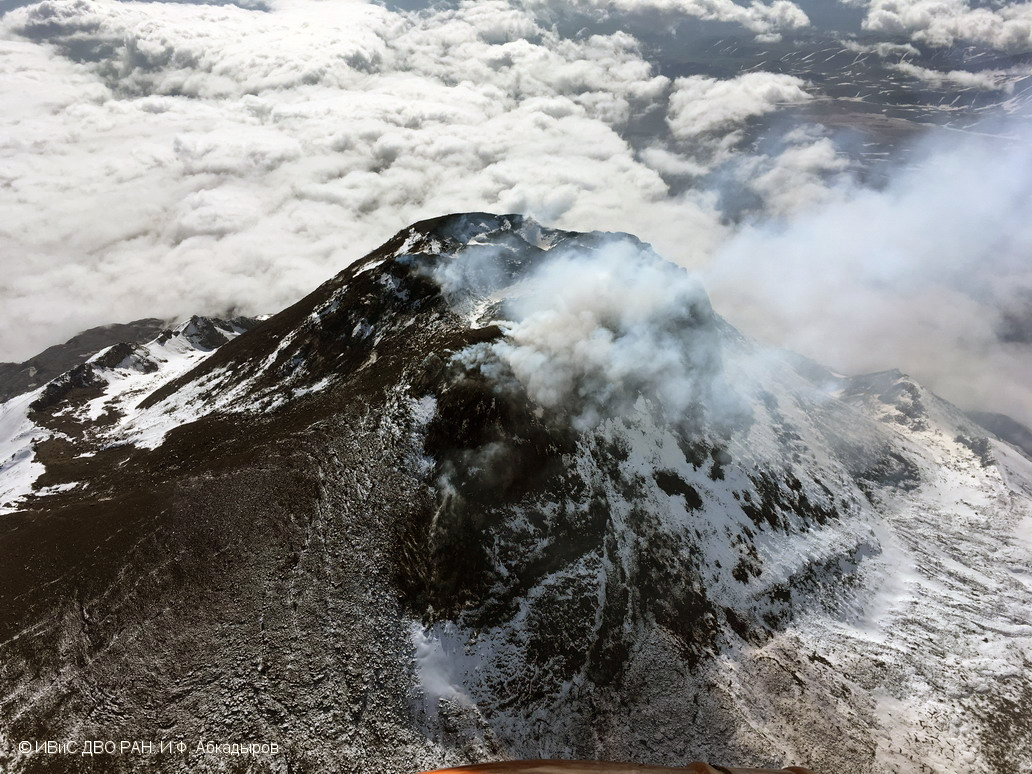 |
Figure 27. Aerial photo showing the lava dome at Bezymianny on 9 July 2018. Photo by I. F. Abkadryov, courtesy of Institute of Volcanology and Seismoloty FEB, IVS FEB RAS, KVERT. |
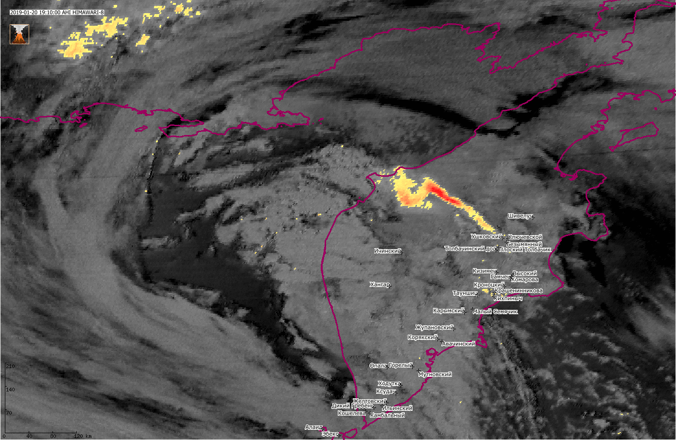 |
Figure 28. Himawari-8 satellite image showing the ash plume from an explosive eruption at Bezymianny extending W across the Kamchatka Peninsula at 1910 UTC on 20 January 2019. Data from VolSatView information system; courtesy of Institute of Volcanology and Seismology IVS FEB RAS, KVERT. |
A thermal anomaly at the volcano was reported by KVERT throughout this period. MODIS infrared satellite data processed by MIROVA showed low-power thermal anomalies over the previous year, with an increase in frequency and power during 22-27 January 2019 (figure 29).
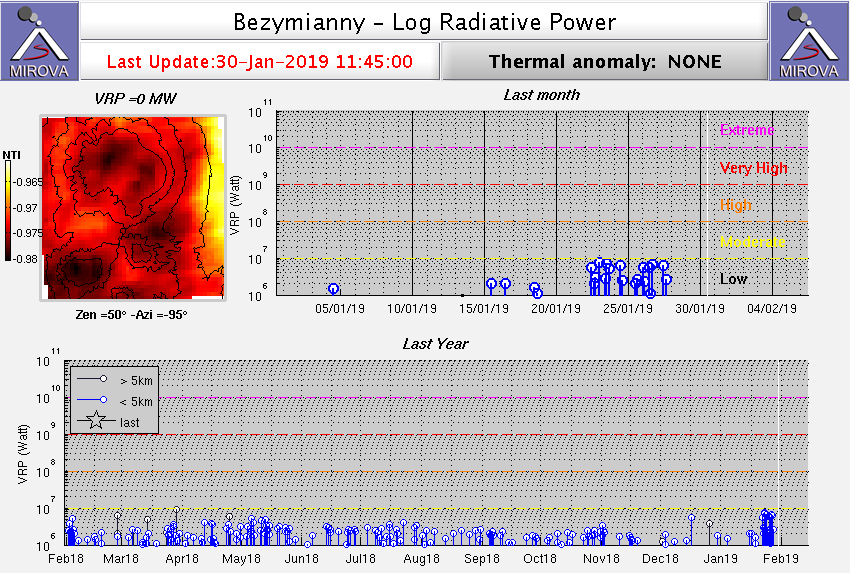 |
Figure 29. Thermal anomalies at Beymianny for the year ending 30 January 2019 recorded by the MIROVA system (log radiative power). Courtesy of MIROVA. |
Information Contacts: Kamchatka Volcanic Eruptions Response Team (KVERT), Far Eastern Branch, Russian Academy of Sciences, 9 Piip Blvd., Petropavlovsk-Kamchatsky, 683006, Russia (URL: http://www.kscnet.ru/ivs/kvert/); Institute of Volcanology and Seismology, Far Eastern Branch, Russian Academy of Sciences (IVS FEB RAS), 9 Piip Blvd., Petropavlovsk-Kamchatsky 683006, Russia (URL: http://www.kscnet.ru/ivs/eng/); MIROVA (Middle InfraRed Observation of Volcanic Activity), a collaborative project between the Universities of Turin and Florence (Italy) supported by the Centre for Volcanic Risk of the Italian Civil Protection Department (URL: http://www.mirovaweb.it/).
Ongoing thermal anomalies, gas-and-steam plumes, and lava dome growth during February-May 2019; strong explosion in mid-March
Volcanism at Bezymianny has been frequent since 1955. During the last reporting period, observations primarily consisted of moderate gas-and-steam emissions and thermal anomalies. Lava dome growth has been reported, as well as the effusion of several lava flows onto the dome flanks. Monitoring is the responsibility of the Kamchatka Volcano Eruptions Response Team (KVERT). Activity during February to mid-March 2019 consisted of predominantly moderate gas-and-steam emissions. Incandescent, hot avalanches from the lava dome, strong fumarolic activity, and a thermal anomaly began to occur in mid-March 2019. This reporting period includes activity from February-May 2019.
One explosion occurred during this reporting period. According to video data from KVERT and seismic data from the Kamchatka Branch of the Geophysical Service, on 15 March 2019 an explosion sent ash up to an altitude of 15 km. According to the KVERT Weekly Reports, satellite data showed large ash clouds from this eruption drifting several thousands of kilometers east from the volcano. The Volcano Observatory Notice for Aviation (VONA) issued by KVERT for this event described ash clouds to a distance of about 870 km. Ashfall was reported in Ust'-Kamchatsk (115 km E) on 15 March and Nikolskoe (350 km E) on 15-16 March 2019.
Beginning 15 March and continuing through May 2019, the number of hot avalanches from the lava dome top significantly increased, as well as the temperature of the thermal anomalies as reported by KVERT based on satellite data. Incandescent lava dome growth with extruding, viscous lava flows accompanying strong fumarolic activity and thermal anomalies continued in late April-May 2019 (figure 30).
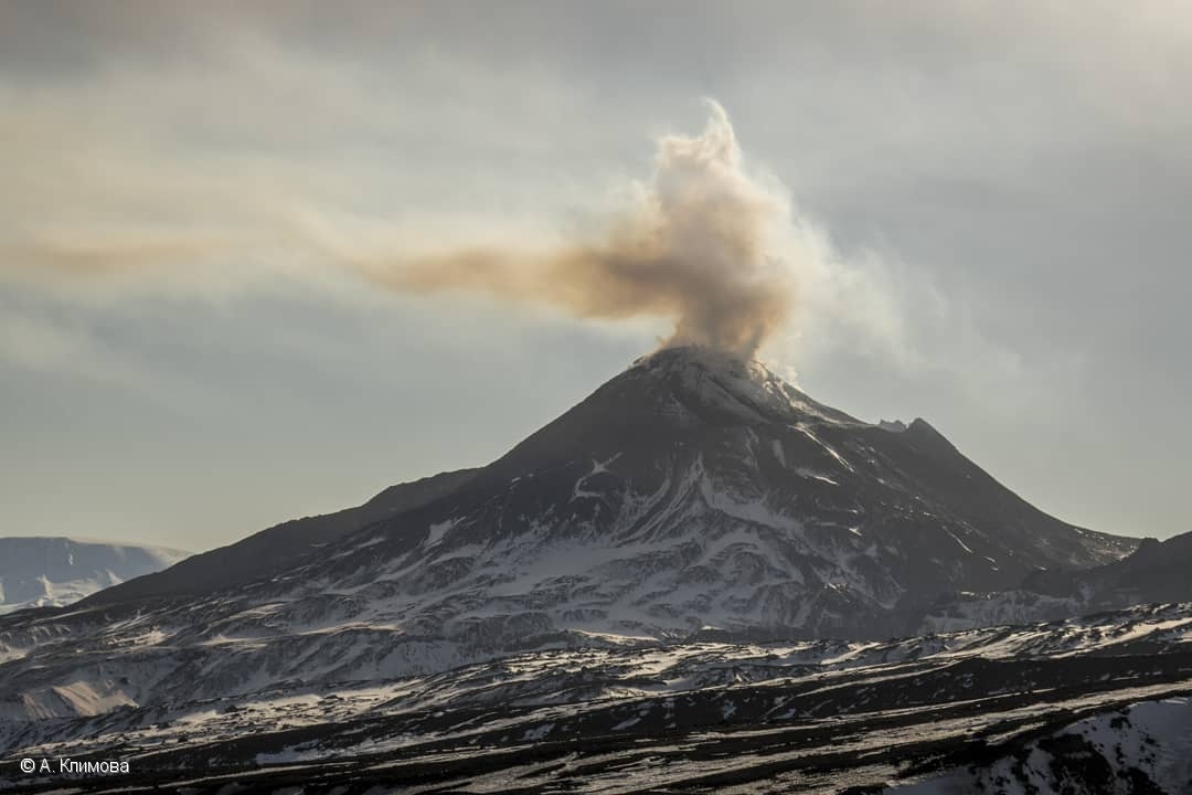 |
Figure 30. Fumarolic plume rising above at Bezymianny on 14 April 2019. Photo by A. Klimova, courtesy of the Institute of Volcanology and Seismology FEB RAS, KVERT. |
MODIS infrared data processed by MIROVA showed stronger and more frequent thermal anomalies in mid-March 2019 compared to the typical thermal activity since late January and afterwards through May (figure 31). According to the MODVOLC algorithm, 11 hotspot pixels were recorded between February and May 2019.
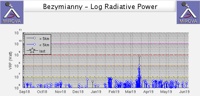 |
Figure 31. Thermal anomalies at Bezymianny for September 2018 through May 2019 as recorded by the MIROVA system (Log Radiative Power). Courtesy of MIROVA. |
Information Contacts: Kamchatka Volcanic Eruptions Response Team (KVERT), Far Eastern Branch, Russian Academy of Sciences, 9 Piip Blvd., Petropavlovsk-Kamchatsky, 683006, Russia (URL: http://www.kscnet.ru/ivs/kvert/); Institute of Volcanology and Seismology, Far Eastern Branch, Russian Academy of Sciences (IVS FEB RAS), 9 Piip Blvd., Petropavlovsk-Kamchatsky 683006, Russia (URL: http://www.kscnet.ru/ivs/eng/); Kamchatka Branch of the Geophysical Service, Russian Academy of Sciences (KB GS RAS) (URL: http://www.emsd.ru/); MIROVA (Middle InfraRed Observation of Volcanic Activity), a collaborative project between the Universities of Turin and Florence (Italy) supported by the Centre for Volcanic Risk of the Italian Civil Protection Department (URL: http://www.mirovaweb.it/); Hawai'i Institute of Geophysics and Planetology (HIGP) - MODVOLC Thermal Alerts System, School of Ocean and Earth Science and Technology (SOEST), Univ. of Hawai'i, 2525 Correa Road, Honolulu, HI 96822, USA (URL: http://modis.higp.hawaii.edu/).
Lava dome growth, ongoing thermal anomalies, moderate gas-steam emissions, June-November 2019
The long-term activity at Bezymianny has been dominated by almost continuous thermal anomalies, moderate gas-steam emissions, dome growth, lava flows, and an occasional ash explosion (BGVN 44:06). The volcano is monitored by the Kamchatka Volcanic Eruptions Response Team (KVERT. Throughout the reporting period of June to November 2019, the Aviation Colour Code remained Yellow (second lowest of four levels).
According to KVERT weekly reports, lava dome growth continued in June through mid-July 2019. Thereafter the reports did not mention dome growth, but indicated that moderate gas-and-steam emissions (figure 32) continued through November. The MIROVA (Middle InfraRed Observation of Volcanic Activity) volcano hotspot detection system, based on analysis of MODIS data, detected hotspots within 5 km of the summit almost every day. KVERT also reported a thermal anomaly over the volcano almost daily, except when it was obscured by clouds. Infrared satellite imagery often showed thermal anomalies generated by lava flows or dome growth (figure 33).
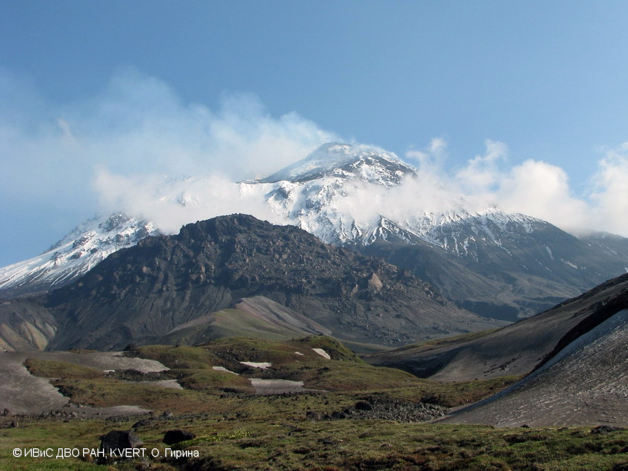 |
Figure 32. Photo of Bezymianny showing fumarolic activity on 4 July 2019. Photo by O. Girina (IVS FEB RAS, KVERT); courtesy of KVERT. |
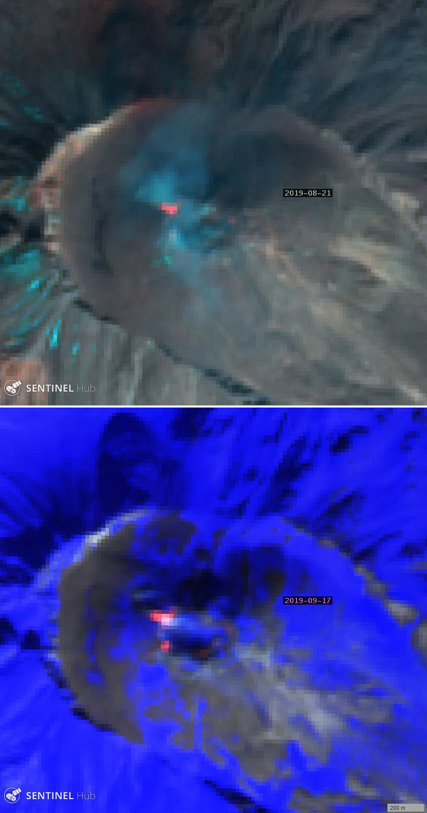 |
Figure 33. Typical infrared satellite images of Bezymianny showing thermal anomalies in the summit crater, including a lava flow to the WNW. Top: 21 August 2019 with SWIR filter (bands 12, 8A, 4). Bottom: 17 September 2019 with Atmospheric Penetration filter (bands 12, 11, 8A). Courtesy of Sentinel Hub Playground. |
Information Contacts: Kamchatka Volcanic Eruptions Response Team (KVERT), Far Eastern Branch, Russian Academy of Sciences, 9 Piip Blvd., Petropavlovsk-Kamchatsky, 683006, Russia (URL: http://www.kscnet.ru/ivs/kvert/); Institute of Volcanology and Seismology, Far Eastern Branch, Russian Academy of Sciences (IVS FEB RAS), 9 Piip Blvd., Petropavlovsk-Kamchatsky 683006, Russia (URL: http://www.kscnet.ru/ivs/eng/); MIROVA (Middle InfraRed Observation of Volcanic Activity), a collaborative project between the Universities of Turin and Florence (Italy) supported by the Centre for Volcanic Risk of the Italian Civil Protection Department (URL: http://www.mirovaweb.it/); Sentinel Hub Playground (URL: https://www.sentinel-hub.com/explore/sentinel-playground).
Lava dome growth and thermal anomalies during December 2019-October 2020; ash explosion on 22 October
Bezymianny has had frequent eruptions dating back to 1955, which has more recently consisted of ongoing low-level thermal anomalies, gas-and-steam emissions, lava dome growth, and occasional ash explosions (BGVN 44:06 and 44:12). Volcanism during December 2019 to October 2020 was characterized by primarily nighttime crater incandescence and strong fumarolic emissions, as well as a lava flow during December 2019 and an ash explosion during October 2020. Information comes from the Kamchatka Volcano Eruptions Response Team (KVERT), the Tokyo Volcanic Ash Advisory Center (VAAC), and satellite data.
Volcanism during December 2019 consisted of strong fumarolic activity, accompanied by a persistent thermal anomaly above the lava dome. On 7 October a gas-and-steam plume containing some amount of ash rose 5.5 km altitude and drifted SE according to the Kamchatka Branch of the Geophysical Service. Starting on 11 December nighttime crater incandescence was observed due to the presence of a lava flow (figure 34); the temperature of the thermal anomaly gradually began to increase. On 20 December a small lava flow was observed on the W flank of the lava dome, accompanied by a strong fumarole.
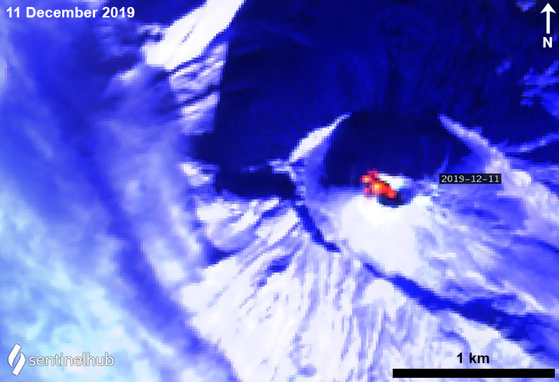 |
Figure 34. Sentinel-2 thermal satellite image showing a strong thermal anomaly over the lava dome at Bezymianny and spilling to the W flank on 11 December 2019. Sentinel-2 satellite image with “Atmospheric penetration” (bands 12, 11, 8A) rendering; courtesy of Sentinel Hub Playground. |
After the thermal activity occurred in December, volcanism significantly decreased through the end of the year, which included the temperature of the thermal anomaly; nighttime lava dome incandescence was no longer visible. Moderate gas-and-steam emissions continued frequently during the first seven months of 2020, in addition to a weaker, yet consistent, thermal anomaly over the lava dome, as seen in Sentinel-2 satellite images (figures 35 and 36).
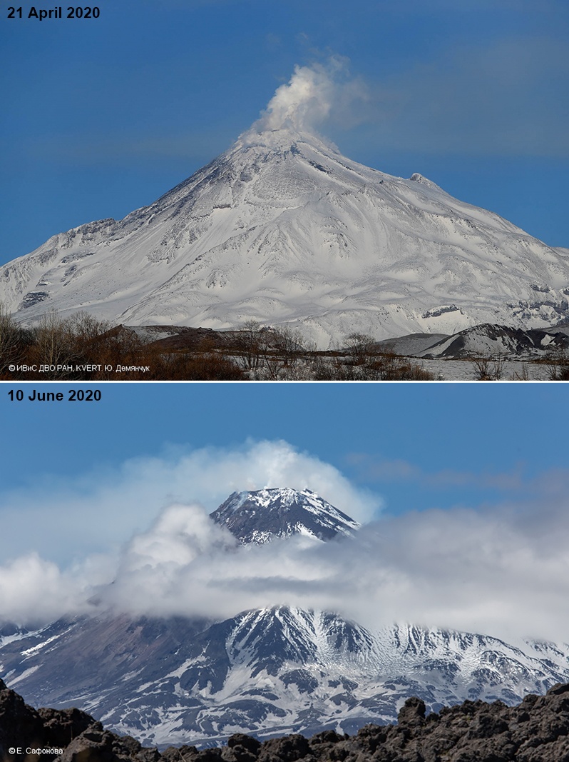 |
Figure 35. Photos of Bezymianny showing primarily strong fumarolic activity on 21 April looking N (top) and 10 June looking SE (bottom) 2020. Photos by Yu. Demyanchuk (21 April 2020) and E. Saphonova (10 June 2020); courtesy of IVS FEB RAS, KVERT. |
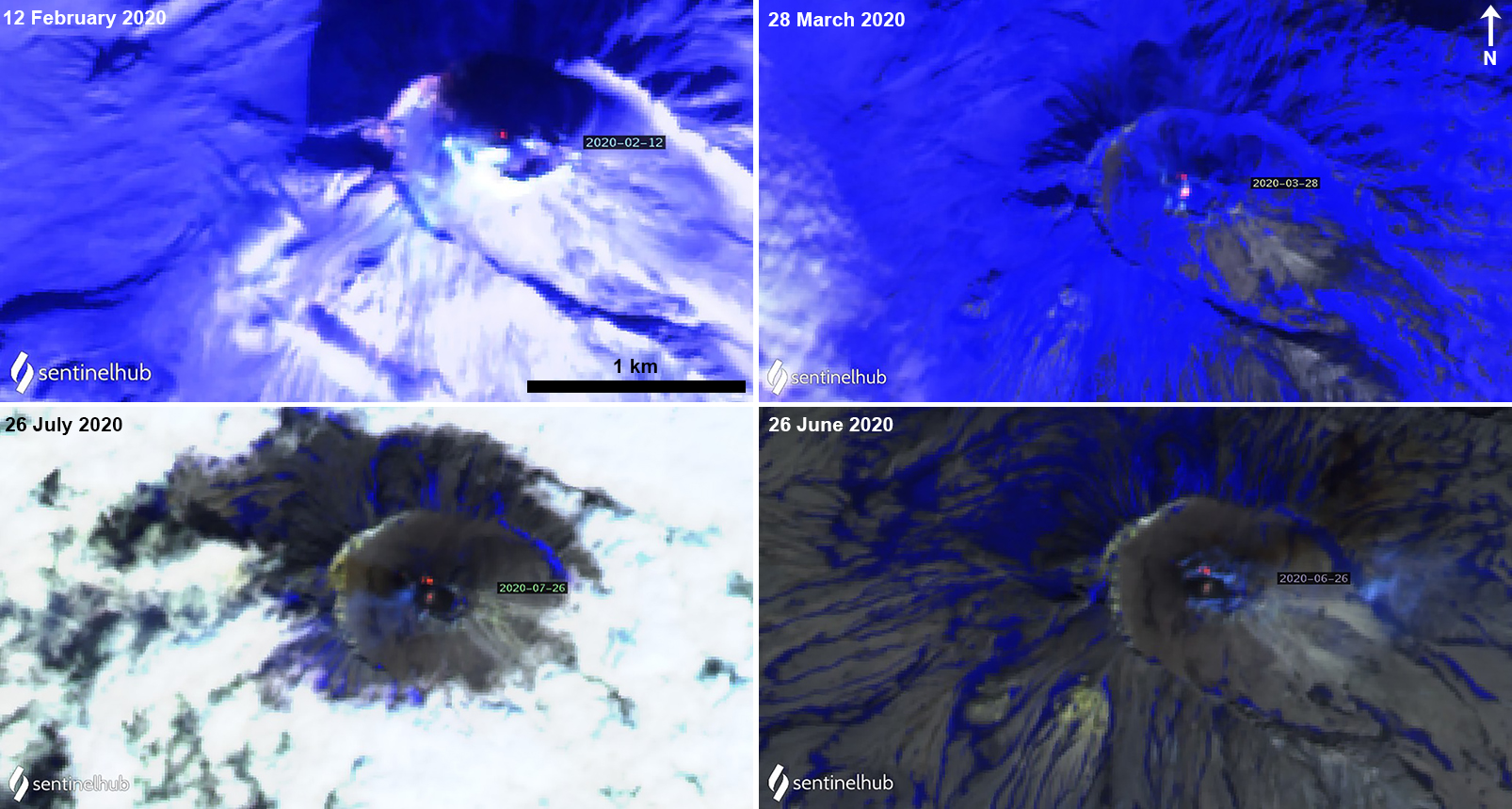 |
Figure 36. Sentinel-2 thermal satellite images showing a persistent thermal anomaly over the lava dome at Bezymianny from February through June 2020. Sentinel-2 satellite images with “Atmospheric penetration” (bands 12, 11, 8A) rendering; courtesy of Sentinel Hub Playground. |
On 26 August a new lava dome was observed growing in the summit crater, according to KVERT (figure 37). Lava dome growth continued through October, coincident with an increase in the strength and size of the thermal anomaly seen in Sentinel-2 thermal satellite imagery (figure 38). Low-level activity consisting of strong fumaroles persisted through September. Activity in early October was characterized by continued moderate gas-and-steam activity and a visible thermal anomaly over the lava dome.
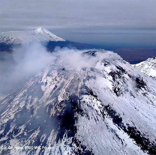 |
Figure 37. Photo of the new lava dome growing in the summit crater of Bezymianny on 26 August 2020. Photo by I. Sesterov, KSRS ME; courtesy of IVS FEB RAS, KVERT. |
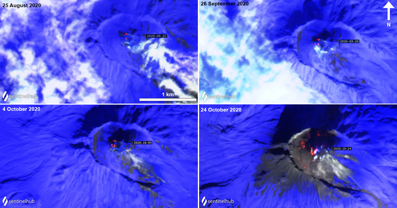 |
Figure 38. Sentinel-2 thermal satellite images showing a strong thermal anomaly over the lava dome at Bezymianny from late August and its continual growth through October 2020. Sentinel-2 satellite images with “Atmospheric penetration” (bands 12, 11, 8A) rendering; courtesy of Sentinel Hub Playground. |
On 22 October at 0822 (local time) explosive eruptions produced a large ash plume that rose 9 km altitude and measured 100 x 200 km in size (figure 39). The eruption was over by 1519, though the ash plume continued to be visible up to 5-5.5 km altitude, splitting into a N (57 x 105 km) and S (36 x 67 km) part and drifting more than 800 km NW and SE. By 24 October the ash clouds had dispersed. The lava dome continued to grow through the end of the month, accompanied by strong fumarolic activity. During 22-24 and 27-29 October the N part of the lava dome was activity and possibly advanced. On 30 October an active lava flow was observed on the N flank of the lava dome, accompanied by a strong thermal anomaly, which could also be seen in thermal satellite imagery.
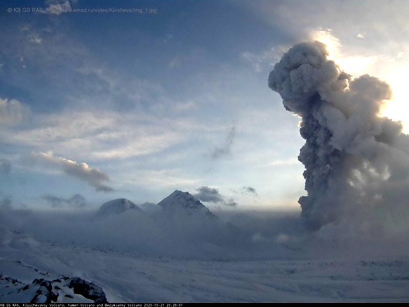 |
Figure 39. Webcam image of an eruptive column rising 9 km altitude from Bezymianny on 22 October 2020, local time with Klyuchevskoy in the background. Video image from KB GS RAS; courtesy of IVS FEB RAS, KVERT. |
The MIROVA (Middle InfraRed Observation of Volcanic Activity) volcano hotspot detection system based on analysis of MODIS data showed a pulse in thermal activity during December 2019 due to the presence of a lava flow on the W flank of the lava dome (figure 40). A second pulse of intermittent activity was detected during February through early June 2020, which was also seen occasionally in Sentinel-2 thermal satellite imagery (figure 36). Finally, a third pulse of more frequent and strong thermal anomalies occurred from late August through October, which were also clearly visible in thermal satellite imagery (figure 38). According to the MODVOLC thermal algorithm, two thermal hotspots were detected on 12 December 2019 and 23 October 2020, both of which marked the presence of the lava flow on the W flank of the lava dome and the ash explosion, respectively.
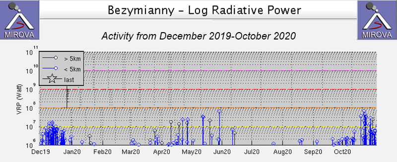 |
Figure 40. Thermal anomalies at Bezymianny recorded by the MIROVA system (Log Radiative Power) from December 2019 through October 2020 show a pulse in thermal activity during December 2019, during late February through early June, and during late September through October. Activity during early March through early June was more intermittent compared to the more frequent anomalies in December 2019 and October 2020. Courtesy of MIROVA. |
Information Contacts: Kamchatka Volcanic Eruptions Response Team (KVERT), Far Eastern Branch, Russian Academy of Sciences, 9 Piip Blvd., Petropavlovsk-Kamchatsky, 683006, Russia (URL: http://www.kscnet.ru/ivs/kvert/); Kamchatka Branch of the Geophysical Service, Russian Academy of Sciences (KB GS RAS) (URL: http://www.emsd.ru/); Tokyo Volcanic Ash Advisory Center (VAAC), 1-3-4 Otemachi, Chiyoda-ku, Tokyo 100-8122, Japan (URL: http://ds.data.jma.go.jp/svd/vaac/data/); MIROVA (Middle InfraRed Observation of Volcanic Activity), a collaborative project between the Universities of Turin and Florence (Italy) supported by the Centre for Volcanic Risk of the Italian Civil Protection Department (URL: http://www.mirovaweb.it/); Hawai'i Institute of Geophysics and Planetology (HIGP) - MODVOLC Thermal Alerts System, School of Ocean and Earth Science and Technology (SOEST), Univ. of Hawai'i, 2525 Correa Road, Honolulu, HI 96822, USA (URL: http://modis.higp.hawaii.edu/); Sentinel Hub Playground (URL: https://www.sentinel-hub.com/explore/sentinel-playground).
Lava dome growth in November 2020 and continuing thermal anomalies
Bezymianny is located on the Kamchatka Peninsula as part of the Klyuchevskoy Group of volcanoes. It has had frequent eruptions dating back to 1955; the current eruptive period began in May 2010 and recent activity has been characterized by lava dome growth, thermal anomalies, and a single ash explosion that occurred on 22 October 2020 (BGVN 45:11). This report covers similar activity during November 2020 through February 2021 primarily using weekly and daily reports from the Kamchatka Volcano Eruptions Response Team (KVERT) and satellite data.
Activity during 1-13 November 2020 was characterized by continued lava dome growth in the summit crater, accompanied by strong fumarolic activity (figure 41) and a persistent thermal anomaly over the lava dome that was visible in satellite imagery on clear weather days. The KVERT weekly reports for 6 and 12 November reported that the N flank of the lava dome was active and had possibly advanced. Continuing gas-and-steam emissions and thermal anomalies were reported by KVERT from mid-November through the end of February 2021. The volcano was often obscured by clouds, making satellite observations difficult.
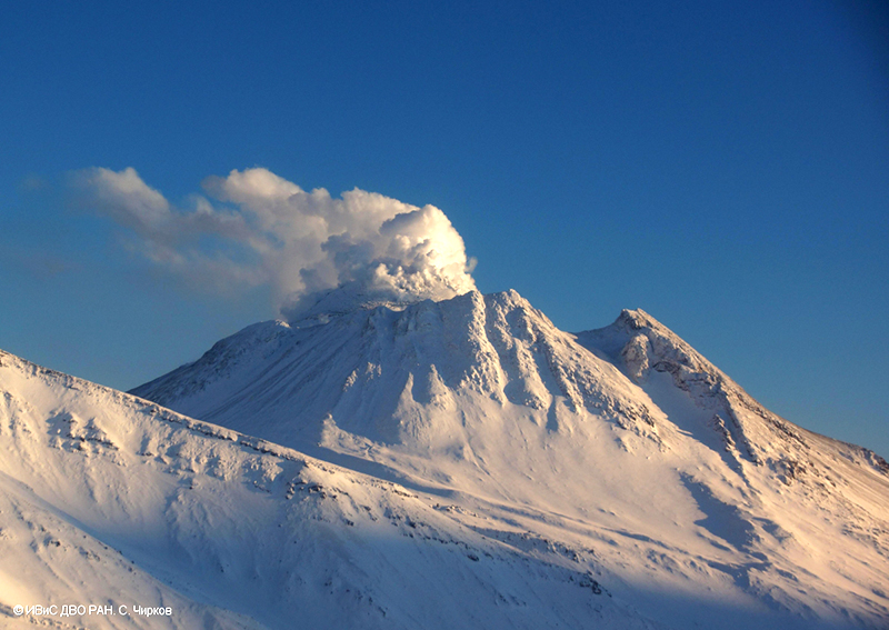 |
Figure 41. Photo of Bezymianny showing strong fumarolic activity on 8 December 2020. Photo by S. Chirkov, IVS FEB RAS. Courtesy of IVS FEB RAS, KVERT. |
The MIROVA (Middle InfraRed Observation of Volcanic Activity) volcano hotspot detection system based on the analysis of MODIS data showed relatively strong and frequent thermal anomalies during early November to early December due to the continuing lava dome growth, followed by variable, intermittent thermal activity into mid-January 2021. About four low-power anomalies were detected in mid-February (figure 42). This thermal activity was also reflected in Sentinel-2 thermal satellite imagery; thermal anomalies were observed in the summit crater over the lava dome, occasionally accompanied by white gas-and-steam emissions (figure 43).
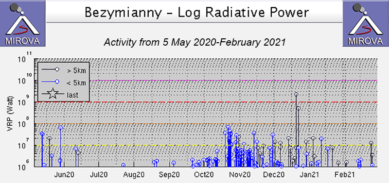 |
Figure 42. Relatively strong and frequent thermal anomalies at Bezymianny were recorded by the MIROVA system (Log Radiative Power) during November through early December 2020, due to the growing lava dome. Thermal activity continued at intermittent intervals through mid-February 2021. Four low-power thermal anomalies were detected in February. Courtesy of MIROVA. |
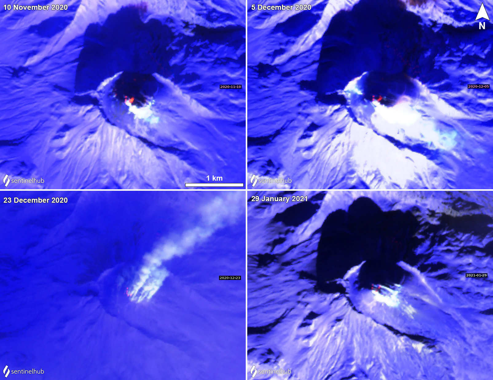 |
Figure 43. Sentinel-2 thermal satellite images showing a thermal anomaly (dark orange) over the lava dome at Bezymianny’s summit crater on 10 November (top left), 5 December (top right), 23 December 2020 (bottom left), and 29 January 2021 (bottom right). The thermal anomaly is frequently accompanied by strong gas-and-steam emissions, as shown in each of these images. Sentinel-2 satellite images with “Atmospheric penetration” (bands 12, 11, 8A) rendering. Courtesy of Sentinel Hub Playground. |
Information Contacts: Kamchatka Volcanic Eruptions Response Team (KVERT), Far Eastern Branch, Russian Academy of Sciences, 9 Piip Blvd., Petropavlovsk-Kamchatsky, 683006, Russia (URL: http://www.kscnet.ru/ivs/kvert/); MIROVA (Middle InfraRed Observation of Volcanic Activity), a collaborative project between the Universities of Turin and Florence (Italy) supported by the Centre for Volcanic Risk of the Italian Civil Protection Department (URL: http://www.mirovaweb.it/); Sentinel Hub Playground (URL: https://www.sentinel-hub.com/explore/sentinel-playground).
Frequent gas-and-steam emissions and a weak thermal anomaly during March-August 2021
Bezymianny, part of the Klyuchevskoy volcano group on the Kamchatka Peninsula, has had frequent eruptions dating back to 1955. The current eruptive period began in May 2010 and has recently consisted of lava dome growth, strong fumarolic activity, and thermal anomalies (BGVN 46:03). This report covers similar low activity of white gas-and-steam emissions and a persistent, weak thermal anomaly at the summit crater during March through August 2021 using weekly and daily reports from the Kamchatka Volcano Eruptions Response Team (KVERT) and satellite data.
Activity at Bezymianny was relatively low during the reporting period, mostly consisting of frequent moderate gas-and-steam emissions (figure 44) and a weak thermal anomaly over the lava dome in the summit crater. The MIROVA (Middle InfraRed Observation of Volcanic Activity) volcano hotspot detection system based on the analysis of MODIS data showed intermittent low-power thermal anomalies during late March through August (figure 45). These low-power anomalies were also detected in the summit crater, occasionally accompanied by white gas-and-steam emissions on clear weather days, based on Sentinel-2 infrared satellite images (figure 46).
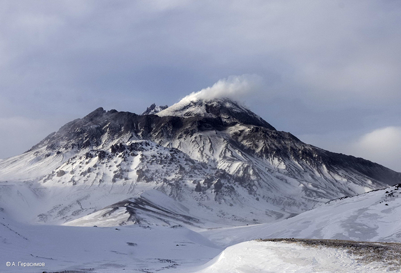 |
Figure 44. Photo of Bezymianny showing strong fumarolic activity on 30 March 2021. Photo by A. Gerasimov, IVS FEB RAS. Courtesy of IVS FEB RAS, KVERT. |
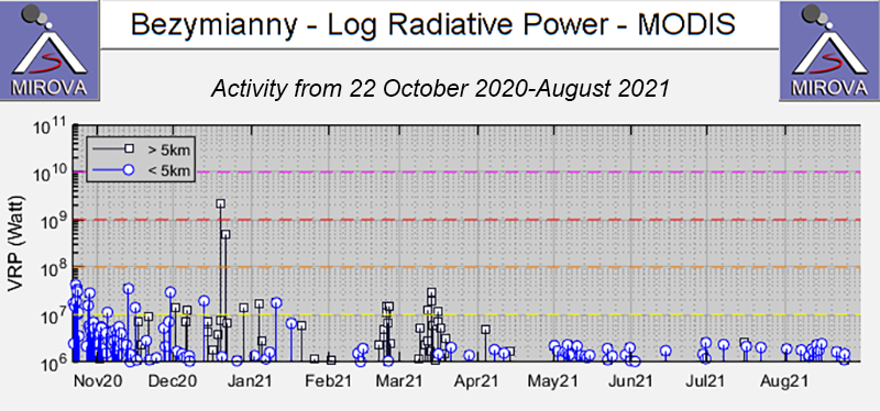 |
Figure 45. Intermittent low-power thermal anomalies at Bezymianny were detected by the MIROVA system (Log Radiative Power) during late March through August 2021. Courtesy of MIROVA. |
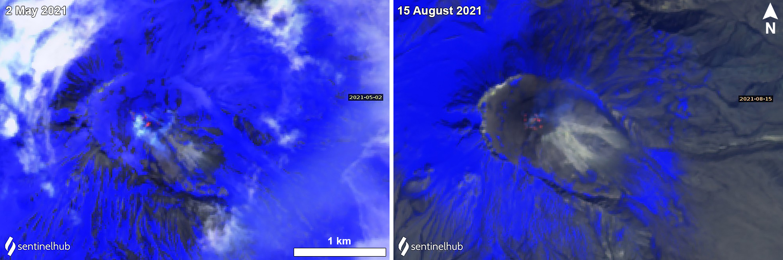 |
Figure 46. Sentinel-2 infrared satellite images of a weak thermal anomaly (dark orange) over the lava dome at Bezymianny’s summit crater on 2 May (left) and 15 August (right) 2021. The thermal anomaly is occasionally accompanied by white gas-and-steam emissions. Sentinel-2 satellite images with “Atmospheric penetration” (bands 12, 11, 8A) rendering. Courtesy of Sentinel Hub Playground. |
Information Contacts: Kamchatka Volcanic Eruptions Response Team (KVERT), Far Eastern Branch, Russian Academy of Sciences, 9 Piip Blvd., Petropavlovsk-Kamchatsky, 683006, Russia (URL: http://www.kscnet.ru/ivs/kvert/); MIROVA (Middle InfraRed Observation of Volcanic Activity), a collaborative project between the Universities of Turin and Florence (Italy) supported by the Centre for Volcanic Risk of the Italian Civil Protection Department (URL: http://www.mirovaweb.it/); Sentinel Hub Playground (URL: https://www.sentinel-hub.com/explore/sentinel-playground).
Strong explosion with ash plumes, pyroclastic flows, and incandescence during 15-16 March 2022
Bezymianny is located on the Kamchatka Peninsula as part of the Klyuchevskoy volcano group. Historical eruptions dating back to 1955 were characterized by dome growth, explosions, pyroclastic flows, ash plumes, and ashfall. The current eruption period began in May 2010, with recent activity consisting of frequent gas-and-steam emissions and weak thermal anomalies at the summit crater (BGVN 46:09). This report covers a strong explosion during 15-16 March 2022, which included ash plumes, block-and-ash avalanches, pyroclastic flows, and dome incandescence. In addition, similar low activity of gas-and-steam emissions and a frequent weak thermal anomaly at the summit crater occurred during September 2021 through April 2022 based on weekly and daily reports from the Kamchatka Volcano Eruptions Response Team (KVERT) and satellite data.
Activity during this reporting period prior to 15 March 2022 was relatively low, and according to KVERT, primarily consisted of persistent gas-and-steam emissions and weak thermal anomalies in the summit from the growing lava dome, though they were often obscured by clouds. The MIROVA (Middle InfraRed Observation of Volcanic Activity) volcano hotspot detection system based on the analysis of MODIS data showed intermittent low-power thermal anomalies during mid-September through March 2022 (figure 47). Some of these weak anomalies were visible in infrared satellite imagery on clear weather days; on 19 September the anomalies were accompanied by a gas-and-steam plume that drifted NE (figure 48). Two anomalies were observed during late October and three during mid-December. A brief spike in activity was recorded in mid-March in MIROVA data and the frequency and strength of the anomalies remained higher than the previous months through April.
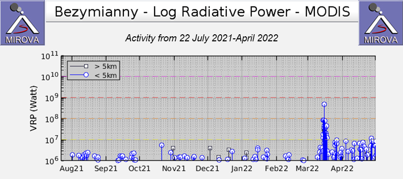 |
Figure 47. Low-strength thermal anomalies were detected during September 2021 through March 2022 at Bezymianny, according to this MIROVA graph (Log Radiative Power). Only two anomalies were observed during late October and three during mid-December. A large spike in thermal activity was briefly recorded during mid-March and the frequency remained higher than the previous months through April. Courtesy of MIROVA. |
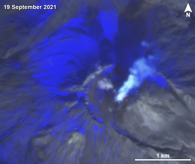 |
Figure 48. Sentinel-2 infrared satellite image showing a weak thermal anomaly at the summit crater of Bezymianny on 19 September 2021. A gas-and-steam plume was also captured drifting NE. Image with “Atmospheric penetration” (bands 12, 11, 8A) rendering. Courtesy of Sentinel Hub Playground. |
During March 2022, activity increased slightly. On 15 March an ash plume was visible in satellite images at 0310 that rose to 4.9 km altitude and drifted 90 km W, indicating renewed explosive activity. By 0600 ash plumes rose to 6.1 km altitude and drifted S. Ash continued to be reported throughout the day; at 1322 they rose to 8.2 km and drifted SW. Satellite images showed block-and-ash flows descending the SE flank to the base, generating dark brown ash plumes. Thermal anomalies were visible at the summit and at the end of the flow. As a result, KVERT raised the Aviation Color Code (ACC) to Orange (the second highest level on a four-color scale). Activity intensified at 0053 on 16 March; ash plumes rose to roughly 12 km altitude and drifted more than 1,300 km NW and then NE. Activity during this time was also characterized by pyroclastic flows that descended the S, W, and N flanks. A large thermal anomaly was visible through 18 March, indicating continuing lava dome growth. On 23 March the ACC was lowered to Yellow. Dome collapses were detected on 25 and 31 March and ash clouds rose to 4 km altitude that drifted 40 km E and 20 km SW, respectively. Strong fumarolic activity, an incandescent lava dome, and avalanches were reported daily through April.
Information Contacts: Kamchatka Volcanic Eruptions Response Team (KVERT), Far Eastern Branch, Russian Academy of Sciences, 9 Piip Blvd., Petropavlovsk-Kamchatsky, 683006, Russia (URL: http://www.kscnet.ru/ivs/kvert/); Tokyo Volcanic Ash Advisory Center (VAAC), 1-3-4 Otemachi, Chiyoda-ku, Tokyo 100-8122, Japan (URL: http://ds.data.jma.go.jp/svd/vaac/data/); MIROVA (Middle InfraRed Observation of Volcanic Activity), a collaborative project between the Universities of Turin and Florence (Italy) supported by the Centre for Volcanic Risk of the Italian Civil Protection Department (URL: http://www.mirovaweb.it/); Sentinel Hub Playground (URL: https://www.sentinel-hub.com/explore/sentinel-playground).
Strong explosions in late May and late October 2022, accompanied by ash plumes and thermal activity
Bezymianny, located on the Kamchatka Peninsula of Russia as part of the Klyuchevskoy volcano group, has had eruptions that date back to 1955 characterized by dome growth, explosions, pyroclastic flows, ash plumes, and ashfall. During the 1955-56 eruption a large open crater was formed by collapse of the summit and an associated lateral blast. Subsequent episodic but ongoing lava-dome growth, accompanied by intermittent explosive activity and pyroclastic flows, has largely filled the 1956 crater. The current eruption period began in December 2016 and more recent activity has consisted of a strong explosion with ash plumes during mid-March 2022. Gas-and-steam emissions and frequent thermal anomalies at the summit crater were also reported. This report updates information during May through October 2022 of similar activity, based on weekly and daily reports from the Kamchatka Volcano Eruptions Response Team (KVERT), Tokyo VAAC (Volcanic Ash Advisory Center), and satellite data.
Activity during May was relatively strong, with explosions, strong fumarolic activity, hot avalanches, and frequent thermal anomalies at the lava dome that were detected in satellite imagery. On 24 May gas-and-steam plumes containing some amount of ash rose to 3-4.5 km altitude and drifted 30 km NW. Similar activity occurred on 25 May when plumes drifted 25 km NE and 30 km W. During 23-28 May seismicity increased, according to KVERT. Multiple notable collapses of hot avalanches on the E flank produced ash plumes that rose to 4-5 km altitude and drifted 70-320 km in different directions.
Activity significantly increased on 28 May. According to Kamchatka Volcanological Station (Volkstat), observers saw ash plumes beginning to rise around lunchtime, with the plumes gradually increasing in altitude throughout the day. During the late evening a large, strong, explosive event occurred; ash plumes rose to 11 km altitude and drifted E. According to KVERT satellite data showed ash plumes rising to 10-12 km altitude and drifting ESE at 1920. As a result, the Aviation Color Code (ACC) was raised to Red (the highest level on a four-color scale). By 2010 the ash plumes had risen to 15 km altitude and previous ash emissions had drifted 365 km SE. Volkstat observers noted that activity began to decline by about 2020; plumes did not exceed 6 km altitude and drifted SE. At 2207 KVERT issued a VONA (Volcano Observatory Notice for Aviation) that reported that the ACC was lowered to Orange because the most intense phase of the explosive eruption had ended. Ash plumes continued to rise no higher than 5 km, based on webcam images. Two ash plumes were identified in satellite images; the first drifted 212 km SE at an altitude of 9.5 km altitude and the second drifted 650 km SE, though the altitude was unspecified. On 29 May at 1000 gas-and-steam plumes containing some ash, visible in webcam images, rose as high as 4.5 km altitude and drifted 45 km SE. Satellite images showed that the large ash plume from 28 May had drifted 1,635-3,500 km SE throughout the day. In Washington and Tokyo VAAC notices on 30 May a remnant ash plume had risen to 4.9-15.2 km altitude and was visible in satellite imagery over the north Pacific.
During June and July strong fumarolic activity persisted, a thermal anomaly was often detected in satellite imagery through the early part of July, and lava dome incandescence and hot avalanches were frequently reported (figure 49). On 3 July the Tokyo VAAC reported a possible ash plume rose to 6.4 km altitude and extended SE, though meteoric clouds obscured views of the summit. Similar low activity continued during August; strong fumarolic activity continued with lava dome incandescence and hot avalanches. A thermal anomaly was frequently reported throughout the month. The Tokyo VAAC reported that on 22 August an ash plume was identified in satellite imagery rose to 3.7 km altitude and drifted NE.
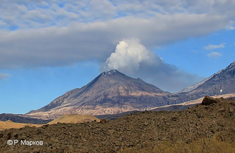 |
Figure 49. Photo of a strong white gas-and-steam plume rising above Bezymianny on 7 June 2022. An active lava flow was reported at the lava dome on the E flank. Courtesy of R. Markov, KVERT. |
Low activity continued through September and during much of October, which typically consisted of a thermal anomaly on clear weather days and gas-and-steam emissions. Activity increased during 22-23 October and was characterized by summit crater incandescence, occasional strong fumarolic activity, and an increasing temperature of a thermal anomaly that was detected in satellite images. A strong explosive event began on 23 October at 2340, with satellite images showing ash plumes rising to 10 km altitude and drifting 10 km ENE (figure 50). By the next day the ash plumes had drifted as far as 1,915 km NE. On 26 October avalanches generated an ash cloud that rose to 6 km and drifted 70 km E.
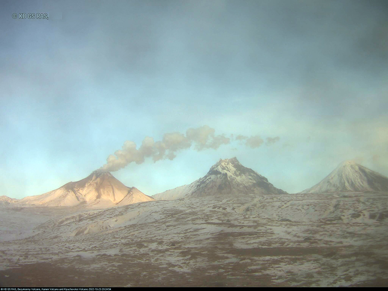 |
Figure 50. Webcam image of a gray ash plume rising from Bezymianny on 23 October 2022 and drifting ENE due to a strong explosion. Photo has been color corrected. Courtesy of Yu Demyanchuk, KVERT. |
Strong thermal activity occurred frequently during May, June, and October, based on satellite data. A total of 11 thermal hotspots were detected by the MODVOLC thermal algorithm on 15, 20, 23, 25, and 30 May, 2 June, and 23 October. These days of stronger thermal activity were also reflected in other satellite data sources and occurred around days when a strong explosive event took place, according to KVERT. The MIROVA (Middle InfraRed Observation of Volcanic Activity) volcano hotspot detection system based on the analysis of MODIS data showed a gradual increase in both frequency and power during May, which both peaked during late May (figure 51). During June through mid-July the anomalies gradually decreased in both frequency and power. By August only three anomalies were detected by the MIROVA system, and in September four anomalies were detected. During late October, there was another increase in power and frequency, followed by several lower-power anomalies. Sentinel-2 infrared satellite imagery captured incandescence at the summit crater on clear weather days during these periods of stronger thermal activity (figure 52). On 24 May an incandescent avalanche was also visible on the SE flank. On 3 June a second thermal anomaly was detected on the SE flank as well. On 24 October several small thermal anomalies were visible in the summit crater and on the S flank.
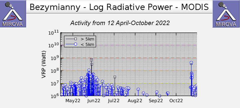 |
Figure 51. Frequent moderate-power thermal anomalies were detected at Bezymianny during May through late July 2022 and toward the end of October, according to this MIROVA graph (Log Radiative Power). During early through mid-May the thermal anomalies were gradually increasing in power, which then peaked in late May and gradually declined again afterward. The anomalies decreased in both power and frequency through July. By August, only three low-power anomalies were detected, and four more anomalies were detected in September. The frequency and power increased again in late October. Courtesy of MIROVA. |
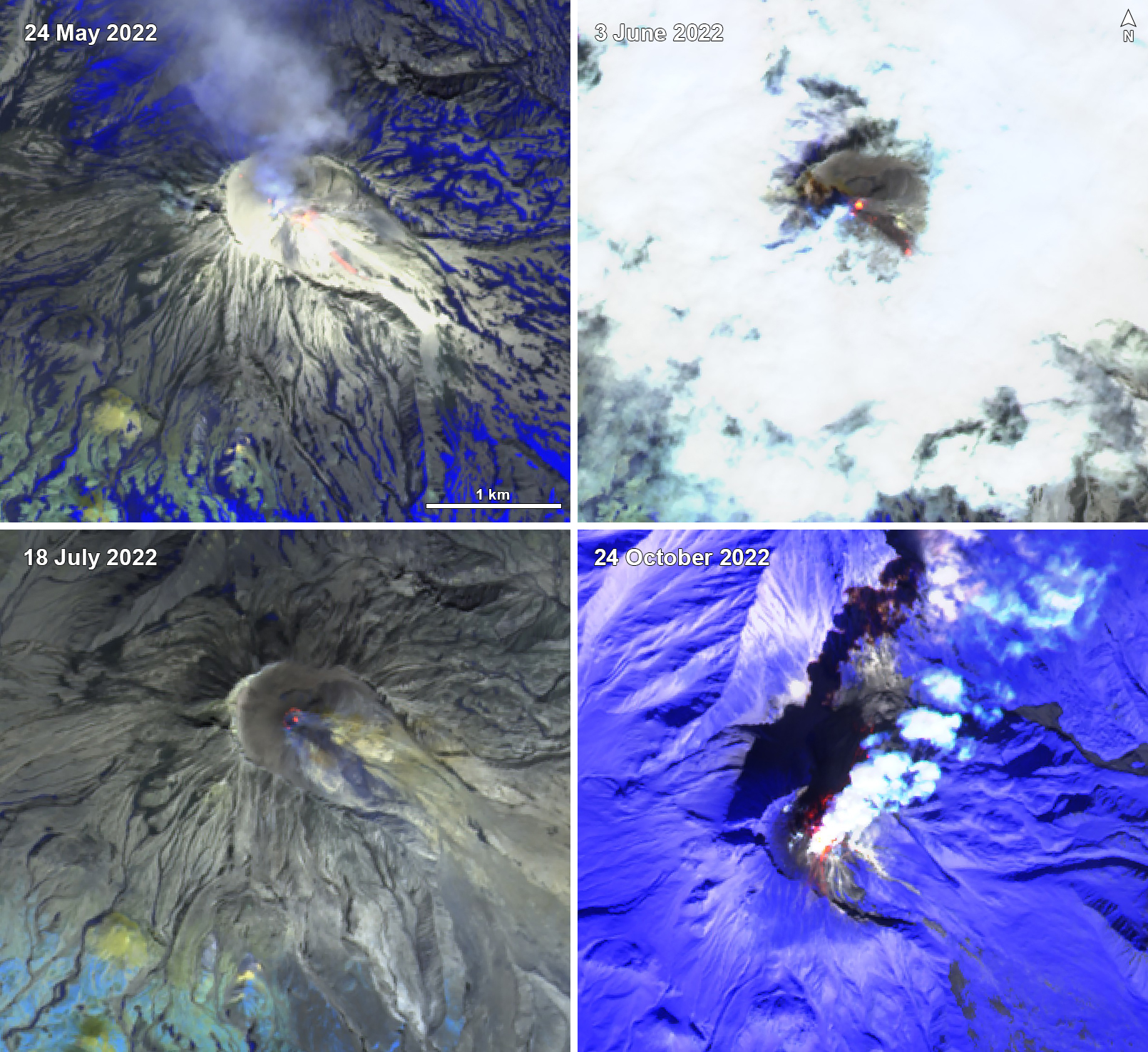 |
Figure 52. Sentinel-2 infrared satellite images of Bezymianny showing days with a relatively strong thermal anomaly at the summit crater on 24 May 2022 (top left), 3 June 2022 (top right), 18 July 2022 (bottom left), and 24 October 2022 (bottom right). Gas-and-steam emissions often accompanied the activity, as shown on 24 May, and 24 October. On 24 May an incandescent avalanche was also visible on the SE flank. On 3 June a second thermal anomaly was visible on the SE flank. On 24 October multiple small thermal anomalies were detected in the summit crater and on the S flank. Images with “Atmospheric penetration” (bands 12, 11, 8A) rendering. Courtesy of Sentinel Hub Playground. |
Information Contacts: Kamchatka Volcanic Eruptions Response Team (KVERT), Far Eastern Branch, Russian Academy of Sciences, 9 Piip Blvd., Petropavlovsk-Kamchatsky, 683006, Russia (URL: http://www.kscnet.ru/ivs/kvert/); Kamchatka Volcanological Station, Kamchatka Branch of Geophysical Survey, (KB GS RAS), Klyuchi, Kamchatka Krai, Russia (URL: http://volkstat.ru/); Tokyo Volcanic Ash Advisory Center (VAAC), 1-3-4 Otemachi, Chiyoda-ku, Tokyo 100-8122, Japan (URL: http://ds.data.jma.go.jp/svd/vaac/data/); Washington Volcanic Ash Advisory Center (VAAC), Satellite Analysis Branch (SAB), NOAA/NESDIS OSPO, NOAA Science Center Room 401, 5200 Auth Rd, Camp Springs, MD 20746, USA (URL: www.ospo.noaa.gov/Products/atmosphere/vaac, archive at: http://www.ssd.noaa.gov/VAAC/archive.html); MIROVA (Middle InfraRed Observation of Volcanic Activity), a collaborative project between the Universities of Turin and Florence (Italy) supported by the Centre for Volcanic Risk of the Italian Civil Protection Department (URL: http://www.mirovaweb.it/); Hawai'i Institute of Geophysics and Planetology (HIGP) - MODVOLC Thermal Alerts System, School of Ocean and Earth Science and Technology (SOEST), Univ. of Hawai'i, 2525 Correa Road, Honolulu, HI 96822, USA (URL: http://modis.higp.hawaii.edu/); Sentinel Hub Playground (URL: https://www.sentinel-hub.com/explore/sentinel-playground).
Explosions, ash plumes, lava flows, and avalanches during November 2022-April 2023
Bezymianny is located on the Kamchatka Peninsula of Russia as part of the Klyuchevskoy volcano group. Historic eruptions began in 1955 and have been characterized by dome growth, explosions, pyroclastic flows, ash plumes, and ashfall. During the 1955-56 eruption a large open crater was formed by collapse of the summit and an associated lateral blast. Subsequent episodic but ongoing lava-dome growth, accompanied by intermittent explosive activity and pyroclastic flows, has largely filled the 1956 crater. The current eruption period began in December 2016 and more recent activity has consisted of strong explosions, ash plumes, and thermal activity (BGVN 47:11). This report covers activity during November 2022 through April 2023, based on weekly and daily reports from the Kamchatka Volcano Eruptions Response Team (KVERT) and satellite data.
Activity during November and March 2023 was relatively low and mostly consisted of gas-and-steam emissions, occasional small collapses that generated avalanches along the lava dome slopes, and a persistent thermal anomaly over the volcano that was observed in satellite data on clear weather days. According to the Tokyo VAAC and KVERT, an explosion produced an ash plume that rose to 6 km altitude and drifted 25 km NE at 1825 on 29 March.
Gas-and-steam emissions, collapses generating avalanches, and thermal activity continued during April. According to two Volcano Observatory Notice for Aviation (VONA) issued on 2 and 6 April (local time) ash plumes rose to 3 km and 3.5-3.8 km altitude and drifted 35 km E and 140 km E, respectively. Satellite data from KVERT showed weak ash plumes extending up to 550 km E on 2 and 5-6 April.
A VONA issued at 0843 on 7 April described an ash plume that rose to 4.5-5 km altitude and drifted 250 km ESE. Later that day at 1326 satellite data showed an ash plume that rose to 5.5-6 km altitude and drifted 150 km ESE. A satellite image from 1600 showed an ash plume extending as far as 230 km ESE; KVERT noted that ash emissions were intensifying, likely due to avalanches from the growing lava dome. The Aviation Color Code (ACC) was raised to Red (the highest level on a four-color scale). At 1520 satellite data showed an ash plume rising to 5-5.5 km altitude and drifting 230 km ESE. That same day, Kamchatka Volcanological Station (KVS) volcanologists traveled to Ambon to collect ash; they reported that a notable eruption began at 1730, and within 20 minutes a large ash plume rose to 10 km altitude and drifted NW. KVERT reported that the strong explosive phase began at 1738. Video and satellite data taken at 1738 showed an ash plume that rose to 10-12 km altitude and drifted up to 2,800 km SE and E. Explosions were clearly audible 20 km away for 90 minutes, according to KVS. Significant amounts of ash fell at the Apakhonchich station, which turned the snow gray; ash continued to fall until the morning of 8 April. In a VONA issued at 0906 on 8 April, KVERT stated that the explosive eruption had ended; ash plumes had drifted 2,000 km E. The ACC was lowered to Orange (the third highest level on a four-color scale). The KVS team saw a lava flow on the active dome once the conditions were clear that same day (figure 53). On 20 April lava dome extrusion was reported; lava flows were noted on the flanks of the dome, and according to KVERT satellite data, a thermal anomaly was observed in the area. The ACC was lowered to Yellow (the second lowest on a four-color scale).
 |
Figure 53. Photo showing an active lava flow descending the SE flank of Bezymianny from the lava dome on 8 April 2023. Courtesy of Yu. Demyanchuk, IVS FEB RAS, KVERT. |
Satellite data showed an increase in thermal activity beginning in early April 2023. A total of 31 thermal hotspots were detected by the MODVOLC thermal algorithm on 4, 5, 7, and 12 April 2023. The elevated thermal activity resulted from an increase in explosive activity and the start of an active lava flow. The MIROVA (Middle InfraRed Observation of Volcanic Activity) volcano hotspot detection system based on the analysis of MODIS data also showed a pulse in thermal activity during the same time (figure 54). Infrared satellite imagery captured a continuous thermal anomaly at the summit crater, often accompanied by white gas-and-steam emissions (figure 55). On 4 April 2023 an active lava flow was observed descending the SE flank.
 |
Figure 54. Intermittent and low-power thermal anomalies were detected at Bezymianny during December 2022 through mid-March 2023, according to this MIROVA graph (Log Radiative Power). In early April 2023, an increase in explosive activity and eruption of a lava flow resulted in a marked increase in thermal activity. Courtesy of MIROVA. |
 |
Figure 55. Infrared satellite images of Bezymianny showed a persistent thermal anomaly over the lava dome on 18 November 2022 (top left), 28 December 2022 (top right), 15 March 2023 (bottom left), and 4 April 2023 (bottom right), often accompanied by white gas-and-steam plumes. On 4 April a lava flow was active and descending the SE flank. Images using infrared (bands 12, 11, 8a). Courtesy of Copernicus Browser. |
Information Contacts: Kamchatka Volcanic Eruptions Response Team (KVERT), Far Eastern Branch, Russian Academy of Sciences, 9 Piip Blvd., Petropavlovsk-Kamchatsky, 683006, Russia (URL: http://www.kscnet.ru/ivs/kvert/); Kamchatka Volcanological Station, Kamchatka Branch of Geophysical Survey, (KB GS RAS), Klyuchi, Kamchatka Krai, Russia (URL: http://volkstat.ru/); Hawai'i Institute of Geophysics and Planetology (HIGP) - MODVOLC Thermal Alerts System, School of Ocean and Earth Science and Technology (SOEST), Univ. of Hawai'i, 2525 Correa Road, Honolulu, HI 96822, USA (URL: http://modis.higp.hawaii.edu/); MIROVA (Middle InfraRed Observation of Volcanic Activity), a collaborative project between the Universities of Turin and Florence (Italy) supported by the Centre for Volcanic Risk of the Italian Civil Protection Department (URL: http://www.mirovaweb.it/); Copernicus Browser, Copernicus Data Space Ecosystem, European Space Agency (URL: https://dataspace.copernicus.eu/browser/).
Explosion on 18 October 2023 sends ash plume 8 km high; lava flows and incandescent avalanches
Bezymianny, located on Russia’s Kamchatka Peninsula, has had eruptions since 1955 characterized by dome growth, explosions, pyroclastic flows, ash plumes, and ashfall. Activity during November 2022-April 2023 included gas-and-steam emissions, lava dome collapses generating avalanches, and persistent thermal activity. Similar eruptive activity continued from May through October 2023, described here based on information from weekly and daily reports of the Kamchatka Volcano Eruptions Response Team (KVERT), notices from Tokyo VAAC (Volcanic Ash Advisory Center), and from satellite data.
Overall activity decreased after the strong period of activity in late March through April 2023, which included ash explosions during 29 March and 7-8 April 2023 that sent plumes as high as 10-12 km altitude, along with dome growth and lava flows (BGVN 48:05). This reduced activity can be seen in the MIROVA thermal detection system graph (figure 56), which was consistent with data from the MODVOLC thermal detection system and with Sentinel-2 satellite images that showed persistent hotspots in the summit crater when conditions allowed observations. A renewed period of strong activity began in mid-October 2023.
|
Figure 56. The MIROVA (Log Radiative Power) thermal data for Bezymianny during 20 November 2022 through October 2023 shows heightened activity in the first half of April and second half of October 2023, with lower levels of thermal anomalies in between those times. Courtesy of MIROVA. |
Activity increased significantly on 17 October 2023 when large collapses began during 0700-0830 on the E flanks of the lava dome and continued to after 0930 the next day (figure 57). Ash plumes rose to an altitude of 4.5-5 km, extending 220 km NNE by 18 October. A large explosion at 1630 on 18 October produced an ash plume that rose to an altitude of 11 km (8 km above the summit) and drifted NNE and then NW, extending 900 km NW within two days at an altitude of 8 km. Minor ashfall was noted in Kozyrevsk (45 km WNW). At 0820 on 20 October an ash plume was identified in satellite images drifting 100 km ENE at altitudes of 4-4.5 km.
|
Figure 57. Sentinel-2 satellite images of Bezymianny from 1159 on 17 October 2023 (2359 on 16 October UTC) showing a snow-free S and SE flank along with thermal anomalies in the crater and down the SE flank. Left image is in false color (bands 8, 4, 3); right image is thermal infrared (bands 12, 11, 8A). Courtesy of Copernicus Browser. |
Lava flows and hot avalanches from the dome down the SE flank continued over the next few days, including 23 October when clear conditions allowed good observations (figures 58 and 59). A large thermal anomaly was observed over the volcano through 24 October, and in the summit crater on 30 October (figure 60). Strong fumarolic activity continued, with numerous avalanches and occasional incandescence. By the last week of October, volcanic activity had decreased to a level consistent with that earlier in the reporting period.
|
Figure 58. Daytime photo of Bezymianny under clear conditions on 23 October 2023 showing a lava flow and avalanches descending the SE flank, incandescence from the summit crater, and a small ash plume. Photo by Yu. Demyanchuk, courtesy of IVS FEB RAS, KVERT. |
|
Figure 59. Night photo of Bezymianny under cloudy conditions on 23 October 2023 showing an incandescent lava flow and avalanches descending the SE flank. Photo by Yu. Demyanchuk, courtesy of IVS FEB RAS, KVERT. |
|
Figure 60. Sentinel-2 satellite images of Bezymianny from 1159 on 30 October 2023 (2359 on 29 October UTC) showing a plume drifting SE and thermal anomalies in the summit crater and down multiple flanks. Left image is in true color (bands 4, 3, 2); right image is thermal infrared (bands 12, 11, 8A). Courtesy of Copernicus Browser. |
Aviation warnings were frequently updated during 17-20 October. KVERT issued a Volcano Observatory Notice for Aviation (VONA) on 17 October at 1419 and 1727 (0219 and 0527 UTC) raising the Aviation Color Code (ACC) from Yellow to Orange (second highest level). The next day, KVERT issued a VONA at 1705 (0505 UTC) raising the ACC to Red (highest level) but lowered it back to Orange at 2117 (0917 UTC). After another decrease to Yellow and back to Orange, the ACC was reduced to Yellow on 20 October at 1204 (0004 UTC). In addition, the Tokyo VAAC issued a series of Volcanic Ash Advisories beginning on 16 October and continuing through 30 October.
Information Contacts: Kamchatka Volcanic Eruptions Response Team (KVERT), Far Eastern Branch, Russian Academy of Sciences, 9 Piip Blvd., Petropavlovsk-Kamchatsky, 683006, Russia (URL: http://www.kscnet.ru/ivs/kvert/); Kamchatka Volcanological Station, Kamchatka Branch of Geophysical Survey, (KB GS RAS), Klyuchi, Kamchatka Krai, Russia (URL: http://volkstat.ru/); Tokyo Volcanic Ash Advisory Center (VAAC), 1-3-4 Otemachi, Chiyoda-ku, Tokyo 100-8122, Japan (URL: http://ds.data.jma.go.jp/svd/vaac/data/); Hawai'i Institute of Geophysics and Planetology (HIGP) - MODVOLC Thermal Alerts System, School of Ocean and Earth Science and Technology (SOEST), Univ. of Hawai'i, 2525 Correa Road, Honolulu, HI 96822, USA (URL: http://modis.higp.hawaii.edu/); MIROVA (Middle InfraRed Observation of Volcanic Activity), a collaborative project between the Universities of Turin and Florence (Italy) supported by the Centre for Volcanic Risk of the Italian Civil Protection Department (URL: http://www.mirovaweb.it/); Copernicus Browser, Copernicus Data Space Ecosystem, European Space Agency (URL: https://dataspace.copernicus.eu/browser/).chr
|
|
||||||||||||||||||||||||||
There is data available for 69 confirmed eruptive periods.
2024 Dec 24 - 2025 Sep 19 (continuing) Confirmed Eruption (Explosive / Effusive)
| Episode 1 | Eruption (Explosive / Effusive) | ||||
|---|---|---|---|---|
| 2024 Dec 24 - 2025 Sep 19 (continuing) | Evidence from Observations: Satellite (infrared) | |||
2022 Mar 15 - 2024 Aug 14 ± 2 days Confirmed Eruption (Explosive / Effusive) VEI: 3
| Episode 1 | Eruption (Explosive / Effusive) | Summit crater | |||||||||||||||||||||||||||||||||||||||||||||||||||||
|---|---|---|---|---|---|---|---|---|---|---|---|---|---|---|---|---|---|---|---|---|---|---|---|---|---|---|---|---|---|---|---|---|---|---|---|---|---|---|---|---|---|---|---|---|---|---|---|---|---|---|---|---|---|---|
| 2022 Mar 15 - 2024 Aug 14 ± 2 days | Evidence from Observations: Reported | |||||||||||||||||||||||||||||||||||||||||||||||||||||
|
List of 9 Events for Episode 1 at Summit crater
|
||||||||||||||||||||||||||||||||||||||||||||||||||||||
2016 Dec 5 - 2021 Feb 1 ± 15 days Confirmed Eruption (Explosive / Effusive) VEI: 3
| Episode 1 | Eruption (Explosive / Effusive) | Summit crater | |||||||||||||||||||||||||||||||||||||||||||||||||||||||||||||||||||||||||||||||||||||||||||||||||||||||
|---|---|---|---|---|---|---|---|---|---|---|---|---|---|---|---|---|---|---|---|---|---|---|---|---|---|---|---|---|---|---|---|---|---|---|---|---|---|---|---|---|---|---|---|---|---|---|---|---|---|---|---|---|---|---|---|---|---|---|---|---|---|---|---|---|---|---|---|---|---|---|---|---|---|---|---|---|---|---|---|---|---|---|---|---|---|---|---|---|---|---|---|---|---|---|---|---|---|---|---|---|---|---|---|---|
| 2016 Dec 5 - 2017 Apr 21 | Evidence from Observations: Reported | |||||||||||||||||||||||||||||||||||||||||||||||||||||||||||||||||||||||||||||||||||||||||||||||||||||||
|
List of 19 Events for Episode 1 at Summit crater
|
||||||||||||||||||||||||||||||||||||||||||||||||||||||||||||||||||||||||||||||||||||||||||||||||||||||||
| Episode 2 | Eruption (Explosive / Effusive) | Summit crater | |||||||||||||||||||||||||||||||||||||||||||||||||||||||||||||||||||||||||||||||||||||||||||||||||||||||||||||||||||||||||||||||||||||||||||||||
|---|---|---|---|---|---|---|---|---|---|---|---|---|---|---|---|---|---|---|---|---|---|---|---|---|---|---|---|---|---|---|---|---|---|---|---|---|---|---|---|---|---|---|---|---|---|---|---|---|---|---|---|---|---|---|---|---|---|---|---|---|---|---|---|---|---|---|---|---|---|---|---|---|---|---|---|---|---|---|---|---|---|---|---|---|---|---|---|---|---|---|---|---|---|---|---|---|---|---|---|---|---|---|---|---|---|---|---|---|---|---|---|---|---|---|---|---|---|---|---|---|---|---|---|---|---|---|---|---|---|---|---|---|---|---|---|---|---|---|---|---|---|---|---|---|
| 2017 Jun 9 - 2017 Oct 5 | Evidence from Observations: Reported | |||||||||||||||||||||||||||||||||||||||||||||||||||||||||||||||||||||||||||||||||||||||||||||||||||||||||||||||||||||||||||||||||||||||||||||||
|
List of 27 Events for Episode 2 at Summit crater
|
||||||||||||||||||||||||||||||||||||||||||||||||||||||||||||||||||||||||||||||||||||||||||||||||||||||||||||||||||||||||||||||||||||||||||||||||
| Episode 3 | Eruption (Explosive / Effusive) | Summit crater | ||||||||||||||||||||||||||||||||||||||||||||||||||||||||||||||||||||||||||||||||||||||||||||||||||||||||||||||||||||||||||||||||||||||||||||||||||||||||||||||||||||||||||||||||||||||||||||||||||||||||||||||||||||||||||||||||||||||||||||||||||||||||||||||||||||||||||||||||||||||||||||||||||||||||||
|---|---|---|---|---|---|---|---|---|---|---|---|---|---|---|---|---|---|---|---|---|---|---|---|---|---|---|---|---|---|---|---|---|---|---|---|---|---|---|---|---|---|---|---|---|---|---|---|---|---|---|---|---|---|---|---|---|---|---|---|---|---|---|---|---|---|---|---|---|---|---|---|---|---|---|---|---|---|---|---|---|---|---|---|---|---|---|---|---|---|---|---|---|---|---|---|---|---|---|---|---|---|---|---|---|---|---|---|---|---|---|---|---|---|---|---|---|---|---|---|---|---|---|---|---|---|---|---|---|---|---|---|---|---|---|---|---|---|---|---|---|---|---|---|---|---|---|---|---|---|---|---|---|---|---|---|---|---|---|---|---|---|---|---|---|---|---|---|---|---|---|---|---|---|---|---|---|---|---|---|---|---|---|---|---|---|---|---|---|---|---|---|---|---|---|---|---|---|---|---|---|---|---|---|---|---|---|---|---|---|---|---|---|---|---|---|---|---|---|---|---|---|---|---|---|---|---|---|---|---|---|---|---|---|---|---|---|---|---|---|---|---|---|---|---|---|---|---|---|---|---|---|---|---|---|---|---|---|---|---|---|---|---|---|---|---|---|---|---|---|---|---|---|---|---|---|---|---|---|---|---|---|---|---|---|---|---|---|---|---|---|---|---|---|---|---|---|---|---|---|
| 2017 Dec 18 - 2018 Nov 15 ± 15 days | Evidence from Observations: Reported | ||||||||||||||||||||||||||||||||||||||||||||||||||||||||||||||||||||||||||||||||||||||||||||||||||||||||||||||||||||||||||||||||||||||||||||||||||||||||||||||||||||||||||||||||||||||||||||||||||||||||||||||||||||||||||||||||||||||||||||||||||||||||||||||||||||||||||||||||||||||||||||||||||||||||||
|
List of 58 Events for Episode 3 at Summit crater
|
|||||||||||||||||||||||||||||||||||||||||||||||||||||||||||||||||||||||||||||||||||||||||||||||||||||||||||||||||||||||||||||||||||||||||||||||||||||||||||||||||||||||||||||||||||||||||||||||||||||||||||||||||||||||||||||||||||||||||||||||||||||||||||||||||||||||||||||||||||||||||||||||||||||||||||
| Episode 4 | Eruption (Explosive / Effusive) | Summit crater | |||||||||||||||||||||||||||||||||||||||||||||||||||||||||||||||||||||||||||||||||||||||||||||||||||||||||||||||||||||||||||
|---|---|---|---|---|---|---|---|---|---|---|---|---|---|---|---|---|---|---|---|---|---|---|---|---|---|---|---|---|---|---|---|---|---|---|---|---|---|---|---|---|---|---|---|---|---|---|---|---|---|---|---|---|---|---|---|---|---|---|---|---|---|---|---|---|---|---|---|---|---|---|---|---|---|---|---|---|---|---|---|---|---|---|---|---|---|---|---|---|---|---|---|---|---|---|---|---|---|---|---|---|---|---|---|---|---|---|---|---|---|---|---|---|---|---|---|---|---|---|---|---|---|---|---|---|
| 2019 Jan 15 - 2019 Nov 15 ± 15 days | Evidence from Observations: Reported | |||||||||||||||||||||||||||||||||||||||||||||||||||||||||||||||||||||||||||||||||||||||||||||||||||||||||||||||||||||||||||
|
List of 23 Events for Episode 4 at Summit crater
|
||||||||||||||||||||||||||||||||||||||||||||||||||||||||||||||||||||||||||||||||||||||||||||||||||||||||||||||||||||||||||||
| Episode 5 | Eruption (Explosive / Effusive) | Summit crater | ||||||||||||||||||||||||||||||||||||||
|---|---|---|---|---|---|---|---|---|---|---|---|---|---|---|---|---|---|---|---|---|---|---|---|---|---|---|---|---|---|---|---|---|---|---|---|---|---|---|---|
| 2019 Dec 5 - 2020 Jul 1 ± 15 days | Evidence from Observations: Reported | ||||||||||||||||||||||||||||||||||||||
|
List of 6 Events for Episode 5 at Summit crater
|
|||||||||||||||||||||||||||||||||||||||
| Episode 6 | Eruption (Explosive / Effusive) | Summit crater | ||||||||||||||||||||||||||||||||||||||||||||||||||||||||||||||||||||
|---|---|---|---|---|---|---|---|---|---|---|---|---|---|---|---|---|---|---|---|---|---|---|---|---|---|---|---|---|---|---|---|---|---|---|---|---|---|---|---|---|---|---|---|---|---|---|---|---|---|---|---|---|---|---|---|---|---|---|---|---|---|---|---|---|---|---|---|---|---|
| 2020 Aug 26 - 2021 Feb 1 ± 15 days | Evidence from Observations: Satellite (infrared) | ||||||||||||||||||||||||||||||||||||||||||||||||||||||||||||||||||||
|
List of 12 Events for Episode 6 at Summit crater
|
|||||||||||||||||||||||||||||||||||||||||||||||||||||||||||||||||||||
[ 2014 Jun 12 - 2014 Aug 29 ] Uncertain Eruption
| Episode 1 | Uncertain | Summit crater | |||||||||||||||||||||||||||||||||
|---|---|---|---|---|---|---|---|---|---|---|---|---|---|---|---|---|---|---|---|---|---|---|---|---|---|---|---|---|---|---|---|---|---|---|
| 2014 Jun 12 - 2014 Aug 29 | Evidence from Observations: Satellite (infrared) | |||||||||||||||||||||||||||||||||
|
List of 5 Events for Episode 1 at Summit crater
|
||||||||||||||||||||||||||||||||||
2012 Feb 12 - 2013 Jun 20 Confirmed Eruption (Explosive / Effusive) VEI: 3
| Episode 1 | Eruption (Explosive / Effusive) | Summit crater | ||||||||||||||||||||||||||||||||||||||||||||||||||||||||||||||||||||||||||||||||||||||||||||||||||||||||||||
|---|---|---|---|---|---|---|---|---|---|---|---|---|---|---|---|---|---|---|---|---|---|---|---|---|---|---|---|---|---|---|---|---|---|---|---|---|---|---|---|---|---|---|---|---|---|---|---|---|---|---|---|---|---|---|---|---|---|---|---|---|---|---|---|---|---|---|---|---|---|---|---|---|---|---|---|---|---|---|---|---|---|---|---|---|---|---|---|---|---|---|---|---|---|---|---|---|---|---|---|---|---|---|---|---|---|---|---|---|---|
| 2012 Feb 12 - 2012 Jun 7 (on or before) | Evidence from Observations: Reported | ||||||||||||||||||||||||||||||||||||||||||||||||||||||||||||||||||||||||||||||||||||||||||||||||||||||||||||
|
List of 20 Events for Episode 1 at Summit crater
|
|||||||||||||||||||||||||||||||||||||||||||||||||||||||||||||||||||||||||||||||||||||||||||||||||||||||||||||
| Episode 2 | Eruption (Explosive / Effusive) | Summit crater | ||||||||||||||||||||||||||||||||||||||||||||||||||||||||||||||||||||||||||||||||||||||||||||||||||||||||||||||||||||||||||||||||||||||||||||||||||||
|---|---|---|---|---|---|---|---|---|---|---|---|---|---|---|---|---|---|---|---|---|---|---|---|---|---|---|---|---|---|---|---|---|---|---|---|---|---|---|---|---|---|---|---|---|---|---|---|---|---|---|---|---|---|---|---|---|---|---|---|---|---|---|---|---|---|---|---|---|---|---|---|---|---|---|---|---|---|---|---|---|---|---|---|---|---|---|---|---|---|---|---|---|---|---|---|---|---|---|---|---|---|---|---|---|---|---|---|---|---|---|---|---|---|---|---|---|---|---|---|---|---|---|---|---|---|---|---|---|---|---|---|---|---|---|---|---|---|---|---|---|---|---|---|---|---|---|---|---|---|
| 2012 Jul 29 ± 3 days - 2013 Jun 20 | Evidence from Observations: Satellite (infrared) | ||||||||||||||||||||||||||||||||||||||||||||||||||||||||||||||||||||||||||||||||||||||||||||||||||||||||||||||||||||||||||||||||||||||||||||||||||||
|
List of 28 Events for Episode 2 at Summit crater
|
|||||||||||||||||||||||||||||||||||||||||||||||||||||||||||||||||||||||||||||||||||||||||||||||||||||||||||||||||||||||||||||||||||||||||||||||||||||
[ 2011 Sep 6 - 2011 Oct 26 ] Uncertain Eruption
| Episode 1 | Uncertain | ||||||||||||||||||||||||
|---|---|---|---|---|---|---|---|---|---|---|---|---|---|---|---|---|---|---|---|---|---|---|---|---|
| 2011 Sep 6 - 2011 Oct 26 | Evidence from Observations: Reported | |||||||||||||||||||||||
|
List of 3 Events for Episode 1
|
||||||||||||||||||||||||
2010 May 21 - 2011 Apr 29 Confirmed Eruption (Explosive / Effusive) VEI: 3 (?)
| Episode 1 | Eruption (Explosive / Effusive) | Summit crater | |||||||||||||||||||||||||||||||||||||||||||||||||||||
|---|---|---|---|---|---|---|---|---|---|---|---|---|---|---|---|---|---|---|---|---|---|---|---|---|---|---|---|---|---|---|---|---|---|---|---|---|---|---|---|---|---|---|---|---|---|---|---|---|---|---|---|---|---|---|
| 2010 May 21 - 2010 Jun 28 | Evidence from Observations: Satellite (infrared) | |||||||||||||||||||||||||||||||||||||||||||||||||||||
|
List of 9 Events for Episode 1 at Summit crater
|
||||||||||||||||||||||||||||||||||||||||||||||||||||||
| Episode 2 | Eruption (Explosive / Effusive) | Summit crater | |||||||||||||||||||||||
|---|---|---|---|---|---|---|---|---|---|---|---|---|---|---|---|---|---|---|---|---|---|---|---|---|
| 2010 Aug 29 - 2010 Sep 1 | Evidence from Observations: Reported | |||||||||||||||||||||||
|
List of 3 Events for Episode 2 at Summit crater
|
||||||||||||||||||||||||
| Episode 3 | Eruption (Explosive / Effusive) | Summit crater | |||||||||||||||||||||||||||||||||||||||||||||||||||||
|---|---|---|---|---|---|---|---|---|---|---|---|---|---|---|---|---|---|---|---|---|---|---|---|---|---|---|---|---|---|---|---|---|---|---|---|---|---|---|---|---|---|---|---|---|---|---|---|---|---|---|---|---|---|---|
| 2010 Nov 21 (on or before) - 2011 Feb 4 | Evidence from Observations: Reported | |||||||||||||||||||||||||||||||||||||||||||||||||||||
|
List of 9 Events for Episode 3 at Summit crater
|
||||||||||||||||||||||||||||||||||||||||||||||||||||||
| Episode 4 | Eruption (Explosive / Effusive) | |||||||||||||||||||||||||||||||||||||||||||||||||||||||||||||||||||||||||||||||
|---|---|---|---|---|---|---|---|---|---|---|---|---|---|---|---|---|---|---|---|---|---|---|---|---|---|---|---|---|---|---|---|---|---|---|---|---|---|---|---|---|---|---|---|---|---|---|---|---|---|---|---|---|---|---|---|---|---|---|---|---|---|---|---|---|---|---|---|---|---|---|---|---|---|---|---|---|---|---|---|
| 2011 Apr 1 - 2011 Apr 29 | Evidence from Observations: Reported | ||||||||||||||||||||||||||||||||||||||||||||||||||||||||||||||||||||||||||||||
|
List of 14 Events for Episode 4
|
|||||||||||||||||||||||||||||||||||||||||||||||||||||||||||||||||||||||||||||||
2009 Dec 17 - 2010 Feb 16 (?) Confirmed Eruption (Explosive / Effusive) VEI: 3 (?)
| Episode 1 | Eruption (Explosive / Effusive) | ||||||||||||||||||||||||||||||||||||||||||||||||||||||
|---|---|---|---|---|---|---|---|---|---|---|---|---|---|---|---|---|---|---|---|---|---|---|---|---|---|---|---|---|---|---|---|---|---|---|---|---|---|---|---|---|---|---|---|---|---|---|---|---|---|---|---|---|---|---|
| 2009 Dec 17 - 2010 Feb 16 (?) | Evidence from Observations: Reported | |||||||||||||||||||||||||||||||||||||||||||||||||||||
|
List of 9 Events for Episode 1
|
||||||||||||||||||||||||||||||||||||||||||||||||||||||
2008 Jul 11 - 2008 Aug 23 (?) Confirmed Eruption (Explosive / Effusive) VEI: 3 (?)
| Episode 1 | Eruption (Explosive / Effusive) | |||||||||||||||||||||||||||||||||||||||||||||||||
|---|---|---|---|---|---|---|---|---|---|---|---|---|---|---|---|---|---|---|---|---|---|---|---|---|---|---|---|---|---|---|---|---|---|---|---|---|---|---|---|---|---|---|---|---|---|---|---|---|---|
| 2008 Jul 11 - 2008 Aug 23 (?) | Evidence from Observations: Reported | ||||||||||||||||||||||||||||||||||||||||||||||||
|
List of 8 Events for Episode 1
|
|||||||||||||||||||||||||||||||||||||||||||||||||
2007 May 10 (?) - 2007 Dec 24 (?) Confirmed Eruption (Explosive / Effusive) VEI: 3
| Episode 1 | Eruption (Explosive / Effusive) | ||||||||||||||||||||||||||||||||||||||||||||||||||||||||||||||||
|---|---|---|---|---|---|---|---|---|---|---|---|---|---|---|---|---|---|---|---|---|---|---|---|---|---|---|---|---|---|---|---|---|---|---|---|---|---|---|---|---|---|---|---|---|---|---|---|---|---|---|---|---|---|---|---|---|---|---|---|---|---|---|---|---|
| 2007 May 10 (?) - 2007 Dec 24 (?) | Evidence from Observations: Reported | |||||||||||||||||||||||||||||||||||||||||||||||||||||||||||||||
|
List of 11 Events for Episode 1
|
||||||||||||||||||||||||||||||||||||||||||||||||||||||||||||||||
2006 Apr 16 (on or before) ± 15 days - 2006 Dec 29 (?) Confirmed Eruption (Explosive / Effusive) VEI: 3
| Episode 1 | Eruption (Explosive / Effusive) | ||||||||||||||||||||||||||||||||||||||||||||||||||||||
|---|---|---|---|---|---|---|---|---|---|---|---|---|---|---|---|---|---|---|---|---|---|---|---|---|---|---|---|---|---|---|---|---|---|---|---|---|---|---|---|---|---|---|---|---|---|---|---|---|---|---|---|---|---|---|
| 2006 Apr 16 (on or before) ± 15 days - 2006 Dec 29 (?) | Evidence from Observations: Reported | |||||||||||||||||||||||||||||||||||||||||||||||||||||
|
List of 9 Events for Episode 1
|
||||||||||||||||||||||||||||||||||||||||||||||||||||||
2005 Nov 29 (?) - 2005 Dec 1 (on or after) Confirmed Eruption (Explosive / Effusive) VEI: 2
| Episode 1 | Eruption (Explosive / Effusive) | ||||||||||||||||||||||||||||||||||||||||||||
|---|---|---|---|---|---|---|---|---|---|---|---|---|---|---|---|---|---|---|---|---|---|---|---|---|---|---|---|---|---|---|---|---|---|---|---|---|---|---|---|---|---|---|---|---|
| 2005 Nov 29 (?) - 2005 Dec 1 (on or after) | Evidence from Observations: Reported | |||||||||||||||||||||||||||||||||||||||||||
|
List of 7 Events for Episode 1
|
||||||||||||||||||||||||||||||||||||||||||||
2004 Jan 14 - 2005 Feb 16 (?) ± 15 days Confirmed Eruption (Explosive / Effusive) VEI: 3
| Episode 1 | Eruption (Explosive / Effusive) | ||||||||||||||||||||||||||||||||||||||||||||||||||||||
|---|---|---|---|---|---|---|---|---|---|---|---|---|---|---|---|---|---|---|---|---|---|---|---|---|---|---|---|---|---|---|---|---|---|---|---|---|---|---|---|---|---|---|---|---|---|---|---|---|---|---|---|---|---|---|
| 2004 Jan 14 - 2005 Feb 16 (?) ± 15 days | Evidence from Observations: Reported | |||||||||||||||||||||||||||||||||||||||||||||||||||||
|
List of 9 Events for Episode 1
|
||||||||||||||||||||||||||||||||||||||||||||||||||||||
2003 Jul 26 - 2003 Aug 1 (?) Confirmed Eruption (Explosive / Effusive) VEI: 3
| Episode 1 | Eruption (Explosive / Effusive) | |||||||||||||||||||||||||||||
|---|---|---|---|---|---|---|---|---|---|---|---|---|---|---|---|---|---|---|---|---|---|---|---|---|---|---|---|---|---|
| 2003 Jul 26 - 2003 Aug 1 (?) | Evidence from Observations: Reported | ||||||||||||||||||||||||||||
|
List of 4 Events for Episode 1
|
|||||||||||||||||||||||||||||
2002 Dec 25 - 2002 Dec 28 (?) Confirmed Eruption (Explosive / Effusive) VEI: 2
| Episode 1 | Eruption (Explosive / Effusive) | ||||||||||||||||||||||||||||||||||||||||||||
|---|---|---|---|---|---|---|---|---|---|---|---|---|---|---|---|---|---|---|---|---|---|---|---|---|---|---|---|---|---|---|---|---|---|---|---|---|---|---|---|---|---|---|---|---|
| 2002 Dec 25 - 2002 Dec 28 (?) | Evidence from Observations: Reported | |||||||||||||||||||||||||||||||||||||||||||
|
List of 7 Events for Episode 1
|
||||||||||||||||||||||||||||||||||||||||||||
2001 Dec 10 - 2002 Jan 6 (?) Confirmed Eruption (Explosive / Effusive) VEI: 2
| Episode 1 | Eruption (Explosive / Effusive) | ||||||||||||||||||||||||||||||||||||||||||||
|---|---|---|---|---|---|---|---|---|---|---|---|---|---|---|---|---|---|---|---|---|---|---|---|---|---|---|---|---|---|---|---|---|---|---|---|---|---|---|---|---|---|---|---|---|
| 2001 Dec 10 - 2002 Jan 6 (?) | Evidence from Observations: Reported | |||||||||||||||||||||||||||||||||||||||||||
|
List of 7 Events for Episode 1
|
||||||||||||||||||||||||||||||||||||||||||||
2001 Jul 23 (?) - 2001 Aug 10 (?) Confirmed Eruption (Explosive / Effusive) VEI: 3
| Episode 1 | Eruption (Explosive / Effusive) | |||||||||||||||||||||||||||||||||||||||||||||||||||||||||||
|---|---|---|---|---|---|---|---|---|---|---|---|---|---|---|---|---|---|---|---|---|---|---|---|---|---|---|---|---|---|---|---|---|---|---|---|---|---|---|---|---|---|---|---|---|---|---|---|---|---|---|---|---|---|---|---|---|---|---|---|
| 2001 Jul 23 (?) - 2001 Aug 10 (?) | Evidence from Observations: Reported | ||||||||||||||||||||||||||||||||||||||||||||||||||||||||||
|
List of 10 Events for Episode 1
|
|||||||||||||||||||||||||||||||||||||||||||||||||||||||||||
2000 Jul 18 - 2000 Nov 4 (on or after) Confirmed Eruption (Explosive / Effusive) VEI: 2
| Episode 1 | Eruption (Explosive / Effusive) | |||||||||||||||||||||||||||||||||||||||
|---|---|---|---|---|---|---|---|---|---|---|---|---|---|---|---|---|---|---|---|---|---|---|---|---|---|---|---|---|---|---|---|---|---|---|---|---|---|---|---|
| 2000 Jul 18 - 2000 Nov 4 (on or after) | Evidence from Observations: Reported | ||||||||||||||||||||||||||||||||||||||
|
List of 6 Events for Episode 1
|
|||||||||||||||||||||||||||||||||||||||
2000 Mar 14 - 2000 Mar 26 ± 1 days Confirmed Eruption (Explosive / Effusive) VEI: 2
| Episode 1 | Eruption (Explosive / Effusive) | ||||||||||||||||||||||||||||||||||||||||||||
|---|---|---|---|---|---|---|---|---|---|---|---|---|---|---|---|---|---|---|---|---|---|---|---|---|---|---|---|---|---|---|---|---|---|---|---|---|---|---|---|---|---|---|---|---|
| 2000 Mar 14 - 2000 Mar 26 ± 1 days | Evidence from Observations: Reported | |||||||||||||||||||||||||||||||||||||||||||
|
List of 7 Events for Episode 1
|
||||||||||||||||||||||||||||||||||||||||||||
1999 Feb 25 - 1999 Feb 25 Confirmed Eruption (Explosive / Effusive) VEI: 2
| Episode 1 | Eruption (Explosive / Effusive) | |||||||||||||||||||||||||||||||||||||||
|---|---|---|---|---|---|---|---|---|---|---|---|---|---|---|---|---|---|---|---|---|---|---|---|---|---|---|---|---|---|---|---|---|---|---|---|---|---|---|---|
| 1999 Feb 25 - 1999 Feb 25 | Evidence from Observations: Reported | ||||||||||||||||||||||||||||||||||||||
|
List of 6 Events for Episode 1
|
|||||||||||||||||||||||||||||||||||||||
1998 Jun 20 (?) - 1998 Jun 22 (?) Confirmed Eruption (Explosive / Effusive) VEI: 0
| Episode 1 | Eruption (Explosive / Effusive) | |||||||||||||||||||
|---|---|---|---|---|---|---|---|---|---|---|---|---|---|---|---|---|---|---|---|
| 1998 Jun 20 (?) - 1998 Jun 22 (?) | Evidence from Observations: Reported | ||||||||||||||||||
|
List of 2 Events for Episode 1
|
|||||||||||||||||||
1997 Dec 5 - 1997 Dec 6 Confirmed Eruption (Explosive / Effusive) VEI: 3
| Episode 1 | Eruption (Explosive / Effusive) | ||||||||||||||||||||||||
|---|---|---|---|---|---|---|---|---|---|---|---|---|---|---|---|---|---|---|---|---|---|---|---|---|
| 1997 Dec 5 - 1997 Dec 6 | Evidence from Observations: Reported | |||||||||||||||||||||||
|
List of 3 Events for Episode 1
|
||||||||||||||||||||||||
1997 May 8 - 1997 May 16 (?) Confirmed Eruption (Explosive / Effusive) VEI: 3
| Episode 1 | Eruption (Explosive / Effusive) | |||||||||||||||||||||||||||||||||||||||||||||||||||||||||||||||||||||
|---|---|---|---|---|---|---|---|---|---|---|---|---|---|---|---|---|---|---|---|---|---|---|---|---|---|---|---|---|---|---|---|---|---|---|---|---|---|---|---|---|---|---|---|---|---|---|---|---|---|---|---|---|---|---|---|---|---|---|---|---|---|---|---|---|---|---|---|---|---|
| 1997 May 8 - 1997 May 16 (?) | Evidence from Observations: Reported | ||||||||||||||||||||||||||||||||||||||||||||||||||||||||||||||||||||
|
List of 12 Events for Episode 1
|
|||||||||||||||||||||||||||||||||||||||||||||||||||||||||||||||||||||
1996 Jul 23 (?) - 1996 Sep 1 Confirmed Eruption (Explosive / Effusive) VEI: 0
| Episode 1 | Eruption (Explosive / Effusive) | ||||||||||||||||||||||||||||||||||
|---|---|---|---|---|---|---|---|---|---|---|---|---|---|---|---|---|---|---|---|---|---|---|---|---|---|---|---|---|---|---|---|---|---|---|
| 1996 Jul 23 (?) - 1996 Sep 1 | Evidence from Observations: Reported | |||||||||||||||||||||||||||||||||
|
List of 5 Events for Episode 1
|
||||||||||||||||||||||||||||||||||
1995 Sep 16 (on or before) ± 15 days - 1995 Oct 8 (?) Confirmed Eruption (Explosive / Effusive) VEI: 3 (?)
| Episode 1 | Eruption (Explosive / Effusive) | ||||||||||||||||||||||||||||||||||||||||||||
|---|---|---|---|---|---|---|---|---|---|---|---|---|---|---|---|---|---|---|---|---|---|---|---|---|---|---|---|---|---|---|---|---|---|---|---|---|---|---|---|---|---|---|---|---|
| 1995 Sep 16 (on or before) ± 15 days - 1995 Oct 8 (?) | Evidence from Observations: Reported | |||||||||||||||||||||||||||||||||||||||||||
|
List of 7 Events for Episode 1
|
||||||||||||||||||||||||||||||||||||||||||||
1994 Jul 7 - 1994 Oct 5 ± 4 days Confirmed Eruption (Explosive / Effusive) VEI: 2
| Episode 1 | Eruption (Explosive / Effusive) | |||||||||||||||||||||||||||||||||||||||||||||||||
|---|---|---|---|---|---|---|---|---|---|---|---|---|---|---|---|---|---|---|---|---|---|---|---|---|---|---|---|---|---|---|---|---|---|---|---|---|---|---|---|---|---|---|---|---|---|---|---|---|---|
| 1994 Jul 7 - 1994 Oct 5 ± 4 days | Evidence from Observations: Reported | ||||||||||||||||||||||||||||||||||||||||||||||||
|
List of 8 Events for Episode 1
|
|||||||||||||||||||||||||||||||||||||||||||||||||
1993 Oct 21 - 1994 Feb 4 ± 4 days Confirmed Eruption (Explosive / Effusive) VEI: 3
| Episode 1 | Eruption (Explosive / Effusive) | ||||||||||||||||||||||||||||||||||||||||||||||||||||||
|---|---|---|---|---|---|---|---|---|---|---|---|---|---|---|---|---|---|---|---|---|---|---|---|---|---|---|---|---|---|---|---|---|---|---|---|---|---|---|---|---|---|---|---|---|---|---|---|---|---|---|---|---|---|---|
| 1993 Oct 21 - 1994 Feb 4 ± 4 days | Evidence from Observations: Reported | |||||||||||||||||||||||||||||||||||||||||||||||||||||
|
List of 9 Events for Episode 1
|
||||||||||||||||||||||||||||||||||||||||||||||||||||||
1992 Mar 12 - 1992 Jun 12 Confirmed Eruption (Explosive / Effusive) VEI: 2
| Episode 1 | Eruption (Explosive / Effusive) | ||||||||||||||||||||||||||||||||||
|---|---|---|---|---|---|---|---|---|---|---|---|---|---|---|---|---|---|---|---|---|---|---|---|---|---|---|---|---|---|---|---|---|---|---|
| 1992 Mar 12 - 1992 Jun 12 | Evidence from Observations: Reported | |||||||||||||||||||||||||||||||||
|
List of 5 Events for Episode 1
|
||||||||||||||||||||||||||||||||||
1990 Jan 29 - 1991 Nov 29 Confirmed Eruption (Explosive / Effusive) VEI: 3
| Episode 1 | Eruption (Explosive / Effusive) | |||||||||||||||||||||||||||||||||||||||||||||||||
|---|---|---|---|---|---|---|---|---|---|---|---|---|---|---|---|---|---|---|---|---|---|---|---|---|---|---|---|---|---|---|---|---|---|---|---|---|---|---|---|---|---|---|---|---|---|---|---|---|---|
| 1990 Jan 29 - 1991 Nov 29 | Evidence from Observations: Reported | ||||||||||||||||||||||||||||||||||||||||||||||||
|
List of 8 Events for Episode 1
|
|||||||||||||||||||||||||||||||||||||||||||||||||
1989 Aug 1 - 1989 Aug 4 Confirmed Eruption (Explosive / Effusive) VEI: 2
| Episode 1 | Eruption (Explosive / Effusive) | |||||||||||||||||||||||||||||||||||||||||||||||||
|---|---|---|---|---|---|---|---|---|---|---|---|---|---|---|---|---|---|---|---|---|---|---|---|---|---|---|---|---|---|---|---|---|---|---|---|---|---|---|---|---|---|---|---|---|---|---|---|---|---|
| 1989 Aug 1 - 1989 Aug 4 | Evidence from Observations: Reported | ||||||||||||||||||||||||||||||||||||||||||||||||
|
List of 8 Events for Episode 1
|
|||||||||||||||||||||||||||||||||||||||||||||||||
1986 Dec 5 ± 4 days - 1988 Jul 26 ± 5 days Confirmed Eruption (Explosive / Effusive) VEI: 3
| Episode 1 | Eruption (Explosive / Effusive) | ||||||||||||||||||||||||||||||||||||||||||||
|---|---|---|---|---|---|---|---|---|---|---|---|---|---|---|---|---|---|---|---|---|---|---|---|---|---|---|---|---|---|---|---|---|---|---|---|---|---|---|---|---|---|---|---|---|
| 1986 Dec 5 ± 4 days - 1988 Jul 26 ± 5 days | Evidence from Observations: Reported | |||||||||||||||||||||||||||||||||||||||||||
|
List of 7 Events for Episode 1
|
||||||||||||||||||||||||||||||||||||||||||||
1986 Mar 26 ± 5 days - 1986 Jun 29 Confirmed Eruption (Explosive / Effusive) VEI: 2
| Episode 1 | Eruption (Explosive / Effusive) | ||||||||||||||||||||||||||||||||||||||||||||
|---|---|---|---|---|---|---|---|---|---|---|---|---|---|---|---|---|---|---|---|---|---|---|---|---|---|---|---|---|---|---|---|---|---|---|---|---|---|---|---|---|---|---|---|---|
| 1986 Mar 26 ± 5 days - 1986 Jun 29 | Evidence from Observations: Reported | |||||||||||||||||||||||||||||||||||||||||||
|
List of 7 Events for Episode 1
|
||||||||||||||||||||||||||||||||||||||||||||
1985 Jun 12 - 1985 Dec 14 Confirmed Eruption (Explosive / Effusive) VEI: 3
| Episode 1 | Eruption (Explosive / Effusive) | ||||||||||||||||||||||||||||||||||||||||||||||||||||||||||||||||
|---|---|---|---|---|---|---|---|---|---|---|---|---|---|---|---|---|---|---|---|---|---|---|---|---|---|---|---|---|---|---|---|---|---|---|---|---|---|---|---|---|---|---|---|---|---|---|---|---|---|---|---|---|---|---|---|---|---|---|---|---|---|---|---|---|
| 1985 Jun 12 - 1985 Dec 14 | Evidence from Observations: Reported | |||||||||||||||||||||||||||||||||||||||||||||||||||||||||||||||
|
List of 11 Events for Episode 1
|
||||||||||||||||||||||||||||||||||||||||||||||||||||||||||||||||
1984 Feb 5 - 1984 Dec 16 ± 15 days Confirmed Eruption (Explosive / Effusive) VEI: 3
| Episode 1 | Eruption (Explosive / Effusive) | |||||||||||||||||||||||||||||||||||||||||||||||||||||||||||
|---|---|---|---|---|---|---|---|---|---|---|---|---|---|---|---|---|---|---|---|---|---|---|---|---|---|---|---|---|---|---|---|---|---|---|---|---|---|---|---|---|---|---|---|---|---|---|---|---|---|---|---|---|---|---|---|---|---|---|---|
| 1984 Feb 5 - 1984 Dec 16 ± 15 days | Evidence from Observations: Reported | ||||||||||||||||||||||||||||||||||||||||||||||||||||||||||
|
List of 10 Events for Episode 1
|
|||||||||||||||||||||||||||||||||||||||||||||||||||||||||||
1981 Jun 12 - 1983 May 22 Confirmed Eruption (Explosive / Effusive) VEI: 3
| Episode 1 | Eruption (Explosive / Effusive) | |||||||||||||||||||||||||||||||||||||||||||||||||||||||||||||||||||||
|---|---|---|---|---|---|---|---|---|---|---|---|---|---|---|---|---|---|---|---|---|---|---|---|---|---|---|---|---|---|---|---|---|---|---|---|---|---|---|---|---|---|---|---|---|---|---|---|---|---|---|---|---|---|---|---|---|---|---|---|---|---|---|---|---|---|---|---|---|---|
| 1981 Jun 12 - 1983 May 22 | Evidence from Observations: Reported | ||||||||||||||||||||||||||||||||||||||||||||||||||||||||||||||||||||
|
List of 12 Events for Episode 1
|
|||||||||||||||||||||||||||||||||||||||||||||||||||||||||||||||||||||
1980 Aug 21 - 1980 Aug 27 ± 4 days Confirmed Eruption (Explosive / Effusive) VEI: 2
| Episode 1 | Eruption (Explosive / Effusive) | |||||||||||||||||||||||||||||
|---|---|---|---|---|---|---|---|---|---|---|---|---|---|---|---|---|---|---|---|---|---|---|---|---|---|---|---|---|---|
| 1980 Aug 21 - 1980 Aug 27 ± 4 days | Evidence from Observations: Reported | ||||||||||||||||||||||||||||
|
List of 4 Events for Episode 1
|
|||||||||||||||||||||||||||||
1980 Apr 18 - 1980 Apr 19 Confirmed Eruption (Explosive / Effusive) VEI: 3
| Episode 1 | Eruption (Explosive / Effusive) | |||||||||||||||||||||||||||||||||||||||
|---|---|---|---|---|---|---|---|---|---|---|---|---|---|---|---|---|---|---|---|---|---|---|---|---|---|---|---|---|---|---|---|---|---|---|---|---|---|---|---|
| 1980 Apr 18 - 1980 Apr 19 | Evidence from Observations: Reported | ||||||||||||||||||||||||||||||||||||||
|
List of 6 Events for Episode 1
|
|||||||||||||||||||||||||||||||||||||||
1979 Sep 18 Confirmed Eruption (Explosive / Effusive) VEI: 2
| Episode 1 | Eruption (Explosive / Effusive) | |||||||||||||||||||||||||||||
|---|---|---|---|---|---|---|---|---|---|---|---|---|---|---|---|---|---|---|---|---|---|---|---|---|---|---|---|---|---|
| 1979 Sep 18 - Unknown | Evidence from Observations: Reported | ||||||||||||||||||||||||||||
|
List of 4 Events for Episode 1
|
|||||||||||||||||||||||||||||
1979 Feb 11 Confirmed Eruption (Explosive / Effusive) VEI: 3
| Episode 1 | Eruption (Explosive / Effusive) | ||||||||||||||||||||||||||||||||||
|---|---|---|---|---|---|---|---|---|---|---|---|---|---|---|---|---|---|---|---|---|---|---|---|---|---|---|---|---|---|---|---|---|---|---|
| 1979 Feb 11 - Unknown | Evidence from Observations: Reported | |||||||||||||||||||||||||||||||||
|
List of 5 Events for Episode 1
|
||||||||||||||||||||||||||||||||||
1978 Sep 8 ± 30 days Confirmed Eruption (Explosive / Effusive) VEI: 2
| Episode 1 | Eruption (Explosive / Effusive) | ||||||||||||||||||||||||
|---|---|---|---|---|---|---|---|---|---|---|---|---|---|---|---|---|---|---|---|---|---|---|---|---|
| 1978 Sep 8 ± 30 days - Unknown | Evidence from Observations: Reported | |||||||||||||||||||||||
|
List of 3 Events for Episode 1
|
||||||||||||||||||||||||
1977 Mar 25 Confirmed Eruption (Explosive / Effusive) VEI: 3
| Episode 1 | Eruption (Explosive / Effusive) | ||||||||||||||||||||||||||||||||||||||||||||||||||||||||||||||||
|---|---|---|---|---|---|---|---|---|---|---|---|---|---|---|---|---|---|---|---|---|---|---|---|---|---|---|---|---|---|---|---|---|---|---|---|---|---|---|---|---|---|---|---|---|---|---|---|---|---|---|---|---|---|---|---|---|---|---|---|---|---|---|---|---|
| 1977 Mar 25 - Unknown | Evidence from Observations: Reported | |||||||||||||||||||||||||||||||||||||||||||||||||||||||||||||||
|
List of 11 Events for Episode 1
|
||||||||||||||||||||||||||||||||||||||||||||||||||||||||||||||||
1976 Mar 25 Confirmed Eruption (Explosive / Effusive) VEI: 2
| Episode 1 | Eruption (Explosive / Effusive) | |||||||||||||||||||||||||||||||||||||||
|---|---|---|---|---|---|---|---|---|---|---|---|---|---|---|---|---|---|---|---|---|---|---|---|---|---|---|---|---|---|---|---|---|---|---|---|---|---|---|---|
| 1976 Mar 25 - Unknown | Evidence from Observations: Reported | ||||||||||||||||||||||||||||||||||||||
|
List of 6 Events for Episode 1
|
|||||||||||||||||||||||||||||||||||||||
1971 Mar 16 ± 15 days - 1974 Dec 16 (on or after) ± 15 days Confirmed Eruption (Explosive / Effusive) VEI: 3
| Episode 1 | Eruption (Explosive / Effusive) | ||||||||||||||||||||||||||||||||||||||||||||||||||||||
|---|---|---|---|---|---|---|---|---|---|---|---|---|---|---|---|---|---|---|---|---|---|---|---|---|---|---|---|---|---|---|---|---|---|---|---|---|---|---|---|---|---|---|---|---|---|---|---|---|---|---|---|---|---|---|
| 1971 Mar 16 ± 15 days - 1974 Dec 16 (on or after) ± 15 days | Evidence from Observations: Reported | |||||||||||||||||||||||||||||||||||||||||||||||||||||
|
List of 9 Events for Episode 1
|
||||||||||||||||||||||||||||||||||||||||||||||||||||||
1965 Mar 9 - 1970 Mar 16 ± 15 days Confirmed Eruption (Explosive / Effusive) VEI: 3
| Episode 1 | Eruption (Explosive / Effusive) | ||||||||||||||||||||||||||||||||||||||||||||||||||||||||||||||||||||||||||
|---|---|---|---|---|---|---|---|---|---|---|---|---|---|---|---|---|---|---|---|---|---|---|---|---|---|---|---|---|---|---|---|---|---|---|---|---|---|---|---|---|---|---|---|---|---|---|---|---|---|---|---|---|---|---|---|---|---|---|---|---|---|---|---|---|---|---|---|---|---|---|---|---|---|---|
| 1965 Mar 9 - 1970 Mar 16 ± 15 days | Evidence from Observations: Reported | |||||||||||||||||||||||||||||||||||||||||||||||||||||||||||||||||||||||||
|
List of 13 Events for Episode 1
|
||||||||||||||||||||||||||||||||||||||||||||||||||||||||||||||||||||||||||
1964 Dec 25 - 1964 Dec 26 Confirmed Eruption (Explosive / Effusive) VEI: 1
| Episode 1 | Eruption (Explosive / Effusive) | ||||||||||||||||||||||||
|---|---|---|---|---|---|---|---|---|---|---|---|---|---|---|---|---|---|---|---|---|---|---|---|---|
| 1964 Dec 25 - 1964 Dec 26 | Evidence from Observations: Reported | |||||||||||||||||||||||
|
List of 3 Events for Episode 1
|
||||||||||||||||||||||||
1964 Jun 25 - 1964 Sep 20 Confirmed Eruption (Explosive / Effusive) VEI: 2
| Episode 1 | Eruption (Explosive / Effusive) | |||||||||||||||||||||||||||||
|---|---|---|---|---|---|---|---|---|---|---|---|---|---|---|---|---|---|---|---|---|---|---|---|---|---|---|---|---|---|
| 1964 Jun 25 - 1964 Sep 20 | Evidence from Observations: Reported | ||||||||||||||||||||||||||||
|
List of 4 Events for Episode 1
|
|||||||||||||||||||||||||||||
1963 May 16 ± 15 days - 1963 Sep 16 (?) ± 15 days Confirmed Eruption (Explosive / Effusive) VEI: 1
| Episode 1 | Eruption (Explosive / Effusive) | ||||||||||||||||||||||||
|---|---|---|---|---|---|---|---|---|---|---|---|---|---|---|---|---|---|---|---|---|---|---|---|---|
| 1963 May 16 ± 15 days - 1963 Sep 16 (?) ± 15 days | Evidence from Observations: Reported | |||||||||||||||||||||||
|
List of 3 Events for Episode 1
|
||||||||||||||||||||||||
1962 Oct 21 - 1962 Nov 6 Confirmed Eruption (Explosive / Effusive) VEI: 2
| Episode 1 | Eruption (Explosive / Effusive) | ||||||||||||||||||||||||
|---|---|---|---|---|---|---|---|---|---|---|---|---|---|---|---|---|---|---|---|---|---|---|---|---|
| 1962 Oct 21 - 1962 Nov 6 | Evidence from Observations: Reported | |||||||||||||||||||||||
|
List of 3 Events for Episode 1
|
||||||||||||||||||||||||
1961 Oct 18 - 1961 Dec 15 Confirmed Eruption (Explosive / Effusive) VEI: 3
| Episode 1 | Eruption (Explosive / Effusive) | ||||||||||||||||||||||||
|---|---|---|---|---|---|---|---|---|---|---|---|---|---|---|---|---|---|---|---|---|---|---|---|---|
| 1961 Oct 18 - 1961 Dec 15 | Evidence from Observations: Reported | |||||||||||||||||||||||
|
List of 3 Events for Episode 1
|
||||||||||||||||||||||||
1961 May 21 - 1961 Jun 6 Confirmed Eruption (Explosive / Effusive) VEI: 2
| Episode 1 | Eruption (Explosive / Effusive) | ||||||||||||||||||||||||
|---|---|---|---|---|---|---|---|---|---|---|---|---|---|---|---|---|---|---|---|---|---|---|---|---|
| 1961 May 21 - 1961 Jun 6 | Evidence from Observations: Reported | |||||||||||||||||||||||
|
List of 3 Events for Episode 1
|
||||||||||||||||||||||||
1961 Mar 25 - 1961 Mar 26 Confirmed Eruption (Explosive / Effusive) VEI: 3
| Episode 1 | Eruption (Explosive / Effusive) | |||||||||||||||||||||||||||||||||||||||
|---|---|---|---|---|---|---|---|---|---|---|---|---|---|---|---|---|---|---|---|---|---|---|---|---|---|---|---|---|---|---|---|---|---|---|---|---|---|---|---|
| 1961 Mar 25 - 1961 Mar 26 | Evidence from Observations: Reported | ||||||||||||||||||||||||||||||||||||||
|
List of 6 Events for Episode 1
|
|||||||||||||||||||||||||||||||||||||||
1960 Apr 13 - 1960 Apr 14 Confirmed Eruption (Explosive / Effusive) VEI: 2
| Episode 1 | Eruption (Explosive / Effusive) | |||||||||||||||||||||||||||||
|---|---|---|---|---|---|---|---|---|---|---|---|---|---|---|---|---|---|---|---|---|---|---|---|---|---|---|---|---|---|
| 1960 Apr 13 - 1960 Apr 14 | Evidence from Observations: Reported | ||||||||||||||||||||||||||||
|
List of 4 Events for Episode 1
|
|||||||||||||||||||||||||||||
1959 Oct 15 - 1959 Nov 4 (?) Confirmed Eruption (Explosive / Effusive) VEI: 1
| Episode 1 | Eruption (Explosive / Effusive) | ||||||||||||||||||||||||
|---|---|---|---|---|---|---|---|---|---|---|---|---|---|---|---|---|---|---|---|---|---|---|---|---|
| 1959 Oct 15 - 1959 Nov 4 (?) | Evidence from Observations: Reported | |||||||||||||||||||||||
|
List of 3 Events for Episode 1
|
||||||||||||||||||||||||
1958 Dec 28 - 1959 Mar 30 Confirmed Eruption (Explosive / Effusive) VEI: 2
| Episode 1 | Eruption (Explosive / Effusive) | |||||||||||||||||||||||||||||
|---|---|---|---|---|---|---|---|---|---|---|---|---|---|---|---|---|---|---|---|---|---|---|---|---|---|---|---|---|---|
| 1958 Dec 28 - 1959 Mar 30 | Evidence from Observations: Reported | ||||||||||||||||||||||||||||
|
List of 4 Events for Episode 1
|
|||||||||||||||||||||||||||||
1958 May 21 Confirmed Eruption (Explosive / Effusive) VEI: 1
| Episode 1 | Eruption (Explosive / Effusive) | ||||||||||||||||||||||||
|---|---|---|---|---|---|---|---|---|---|---|---|---|---|---|---|---|---|---|---|---|---|---|---|---|
| 1958 May 21 - Unknown | Evidence from Observations: Reported | |||||||||||||||||||||||
|
List of 3 Events for Episode 1
|
||||||||||||||||||||||||
1958 Jan 16 ± 15 days - 1958 Feb 14 Confirmed Eruption (Explosive / Effusive) VEI: 1
| Episode 1 | Eruption (Explosive / Effusive) | ||||||||||||||||||||||||||||||||||
|---|---|---|---|---|---|---|---|---|---|---|---|---|---|---|---|---|---|---|---|---|---|---|---|---|---|---|---|---|---|---|---|---|---|---|
| 1958 Jan 16 ± 15 days - 1958 Feb 14 | Evidence from Observations: Reported | |||||||||||||||||||||||||||||||||
|
List of 5 Events for Episode 1
|
||||||||||||||||||||||||||||||||||
1957 Jul 31 - 1957 Jul 31 Confirmed Eruption (Explosive / Effusive) VEI: 2
| Episode 1 | Eruption (Explosive / Effusive) | ||||||||||||||||||||||||
|---|---|---|---|---|---|---|---|---|---|---|---|---|---|---|---|---|---|---|---|---|---|---|---|---|
| 1957 Jul 31 - 1957 Jul 31 | Evidence from Observations: Reported | |||||||||||||||||||||||
|
List of 3 Events for Episode 1
|
||||||||||||||||||||||||
1955 Oct 22 - 1957 Mar 1 Confirmed Eruption (Explosive / Effusive) VEI: 5
| Episode 1 | Eruption (Explosive / Effusive) | |||||||||||||||||||||||||||||||||||||||||||||||||||||||||||||||||||||||||||||||||||||||||||||||||||
|---|---|---|---|---|---|---|---|---|---|---|---|---|---|---|---|---|---|---|---|---|---|---|---|---|---|---|---|---|---|---|---|---|---|---|---|---|---|---|---|---|---|---|---|---|---|---|---|---|---|---|---|---|---|---|---|---|---|---|---|---|---|---|---|---|---|---|---|---|---|---|---|---|---|---|---|---|---|---|---|---|---|---|---|---|---|---|---|---|---|---|---|---|---|---|---|---|---|---|---|
| 1955 Oct 22 - 1957 Mar 1 | Evidence from Observations: Reported | ||||||||||||||||||||||||||||||||||||||||||||||||||||||||||||||||||||||||||||||||||||||||||||||||||
|
List of 18 Events for Episode 1
|
|||||||||||||||||||||||||||||||||||||||||||||||||||||||||||||||||||||||||||||||||||||||||||||||||||
0950 (?) Confirmed Eruption (Explosive / Effusive) VEI: 4 (?)
| Episode 1 | Eruption (Explosive / Effusive) | Summit region and western flank | ||||||||||||||||||||||||||||
|---|---|---|---|---|---|---|---|---|---|---|---|---|---|---|---|---|---|---|---|---|---|---|---|---|---|---|---|---|---|
| 0950 (?) - Unknown | Evidence from Correlation: Tephrochronology | ||||||||||||||||||||||||||||
|
List of 4 Events for Episode 1 at Summit region and western flank
|
|||||||||||||||||||||||||||||
0850 (?) Confirmed Eruption (Explosive / Effusive)
| Episode 1 | Eruption (Explosive / Effusive) | |||||||||||||||||||
|---|---|---|---|---|---|---|---|---|---|---|---|---|---|---|---|---|---|---|---|
| 0850 (?) - Unknown | Evidence from Correlation: Tephrochronology | ||||||||||||||||||
|
List of 2 Events for Episode 1
|
|||||||||||||||||||
0700 ± 50 years Confirmed Eruption (Explosive / Effusive) VEI: 4 (?)
| Episode 1 | Eruption (Explosive / Effusive) | East summit region (Razrushenny dome) | |||||||||||||||||||||||||||||||||
|---|---|---|---|---|---|---|---|---|---|---|---|---|---|---|---|---|---|---|---|---|---|---|---|---|---|---|---|---|---|---|---|---|---|---|
| 0700 ± 50 years - Unknown | Evidence from Correlation: Tephrochronology | |||||||||||||||||||||||||||||||||
|
List of 5 Events for Episode 1 at East summit region (Razrushenny dome)
|
||||||||||||||||||||||||||||||||||
0600 (?) Confirmed Eruption (Explosive / Effusive)
| Episode 1 | Eruption (Explosive / Effusive) | ||||||||||||||
|---|---|---|---|---|---|---|---|---|---|---|---|---|---|---|
| 0600 (?) - Unknown | Evidence from Correlation: Tephrochronology | |||||||||||||
|
List of 1 Events for Episode 1
|
||||||||||||||
0250 (?) Confirmed Eruption (Explosive / Effusive)
| Episode 1 | Eruption (Explosive / Effusive) | ||||||||||||||||||||||||
|---|---|---|---|---|---|---|---|---|---|---|---|---|---|---|---|---|---|---|---|---|---|---|---|---|
| 0250 (?) - Unknown | Evidence from Correlation: Tephrochronology | |||||||||||||||||||||||
|
List of 3 Events for Episode 1
|
||||||||||||||||||||||||
0150 (?) Confirmed Eruption (Explosive / Effusive)
| Episode 1 | Eruption (Explosive / Effusive) | |||||||||||||||||||
|---|---|---|---|---|---|---|---|---|---|---|---|---|---|---|---|---|---|---|---|
| 0150 (?) - Unknown | Evidence from Correlation: Tephrochronology | ||||||||||||||||||
|
List of 2 Events for Episode 1
|
|||||||||||||||||||
0050 (?) Confirmed Eruption (Explosive / Effusive)
| Episode 1 | Eruption (Explosive / Effusive) | |||||||||||||||||||
|---|---|---|---|---|---|---|---|---|---|---|---|---|---|---|---|---|---|---|---|
| 0050 (?) - Unknown | Evidence from Correlation: Tephrochronology | ||||||||||||||||||
|
List of 2 Events for Episode 1
|
|||||||||||||||||||
0450 BCE (?) Confirmed Eruption (Explosive / Effusive) VEI: 4
| Episode 1 | Eruption (Explosive / Effusive) | Tephra layer BZ | |||||||||||||||||||||||||||||||||
|---|---|---|---|---|---|---|---|---|---|---|---|---|---|---|---|---|---|---|---|---|---|---|---|---|---|---|---|---|---|---|---|---|---|---|
| 0450 BCE (?) - Unknown | Evidence from Isotopic: 14C (calibrated) | |||||||||||||||||||||||||||||||||
|
List of 5 Events for Episode 1 at Tephra layer BZ
|
||||||||||||||||||||||||||||||||||
1350 BCE (?) Confirmed Eruption (Explosive / Effusive)
| Episode 1 | Eruption (Explosive / Effusive) | ||||||||||||||||||||||||
|---|---|---|---|---|---|---|---|---|---|---|---|---|---|---|---|---|---|---|---|---|---|---|---|---|
| 1350 BCE (?) - Unknown | Evidence from Correlation: Tephrochronology | |||||||||||||||||||||||
|
List of 3 Events for Episode 1
|
||||||||||||||||||||||||
1550 BCE ± 500 years Confirmed Eruption (Explosive / Effusive)
| Episode 1 | Eruption (Explosive / Effusive) | Expeditsii and Exstrusivny Greben | |||||||||||||
|---|---|---|---|---|---|---|---|---|---|---|---|---|---|---|
| 1550 BCE ± 500 years - Unknown | Evidence from Correlation: Tephrochronology | |||||||||||||
|
List of 1 Events for Episode 1 at Expeditsii and Exstrusivny Greben
|
||||||||||||||
2750 BCE ± 500 years Confirmed Eruption (Explosive / Effusive)
| Episode 1 | Eruption (Explosive / Effusive) | ||||||||||||||||||||||||
|---|---|---|---|---|---|---|---|---|---|---|---|---|---|---|---|---|---|---|---|---|---|---|---|---|
| 2750 BCE ± 500 years - Unknown | Evidence from Correlation: Tephrochronology | |||||||||||||||||||||||
|
List of 3 Events for Episode 1
|
||||||||||||||||||||||||
5050 BCE (?) Confirmed Eruption (Explosive / Effusive)
| Episode 1 | Eruption (Explosive / Effusive) | Pra-Bezymianny | |||||||||||||
|---|---|---|---|---|---|---|---|---|---|---|---|---|---|---|
| 5050 BCE (?) - Unknown | Evidence from Correlation: Tephrochronology | |||||||||||||
|
List of 1 Events for Episode 1 at Pra-Bezymianny
|
||||||||||||||
7050 BCE ± 2000 years Confirmed Eruption (Explosive / Effusive)
| Episode 1 | Eruption (Explosive / Effusive) | Pra-Bezymianny | |||||||||||||
|---|---|---|---|---|---|---|---|---|---|---|---|---|---|---|
| 7050 BCE ± 2000 years - Unknown | Evidence from Correlation: Tephrochronology | |||||||||||||
|
List of 1 Events for Episode 1 at Pra-Bezymianny
|
||||||||||||||
This compilation of synonyms and subsidiary features may not be comprehensive. Features are organized into four major categories: Cones, Craters, Domes, and Thermal Features. Synonyms of features appear indented below the primary name. In some cases additional feature type, elevation, or location details are provided.
Synonyms |
||||
| Bezymjannaja Sopka | Besymyannaya | Bezymyannyi | ||||
Domes |
||||
| Feature Name | Feature Type | Elevation | Latitude | Longitude |
| Dvukhglavy | Dome | |||
| Ekstrusivny Greben | Dome | |||
| Expeditsii | Dome | |||
| Gladky | Dome | |||
| Kulich | Dome | |||
| Lokhmaty | Dome | |||
| Novy | Dome | 2882 m | 55° 58' 0.00" N | 160° 36' 0.00" E |
| Plotina | Dome | |||
| Pravilny | Dome | |||
| Raschlenenny
Razrushennyi |
Dome | |||
| Razlaty | Dome | |||
| Stupenchaty | Dome | |||
| Treugolny Zub | Dome | |||
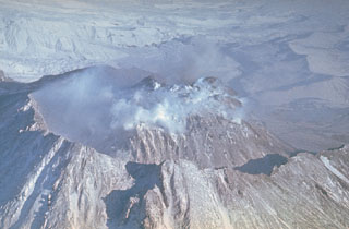 The Novy lava dome at Kamchatka's Bezymianny volcano began growing in 1956 within the large horseshoe-shaped crater. The 1.8 x 2.5 km crater formed during the catastrophic 1956 eruption flank collapse that resulted in a debris avalanche and lateral blast to the E. This 1980's view from the SW shows the dome within the crater, which subsequently grew to the height of the crater rim.
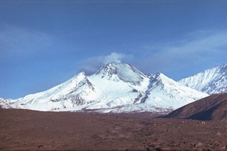 The Novy lava dome formed within the horseshoe-shaped crater that formed by collapse of the summit of Bezymianny in 1956. Intermittent dome growth since 1956 has filled much of the crater. This 11 September 1988 photo from the east shows the lava dome with a broad lava flow (lightly covered by snow) on the NE flank. The flow was produced by slow lava effusion during December 1986 to July 1988. The slopes of Kamen appear to the right.
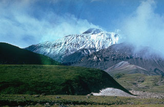 The south flank of Bezymianny contains several lava domes of Holocene age, one of which forms the unvegetated mass partly obscured by clouds to the left. The mostly snow-free summit lava dome rises above the south rim of the 1956 crater. The tip of Kamen is visible above the high point on the western crater rim to the left.
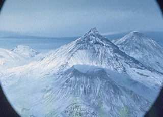 Four volcanoes of the Klyuchevskaya volcano group are visible in this north-looking view. A gas plume emanates from the summit of Bezymianny in the foreground, which is dwarfed by Kamen behind it. Klyuchevskoy is to the upper right, and Ushkovsky is on the left horizon. Krestovsky forms the rounded summit and the glacier-covered Ushkovsky caldera is visible to the far-left.
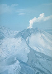 An explosive eruption at Bezymianny that began on 21 October 1993 deposited ash on Bering Island, 515 km to the ESE. Pyroclastic flows from the eruption traveled 14-16 km. Ash plumes rose to 8-15 km on 24 October and additional strong explosions took place on 28 and 29 October. This fall 1993 photo shows the pyroclastic flow and lahar pathways down the eastern flank.
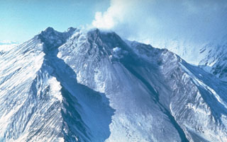 A lava dome fills much of the large horseshoe-shaped crater on the ESE side of Bezymianny in this late-1980s view from the SE. The crater formed during an eruption in 1955-56, which was similar to that of Mount St. Helens in 1980 with flank collapse and lateral blast components. Prior to this eruption Bezymianny had been considered extinct. Subsequent episodic lava dome growth, accompanied by intermittent explosive activity and pyroclastic flows, has largely filled the 1956 crater.
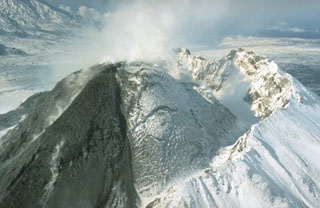 Growth of the Novy lava dome was accompanied by pyroclastic flows through much of 1990. On 10-11 March a short viscous lava flow was extruded, and a 10-km-high ash plume was accompanied by pyroclastic flows that traveled 4-5 km. Lava extrusion, hot avalanches, and occasional pyroclastic flows took place 1-12 April, 11-15 July, 15-20 August, and 26 November-3 December. This photo, taken from the NE on 21 September 1990, shows a dark lava flow descending the eastern flank of the dome.
 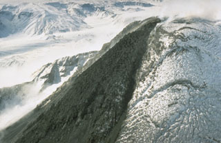 A black lava flow descends from the snow-mantled summit lava dome of Bezymianny volcano in Kamchatka in September 1990. The lava dome formed during the past forty years both by expansion when new magma was intruded into the dome and by the extrusion of lava flows down its flanks. The dome has grown within a large crater, whose southern rim is visible behind the lava flow.
 The small hummocks (hills) in this photo formed during a 1956 eruption of Bezymianny, an eruption that resembled the 1980 eruption of Mount St. Helens. The hummocky terrain is reminiscent of the debris avalanche deposit filling the Toutle River at St. Helens, and likewise was produced by a massive volcanic landslide when Bezymianny collapsed on 30 March 1956. The hummocks consist of material from the edifice that traveled out to 18 km E.
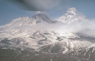 A weak plume rises from the summit lava dome of Bezymianny in September 1990. This view from the south shows Kamen to the right; to the left are the snow-mantled slopes of the outer flanks of the pre-1956 Bezymianny edifice. Collapse of the summit during a catastrophic eruption that year produced a large horseshoe-shaped crater that has subsequently been largely filled by growth of the lava dome.
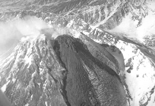 A viscous lava flow is extruded down the east flank of the Novy lava dome on 10 March 1987, within a trough that formed in the dome during the 1985 eruption. Extrusion of rigid blocks was first seen on 9 December 1986. On 16 December lava extrusion began, accompanied by explosions producing 5-6 km high ash plumes and pyroclastic flows that reached out to 4 km. Quiet lava extrusion continued until March 1988. In late July 1988 incandescence was seen at the top of the dome, accompanied by minor ash plumes.
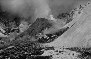 By the time of this 27 August 1956 photo, a new lava dome growing in the Bezymianny crater had reached a height of 320 m. The dome began growing in April, following a catastrophic eruption on 30 March in which the summit of the volcano collapsed, producing a massive debris avalanche and lateral blast towards the SE. The walls of the resulting horseshoe-shaped crater 1.3 x 2.8 km and 700 m deep that can be seen behind the lava dome. Gas emissions rise from the summit and base of the dome.
 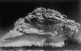 Following a period of explosive eruptions and lava-dome growth beginning in October 1955, a major explosive eruption took place on 30 March 1956 at Bezymianny volcano in Kamchatka. The Plinian eruption, seen here from 100 km W, produced a 40-km-high ash column, pyroclastic flow to a distance of 18 km, lateral blast, and a debris avalanche when the summit of the volcano collapsed.
 Kamen, seen here from the NE, is a steep-sided stratovolcano of largely Pleistocene age that rises immediately to the north of frequently active Bezymianny volcano (left). The summit of Kamen collapsed about 1,200 years ago, producing a massive debris avalanche to the east, and leaving the steep escarpment that forms the east face of the edifice.
  An ash plume erupts from the summit of Klyuchevskoy on 16 February 1987. Long-term activity includes both explosive and effusive activity from summit and flank vents. This view from the south shows Bezymianny producing a small plume at the lower left, Kamen at the left center, and the broader Ushkovsky on the left horizon.
 Kamen lies at the center of a N-S-trending chain of volcanoes, flanked by Bezymianny (left) and Klyuchevskoy. Kamen formed during the late Pleistocene and activity continued into the Holocene. A major flank collapse about 1,200-1,300 years ago removed much of the eastern side of the volcano, leaving the steep escarpment seen in this view.
The following 5 samples associated with this volcano can be found in the Smithsonian's NMNH Department of Mineral Sciences collections, and may be availble for research (contact the Rock and Ore Collections Manager). Catalog number links will open a window with more information.
| Catalog Number | Sample Description | Lava Source | Collection Date |
|---|---|---|---|
| NMNH 116514-2 | Andesite | BLOCK-ASH PYROCLASTIC FLOW | -- |
| NMNH 116514-3 | Tephra | DIRECTED BLAST DEPOSIT | -- |
| NMNH 116556-6 | Andesite | -- | -- |
| NMNH 116556-66 | Volcanic Bomb | -- | -- |
| NMNH 116556-7 | Andesite | -- | -- |
| Copernicus Browser | The Copernicus Browser replaced the Sentinel Hub Playground browser in 2023, to provide access to Earth observation archives from the Copernicus Data Space Ecosystem, the main distribution platform for data from the EU Copernicus missions. |
| MIROVA | Middle InfraRed Observation of Volcanic Activity (MIROVA) is a near real time volcanic hot-spot detection system based on the analysis of MODIS (Moderate Resolution Imaging Spectroradiometer) data. In particular, MIROVA uses the Middle InfraRed Radiation (MIR), measured over target volcanoes, in order to detect, locate and measure the heat radiation sourced from volcanic activity. |
| MODVOLC Thermal Alerts | Using infrared satellite Moderate Resolution Imaging Spectroradiometer (MODIS) data, scientists at the Hawai'i Institute of Geophysics and Planetology, University of Hawai'i, developed an automated system called MODVOLC to map thermal hot-spots in near real time. For each MODIS image, the algorithm automatically scans each 1 km pixel within it to check for high-temperature hot-spots. When one is found the date, time, location, and intensity are recorded. MODIS looks at every square km of the Earth every 48 hours, once during the day and once during the night, and the presence of two MODIS sensors in space allows at least four hot-spot observations every two days. Each day updated global maps are compiled to display the locations of all hot spots detected in the previous 24 hours. There is a drop-down list with volcano names which allow users to 'zoom-in' and examine the distribution of hot-spots at a variety of spatial scales. |
|
WOVOdat
Single Volcano View Temporal Evolution of Unrest Side by Side Volcanoes |
WOVOdat is a database of volcanic unrest; instrumentally and visually recorded changes in seismicity, ground deformation, gas emission, and other parameters from their normal baselines. It is sponsored by the World Organization of Volcano Observatories (WOVO) and presently hosted at the Earth Observatory of Singapore.
GVMID Data on Volcano Monitoring Infrastructure The Global Volcano Monitoring Infrastructure Database GVMID, is aimed at documenting and improving capabilities of volcano monitoring from the ground and space. GVMID should provide a snapshot and baseline view of the techniques and instrumentation that are in place at various volcanoes, which can be use by volcano observatories as reference to setup new monitoring system or improving networks at a specific volcano. These data will allow identification of what monitoring gaps exist, which can be then targeted by remote sensing infrastructure and future instrument deployments. |
| Volcanic Hazard Maps | The IAVCEI Commission on Volcanic Hazards and Risk has a Volcanic Hazard Maps database designed to serve as a resource for hazard mappers (or other interested parties) to explore how common issues in hazard map development have been addressed at different volcanoes, in different countries, for different hazards, and for different intended audiences. In addition to the comprehensive, searchable Volcanic Hazard Maps Database, this website contains information about diversity of volcanic hazard maps, illustrated using examples from the database. This site is for educational purposes related to volcanic hazard maps. Hazard maps found on this website should not be used for emergency purposes. For the most recent, official hazard map for a particular volcano, please seek out the proper institutional authorities on the matter. |
| IRIS seismic stations/networks | Incorporated Research Institutions for Seismology (IRIS) Data Services map showing the location of seismic stations from all available networks (permanent or temporary) within a radius of 0.18° (about 20 km at mid-latitudes) from the given location of Bezymianny. Users can customize a variety of filters and options in the left panel. Note that if there are no stations are known the map will default to show the entire world with a "No data matched request" error notice. |
| UNAVCO GPS/GNSS stations | Geodetic Data Services map from UNAVCO showing the location of GPS/GNSS stations from all available networks (permanent or temporary) within a radius of 20 km from the given location of Bezymianny. Users can customize the data search based on station or network names, location, and time window. Requires Adobe Flash Player. |
| DECADE Data | The DECADE portal, still in the developmental stage, serves as an example of the proposed interoperability between The Smithsonian Institution's Global Volcanism Program, the Mapping Gas Emissions (MaGa) Database, and the EarthChem Geochemical Portal. The Deep Earth Carbon Degassing (DECADE) initiative seeks to use new and established technologies to determine accurate global fluxes of volcanic CO2 to the atmosphere, but installing CO2 monitoring networks on 20 of the world's 150 most actively degassing volcanoes. The group uses related laboratory-based studies (direct gas sampling and analysis, melt inclusions) to provide new data for direct degassing of deep earth carbon to the atmosphere. |
| Large Eruptions of Bezymianny | Information about large Quaternary eruptions (VEI >= 4) is cataloged in the Large Magnitude Explosive Volcanic Eruptions (LaMEVE) database of the Volcano Global Risk Identification and Analysis Project (VOGRIPA). |
| EarthChem | EarthChem develops and maintains databases, software, and services that support the preservation, discovery, access and analysis of geochemical data, and facilitate their integration with the broad array of other available earth science parameters. EarthChem is operated by a joint team of disciplinary scientists, data scientists, data managers and information technology developers who are part of the NSF-funded data facility Integrated Earth Data Applications (IEDA). IEDA is a collaborative effort of EarthChem and the Marine Geoscience Data System (MGDS). |

