Theme Collections | Space Shuttle Photos
Theme collections are galleries not specifically related to volcanic hazards, processes, research, types, or features. This includes subjects such as different satellite platforms, astronaut photos from the Space Shuttle, specific photographers, or other special collections.
Image Gallery for Space Shuttle Photos
Between the first launch in 1981 and the final landing in 2011, NASA's Space Shuttle fleet flew 135 missions. Astronauts used hand-held cameras to photograph features of interest on Earth, including volcanoes and eruptions. GVP was often consulted to suggest targets for them! There are 69 images available.
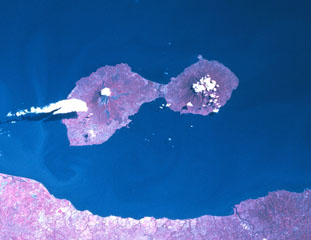
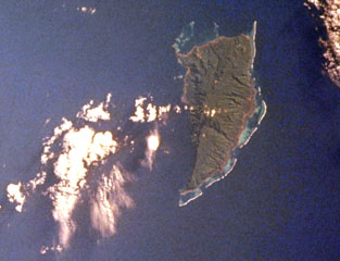
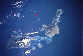
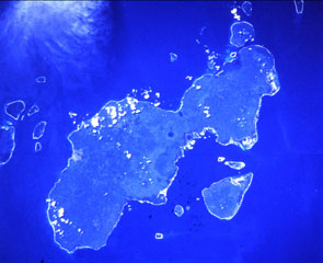
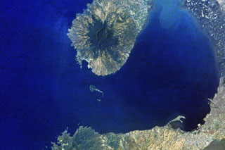
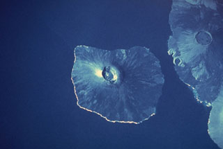
 The three small islands of Nguna, Pele, and Emau at the upper left, are located N of the large island of Efete (also known as Vate). Nguna and Pele appear to be a single island in this NASA Space Shuttle image (N is to the upper left), and Emau is the small circular island at the at the top center. These islands are thought to lie along or near the southern rim of a largely-submarine caldera of uncertain dimensions that extends to the N and may have formed about 2,000 years ago.
NASA Space Shuttle image STS068-206-50, 1994 (http://eol.jsc.nasa.gov/).
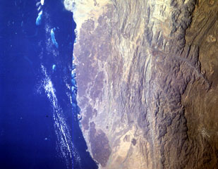
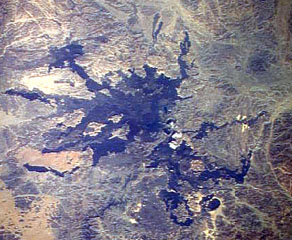
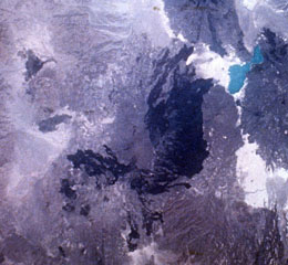
 The elongated N-S-trending volcanic chain below and to the right of turquoise-colored Lake Afrera includes the Tat Ali complex at the N and the Mat Ala at the S. Mat Ala contains a small 2.5 x 3.5 km wide caldera visible as a small light-colored dot near the southern end of the chain in this NASA Space Shuttle image. To the SW of Lake Afrera is Afderà volcano and Alayta volcano with its extensive dark-colored lava flows is farther to the west.
NASA Space Shuttle image S-19-35, 1984 (http://eol.jsc.nasa.gov/).
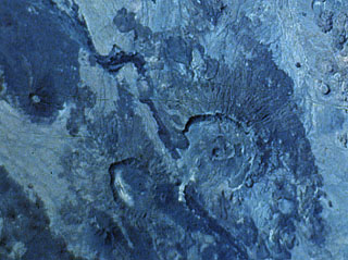
 The large caldera below and to the left of the center of this Space Shuttle photo of the Danakil Alps of Ethiopia is Nabro. This volcano is the highest in the Danakil depression and is truncated by nested calderas 10 and 5 km in diameter. The larger caldera is breached to the SW. The 8-km-wide Mallahle caldera is at the lower left, and the dark-colored lava flows at the right are from Dubbi volcano.
NASA Space Shuttle image S-61A-36, 1985 (http://eol.jsc.nasa.gov/).
 The smaller (left-hand) of the two large calderas at the bottom center of this NASA Space Shuttle image is Mallahle. The steep-walled 8-km-wide caldera truncates a stratovolcano. Basaltic lava flows blanket the slopes of the volcano, and flank vents are most numerous on its western side. Mallahle lies SW of the larger Nabro caldera (right-center) and is the central of three NE-SW-trending stratovolcanoes in the Danakil horst SW of Dubbi volcano.
NASA Space Shuttle image S-61A-36, 1985 (http://eol.jsc.nasa.gov/).
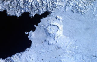
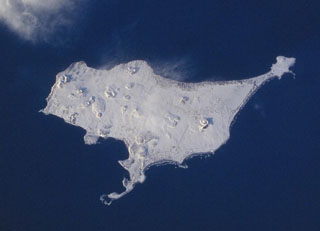 A Space Shuttle image of St. Paul Island shows Northeast Point to the upper right, Reef Point at the bottom-center, and Southwest Point to the left. Snow-covered Big Lake lies SW of Northeast Point, Bogoslof Hill near the center of the island, and Rush Hill is the cone along the NW coast. Rush Hill produced lava flows from NE-trending fissures. The 110 km2 island is the largest of the Pribilof Islands and contains more than a dozen scoria cones and associated lava flows.
NASA Space Shuttle image STS099-728-21, 2000 (http://eol.jsc.nasa.gov/).
 The forested volcanic massif at the center of the image is Mount Victory, which occupies the lower part of a peninsula SW of Cape Nelson (upper right). To the NE it abuts the deeply dissected Pleistocene Mount Trafalgar volcano, its summit draped by the larger cloud banks. The summit crater of Mount Victory contains a breached crater and several lava domes. The only confirmed historical activity of Mount Victory was a long-term late-19th to early 20th-century eruption that produced pyroclastic flows that reached the coast.
NASA Space Shuttle image STS093-710-19, 1999 (http://eol.jsc.nasa.gov/).
 The small island to the upper left is Blup Blup. This 3.5-km-wide forested island contains lava flows with well-defined flow fronts and a weak thermal area is located on the W coast. No historical eruptions have occurred, but the volcano may have been active during the Holocene. It is part of the Schouten Islands, along with Kadovar volcano (the small circular island to the S) and Bam volcano (right).
NASA Space Shuttle image STS106-719-49, 2000 (http://eol.jsc.nasa.gov/).
 Kadovar is the small circular island at the upper left just above the prominent sediment plume from the Sepik River (lower left) on the mainland of Papua New Guinea. The 2-km-wide island of Kadovar is the emergent summit of a Holocene-age stratovolcano that lacks fringing or offshore reefs. No certain historical eruptions are known, with the latest activity consisting of a period of elevated thermal activity in 1976. Kadovar is part of the Schouten Islands, along with Blup Blup (top left) and Bam (top right).
NASA Space Shuttle image STS106-719-49, 2000 (http://eol.jsc.nasa.gov/).
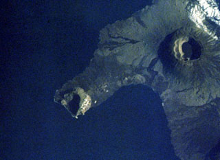
 Goriaschaia Sopka dome and the Milne cone are shown here on the SW end of Simushir Island. Milne is the larger snow-capped peak and Goriaschaia Sopka is on the NW flank within a large open crater. The dome has produced lava flows that form the irregular shoreline to the N, some of which are visible in this NASA Space Shuttle image.
NASA Space Shuttle image STS112-E-5671, 2002 (http://eol.jsc.nasa.gov/).
 The dark-colored forested area with scattered clouds on the rounded peninsula left of the sharp-tipped Tua Peninsula forming the SE tip of Sumatra is Rajabasa volcano. The NW tip of Java (right) lies across the Sunda Strait in this NASA Space Shuttle image with north to the upper left.
NASA Space Shuttle image STS106-705-29, 2000 (http://eol.jsc.nasa.gov/).
 An eruption at Iliboleng began on 11 May 1983 when an ash plume rose to 500 m. Ash and incandescent ejecta was reported on 13 July and fine ash occasionally fell from the plume on 15 July. On 4 September space shuttle astronauts photographed this small diffuse plume 50-70 km long, and an ash plume was reported again on 22 September. A 500 m ash plume was seen for a few minutes on 24 November, and additional plumes were emitted on 3 January and 13 April 1984 to a maximum height of 1 km.
NASA Space Shuttle image STS008-50-1840, 1983 (http://eol.jsc.nasa.gov/).
 The Harrat al Birk volcanic field forms the dark-colored area between the Red Sea coast and the center of this NASA Space Shuttle image (N to the upper right). This 1,800 km2 Miocene and Quaternary volcanic field separates the Tihamat ash Sham and Tihamat 'Asir coastal plains. Scoria cones occur throughout the field and a few outlying cones lie E of the main lava field.
NASA Space Shuttle image STS055-151-184, 1993 (http://eol.jsc.nasa.gov/).
 Pulau Weh is the island to the right in this NASA Space Shuttle image with N to the upper right. The NW tip of Sumatra is at the bottom of the image. Lhok Perialakot bay on the north side of the island has been interpreted as the remains of a partially-collapsed older volcanic center that opens to the NW. Volcanism was assumed to be of Pleistocene age, but fumaroles and hot springs are found at the SE part of the island and along the shores of Lhok Perialakot.
NASA Space Shuttle image STS065-107-39, 1994 (http://eol.jsc.nasa.gov/).
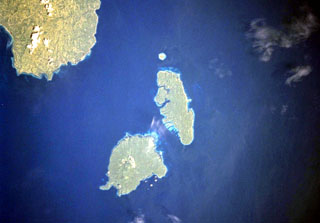 The Sarangani Islands lie about 20 km across Sarangani Strait from the Batulaki Peninsula (upper left), which forms the southern tip of Mindanao Island. Balut volcano occupies the lower island in this NASA Space Shuttle image (N is to the upper left). The volcano has hot springs and areas on the flanks have undergone thermal alteration.
NASA Space Shuttle image STS099-704-41, 2000 (http://eol.jsc.nasa.gov/).
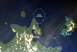 The mostly submarine Tavui caldera at the NE end of New Britain lies off the tip of the Gazelle Peninsula. The SW wall of the roughly 10 x 12 km wide caldera, its margins crudely shown on this image, cuts the NE tip of the peninsula. Tavui caldera, much less known than Rabaul caldera to the S, was first discovered during a bathymetric cruise in 1985. Light ash-covered areas from the 1994 Rabaul eruption can be seen at the western and NE margins of Rabaul caldera in this 1999 NASA Space Shuttle image.
NASA Space Shuttle image STS103-733-52, 1999 (http://eol.jsc.nasa.gov/).
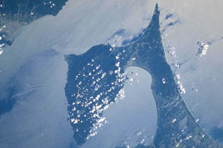 The prominent Shimokita Peninsula is located at the NE tip of Honshu just above and to the left of the center of this NASA Space Shuttle image, with N (and part of the island of Hokkaido) to the upper left. The volcano is Pleistocene in age, although fumarolic activity continues. Osoreyama volcano lies below Mutsu-Hiuchidake near the southern coast of the peninsula, north of Mutsu Bay.
NASA Space Shuttle image STS106-720-2, 2000 (http://eol.jsc.nasa.gov/).
 The Golan Heights basaltic volcanic field lies NE of Lake Tiberius (Sea of Galilee) in the Anti-Lebanon Mountains of SW Syria near the borders with Lebanon and Israel. Lake Tiberius, whose surface lies below sea level, is at the upper left in this NASA Space Shuttle image (N is to the upper right). The volcanic field contains 56 scoria cones of Pliocene-to-Holocene age and includes the prehistoric cone of Majdel Shams in the Golan Heights.
NASA Space Shuttle image STS060-97-24, 1994 (http://eol.jsc.nasa.gov/).
 Late Cenozoic volcanic rocks cover much of the Kukuia Peninsula (left center) on the SW side of Fergusson Island and areas north of the peninsula. The Iamalele-Fagululu area, located north of the peninsula and south of the Mailolo metamorphic block forming the NW tip of the island, contains a series of lava domes and lava flows and abundant hot springs and fumaroles. Eight small lava domes are located near Fagululu village and around Salt Lake. Young volcanic rocks are also present on Goodenough Island (upper left).
NASA Space Shuttle image STS44-83-80, 1991 (http://eol.jsc.nasa.gov/).
 Cerro Buena Vista (CBV) is an eroded Pleistocene stratovolcano located in the Jucuarán Range in the SE corner of El Salvador. The Jucuarán Range consists primarily of Pliocene volcanic rocks of the Bálsamo Formation. The 750-m-high Cerro Buena Vista volcano lies about 10 km north of the Pacific coast and SW of Laguna de Olomega, the 6-km-wide lake at the top-center. A broad crater at Cerro Buena Vista roughly 1 km wide is breached to the WSW. North is to the upper left in this NASA Space Shuttle Image.
NASA Space Shuttle image STS61C-31-47, 1986 (http://eol.jsc.nasa.gov/).
 An eruption at San Miguel on September 21-23, 1787 from summit and N- and SE-flank vents produced five lava flows. Ashfall caused extensive crop damage. Other historical lava flows from San Miguel are labeled in this Space Shuttle image with north to the upper left. The 1762 lava flow (faintly seen at the upper right) extended as far as the present-day city of San Miguel. The 2.5-km-wide caldera of Chinameca volcano lies NW of San Miguel volcano, and the small dark-colored dot at the upper right is Laguna de Aramuaca maar.
 NASA Space Shuttle image STS61C-31-47, 1986 (http://eol.jsc.nasa.gov/).
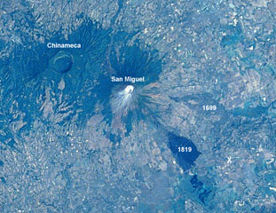 A large eruption took place from San Miguel in 1699, accompanied by strong earthquakes, flames, and rumblings. A major lava flow (right-center) traveled from SE-flank fissures for a straight-line distance of nearly 9 km. The flow divided around a light-colored kipuka and then banked against Pleistocene volcanic hills, where it was deflected to the south in a narrow lobe to the point labeled "X." The 2.5-km-wide caldera of Chinameca volcano lies across a saddle from San Miguel in this Space Shuttle image with north to the upper left.
 NASA Space Shuttle image STS61C-31-47, 1986 (http://eol.jsc.nasa.gov/).
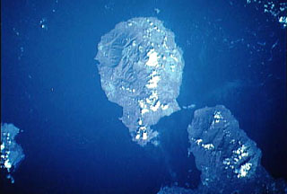 Goodenough (center) is the roughly circular volcanic island that is the westernmost of the D'Entrecasteaux Islands in this NASA satellite image with north to the upper right. Several Holocene eruptive centers that may be only a few hundred years old are located around the margins of fault-bounded metamorphic rocks that form the central part of Goodenough Island. The youngest volcanic features, which include the Walilagi Cones, are located at the SE end of the island on the Bwaido Peninsula (lower center).
NASA Space Shuttle image STS44-83-79, 1991 (http://eol.jsc.nasa.gov/).
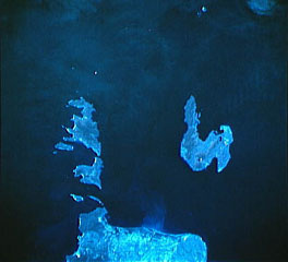
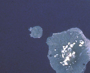
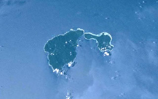 Ambitle (left center) is the larger of two adjacent islands forming the Feni Islands. The 13-km-long island is dominantly Pliocene-to-Pleistocene with a 3-km-wide central caldera. A maar on the E side of post-caldera lava domes formed about 2,300 years ago. Thermal areas are active within the caldera and just off the W coast. Babase Island, immediately to the NE of Ambitle, is a Pleistocene volcano and lava dome connected by a narrow isthmus.
NASA Space Shuttle image STS88-706-56, 1998 (http://eol.jsc.nasa.gov/).
 The 20-km-long Lihir Island is a complex of several overlapping Pliocene-to-Holocene volcanoes N of Latangai Island, the youngest of which is Luise volcano. Luise Harbor (right center) lies within a 5.5-km-wide caldera that is breached on the NE side. Thermal activity includes boiling hot springs, mud pools, and sulfur-encrusted low-temperature fumaroles.
NASA Space Shuttle image STS001-5933, 2001 (http://eol.jsc.nasa.gov/).
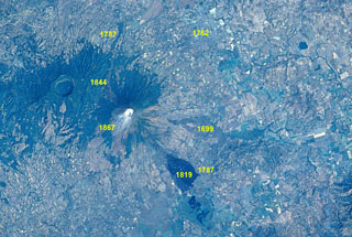
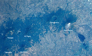 An E-W-trending chain of volcanoes extends about30 km across eastern El Salvador. The 2-km-wide Laguna Seca el Pacayal caldera is a prominent feature of Chinameca volcano. San Miguel is one of El Salvador's most active volcanoes; the dark area at the lower right is a lava flow from the 1819 eruption. The city of San Miguel is to the upper right.
NASA Space Shuttle image STS61C-31-47, 1986 (http://eol.jsc.nasa.gov/).
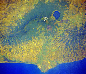 Four volcanoes in western El Salvador are visible in this Space Shuttle image. The forested ridge at the left-center is the Apaneca Range, a complex of calderas and small stratovolcanoes. The summit crater of Santa Ana volcano lies below the small cloud bank, and the brownish area below it is Izalco volcano. A circular lake partially fills Coatepeque caldera. The Acajutla Peninsula at the bottom, named after the port city of Acajutla, was formed by a massive debris avalanche produced by the late-Pleistocene collapse of Santa Ana volcano.
NASA Space Shuttle image STS61C-31-45, 1986 (http://eol.jsc.nasa.gov/).
 Two major scarps cutting Mombacho volcano (left-center) were the sources of major debris avalanches. The arcuate peninsula and island chain extending into Lake Nicaragua (known as Las Isletas or Isletas de Granada) was produced by collapse of Mombacho to the NE. The island at the right is Zapatera, a small shield volcano and maar complex. The lake at the far left fills late-Pleistocene Apoyo caldera, and the roughly N-S-trending Granada cinder cone alignment lies NNW of Mombacho and east of Lake Apoyo in this NASA Space Shuttle image (with north to the upper left).
NASA Space Shuttle image STS081-742-25, 1997 (http://eol.jsc.nasa.gov/).
 The dumbbell-shaped island of Ometepe, the largest in Lake Nicaragua (also known as Colcibolca), consists of two large stratovolcanoes, Concepción on the left and Maderas on the right. The two volcanoes were constructed on an unstable substrate of Tertiary-to-Cretaceous marine rocks and younger lake sediments, which has promoted spreading and deformation of the volcanic edifices. A low narrow isthmus connects Concepción to Maderas volcano. North lies to the upper left in this Space Shuttle image.
NASA Space Shuttle image STS081-742-25, 1997 (http://eol.jsc.nasa.gov/).
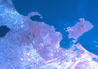
 Young volcanoes dot the surface and anchor the shores of the Gulf of Fonseca, which forms the coastline of three countries. Conchagua volcano occupies the wedge-shaped peninsula (left-center) in eastern El Salvador, while Cosigüina volcano forms the prominent peninsula across the bay in Nicaragua. Clockwise from the top are the islands of Zacate Grande and El Tigre in Honduras and Meanguera and Conchaguita in El Salvador. The mouth of the Gulf of Fonseca is about 30 km wide.
NASA Space Shuttle image STS82-731-83, 1997 (http://eol.jsc.nasa.gov/).
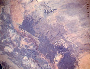 The darker-colored area extending diagonally down the center of this Space Shuttle image is Harrat ar Rahah, the northernmost of a series of Quaternary volcanic fields paralleling the Red Sea coast of Saudi Arabia. The geometrical outlines of the historical town of Tabuk (top center), located on the road leading from Hijr to Damascus, can be seen to the N. There are fewer young volcanoes in Harrat ar Rahah than in other harrats (lava fields) to the S.
NASA Space Shuttle image STS37-152-177, 1991 (http://eol.jsc.nasa.gov/).
 Hiri (left-center), a small 3-km-wide forested island immediately north of Ternate Island (lower right), is the northernmost of a chain of volcanic islands off the western coast of Halmahera. North is to the upper left in this Space Shuttle image. Little is known of this volcano, although it was mapped as Holocene in age. In contrast to Hiri, the better-known Gamalama volcano that forms Ternate Island has been active during historical time, including a 1775 eruption from the small lake-filled maar visible on the NW coast of the island.
 NASA Space Shuttle image STS050-99-95, 1992 (http://eol.jsc.nasa.gov/).
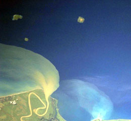
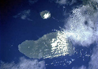
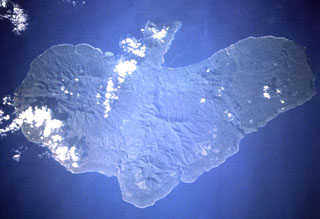 The peninsula at the top of this Space Shuttle image of Erromango Island (N is approximately to the left) is the Traitor's Head Peninsula. Three Holocene cones at Traitor's Head are the youngest on the 50-km-long island. The volcanoes initially formed an offshore island that later joined the mainland through uplift. The only documented activity at Erromango was a submarine vent that erupted in 1881.
NASA Space Shuttle image STS68-220-4, 1994 (http://eol.jsc.nasa.gov/).
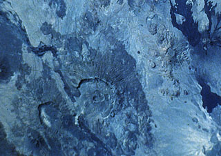
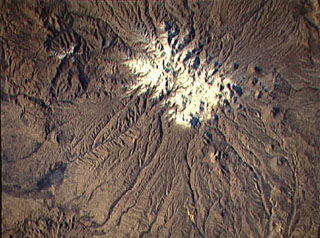
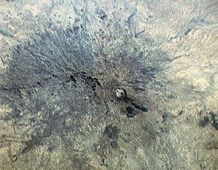
 The circular area near the center of this Space Shuttle image is the shallow 14 x 18 km wide summit caldera of Tarso Voon volcano in the west-central part of the Tibesti Range. Quaternary basalts were erupted from vents near the caldera rim and from Ehi Mousgau, a small stratovolcano visible to the NW. The large Soborom solfatara field west of the massif, with its active mud pots and boiling waters, is visited by Tibesti peoples for medicinal uses. Pleistocene Tarso Yéga caldera to the SE is at the lower right.
NASA Space Shuttle image STS41B-42-2521 1984 (http://eol.jsc.nasa.gov/).
 The large dark wedge-shaped area near the center of this Space Shuttle image is Harrat 'Uwayrid, a major volcanic field in NW Saudi Arabia that contains basaltic scoria and tuff cones. Bedouin legends say that Hala-'l-Bedr erupted fire and stones in 640 CE, killing herdsmen and their cattle and sheep. Another volcanic field, Harrat ar Rahah (top-left), lies to the NW.
NASA Space Shuttle image STS37-152-84, 1991 (http://eol.jsc.nasa.gov/).
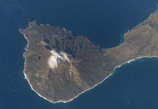
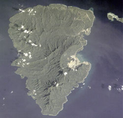
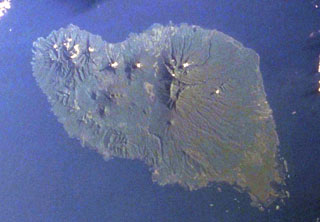
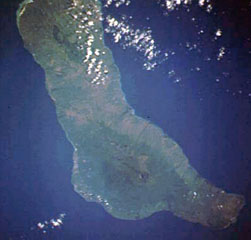
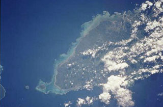 The massive, basaltic shield volcano forming 75-km-long Upolu Island in Samoa is seen in this Space Shuttle view (with north to the upper left). The youngest lava flows, erupted after a lengthy period of erosion, originated from vents near the crest of the island and may be only a few hundred to a few thousand years old. Apolima Island, the small circular island west of reef-bounded Manono Island off the western tip of Upolu (lower right), is a Holocene tuff cone too young to be fringed by a coral reef.
NASA Space Shuttle image STS111-715-29, 2002 (http://eol.jsc.nasa.gov/).
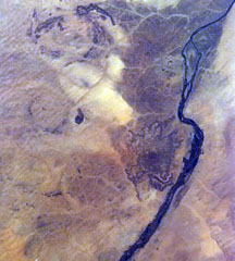 The dark area at right-center to the left of the bend in the Nile River in NE Sudan is the Jebel Umm Arafieb volcanic field, also known as Jebel Umm Marafieb. Located in the Bayuda Desert NE of the capital city of Khartoum, this volcanic field consists of a low-angle shield volcano formed of several overlapping aa lava flows erupted from a vent now capped by a spatter cone.
 NASA Space Shuttle image STS81-ESC-8221240, 1997 (http://eol.jsc.nasa.gov/).
 The 50-km-long island of Umboi, the largest of the volcanic islands off the north coast of New Guinea, is seen in this Space Shuttle image (N is to the top-right). A large 13 x 17 km caldera is visible in the northern half of the island and is breached to the NE (top center). Three post-caldera cones with summit crater lakes (left center) are visible on the smooth-surfaced caldera floor. The large eroded massif (right center) is an older volcanic complex, as is the dissected northern tip of the island (upper left).
NASA Space Shuttle image STS50-99-748-47, 2000 (http://eol.jsc.nasa.gov/).
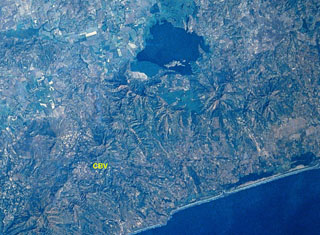
 Magaso, also known as Cuernos de Negros, is a large stratovolcano that anchors the SE tip of Negros Island. The volcano is located just right of center in the cloud-covered portion of SE Negros Island in this Space Shuttle image (with north to the upper right), directly across the channel and in line with the SW tip of Cebu Island at the right side of the image. No historical eruptions are known from Magaso, but the summit crater is fumarolically active, and the Palinpinon geothermal field are located at its base.
NASA Space Shuttle image STS61-40-74, 1985 (http://eol.jsc.nasa.gov/).
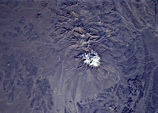 The snow-capped, eroded Taftan volcano in eastern Iran has two prominent summits. It was constructed along a volcanic zone in Beluchistan, SE Iran, that extends into northern Pakistan. The higher SE summit cone is well preserved and has been the source of very visible lava flows. Highly active, sulfur-coated fumaroles occur at the summit of the SE cone.
NASA Space Shuttle image STS80-752-40, 1996 (http://eol.jsc.nasa.gov/).
 Sahand volcano (Kuh-e-Sahand) is located in NW Iran, about 60 km E of Lake Urmia and 40 km SSE of the city of Tabriz. The city of Maragheh (darker area at bottom left) lies below the S flanks of the volcano. Numerous lava domes (upper right) occupy the lower flanks of the volcano.
NASA Space Shuttle image STS74-708-25, 1995 (http://eol.jsc.nasa.gov/).
 Low-angle sun accentuates small pyroclastic cones on snow-covered Nunivak Island. Shelf ice modifies the apparent northern coastline (top) in this January 1992 Space Shuttle image. The 110-km-wide island lies about 30 km off the coast of SW Alaska and contains about 60 cinder cones and four maars. Although the bulk of the volcanic field was formed during two Pleistocene eruptive periods ending about 300,000 years ago, activity continued into the Holocene. The latest eruptions occurred along an E-W line in the southern part of the island.
NASA Space Shuttle image STS42-82-33, 1992 (http://eol.jsc.nasa.gov/).
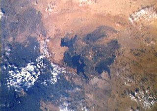
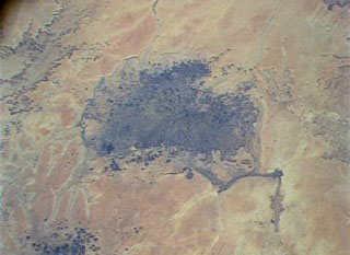 The dark-colored area in the center of this Space Shuttle view is the alkaline Meidob volcanic field in western Sudan. This broad volcanic field covers an area of 5,000 km2 with nearly 700 Pliocene-to-Holocene vents. The margins of the field are dominated by basaltic scoria cones and associated lava flows, but the lava domes, tuff rings, and maars that are concentrated along the central E-W-trending axis of the volcanic field are among the youngest features. The latest dated eruptions took place about 5,000 years ago.
NASA Space Shuttle image STS073-713-87, 1995 (http://eol.jsc.nasa.gov/).
 A Space Shuttle perspective shows part of Marsabit, a massive, 6,300 km2 shield volcano located 170 km E of the center of the East African Rift. Its slopes are dotted with 180 cinder cones and 22 maars, such as the prominent circular one below the thickly vegetated summit of the shield volcano. Most of these vents are concentrated along NW- and NE-trending belts cutting across the summit. The youngest lava flows are unvegetated, and the post-shield cinder cones were mapped as Pleistocene to Holocene in age.
NASA Space Shuttle image STS026-37-2, 1988 (http://eol.jsc.nasa.gov/).
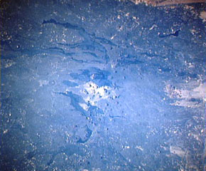
 Lava flows radiate down desert valleys away from the center of Harrat Lunayyir, a basaltic volcanic field in NW Saudi Arabia, east of the Red Sea port of Umm Lajj. Harrat Lunayyir contains about 50 volcanic cones that were constructed along a N-S axis. Harrat Lunayyir is one of the smallest of the Holocene lava fields of Saudi Arabia, but individual flow lobes extend up to about 30 km from the center of the Harrat. One of the cones may have erupted around the 10th century CE or earlier.
NASA Space Shuttle image STS26-41-61, 1988 (http://eol.jsc.nasa.gov/).
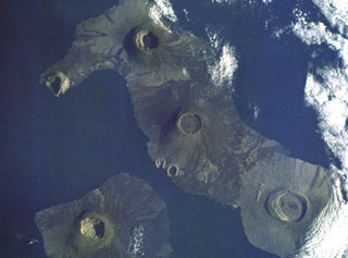
 The 16 x 9 km Koro Island is located between Fiji's two major island groups. A chain of scoria cones of late-Pleistocene or possibly Holocene age extends along the crest of the island from the NE tip (upper right) to the southern tip. The youngest lava flows are mostly confined to the plateau in the center of the island.
 NASA Space Shuttle image STS111-719-74, 2002 (http://eol.jsc.nasa.gov/).
 The NW part of the 5,900 km2 Harrat Kishb volcanic field is seen in this Space Shuttle image. The field is located E of a N-S-trending line of volcanic fields in central Saudi Arabia. The medium-brown-colored Jabal Aslaj scoria cone visible near the top of the dark lava flows near the center of the image was the source of the flows seen here. A second area of young flows seen at the lower right surrounds the circular Al Wahbah maar. These lava flows are stratigraphically younger than a 6,500-4,000-year-old pluvial period.
NASA Space Shuttle image STS102-708-13, 2001 (http://eol.jsc.nasa.gov/).
 Harrat Khaybar, one of Saudi Arabia's largest volcanic fields, covers an area of more than 14,000 km2 to the N of Madinah (Medina). This Space Shuttle image shows the central vent area of the volcanic field. Light-colored areas at the center of the image show lava domes and tuff rings; above this area is Jabal Qidr volcano. The lava flows extending to the W from the central vent area are young prehistoric and historic. An eruption was reported in early Mohammedan times during the 7th century CE.
NASA Space Shuttle image STS38-74-6, 1990 (http://eol.jsc.nasa.gov/).
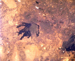
 The small circular area just right of the center of this Space Shuttle image is Deriba caldera, the most prominent feature of the vast Jebel Marra volcanic field in western Sudan. The 5-km-wide, steep-walled caldera was formed about 3,500 years ago during an eruption that produced voluminous airfall pumice and pyroclastic flows that traveled more than 30 km from the volcano. Ash eruptions may have continued into early historical time, and fumarolic activity continues on the flanks of the caldera.
NASA Space Shuttle image STS32-94-24, 1990 (http://eol.jsc.nasa.gov/).
 The 4,000 km2 Harrat Ithnayn volcanic field appears in the center of this Space Shuttle image with north to the upper right. Harrat Ithnayn contains scattered shield volcanoes and scoria cones that have produced extensive lava flows, some of which are less than 4,500 years old. Harrat Ithnayn merges with the larger Harrat Khaybar volcanic field to its south, the dark partially cloud-covered area at the lower left.
NASA Space Shuttle image STS-61A-483-20 (http://eol.jsc.nasa.gov/).
 An "X" marks the approximate location of Iriomote-jima submarine volcano, the southernmost Ryukyu Islands volcano. The submarine volcano is located north of the NE tip of 30-km-wide Iriomote-jima island (lower left) and WSW of the northern tip of the island of Ishigaki-shima (right-center). A major submarine eruption that was volumetrically one of the largest in Japan during historical time took place at this volcano on October 31, 1924. It produced pumice rafts that were carried by currents along both coasts of Japan as far north as Hokkaido.
 NASA Space Shuttle image STS66-117-19, 1994 (http://eol.jsc.nasa.gov/).
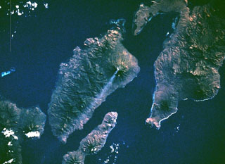
 The small circular island at the top-center is Sakar, the NE-most of a chain of volcanic islands off the northern coast of Papua New Guinea. The 8 x 10 km wide island, seen in this Space Shuttle image with north to the upper left, is an incised stratovolcano with a summit crater lake. The 50-km-wide island of Umboi, whose left side is cut by a large caldera breached to the NE, fills the center of the image.
NASA Space Shuttle image STS50-100-D, 1992 (http://eol.jsc.nasa.gov/).
 The dumbbell-shaped, E-W-trending Jolo island contains numerous pyroclastic cones and craters, some of which are visible in this Space Shuttle image with north to the upper left. The island is about 60 km wide in an E-W direction; its largest city, Jolo, lies on the northern coast (left-center). The isolated location of Jolo at the SW end of the Philippines archipelago as well as political unrest have inhibited geological studies of the volcano.
 NASA Space Shuttle image STS50-99-94, 1992 (http://eol.jsc.nasa.gov/).
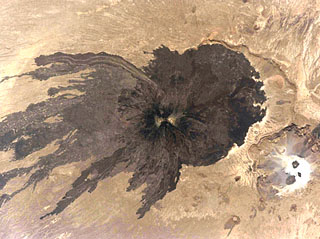 A dramatic Space Shuttle image shows dark lava flows radiating from Toussidé volcano and spreading across the desert floor. Light-colored altered areas can be seen at the summit, the second highest peak of the Tibesti Range in Chad. It was constructed at the W end of the large Pleistocene caldera of Yirrigue, whose E scarp is seen right of Toussidé. The smaller 1-km-deep, 8-km-wide Trou au Natron caldera (lower right) cuts the SE rim of the caldera.
NASA Space Shuttle image STS111-367-29, 2002 (http://eol.jsc.nasa.gov/).
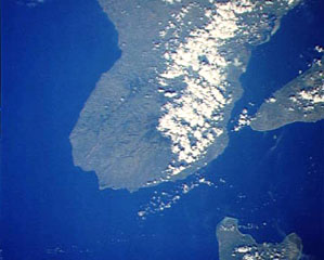
 Grand Comore Island in the Indian Ocean NW of Madagascar is formed by two massive shield volcanoes. The more well-known and historically active Karthala volcano at the southern end of the island has a 3 x 4 km summit caldera. Elongated rift zones extend to the NNW and SE; the lower SE rift zone forms the Massif du Badjini, a peninsula at the SE tip of the island (bottom right). The Holocene La Grille volcano forms the northern part of the island. Youthful lava flows from both volcanoes have reached the coast.
NASA Space Shuttle image STS009-39-2516, 1983 (http://eol.jsc.nasa.gov/).
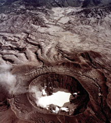
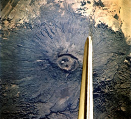 The vertical stabilizer of the Space Shuttle Endeavor appears above the summit caldera of Emi Koussi volcano at the SE end of the Tibesti Range in Chad. Nested 12 x 15 km wide calderas at the summit contain large craters and young basaltic scoria cones.
NASA Space Shuttle image STS108-701-008, 2001 (http://eol.jsc.nasa.gov/).
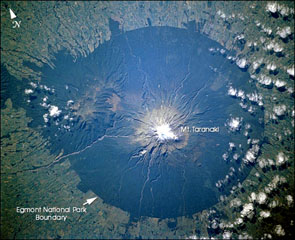 Mount Taranaki is the centerpiece of Egmont National Park on the W side of the North Island of New Zealand. Farmlands surrounding the volcano extend to the boundaries of the national park, leaving a circular pattern prominent from space. The Pleistocene Kaitoke Range forms the topographic high to the WNW.
NASA Space Shuttle image STS110-726-6, 2002 (http://eol.jsc.nasa.gov/).
 Volcán Ecuador (left center) forms the tip of a peninsula straddling the equator at the NW end of Isabela Island. The western side of the volcano, the smallest of the six large shield volcanoes on Isabela, is breached nearly to sea level. A line of fissure-fed vents on the outer eastern flank can be seen connecting Volcán Ecuador with Volcán Wolf (upper right). Despite the absence of historical eruptions from Volcán Ecuador, the youthful morphology of its most recent lava flows resembles those of very recent flows on other Isabela Island volcanoes.
NASA Space Shuttle image S-27-42-018, 1984 (http://eol.jsc.nasa.gov/).
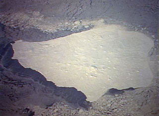
 This dramatic Space Shuttle photo from a 1988 mission shows five major calderas of the Galápagos Islands. Caldera diameters capping these basasltic shield volcanoes range up to 8 km. At the lower left is Fernandina volcano. At the lower right is mostly vegetated Alcedo volcano on Isabela Island. Above and to the left is Darwin volcano, with the two prominent breached tuff cones, Tagus and Beagle, on its SW flank. Volcán Wolf is at the top of the photo, and Volcán Ecuador with its breached caldera forms the NW tip of Isabela Island.
NASA Space Shuttle image, 1988 (http://eol.jsc.nasa.gov/).
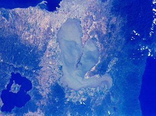 The center Laguna de Bay in the center of the NASA Space Shuttle image (N is to the upper right) is Laguna Caldera. The lake surface is only 1 m above sea level and may have formed during at least two major explosive eruptions about 1 million and 27,000-29,000 years ago. The city of Manila lies along Manila Bay at the top center, and the large caldera at the lower left is Taal. To the right is the Pacific Ocean.
NASA Space Shuttle image, 1992 (http://eol.jsc.nasa.gov/).
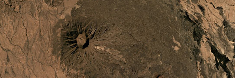
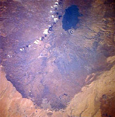
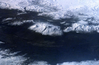
 The massive Alayta shield volcano (center) covers an area of 2,700 km2 in the western Danakil depression SW of Lake Afrera (upper right). The volcanic consists of two parts--an elongated shield volcano on the west (medium-toned) and an extensive lava field forming the dark-colored area on the eastern flank of the shield volcano. The Alayta lava field, covered by very fresh lava flows (the most recent of which was erupted in 1907), was erupted from N-S-trending fissures and laps up against the western flank of Afderà volcano (immediately SW of Lake Afrera).
NASA Space Shuttle image S-19-35, 1984 (http://eol.jsc.nasa.gov/).
 The low-profile Mariveles volcano forms the southern end of the Bataan Peninsula, on the W side of Manila Bay, and contains a 4-km-wide caldera that opens to the N. A Holocene eruption has been radiocarbon dated at 4,000 years before present. The city of Manila at the lower right lies 50 km across the bay from the volcano.
NASA Space Shuttle image, 1992 (http://eol.jsc.nasa.gov/).
 The prominent caldera in the center of the photo is Nemrut Dagi, the westernmost of a group of volcanoes near Lake Van. Nemrut Dagi lies north of the western part of Lake Van and is the only one of the group that has erupted in historical time. The 5 x 9 km caldera is partially filled by a lake, which appears as the smooth snow-covered right side of the caldera floor in this Space Shuttle photo with north to the bottom. Ash layers in Lake Van document numerous Holocene eruptions, the last of which took place in 1441 CE.
NASA Space Shuttle image STS45-80-08, 1992 (http://eol.jsc.nasa.gov/).
 The snow-covered Mount Ararat massif is seen in the center of this 1992 Space Shuttle photo from the NE. The double-peaked stratovolcano is Turkey's highest, largest volume, and eastern-most volcano, near the borders with Armenia and Iran. Postglacial lava flows were erupted from flank fissures, and well-preserved craters are located on the flanks.
NASA Space Shuttle image, 1992 (http://eol.jsc.nasa.gov/).
 Dark lava flows radiate from Toussidé volcano (center), the second highest peak of the Tibesti Range in Chad. N to the bottom of this Space Shuttle image. It was constructed at the W end of the large Pleistocene caldera of Yirrigue, whose scarp is seen left of Toussidé. The smaller 8-km-wide caldera of Trou au Natron cuts the SE rim of the caldera. Ehi Timi (lower center) and Ehi Sosso (left center) volcanoes are located on the flanks of the massif.
NASA Space Shuttle image S-511-42, 1985 (http://eol.jsc.nasa.gov/).
 Dark-colored lava flows of the Haruj volcanic field are prominent in this Space Shuttle photo of the arid desert of central Libya. The extensive Pliocene-to-Holocene Haruj volcanic field covers a broad 45,000 km2 area and contains very well-preserved scoria cones, lava flows, and explosion craters. The youngest lava flows were considered to be Holocene in age.
NASA Space Shuttle image STS41C-32-1146, 1984 (http://eol.jsc.nasa.gov/).
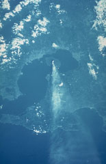
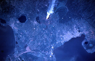 A vigorous steam plume pours from Masaya volcano in this November 9, 1984 Space Shuttle image taken near the end of a two-decade-long eruptive episode. North lies to the lower right, with Lake Nicaragua at the lower left and Lake Managua at the lower right. To the left of the plume from Santiago crater is Lake Masaya (ponded against the rim of Masaya caldera) and the circular lake-filled Apoyo caldera. The two caldera lakes at the lower right are Apoyeque (light blue) and Jiloa (dark-colored), across the bay from the city of Managua.
NASA Space Shuttle image STS51A-32-64, 1984 (http://eol.jsc.nasa.gov/).
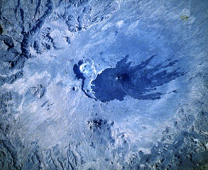
 This view from the west on 4 November 1982 shows the impact of the El Chichón eruption about seven months later. Fumaroles are present around the new lake partially filling the crater, and the surrounding area was devastated by pyroclastic flows and surges. The 1982 crater is located within an older 1.5 x 1.9 km crater.
NASA Space Shuttle image, 1982 (http://eol.jsc.nasa.gov/).
 Two massive Galápagos shield volcanoes, their slopes darkened by young unvegetated lava flows that reach to the sea, appear in this space-shuttle photograph. Fernandina volcano, the most active in the Galápagos Islands, forms a 30 x 34 km wide island with a 4 x 6.5 km wide caldera at its summit. Darwin volcano, north of the midpoint of Isabela Island, has a 5-km-wide summit caldera. The tuff cones of Tagus and Beagle are prominent along its western coast. The light-colored area south of Darwin is the lower western flank of Alcedo volcano.
NASA Space Shuttle image, 1989 (http://eol.jsc.nasa.gov/).
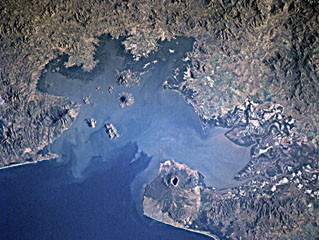
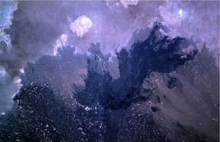
 A space shuttle photograph taken on 6 October 1985 shows an ash plume dispersing E from Sakurajima across the Osumi Peninsula to the Pacific Ocean. Sakurajima is near the S rim of the 20-km-wide Aira caldera that encompasses much of the N end of Kagoshima Bay. The caldera formed during an eruption about 22,000 years ago. Kagoshima City is the lighter-colored area across the bay immediately W.
NASA Space shuttle image, 1985 (http://eol.jsc.nasa.gov/).