Theme Collections | Bill Rose Photos
Theme collections are galleries not specifically related to volcanic hazards, processes, research, types, or features. This includes subjects such as different satellite platforms, astronaut photos from the Space Shuttle, specific photographers, or other special collections.
Image Gallery for Bill Rose Photos
Photos by Bill Rose (Michigan Technological University). There are 123 images available.
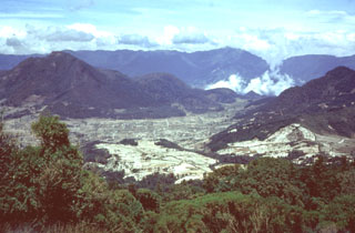
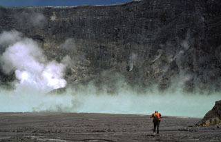
 The degassing crater lake at the summit of Poás volcano is seen here in 1982. The 800-m-wide crater lies near the center of the smaller of two calderas at the summit. One of the world’s most acidic natural lakes, the diameter and depth varies with seasonal rainfall and eruptive activity; on occasion the lake has disappeared.
 Photo by Bill Rose, 1982 (Michigan Technological University).
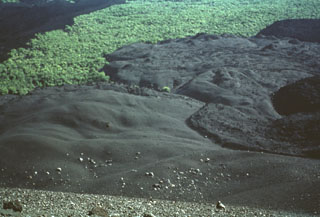
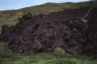
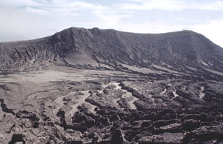
 An October 1971 photo from the crater rim shows a fresh black lava flow extruded onto the crater floor. Fumaroles rise from the surface of the flow at the right. Masaya began a long-duration eruptive period in 1965. Several lava flows, such as this one, were erupted between 1965 and 1972. An active lava lake was visible until 1979, and intermittent small explosive eruptions lasted until 1985.
Photo by Bill Rose, 1971 (Michigan Technological University).
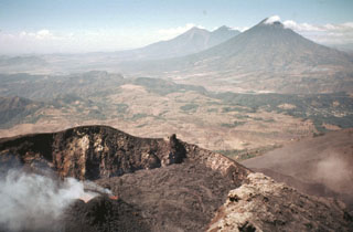
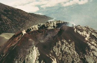
 A jointed lava flow underlain and capped by pyroclastic ejecta is exposed in the western crater wall of Telica's NE summit crater, the source of most of the volcano's recent eruptions. The crater is about 300 m wide and several hundred meters deep.
Photo by Bill Rose, 1978 (Michigan Technological University).
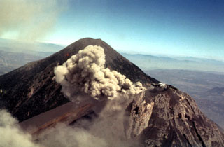
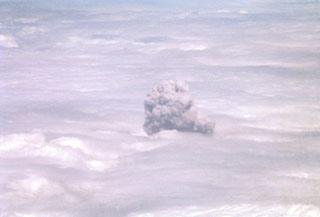 A convecting ash-bearing eruption cloud from Telica volcano punches through a low cloud layer in February 1982. Continuous white vapor columns with occasional ash were observed beginning in late November 1982, and small gas-and-ash eruptions took place in late December and early January. Large eruptions on February 12 and 19 sent clouds to 3.7-4.3 and 3.5 km above sea level, respectively. Eruptive activity ended on March 2.
Photo by Bill Rose, 1982 (Michigan Technological University).
 The lava flow at the right, partially mantled by tephra, was erupted in July 1947. A strong explosive eruption produced ashfall that damaged crops at Malpaisillo. The 1947 lava flow originated from a parasitic cone and traveled to the NE. This photo from the northern side of Cerro Negro also shows darker-colored lava flows from the 1957 eruption at the extreme right and at the upper left.
Photo by Bill Rose, 1971 (Michigan Technological University).
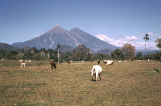
 The northern slopes of the symmetrical cone of San Miguel are seen here from the city of San Miguel north of the volcano. A deep crater that has been frequently modified by historical eruptions (recorded since the early 16th century) caps the truncated summit of the basaltic-to-andesitic volcano. Radial fissures on its flanks have fed a series of fresh lava flows, including a NE-flank flow in 1762 that currently underlies the outskirts of the city of San Miguel, the third largest in El Salvador.
Photo by Bill Rose, 1971 (Michigan Technological University).
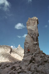
 The two tiny islands in the center of Lake Ilopango barely visible above the house in the foreground are the Islas Quemadas. These are post-caldera lava domes that were emplaced from 31 December 1879 to March 1880. A huge ash plume with incandescent ejecta were erupted on 20 January and the dome breached the lake surface on 23 January. It reached a height of 50 m above the lake surface before violent explosions on 5 March destroyed most of the visible part of the dome.
Photo by Bill Rose, 1978 (Michigan Technological University).
 The SW corner of Ilopango caldera is visible in the foreground with the outskirts of the capital city of San Salvador behind it. The high peak on the left horizon (NW) is El Picacho, part of the San Salvador volcanic complex, a recently active volcano overlooking the capital city. Below it to the left is San Jacinto, a Pliocene lava dome complex. The broad peak in the background to the right is the Pliocene Cerro Nejapa volcano.
Photo by Bill Rose, 1978 (Michigan Technological University).
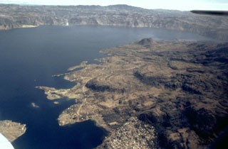
 The western side of Lake Ilopango is seen from the southern rim of Ilopango caldera. The broad peak on the right-hand horizon is the Pleistocene Guazapa volcano. The northern wall of Ilopango caldera rises about 400-500 m above the lake. Much of the caldera rim contains thick caldera-forming eruption deposits, and some lava domes are exposed in the caldera wall.
Photo by Bill Rose, 1978 (Michigan Technological University).
 An aerial view of the western side of Coatepeque caldera shows Cerro Grande lava dome, the island to the left. On the ridge behind the caldera wall are (from left to right) the San Marcelino-Cerro la Olla and Cerro el Conejal-Cerro el Astillero complexes, the summit of Izalco volcano, rounded Cerro Verde scoria cone, and (in the clouds) the summit of Santa Ana volcano. The Pacific Ocean is visible in the distance.
Photo by Bill Rose, 1967 (Michigan Technological University).
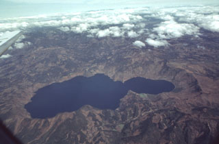 Scenic Laguna de Ayarza fills a double caldera formed during the late Pleistocene. The caldera lies about 40 km NE of the active volcanic front. The older eastern caldera (left) was associated with eruption of the Mixta pumice fall and ashflow about 27,000 years ago, and the larger western caldera was formed during eruption of the Pinos Altos airfall pumice and Tapalapa ashflows radiocarbon dated at about 23,100 years before present. Bathymetry of the lake floor shows no evidence for post-caldera eruptions.
 Photo by Bill Rose, 1982 (Michigan Technological University).
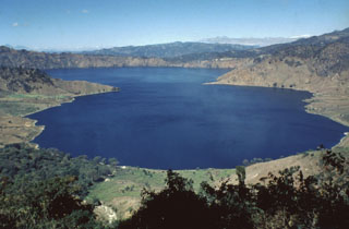 Ayarza, a scenic double caldera filled by Laguna de Ayarza, is seen here from the ESE. The peninsulas of Punta el Picacho (left) and Punta el Picachito (right) lie across an 800-m-wide channel separating the two halves of the 5 x 7 km wide, figure-8-shaped caldera. Both calderas, whose steep walls rise nearly 600 m above the lake surface, were formed within several thousand years of each other during major rhyolitic explosive eruptions in the late Pleistocene between about 27,000 and 23,100 years ago.
 Photo by Bill Rose, 1980 (Michigan Technological University).
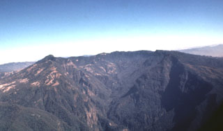
 The deep valley cutting across the center of the photo is the elongated breached caldera of Siete Orejas volcano. It is seen here from the SE from near the summit of Santa María volcano. Light-colored areas on the caldera rim are voluminous rhyodacitic pumice deposits from Siete Orejas. Tacaná volcano on the México/Guatemala border is on the left-center horizon, and Tajumulco is visible to its right. These are the two highest volcanoes of Guatemala.
Photo by Bill Rose, 1972 (Michigan Technological University).
 The NE flanks of the broad Siete Orejas massif rise above farmlands on the banks of the Sigüilá river. A large caldera is breached to the south, on the opposite side of the volcano. The volcano overlooks Quetzaltenango, Guatemala's second largest city, which is out of view to the left. The broad irregular summit profile gives the volcano its name, which means "Seven Ears." The latest eruption of Siete Orejas is stratigraphically constrained to have occurred between about 126,000 and 85,000 years ago.
 Photo by Bill Rose, 1974 (Michigan Technological University).
 Massive airfall pumice deposits blanket the countryside around Siete Orejas volcano. The coarse white rhyodacitic pumice creates the impression of snowfall over broad areas, and on the volcano itself the mantle is so thick that underlying lavas are rarely exposed. Eruption of the airfall pumice was followed by the production of massive pumiceous pyroclastic flows that filled the valley of Quetzaltenango to depths up to about 75 m.
Photo by Bill Rose, 1981 (Michigan Technological University).
 The massive breached caldera of Siete Orejas volcano is seen here from the south, the direction in which it is breached by the Ocosito river. Irregularities on the broad rim of the 3.5 x 10 km caldera give the volcano its name, which means "Seven Ears."
 Photo by Bill Rose, 1980 (Michigan Technological University).
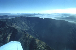 The southern side of Siete Orejas volcano is cut by a large breached caldera drained by the Ocosito river. The caldera, seen here from the SW, is 3.5 km wide and more than 10 km long, and its walls tower about 1000 m above the caldera floor. The origin of the caldera is uncertain, but may involve one or more processes including collapse following a major explosive eruption, collapse by slope failure, and excavation by headward stream erosion.
Photo by Bill Rose, 1980 (Michigan Technological University).
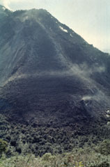
 The front of the 1972 lava flow ends on grassy slopes on the southern flank of MacKenney cone at Pacaya. The rock hammer to the upper right provides scale next to the top of the flow front that formed when still-fluid lava was squeezed through an irregular crack in previously solidified crust.
Photo by Bill Rose, 1972 (Michigan Technological University).
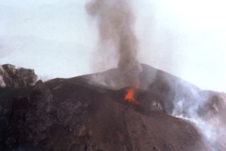
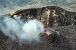 Incandescent lava spatter is ejected from a small cone in MacKenney crater in February 1981. Lava flows from the cone filled the crater floor and flowed out through a notch in the crater rim.
Photo by Bill Rose, 1981 (Michigan Technological University).
 The Volcán de Pacaya massif rises above the capital city of Guatemala, located only 30 km to the north. The rounded, forested lava dome of Cerro Grande forms the high point at the left. The next highest peak to the right is the historically active vent of Pacaya, with the right-hand summit being the MacKenney cone, which has been active since 1965. Eruptions of Pacaya are often visible from Guatemala City.
Photo by Bill Rose, 1989 (Michigan Technological University).
 In May 1981 lava flows overtopped a notch in the NW rim of MacKenney crater and flowed down the northern flank. This view from Meseta on the caldera rim shows multiple individual flow lobes with levees. The dark lava field to the right contrasts with the tephra-covered slopes of the cone to the left. This period of frequent lava extrusion lasted from 9 May until 2 June.
Photo by Bill Rose, 1981 (Michigan Technological University).
 This lava flow surface were formed when still-fluid lava was squeezed through an irregular crack in previously solidified crust. Note the rock hammer at the right-center for scale. Frequent lava extrusion has occurred at Pacaya since 1965.
Photo by Bill Rose, 1978 (Michigan Technological University).
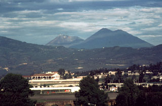
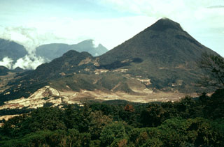
 This view from the east shows four major volcanoes located within 45 km of Guatemala City. In the foreground is Pacaya, which has been in frequent eruption since 1965. The modern cone (left) partially overlaps the rim of a large caldera. The large volcano in the midground horizon is Volcán de Agua. In the background is Acatenango (right) and Fuego (left).
 Photo by Bill Rose, 1991 (Michigan Technological University).
 In February 1972 a lava flow from vents at the base of MacKenney cone at Pacaya descended the western flanks and covered farmlands on the caldera floor. The flow was diverted around topographic irregularities, forming several large kipukas. Lava effusion began on 2 February and lasted until the 27th. This December 1972 photo was taken from the summit of MacKenney cone with a village to the upper right
 Photo by Bill Rose, 1972 (Michigan Technological University).
 The Pacaya MacKenney crater contains spatter cones that have produced lava flows, and gas plumes like the one seen here. This photo taken in May 1981 shows the broad several-hundred-meter wide crater rim. From 9 May to 2 June lava flows from the spatter cones covered the crater floor and flowed through notch in the NW crater rim. In the background are Fuego and Acatenango (right-center) and Volcán de Agua (right).
 Photo by Bill Rose, 1981 (Michigan Technological University).
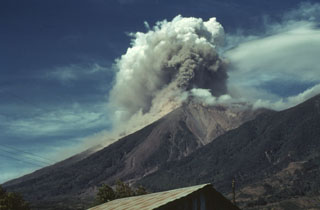
 Winds deflect a small 27 February 1978 ash plume from the Fuego summit crater to the west. In the background is Acatenango, which rises about 700 m above the saddle between it and Fuego. Intermittent minor eruptions took place from 11 September 1977 to 8 August 1979, sometimes producing pyroclastic flows and lava flows.
Photo by Bill Rose, 1978 (Michigan Technological University).
 A pyroclastic flow descends drainages on the east flank of Fuego in October 1975 as an ash plume (right) towers above the summit. Intermittent minor eruptions took place 28 May, 23 July to 4 August, and 19 September to 21 October 1975. On 11-12 and 16 October ash fell in, and west of, Antigua. This photo was taken from Finca Capetillo, near Alotenango. Pyroclastic flows frequently travel down these same drainages and had occurred during the two previous eruptions in 1973 and 1974.
 Photo by Bill Rose, 1975 (Michigan Technological University).
 A small lahar travels down the Barranca Honda valley on the eastern side of Fuego during the February-March 1973 eruption. The channel was also affected by pyroclastic flows during the relatively moderate 1972 eruption.
Photo by Bill Rose, 1973 (Michigan Technological University).
 Fuego and Acatenango volcanoes tower more than 3.5 km above farmlands of the Pacific coastal plain. Edifice failure of these volcanoes has occurred in the direction of the coastal plain, producing major debris avalanches that reached as far as 50 km away.
Photo by Bill Rose, 1970 (Michigan Technological University).
 Acatenango (right) is seen here with Fuego at the center in 1986. Volcán Acatenango was constructed during three eruptive periods post-dating the roughly 84,000-year-old Los Chocoyos Ash from Atitlán caldera. The eruptive period of Yepocapa, the northern peak of Acatenango, ceased about 20,000 years ago. The eruption of the southern and highest cone, Pico Mayor began at that time.
Photo by Bill Rose, 1986 (Michigan Technological University).
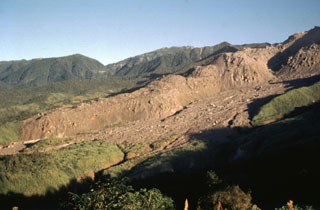
 Hummocks of the Escuintla debris avalanche deposit, most likely from the Fuego-Acatenango massif, cover the Pacific coastal plain of Guatemala about 30 km from their source. This massive volcanic landslide is the largest known in Guatemala. The avalanche traveled about 50 km from the Fuego-Acatenango massif and covered about 420 km2, with an estimated volume of about 15 km3.
Photo by Bill Rose, 1988 (Michigan Technological University).
 A small ash plume from the summit of Fuego on 27 February 1978 is deflected to the south as a second plume rises from another vent immediately to the left. Volcán de Agua is in the distance. Fuego erupted intermittently from September 1977 to August 1979.
Photo by Bill Rose, 1978 (Michigan Technological University).
 Prevailing winds disperse an ash plume from Fuego to the SW in December 1978 as a small pyroclastic flow descends the SE (left) flank. Intermittent minor eruptions took place over a two-year interval from 11 September 1977 to 8 August 1979. Strombolian eruptions were sometimes accompanied by small pyroclastic flows and lava flows.
Photo by Bill Rose, 1978 (Michigan Technological University).
 Two ash plumes rise simultaneously from small vents in the Fuego summit crater on 27 February 1978. This view is from the NE with the Pacific coastal plain in the background. Intermittent minor eruptions took place from 11 September 1977 to 8 August 1979. Strombolian eruptions from vents in the crater formed small cones and produced incandescent fountains at night.
Photo by Bill Rose, 1978 (Michigan Technological University).
 An aerial view of the Fuego summit crater in 1990 shows the products of both effusive and explosive eruptions. The crater walls expose light-colored lava flows and lava agglutinate as well as darker scoria deposits. Historical eruptions have been basaltic in composition, continuing a trend towards more mafic in the Acatenango-Fuego volcanic complex. An Acatenango flank is to the left in this view from the SW.
Photo by Bill Rose, 1990 (Michigan Technological University).
 Two vents in the Fuego summit crater were active simultaneously at the time of this 24 February 1978 aerial photograph. A small ash plume rises above the vent at the far side of the crater, while the vent in the foreground ejects lava spatter. This vent feeds a degassing and faintly incandescent lava flow that can be seen to the lower right.
Photo by Bill Rose, 1978 (Michigan Technological University).
 The flanks of Fuego are seen here in an aerial view from the SE in 1978 with Acatenango to the right. Over the formation of these volcanoes the activity began at the northern center, farthest away from the Central American trench (100 km S), and subsequently migrated to the south.
Photo by Bill Rose, 1978 (Michigan Technological University).
 Frequent explosive eruptions have kept the summit of Fuego unvegetated. Historical lava flows that originated from the summit crater descended through forests down the Río Taniluya (left) and the Río Ceniza (right) on the SW flank. Acatenango is to the left.
Photo by Bill Rose, 1980 (Michigan Technological University).
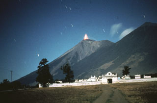 A time exposure taken in 1978 from the NE shows incandescent lava ejected at the summit of Fuego. Intermittent minor eruptions took place from 11 September 1977 to 8 August 1979, sometimes producing pyroclastic flows and lava flows.
Photo by Bill Rose, 1978 (Michigan Technological University).
 This elongate crater is along the northern flank of Pico Mayor, the summit of Acatenango. The first well-documented eruption of Acatenango took place from this N-flank vent beginning 18 December 1924. The eruption continued until 7 June 1925. On 14 March 1925 ash fell as far away as Pochuta.
Photo by Bill Rose, 1980 (Michigan Technological University).
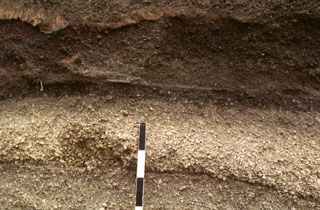 A tephra layer from Acatenango is exposed NE of the volcano along the road between Antigua and Yepocapa. Pottery fragments within the tephra layer were dated between 1,400 and 1,500 CE. Most Holocene eruptions from Acatenango originated from Pico Mayor, the southernmost and highest of the two peaks. The scale bar marks 10 cm intervals.
Photo by Bill Rose, 1978 (Michigan Technological University).
 A thick sequence of tephra layers, mostly from Acatenango, is exposed on the northern flank. Yepocapa, the northernmost of the two volcanic centers forming Acatenango, formed between about 70,000 and 43,000 years ago. Its major period of eruptive activity ended about 20,000 years ago, after which the activity of the southernmost center, Pico Mayor, commenced.
Photo by Bill Rose, 1987 (Michigan Technological University).
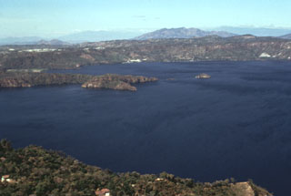
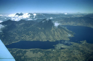
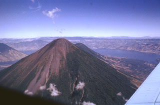
 Tolimán volcano is 4 km away beyond the summit of Atitlán. Atitlán was constructed over the approximate rim of the Atitlán III caldera, whereas Tolimán was built over the margin of Atitlán II caldera. The irregular Lake Atitlán shoreline to the left is formed by lava flows from Tolimán. The far Atitlán III caldera rim can be faintly seen across the lake. The two post-caldera cones have dramatically different eruptive styles, with lava flows dominating at Tolimán and pyroclastic eruptions at Atitlán.
 Photo by Bill Rose, 1983 (Michigan Technological University).
 Volcán San Pedro (center) occupies the SW corner of the roughly 85,000-year-old Atitlán III caldera. San Pedro is seen here across narrow Santiago Bay from the lower slopes of Atitlán and Tolimán volcanoes. The 3020-m-high San Pedro has a shallow summit crater that is breached to the NW. The age of the most recent activity of San Pedro is unknown, although the volcano is more vegetated and erosionally modified than the twin volcanoes of Tolimán and Atitlán and is clearly the oldest of the three post-caldera volcanoes.
Photo by Bill Rose, 1980 (Michigan Technological University).
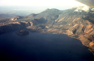
 Lobate lava flows from Tolimán volcano form the irregular shore jutting into Lake Atitlán. The Cerro de Oro cone is on the near shore to the upper right, and the NE wall of Atitlán caldera rises about 1 km above the far side of the lake. The town of Santiago Atitlán (foreground) lies near the mouth of Santiago Bay. The buried margin of Atitlán I caldera, the first of three Miocene-Pleistocene calderas at Atitlán, lies approximately below Cerro de Oro; the boundary of Atitlán II caldera lies just below the bottom of the photo.
Photo by Bill Rose, 1980 (Michigan Technological University).
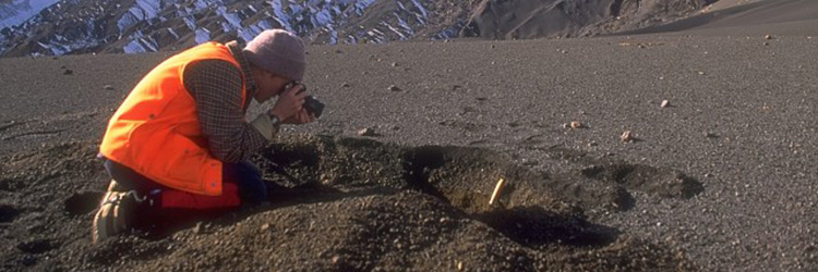
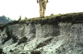
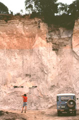 A geologist examines an outcrop of the 84,000-year-old Los Chocoyos Ash near Patzún, about 10 km E of Lake Atitlán. Note the charred log above his head. This pyroclastic flow unit of the Los Chocoyos deposit is up to 200 m thick and is exposed over an area of about 2,000 km2. Individual flow units of the voluminous ignimbrite are sometimes more than 100 m thick. The upper part of the deposit is characteristically salmon-pink in color as a result of oxidation of the cooling flow.
Photo by Bill Rose, 1980 (Michigan Technological University).
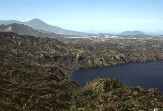
 Santiago Bay in Lake Atitlán is the result of encroachment by the flanks of three post-caldera volcanoes into the lake. The narrow channel extends about 8 km to the low southern caldera wall and is about 1 km wide. To the right are the San Pedro flanks, the oldest of the post-caldera stratovolcanoes. Contrasting eruptive styles produced the irregular shoreline in the left foreground consisting of lava flows from Tolimán and the smoother shoreline to the right, formed by pyroclastic deposits from Atitlán.
Photo by Bill Rose, 1980 (Michigan Technological University).
 Cerro de Oro is a lava dome that was constructed on the northern flank of Tolimán, near the southern shoreline of Lake Atitlán. Lava flows from Cerro de Oro extend into the lake and may be as young as a few thousand years. The dome's name (which means Hill of Gold) reflects local belief that it contains buried treasure.
Photo by Bill Rose, 1972 (Michigan Technological University).
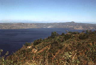
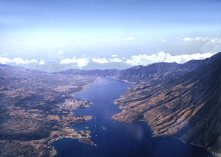
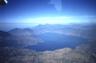
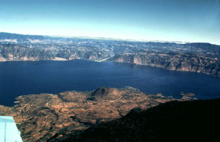 Lake Atitlán fills the northern half of the Atitlán III caldera, which formed about 84,000 years ago following eruption of the Los Chocoyos Ash. The 18-km-long caldera lake is seen here from the south, with the flanks of the post-caldera Tolimán volcano in the foreground. The relatively flat lake floor is 300 m below the water surface, and caldera walls rise to about 1 km above the lake.
 Photo by Bill Rose, 1980 (Michigan Technological University).
 Volcán Atitlán directly overlies the inferred margin of the Pleistocene Atitlán III caldera, whose northern rim lies across Lake Atitlán. The Atitlán stratovolcano is adjacent to Tolimán to its north (seen just to the right of Atitlán's summit). The historically active Atitlán is younger than Tolimán, although their earlier activity overlapped. Atitlán’s surface is composed of tephra, reflecting its predominantly explosive eruptions that have been recorded since the 15th century.
Photo by Bill Rose, 1980 (Michigan Technological University).
 Volcán Tolimán (center) towers above the south shore of scenic Lake Atitlán. Tolimán and the adjacent Atitlán (upper left) were constructed within the Pleistocene Atitlán III caldera, near its inferred southern margin. In contrast to the tephra-covered surface of Volcán Atitlán, the surface of Tolimán is dominated by thick lava flows. The recent eruptions of Tolimán were primarily effusive eruptions from flank vents. The resulting lava flows extend into the lake and produce the irregular shoreline.
Photo by Bill Rose, 1972 (Michigan Technological University).
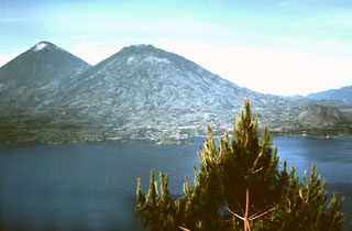
 The summit of Atitlán volcano contains shallow craters in this 1980 photo. San Pedro volcano rises across Santiago bay to the right, and in the distance (left-to-right) are the peaks of Santo Tomás, Santa María, and Tajumulco. Atitlán is the highest of the three post-caldera cones of Atitlán caldera.
Photo by Bill Rose, 1980 (Michigan Technological University).
 The rounded peak in the foreground is Tolimán volcano. The older post-caldera San Pedro volcano is across Santiago Bay to the right. In the distance are the peaks of Santo Tomás (left) and Santa María (right). Tajumulco volcano is the peak on the far-right horizon. The Guatemalan volcanic front rises more than 3,500 m above the hazy Pacific coastal plain to the upper left.
Photo by Bill Rose, 1980 (Michigan Technological University).
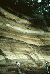
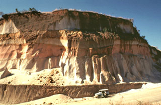
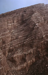
 The 84,000-year-old Los Chocoyos Ash from Atitlán caldera is exposed in a quarry near San Juan Ostuncalco, west of Quetzaltenango. The white layer at the base is layer H, a rhyolite unit that is one of the largest known Plinian fall deposits in Central America. Despite its relative thinness, it is preserved over the entire Guatemalan highlands. The thicker overlying unit is the pyroclastic flow deposit, part of the Los Chocoyos ash. This massive unwelded pyroclastic flow deposit is up to 200 m thick.
Photo by Bill Rose, 1974 (Michigan Technological University).
 Volcán San Pedro (upper right) is the oldest of three stratovolcanoes constructed within Atitlán caldera. The furrowed slopes of the volcano contrast with the less eroded flanks of the both Atitlán and Tolimán volcanoes. Cerro de Oro, the small lava dome just beyond the shore of Lake Atitlán to the left, is a flank dome of Tolimán. Young lava flows from Tolimán descend into the lake and form part of its southern shore in this view from the west.
Photo by Bill Rose, 1978 (Michigan Technological University).
 Three stratovolcanoes fill the southern half of Atitlán caldera in this view from the NE. Atitlán caldera formed during three major explosive eruptions from the Miocene to late Pleistocene. Atitlán volcano (far left) was constructed above the southern rim of the youngest caldera, Atitlán III, whose low southern rim is visible on the center horizon beyond narrow Santiago bay. Tolimán (right of Atitlán) and San Pedro (far right) overlie the rim of Atitlán II. The buried rim of Atitlán I lies below the shoreline of Tolimán.
Photo by Bill Rose, 1980 (Michigan Technological University).
 A panoramic view to the west across Lake Atitlán shows the flanks of Tolimán volcano extending to the lakeshore on the left, San Pedro volcano at the SW end of the lake, and the two peaks of Santo Tomás (left) and Santa María (right) on the center horizon. Tajumulco volcano appears in the distance at the upper right. Lake Atitlán occupies the northern half of the youngest Atitlán caldera, which formed during the eruption of the Los Chocoyos Ash about 84,000 years ago.
Photo by Bill Rose, 1972 (Michigan Technological University).
 Thick units of the 84,000-year-old Los Chocoyos Ash are exposed south of Guatemala City, more than 100 km from its source at Atitlán caldera. Three units are visible here. The pinkish unit across the center of is the oxidized top of the pyroclastic flow deposit. The bottom two white units are the top and bottom halves of the deposit. The two fall deposits above the Los Chocoyos Ash are unit E from Amatitlán caldera and the younger unit C from Volcán de Agua.
Photo by Bill Rose, 1978 (Michigan Technological University).
 This view looks to the south from near the summit of Volcán de Zunil towards Volcán Santo Tomás. Geothermal fields are located along the ridge between Santo Tomás and Zunil.
 Photo by Bill Rose, 1977(Michigan Technological University).
 Volcán Santo Tomás is a large eroded stratovolcano seen here to the east across the valley of the Río Samalá from the Zunil geothermal site. The summit of Volcán de Zunil is 4.5 km to the NE. Geothermal fields are located on the NW Santo Tomás flank and 3 km north along the ridge to the Zunil summit.
Photo by Bill Rose, 1981 (Michigan Technological University).
 The rock around the Almolonga volcano Zunil geothermal field on the SE flank of Cerro Quemado volcano is extensively hydrothermally altered. The geothermal area is located along the Zunil fault zone, which juxtaposes brownish-red weathered to lightly altered andesite to dacite lava flows with white-to-pink heavily altered and brecciated volcanic rock. Hydrothermal alteration minerals include kaolinite, pyrite, gypsum, and alunite. The NE-SW-trending left-lateral fault zone runs parallel to the valley of the Río Samalá.
Photo by Bill Rose, 1981 (Michigan Technological University).
 The Almolonga volcano Zunil geothermal project is seen here in 1981, a decade prior to a landslide that buried the well site. Well ZCQ-4 was drilled in 1981 to a depth of about 1.3 km and cemented to a depth of 400 m. In October 1989 the recorded bottom hole temperature was 260°C. The upper part of the geothermal system contains acid-sulfate hot springs. Associated mud pools and fumaroles occur at high points on both sides of the Río Samalá, and bicarbonate-rich hot springs discharge into the river's canyon.
Photo by Bill Rose, 1981 (Michigan Technological University).
 Lava spines are seen here along the summit ridge of Cerro Quemado, the youngest of a series of lava domes erupted along the margins of Almolonga volcano. The early stages of the Cerro Quemado complex eruptions produced a sequence of lava flows and domes erupted from at least eight vents. During the later stages about 1,150 years ago the summit dome of Cerro Quemado was emplaced following failure of the summit area. An eruption took place from an E-flank vent in 1818.
Photo by Bill Rose, 1972 (Michigan Technological University).
 Collapse of the NE flank of the Almolonga Cerro Quemado lava dome about 1,150 years ago produced a debris avalanche deposit with the hummocky terrain in the foreground. An associated lateral blast also swept across the Llano del Pinal, the plain in the foreground. The eruption concluded with the emplacement of a small lava dome inside the avalanche scarp.
Photo by Bill Rose, 1989 (Michigan Technological University).
 The Cerro Quemado lava dome (left), seen here from Siete Orejas volcano, is one of a series of lava domes along the margin of the Almolonga caldera. The Cerro Quemado dome complex formed during the Holocene from eruptions along at least eight vents. One of these domes forms the low rounded feature below the center horizon. Santa María lies just out of view to the right, and the western side of the Santo Tomás volcanic complex forms the horizon.
Photo by Bill Rose, 1975 (Michigan Technological University).
 The line of low-elevation forested lava domes in the center of the photo are a chain of domes erupted along the rim of a Pleistocene caldera of the Almolonga complex. The highest dome, Cerro Quemado, is the peak seen here from the north below and to the left of Santa María, the highest peak in this photo. A 3.3-km-wide caldera formed within the field sometime prior to 85,000 years ago. Post-caldera eruptions produced eight lava domes.
Photo by Bill Rose, 1973 (Michigan Technological University).
 The four major domes of the Santiaguito complex are seen here from the summit of Santa María in 1980. Caliente is degassing to the left, with La Mitad and El Monje in the center, and El Brujo to the right. The dacite dome complex stretches about 3 km in a roughly E-W direction. Lava flows and lahar channels extend down drainages from the dome complex to the south.
Photo by Bill Rose, 1980 (Michigan Technological University).
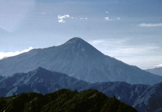
 The Santa María western flank of is seen here at sunset. The light-colored area to the upper right is the upper headwall of the 1902 explosion crater across the SW flank. Pumice deposits from the 1902 eruption are visible across the flanks, exceeding 15 m in thickness.
Photo by Bill Rose, 1970 (Michigan Technological University).
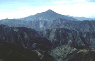
 Santa Maria is seen here from Siete Orejas volcano. The SW (right-hand) flank of Santa María is slightly influenced by the profile of the massive crater produced by the 1902 eruption. The forested peak on the lower NE flank of Santa María is Volcán del Valle, an eroded scoria cone. Behind it is Santo Tomás volcano. Light-colored pumice deposits from the 1902 Santa María eruption and a Pleistocene eruption of Siete Orejas volcano are visible in the foreground.
Photo by Bill Rose, 1975 (Michigan Technological University).
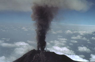
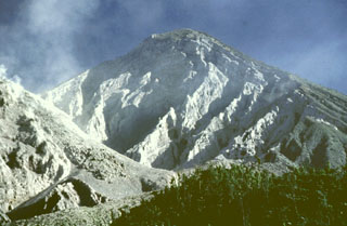
 An ash plume rises above the Santiaguito lava dome complex in June 1976 nearly to the height of Santa María's summit. The dome complex was constructed within a large explosion crater that formed in the SW flank of during the major 1902 explosive eruption. The crater, seen in profile here, extends from just below the summit to 2.2 km elevation, below the bottom of the photo.
Photo by Bill Rose, 1976 (Michigan Technological University).
 An aerial view of the Río Las Majadas valley in Guatemala on the NNE side of Tacaná volcano shows thick deposits of lahars and debris avalanches filling the valley. These deposits provide a flat surface for agricultural use in deeply eroded terrain. The valley drains from its headwaters in Guatemala through México into the Pacific Ocean, and lahars during future eruptions could affect both countries.
Photo by Bill Rose, 1986 (Michigan Technological University).
 The thick unvegetated lava flow descending diagonally across the photo originated from El Brujo (upper right) at the western end of the Santiaguito lava dome complex. This north-looking 1970 view shows Santiaguito's SW-flank topography prior to a period of rapid lava extrusion from El Brujo during 1972-75. The flanks of Siete Orejas volcano form the horizon.
Photo by Bill Rose, 1970 (Michigan Technological University).
 This lava flow descended the northern flank of El Brujo on Santiaguito. El Brujo, seen here from the La Loma trail, is the westernmost of the Santiaguito lava dome complex that began erupting in the late 1950s.
Photo by Bill Rose, 1972 (Michigan Technological University).
 This tall feature is a collapse remnant of a lava flow extruded from the Caliente vent on the eastern side of Santiaguito lava dome between January 1972 and May 1973. A period of increased lava effusion between 1972 and 1975 was unusual because large flows originated from vents at both ends of the dome complex.
Photo by Bill Rose, 1978 (Michigan Technological University).
 Santa María is one of Guatemala's most active volcanoes. Growth of the degassing Santiaguito lava dome complex began in 1922 at the base of the large crater formed in the Santa María SW flank during a major explosive eruption in 1902. Light-colored volcanic deposits fill the moat to the left of the dome. Lava flows accompanying dome growth descend towards the lower right. The lower peak behind and to the left of Santa María is Cerro Quemado, a lava dome complex within the Almolonga caldera.
Photo by Bill Rose, 1980 (Michigan Technological University).
 Santa María is one of the most active volcanoes in Guatemala. Its morphology changed drastically in 1902 when a catastrophic eruption formed a 1-km-wide crater. The large Santiaguito lava-dome complex (center) has been growing at the base of the 1902 crater since 1922. Lava flows can be seen down the flank. Dome growth is accompanied by frequent minor explosions, along with periodic lava extrusion, larger explosions, pyroclastic flows, and lahars.
Photo by Bill Rose, 1980 (Michigan Technological University).
 An aerial view from the SE shows the Santiaguito lava dome complex at the base of the 1.5-km-wide 1902 crater on the SW flank of Santa María. Lava flows from the Caliente dome at the eastern side of Santiaguito descend to the bottom center of the photo; lava flows from the western El Brujo vent are visible at the lower left. The broad volcano to the upper left is Siete Orejas.
 Photo by Bill Rose, 1980 (Michigan Technological University).
 Deposits of the 1902 Plinian eruption are exposed in a 1-m-thick outcrop 3.2 km S of Llano del Pinal, the saddle between Santa María and Siete Orejas volcanoes. The pumice is overlain by about 15 cm of finer-grained darker-colored ash. Most of the outcrop consists of light-colored dacite pumice fragments. Pumice fall was reported in Tapachula across the Mexican border, and ashfall was reported in Mexico City.
Photo by Bill Rose, 1967 (Michigan Technological University).
 The steep walls of the 1902 explosion crater at Santa María expose a sequence of alternating thin (1-10 m) light-colored lava flows and brownish-colored block-and-ash flow deposits. Growth of the cone involved the extrusion of lava flows, mostly from the summit vent.
 Photo by Bill Rose, 1974 (Michigan Technological University).
 The eroded headwall of the 1.5-km-wide 1902 crater extends from just below the summit down to 2.2 km elevation, where a volume of 0.5 km3 was removed during the eruption. The Santiaguito lava dome complex (left) began growing in the new crater in 1922. This 1991 view shows a lava flow descending the right flank of the dome.
Photo by Bill Rose, 1991 (Michigan Technological University).
 Tajumulco's southern flanks (left), which descend toward the Pacific coastal plain, are steeper than its northern flanks. At its base are exposed plutonic rocks.
Photo by Bill Rose, 1986 (Michigan Technological University).
 Tajumulco is seen here from the NNW. It rises above deeply eroded valleys within plutonic and Tertiary volcanic rocks. Prior to this 1986 photo there had been several unconfirmed reports of eruptions.
Photo by Bill Rose, 1986 (Michigan Technological University).
 The NE side of Tajumulco volcano has gentler slopes and more extensive agricultural use than the NW side. Tajumulco lies NW of the main tourist areas in the Central Highlands and is infrequently visited. The volcano is located closer to Tacaná volcano on the México/Guatemala border than it is to other Guatemalan volcanoes.
Photo by Bill Rose, 1986 (Michigan Technological University).
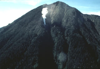 An aerial view of the NE flank of Tacaná volcano on 25 June 1986 shows a steam plume rising above a new vent. Minor phreatic eruptions, the first since 1949, took place in February, May, and June 1986. Following a seismic swarm beginning the previous day, a moderate phreatic explosion around noon on 8 May created a new 10-m-wide vent and ejected a small amount of fine ash. Vegetation was damaged over an area of 200 x 100 m.
Photo by Bill Rose, 1986 (Michigan Technological University).
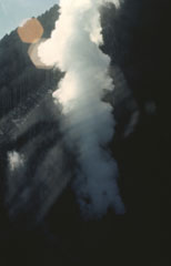 Minor phreatic eruptions took place at Tacaná in February, May, and June 1986. Following a seismic swarm that began the previous day, a moderate phreatic explosion around noon on 8 May created a new 10-m-wide vent and ejected a small amount of fine ash. Vegetation was damaged over an area of 200 x 100 m. Vigorous steam emission was continuing at the time of this 25 June photo. The new vent formed at about 3,600 m elevation on the NE flank.
 Photo by Bill Rose, 1986 (Michigan Technological University).
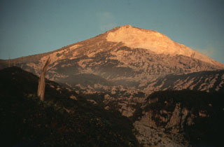
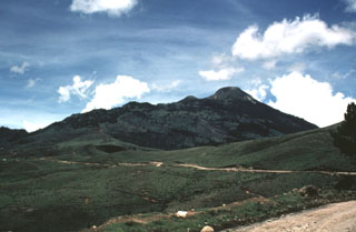
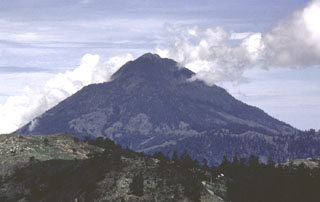 Tacaná is located on the México/Guatemala border at the far NW end of the Central American volcanic belt. It is seen here from the Guatemalan side of the border to the ENE, where it rises steeply above a 9-km-wide caldera surrounded by deeply eroded plutonic rocks. Historical activity has included mild phreatic eruptions, but stronger explosive activity and production of pyroclastic flows occurred earlier.
Photo by Bill Rose, 1986 (Michigan Technological University).
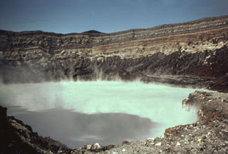
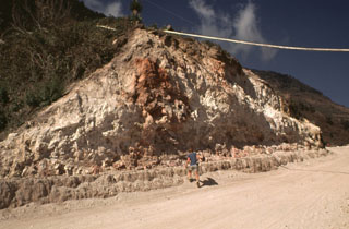
 A volcanologist traverses the floor of the El Chichón crater toward the steaming, turquoise crater lake in January 1983, during the first visit to the crater following the major March-April 1982 explosive eruption. The new lake had grown to a depth of about 120 m by November 1982, after which lake level dropped slightly. In January 1983 the lake was hot (52-58°C) and acidic (pH of 0.5). By October 1983 the temperature had dropped to 42°C and the pH was 1.8.
 Photo by Bill Rose, 1983 (Michigan Technological University).
 The eastern rim of the 1982 crater at El Chichón is seen here from the rim of the larger, older crater. Erosional gullies formed within pyroclastic flow and surge deposits that traveled radially away from the 1982 crater. The rim rises about 50 m above the moat between the two craters. Prior to the 1982 eruption a lava dome reached several hundred meters above the crater floor.
Photo by Bill Rose, 1983 (Michigan Technological University).
 The new 1-km-wide El Chichón crater is seen here in January 1983, less than a year after the major explosive eruption . By this time it was partially filled by a hot, acidic lake. The isolated, low-profile, volcano is a small lava dome complex that was heavily vegetated prior to 1982. More than a half-dozen large explosive eruptions have occurred since the mid-Holocene.
Photo by Bill Rose, 1983 (Michigan Technological University).
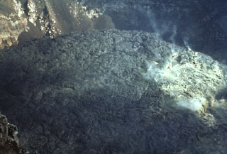
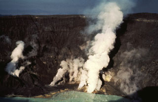 Gas-and-steam plumes emit from fumaroles on the crater floor of El Chichón volcano in January 1983. Gas and steam also rise from the hot, acidic crater lake in the foreground. Fumarole temperatures in the lower crater walls and floor ranged from 98 to 115°C.
Photo by Bill Rose, 1983 (Michigan Technological University).
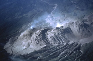
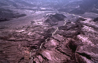 Devastating pyroclastic flows and surges from the March-April 1982 eruptions of El Chichón turned large areas surrounding the crater into a landscape devoid of vegetation. The pyroclastic flows and surges travelled radially away from the volcano to distances of about 6 km, covering an area of about 153 km2. This January 1983 aerial photo shows the effect of extensive erosion of these deposits during the previous rainy season.
Photo by Bill Rose, 1983 (Michigan Technological University).
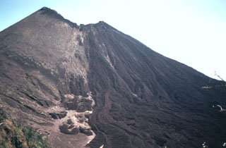
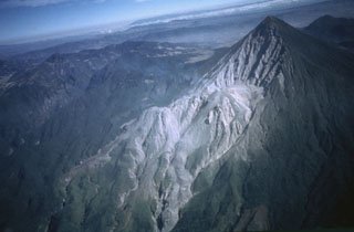
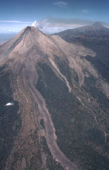 This 3.5-km-long lava flow was emplaced in 1975-76 at Colima. The flow split into two lobes on the upper flank; a shorter lobe drops diagonally to the right just below the light-colored barranca wall (center). Another flow during this eruption traveled down the NE flank and diverged around El Volcancito, the lava dome forming the ridge on the NE (right-hand) flank. A plume drifts to the NE toward the summit of Nevado de Colima.
Photo by Bill Rose, 1989 (Michigan Technological University).
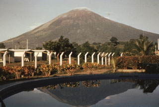
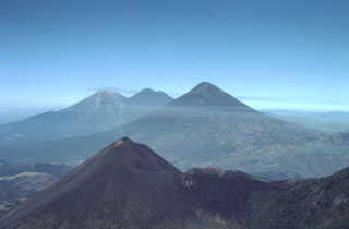
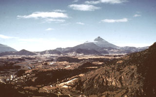
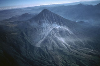
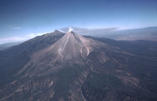 A diffuse gas plume emits from the summit of Colima with a rate of 320 ± 50 tons/day in February 1982. Volcanism at the Colima volcanic complex has migrated southward from the 300-500 km3 Nevado de Colima in the background. The ancestral Colima volcano was constructed on the southern flank of Nevado de Colima and then collapsed to form the scarp, which now holds the modern Colima edifice (foreground) that grew over the past 2,600 years.
Photo by Bill Rose, 1982 (Michigan Technological University).
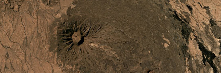
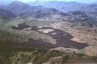
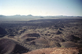 More than 500 basaltic scoria cones and associated lava flows dot the Pinacate volcanic field, visible here near Cerro Colorado. The field also contains maars like Cerro Colorado and the large basaltic-to-trachytic Santa Clara shield volcano.
Photo by Bill Rose, 1997 (Michigan Technological University).
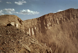
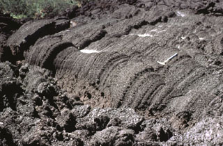
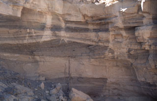 Pyroclastic surge deposits exposed in gullies on the flanks of Cráter Elegante in the Pinacate volcanic field of NW México. This photo shows cross bedding produced by particles transported by saltation or dilute suspension in a high-velocity pyroclastic surge. The direction of movement of the surge cloud, seen by the truncation of dune beds on the near-vent side, was from right to left. This type of bedding is common in areas near the rim of the maar.
Photo by Bill Rose, 1997 (Michigan Technological University).
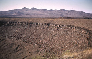 Santa Clara shield volcano, seen on the SW horizon beyond the rim of Cráter Elegante maar, is of late-Pliocene to Pleistocene age. The broad edifice is largely mantled by pyroclastic ejecta and lava flows of the basaltic Pinacate monogenetic volcanic series, which began erupting about 1.2 million years ago. More than 500 scoria cones and associated lava flows have formed across the Pinacate field and extend into the surrounding desert.
Photo by Bill Rose, 1969 (Michigan Technological University).
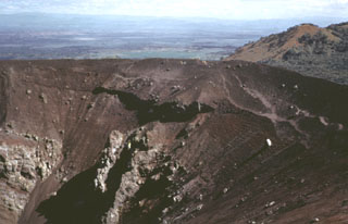 Volcán Tecolote is one of the youngest scoria cones of the Pinacate volcanic field and is located NE of Cráter Elegante. This complex cone contains faults and small craters, opens towards the NW, and was constructed on top of the Mayo cone. Large volcanic bombs, some with cores of older volcanic and non-volcanic rocks, are scattered across the southern and east crater rims and southern flanks. Six basaltic ‘a’a lava flows extend from the base of the cone.
Photo by Bill Rose, 1974 (Michigan Technological University).
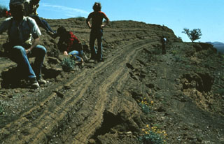 A group of geologists observe bedded pyroclastic surge deposits from the Cerro Colorado maar. Thinly bedded surge units are typical of distal portions of pyroclastic surge deposits, caused by deposition of material from the basal part of the flow.
Photo by Bill Rose, 1978 (Michigan Technological University).
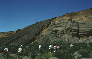 Participants in a geological field excursion examine the stratigraphy within the Cerro Colorado maar. The outcrop exposes a variety of deposits produced by several episodes of phreatomagmatic activity. The south crater walls here reveal layered tuff deposits and material from the collapse of the inner crater wall into the vent. Steeply dipping dark-colored tuff beds (left) can be traced from the crater floor up and over the walls, and then down the outer flanks of the cone.
Photo by Bill Rose, 1978 (Michigan Technological University).
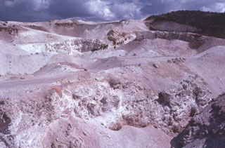 Extensive areas of hydrothermally altered rock occur at Steamboat Springs, a small volcanic field of rhyolitic lava domes and flows south of Reno, Nevada. Volcanism ranges in age from 2.53 to 1.14 million years. No eruptive activity has occurred during the Holocene, although the Steamboat Springs area contains about 50 active hot springs, numerous steam vents and fumaroles, and is an actively producing geothermal field.
 Photo by Bill Rose, 1976 (Michigan Technological University).
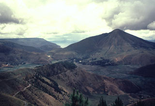 Clouds rise above the summit of Pusukbukit (right), a post-caldera cone constructed just inside the western rim of Toba caldera. Lake Toba, which fills the caldera, is visible beyond the northern (left) flank of Pusukbukit.
 Photo by Bill Rose, 1982 (Michigan Technological University).
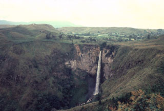 Sipisopiso waterfall, at the northern end of Lake Toba, formed on a cliff in the Middle Toba Tuff (MTT) deposit. The MTT rhyolite ignimbrite (more than 60 km3) was emplaced about 500,000 years ago during the third largest of the four major Toba caldera-forming eruptions. Products of the densely welded MTT eruption are distributed over the northern part of the caldera.
Photo by Bill Rose, 1982 (Michigan Technological University).
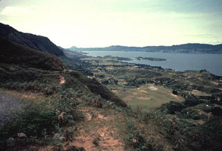 The eastern wall of the Toba caldera forms the horizon across Lake Toba from Samosir Island in the foreground. The small Tuk-Tuk peninsula (center) extends into the lake from the 630 km2 island. The small conical peak on the horizon at left-center is Tandukbenua volcano, which may have erupted only a few hundred years ago.
Photo by Bill Rose, 1982 (Michigan Technological University).
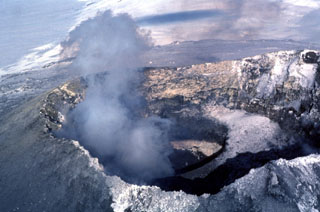 A gas plume rises above the active lava lake at the summit of Erebus in December 1983, which was first observed on 24 December 1972. Lava lake activity and intermittent Strombolian eruptions have been observed during annual scientific expeditions since then. The lava is located at the bottom of an inner 100-m-deep crater, whose snow-covered rim forms a bench at the right (SW) side of the Main Crater in this 1983 photo.
Photo by Bill Rose, 1983 (Michigan Technological University).
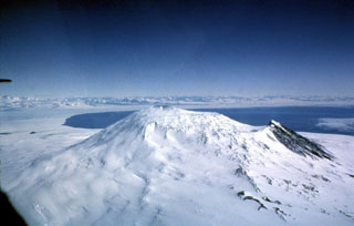 Mount Erebus is viewed here from the SE, with the water of the Ross Sea behind it and the mountains of Victoria Land in the distance. Fang Ridge is above the snow-free slope (right) on the NE flank. The plateau right of the summit is the lava flow-filled floor of the summit caldera, inside which the active summit cone was constructed. Hut Point Peninsula is the site of the McMurdo Station and is to the left of the Ross Sea.
Photo by Bill Rose, 1983 (Michigan Technological University).
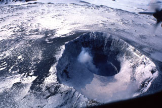 The summit of Antarctica's Mount Erebus is the world's southernmost active volcano. It contains an elliptical 500 x 600 m wide crater whose NE side contains a 250-m-wide, 100-m-deep inner crater. The flat, snow-covered floor of the Main Crater is about 100 m below its rim. A plume rises from the inner crater that has contained an active lava lake since 1972.
Photo by Bill Rose, 1983 (Michigan Technological University).
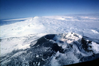 Two of the three volcanoes forming Ross Island are seen in this aerial view from the west. The Erebus summit crater that contains an active lava lake is in the foreground, with glaciated Mount Terror in the distance. Numerous scoria cones and lava domes have formed across the flanks.
Photo by Bill Rose, 1983 (Michigan Technological University).
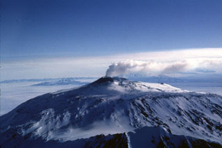 A gas-and-steam plume rises above the Mount Erebus summit crater in 1983. Fang Ridge is in the foreground of this view from the NE. The summit plateau across the center of the photo is the rim of a caldera containing the active summit cone.
Photo by Bill Rose, 1983 (Michigan Technological University).
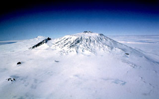 Mount Erebus is seen here from the west and is Earth's southernmost active volcano. A largely infilled caldera forms a plateau at the summit where the active cone is located. Fang Ridge is the dark area on the NE flank (left).
Photo by Bill Rose, 1983 (Michigan Technological University).
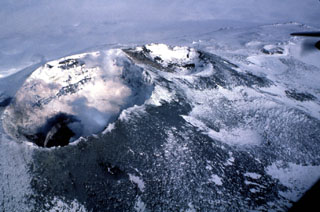 Two summit craters at Erebus are seen in this view, with the 500 x 600 m Main Crater (left) containing an active lava lake (lower left) within the Inner Crater. A smaller inactive crater (center), referred to as Side Crater, is located immediately SW of Main Crater. The smaller West Crater is to the upper right.
Photo by Bill Rose, 1983 (Michigan Technological University).
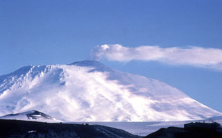 A gas plume from the Erebus summit crater casts a shadow on its western flank. There is an active lava lake in this crater and a caldera forms the plateau to the left of the summit cone. The McMurdo Station research facility on Hut Peninsula is in the foreground.
Photo by Bill Rose, 1983 (Michigan Technological University).
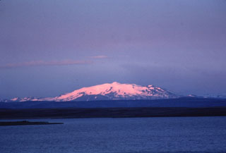 Twilight colors shade the snow-capped slopes of Hekla, one of Iceland's most active volcanoes. Hekla's elongated profile is apparent in this view from the north of the 5.5-km-long summit ridge. The Heklugjá fissure which runs along the length of the ridge has been the site of numerous historical eruptions and is often active along its full length.
Photo by Bill Rose, 1980 (Michigan Technological University).
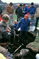 Icelandic volcanologist Sigurdur Thorarinsson (right center, with red cap) discusses ash layers exposed in an excavated pit with an international group of volcanologists on a field trip. Thorarinsson pioneered the technique of tephrochronology, and his detailed studies of tephra layers from Hekla demonstrated the value in determining the relative ages of ash layers by their stratigraphic position between dated horizons.
Photo by Bill Rose, 1980 (Michigan Technological University).
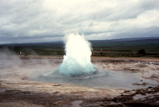 Iceland's largest geysers are located in the Haukadalur basin, part of the Geysir volcanic system, just east of the southern end of the Oddnyjarhnjukur-Langjokull fissure system. Here, the Strokkur geyser can be seen just as a burst of boiling water and steam erupts from a pool. This geyser erupts about every 10 minutes, producing a short-lived fountain that usually reaches about 20 m.
Photo by Bill Rose, 1975 (Michigan Technological University).
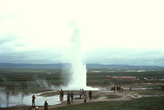 The Geysir thermal area, containing Iceland's largest geysers, lies in the Haukadalur basin, just east of the southern end of the extensive Oddnyjarhnjukur-Langjokull volcanic system. Here a geyser can be seen ejecting water and steam to about 20 m high.
Photo by Bill Rose, 1975 (Michigan Technological University).
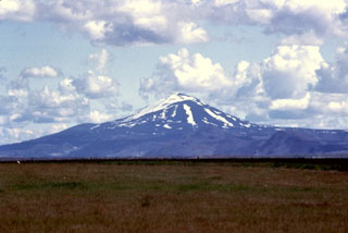 Hekla has a conical profile when viewed from the SW, looking directly down the axis of the elongated volcano. Axlargigur, the WSW end of the 5.5-km-long Heklugja fissure that crosses the summit, extends toward the photographer. This fissure was active along its entire length during the 1970 eruption.
Photo by Bill Rose, 1980 (Michigan Technological University).
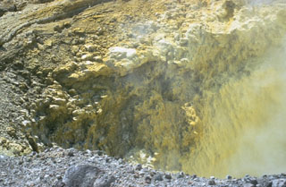 Precipitated sulfur lines the walls of a transverse fracture cutting the upper southern flank of Las Pilas volcano. The fissure extends from the upper SE flank to El Oyo pit crater on the upper SW flank. Fumaroles are particularly active at the SE end of the fissure.
Photo by Bill Rose, 1967 (Michigan Technological University).
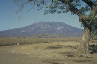 Las Pilas stratovolcano, seen here from the S, is the most prominent feature of Nicaragua's Las Pilas volcanic complex. Las Pilas rises to 900 m above its base in the Nicaraguan depression. Its broad summit contains a 700-m-wide crater and a N-S fissure that formed during an eruption in 1952.
 Photo by Bill Rose, 1967 (Michigan Technological University).
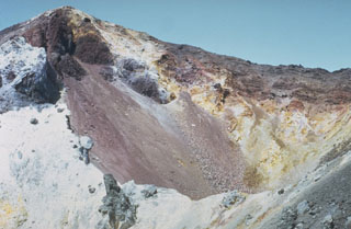 The summit crater of Cerro Negro is seen in March 1967, a year and half prior to the 1968 eruption. Light-colored areas result from heavy sublimate deposition. Frequent historical eruptions have greatly modified the morphology of Cerro Negro's summit crater.
 Photo by Bill Rose, 1967 (Michigan Technological University).
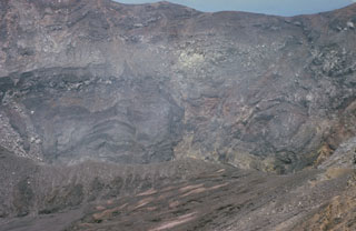 The active Santa Ana crater lies at the SE end of series of four nested summit craters and contains a small lake not visible in this photo. The northern crater wall in the background exposes a series of lava flows and inter-bedded pyroclastic deposits. Several faults are visible in the crater walls, such as the one at the upper left. Later tectonic movements produced a graben in the central part of the crater with displacements of 50-70 m.
 Photo by Bill Rose, 1966 (Michigan Technological University).
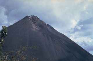 This February 1967 photo, taken from near Cerro Chino on the northern caldera rim, shows the morphology of the MacKenney crater early in the long-lived eruption that began at Pacaya in 1965. Neary continuous explosive activity with periodic lava effusion first began on 4 July 1965 from a 250-m-wide pit crater that had formed in 1962 without eruptive activity.
Photo by Bill Rose, 1967 (Michigan Technological University).
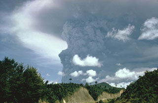 Following mild eruptions that began on 7 February 1966, a powerful eruption in April produced this ash plume that towers above the summit (not visible in this view). Major eruptions during 20 April to 1 May were accompanied by pyroclastic flows and lava flows.
Photo by Bill Rose, 1966 (Michigan Technological University).
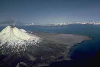 A small plume rises from the summit of glaciated Augustine in this July 1988 view from the east. The gray, unvegetated areas on the north flank are pyroclastic flow deposits from the 1986 and earlier historical eruptions. The pyroclastic flows reached the sea to the east and west. The Chigmit Mountains rise across Kamishak Bay in the distance.
Photo by Bill Rose, 1988 (Michigan Technological University).