New Zealand Volcanoes
A map display is currently under development.
New Zealand has 23 Holocene volcanoes. Note that as a scientific organization we provide these listings for informational purposes only, with no international legal or policy implications. Volcanoes will be included on this list if they are within the boundaries of a country, on a shared boundary or area, in a remote territory, or within a maritime Exclusive Economic Zone. Bolded volcanoes have erupted within the past 20 years. Suggestions and data updates are always welcome ().
| Volcano Name | Last Eruption | Volcanic Region | Primary Landform |
|---|---|---|---|
| Auckland Volcanic Field | 1446 CE | Western North Island Volcanic Province | Cluster |
| Brothers | Unknown - Unrest / Holocene | Southern Kermadec Volcanic Arc | Caldera |
| Clark | Unknown - Unrest / Holocene | Southern Kermadec Volcanic Arc | Composite |
| Curtis Island | Unknown - Unrest / Holocene | Middle Kermadec Volcanic Arc | Composite |
| Giggenbach | Unknown - Unrest / Holocene | Middle Kermadec Volcanic Arc | Composite |
| Havre Seamount | 2012 CE | Middle Kermadec Volcanic Arc | Composite |
| Healy | 1360 CE | Southern Kermadec Volcanic Arc | Composite |
| Macauley | 4360 BCE | Middle Kermadec Volcanic Arc | Caldera |
| Monowai | 2014 CE | Northern Kermadec Volcanic Arc | Composite |
| Okataina | 1981 CE | Taupo Volcanic Arc | Cluster |
| Raoul Island | 2006 CE | Northern Kermadec Volcanic Arc | Composite |
| Ruapehu | 2007 CE | Taupo Volcanic Arc | Composite |
| Rumble II West | Unknown - Unrest / Holocene | Southern Kermadec Volcanic Arc | Composite |
| Rumble III | 2008 CE | Southern Kermadec Volcanic Arc | Composite |
| Rumble IV | Unknown - Unrest / Holocene | Southern Kermadec Volcanic Arc | Composite |
| Rumble V | Unknown - Unrest / Holocene | Southern Kermadec Volcanic Arc | Composite |
| Tangaroa | Unknown - Unrest / Holocene | Southern Kermadec Volcanic Arc | Composite |
| Taranaki | 1800 CE | Western North Island Volcanic Province | Composite |
| Taupo | 260 CE | Taupo Volcanic Arc | Caldera |
| Tongariro | 2012 CE | Taupo Volcanic Arc | Composite |
| Tuhua/Mayor Island | 5055 BCE | Taupo Volcanic Arc | Shield |
| Whakaari/White Island | 2025 CE | Taupo Volcanic Arc | Composite |
| Wright | Unknown - Unrest / Holocene | Middle Kermadec Volcanic Arc | Composite |
Chronological listing of known Holocene eruptions (confirmed or uncertain) from volcanoes in New Zealand. Bolded eruptions indicate continuing activity.
| Volcano Name | Start Date | Stop Date | Certainty | VEI | Evidence |
|---|---|---|---|---|---|
| Whakaari/White Island | 2024 May 24 | 2025 May 2 (continuing) | Confirmed | Observations: Reported | |
| Whakaari/White Island | 2019 Dec 9 | 2019 Dec 9 | Confirmed | 2 | Observations: Reported |
| Monowai | [2016 Nov 11] | [2016 Nov 12] | Uncertain | ||
| Whakaari/White Island | 2016 Sep 13 | 2016 Sep 14 | Confirmed | 1 | Observations: Reported |
| Whakaari/White Island | 2016 Apr 27 | 2016 Apr 27 | Confirmed | 1 | Observations: Reported |
| Monowai | 2014 Oct 16 | 2014 Nov 5 | Confirmed | 0 | Observations: Hydrophonic |
| Monowai | 2014 Jan 1 | 2014 Jan 1 | Confirmed | 1 | Observations: Hydrophonic |
| Tongariro | 2012 Nov 21 | 2012 Nov 21 | Confirmed | 2 | Observations: Reported |
| Whakaari/White Island | 2012 Aug 7 | 2013 Oct 11 | Confirmed | 1 | Observations: Reported |
| Tongariro | 2012 Aug 6 | 2012 Aug 7 | Confirmed | 2 | Observations: Reported |
| Monowai | 2012 Aug 3 | 2012 Aug 19 | Confirmed | 0 | Observations: Hydrophonic |
| Havre Seamount | 2012 Jul 17 | 2012 Jul 19 | Confirmed | 1 | Observations: Reported |
| Monowai | 2011 May 17 | 2011 May 22 | Confirmed | 0 | Observations: Hydrophonic |
| Monowai | 2009 May 4 ± 3 days | 2009 Dec 16 ± 4 days | Confirmed | 0 | Observations: Hydrophonic |
| Curtis Island | [2009 Jan 18] | [2009 Jan 19] | Uncertain | ||
| Rumble III | 2008 Jul 2 ± 1 years ± 182 days | Unknown | Confirmed | 0 | Observations: Reported |
| Monowai | 2008 Feb 8 (?) | 2008 Feb 8 (?) | Confirmed | 0 | Observations: Hydrophonic |
| Ruapehu | 2007 Sep 25 | 2007 Sep 25 | Confirmed | 1 | Observations: Reported |
| Monowai | 2006 Dec 12 | 2007 Nov 4 ± 3 days | Confirmed | 0 | Observations: Hydrophonic |
| Ruapehu | 2006 Oct 4 | 2006 Oct 4 | Confirmed | 1 | Observations: Reported |
| Raoul Island | 2006 Mar 17 | 2006 Mar 17 | Confirmed | 1 | Observations: Reported |
| Monowai | 2005 Mar 2 | 2006 Jun 27 | Confirmed | 0 | Observations: Hydrophonic |
| Monowai | 2003 Apr 10 | 2004 Sep 16 ± 15 days | Confirmed | 0 | Observations: Hydrophonic |
| Monowai | 2002 Nov 1 | 2002 Nov 24 | Confirmed | 0 | Observations: Hydrophonic |
| Monowai | 2002 May 24 | 2002 May 24 | Confirmed | 0 | Observations: Hydrophonic |
| Whakaari/White Island | 2001 Feb 19 | 2001 Feb 19 (?) | Confirmed | 2 | Observations: Reported |
| Whakaari/White Island | 2000 Mar 7 | 2000 Sep 5 ± 4 days | Confirmed | 3 | Observations: Reported |
| Monowai | 1999 Jun 6 | 1999 Jun 11 | Confirmed | 0 | Observations: Hydrophonic |
| Whakaari/White Island | 1998 Aug 22 | 1999 Aug 16 ± 15 days | Confirmed | 2 | Observations: Reported |
| Whakaari/White Island | 1998 Mar 28 | 1998 Mar 29 | Confirmed | 1 | Observations: Reported |
| Monowai | 1997 Dec 15 | 1998 Feb 4 (?) | Confirmed | 0 | Observations: Hydrophonic |
| Ruapehu | 1997 Oct 9 | 1997 Oct 18 | Confirmed | 1 | Observations: Reported |
| Monowai | 1997 Apr 18 | 1997 Apr 21 | Confirmed | 0 | Observations: Hydrophonic |
| Monowai | 1996 Sep 20 | 1996 Sep 22 | Confirmed | 0 | Observations: Hydrophonic |
| Ruapehu | 1996 Jun 16 | 1996 Sep 1 | Confirmed | 3 | Observations: Reported |
| Ruapehu | [1996 Mar 21 (on or before)] | [Unknown] | Uncertain | ||
| Monowai | 1995 Nov 27 | 1995 Nov 30 | Confirmed | 0 | Observations: Hydrophonic |
| Whakaari/White Island | 1995 Jun 28 (?) | 1995 Jun 29 (?) | Confirmed | 1 | Observations: Reported |
| Ruapehu | 1995 Jan 11 (?) | 1995 Nov 9 | Confirmed | 3 | Observations: Reported |
| Ruapehu | [1994 Feb 12] | [1994 Apr 1] | Uncertain | ||
| Ruapehu | 1992 Feb 8 | 1992 Mar 6 | Confirmed | 1 | Observations: Reported |
| Ruapehu | 1991 Jul 5 (?) | 1991 Jul 14 (?) | Confirmed | 1 | Observations: Reported |
| Ruapehu | 1990 Jun 17 | 1990 Sep 8 (on or before) | Confirmed | 0 | Observations: Reported |
| Monowai | 1990 May 30 | 1991 Mar 25 | Confirmed | 0 | Observations: Hydrophonic |
| Ruapehu | 1990 Jan 7 | 1990 Jan 26 | Confirmed | 1 | Observations: Reported |
| Ruapehu | 1989 Jul 1 | 1989 Sep 20 (?) | Confirmed | 1 | Observations: Reported |
| Ruapehu | 1988 Dec 8 | 1989 Mar 5 (?) | Confirmed | 1 | Observations: Reported |
| Monowai | 1988 Sep 8 | 1988 Sep 8 | Confirmed | 0 | Observations: Hydrophonic |
| Ruapehu | 1988 Mar 20 | 1988 May 25 ± 3 days | Confirmed | 1 | Observations: Reported |
| Ruapehu | 1987 Aug 24 | 1987 Aug 30 | Confirmed | 1 | Observations: Reported |
| Raoul Island | [1987 Mar 25] | [1987 Mar 25] | Uncertain | ||
| Monowai | 1986 Jun 16 ± 15 days | 1986 Jun 16 ± 15 days | Confirmed | 0 | Observations: Hydrophonic |
| Rumble III | 1986 Jun 15 | 1986 Aug 5 (?) | Confirmed | 0 | Observations: Hydrophonic |
| Ruapehu | 1986 Feb 8 | 1986 Feb 9 (?) | Confirmed | 1 | Observations: Reported |
| Whakaari/White Island | 1986 Feb 1 (?) | 1994 Jul 28 | Confirmed | 3 | Observations: Reported |
| Ruapehu | 1985 Nov 15 | 1985 Nov 15 | Confirmed | 1 | Observations: Reported |
| Ruapehu | 1985 May 21 (on or before) | 1985 Jun 9 (?) | Confirmed | 1 | Observations: Reported |
| Ruapehu | 1984 Oct 25 (?) | 1984 Dec 16 ± 15 days | Confirmed | 1 | Observations: Reported |
| Ruapehu | 1984 Apr 2 | Unknown | Confirmed | 1 | Observations: Reported |
| Whakaari/White Island | 1983 Dec 26 ± 5 days | 1984 Feb 12 ± 5 days | Confirmed | 2 | Observations: Reported |
| Monowai | 1982 May 16 ± 15 days | 1982 May 16 ± 15 days | Confirmed | 0 | Observations: Hydrophonic |
| Ruapehu | 1981 Oct 25 (?) | 1982 Apr 12 ± 3 days | Confirmed | 1 | Observations: Reported |
| Okataina | 1981 May 16 ± 15 days | 1981 May 16 ± 15 days | Confirmed | 1 | Observations: Reported |
| Ruapehu | 1980 Oct 18 | 1980 Nov 3 | Confirmed | 1 | Observations: Reported |
| Monowai | 1980 Jan 16 ± 15 days | 1980 Jan 16 ± 15 days | Confirmed | 0 | Observations: Hydrophonic |
| Ruapehu | 1980 Jan 15 (?) | 1980 Mar 27 (?) | Confirmed | 1 | Observations: Reported |
| Ruapehu | 1979 Jun 30 | 1979 Jul 15 | Confirmed | 1 | Observations: Reported |
| Monowai | 1979 Feb 16 (?) ± 15 days | 1979 Apr 19 (?) | Confirmed | 1 | Observations: Hydrophonic |
| Okataina | 1978 Feb 23 | 1978 Feb 23 | Confirmed | 1 | Observations: Reported |
| Monowai | 1978 Feb 16 ± 15 days | 1978 Jul 16 ± 15 days | Confirmed | 0 | Observations: Hydrophonic |
| Monowai | 1977 Oct 17 | 1977 Oct 27 (?) | Confirmed | 0 | Observations: Reported |
| Ruapehu | 1977 Jul 16 | 1979 Jan 17 | Confirmed | 2 | Observations: Reported |
| Tongariro | 1977 Jul 4 | 1977 Jul 4 | Confirmed | 1 | Observations: Reported |
| Monowai | 1977 Apr 16 ± 15 days | 1977 Apr 16 ± 15 days | Confirmed | 0 | Observations: Hydrophonic |
| Whakaari/White Island | 1976 Dec 18 | 1982 Jan 29 | Confirmed | 3 | Observations: Reported |
| Ruapehu | 1976 Sep 12 (on or before) | 1976 Nov 22 (?) | Confirmed | 1 | Observations: Reported |
| Tongariro | 1976 Aug 23 | 1976 Aug 28 | Confirmed | 1 | Observations: Reported |
| Ruapehu | 1976 Mar 6 | 1976 Mar 6 | Confirmed | 1 | Observations: Reported |
| Ruapehu | 1975 Oct 17 (on or before) | 1975 Oct 17 (on or before) | Confirmed | 1 | Observations: Reported |
| Ruapehu | 1975 Apr 24 | 1975 Apr 27 | Confirmed | 2 | Observations: Reported |
| Tongariro | 1975 Feb 12 | 1975 Feb 23 | Confirmed | 3 | Observations: Reported |
| Whakaari/White Island | 1974 Sep 8 ± 10 days | Unknown | Confirmed | 2 | Observations: Reported |
| Ruapehu | 1973 Oct 31 | 1974 Oct 25 | Confirmed | 1 | Observations: Reported |
| Rumble III | 1973 Oct 15 | 1973 Oct 17 | Confirmed | 0 | Observations: Hydrophonic |
| Okataina | 1973 Feb 22 | 1973 Feb 22 | Confirmed | 1 | Observations: Reported |
| Tongariro | 1972 Nov 22 | 1974 Aug 19 | Confirmed | 3 | Observations: Reported |
| Ruapehu | 1972 Oct 22 | 1973 Jan 10 | Confirmed | 1 | Observations: Reported |
| Tongariro | 1972 Mar 19 | 1972 Jun 6 | Confirmed | 2 | Observations: Reported |
| Whakaari/White Island | 1971 Jul 19 | 1971 Jul 20 | Confirmed | 2 | Observations: Reported |
| Whakaari/White Island | 1971 Apr 9 ± 3 days | Unknown | Confirmed | 2 | Observations: Reported |
| Ruapehu | 1971 Apr 3 | 1971 Nov 1 | Confirmed | 2 | Observations: Reported |
| Ruapehu | 1970 Sep 16 | 1970 Sep 17 | Confirmed | 1 | Observations: Reported |
| Rumble III | 1970 Jul 2 ± 182 days | Unknown | Confirmed | 0 | Observations: Hydrophonic |
| Whakaari/White Island | 1970 Jun 30 ± 30 days | Unknown | Confirmed | 2 | Observations: Reported |
| Whakaari/White Island | 1969 Aug 16 ± 15 days | 1969 Sep 16 ± 15 days | Confirmed | 2 | Observations: Reported |
| Ruapehu | 1969 Jun 22 | 1969 Jun 23 | Confirmed | 2 | Observations: Reported |
| Tongariro | 1969 Jan 21 | Unknown | Confirmed | 2 | Observations: Reported |
| Tongariro | 1968 Aug 18 | Unknown | Confirmed | 2 | Observations: Reported |
| Ruapehu | 1968 Apr 6 | 1968 Jun 10 | Confirmed | 2 | Observations: Reported |
| Whakaari/White Island | 1968 Jan 27 | 1969 Feb 16 ± 15 days | Confirmed | 3 | Observations: Reported |
| Ruapehu | 1967 Jul 22 | 1967 Oct 4 (?) | Confirmed | 1 | Observations: Reported |
| Whakaari/White Island | 1966 Nov 13 | 1967 Mar 16 ± 15 days | Confirmed | 3 | Observations: Reported |
| Ruapehu | 1966 Apr 4 | 1966 Sep 27 | Confirmed | 1 | Observations: Reported |
| Raoul Island | 1964 Nov 19 | 1965 Apr 25 (?) | Confirmed | 2 | Observations: Reported |
| Rumble III | 1963 Jan 16 ± 15 days | 1966 Dec 16 (on or after) ± 15 days | Confirmed | 0 | Observations: Hydrophonic |
| Whakaari/White Island | 1962 Dec 15 | Unknown | Confirmed | 3 | Observations: Reported |
| Tongariro | 1962 May 24 | Unknown | Confirmed | 2 | Observations: Reported |
| Whakaari/White Island | 1959 Dec 14 | 1959 Dec 20 | Confirmed | 2 | Observations: Reported |
| Tongariro | 1959 Jun 1 | Unknown | Confirmed | 2 | Observations: Reported |
| Ruapehu | 1959 May 21 | 1959 Aug 31 | Confirmed | 1 | Observations: Reported |
| Whakaari/White Island | 1958 Dec 16 ± 15 days | Unknown | Confirmed | 1 | Observations: Reported |
| Tongariro | 1958 Nov 5 | 1958 Nov 18 (?) | Confirmed | 2 | Observations: Reported |
| Rumble III | 1958 Jul 9 | 1962 Jul 2 ± 182 days | Confirmed | 0 | Observations: Hydrophonic |
| Whakaari/White Island | 1957 Dec 11 | Unknown | Confirmed | 2 | Observations: Reported |
| Ruapehu | 1956 Nov 18 | 1956 Nov 18 | Confirmed | 1 | Observations: Reported |
| Tongariro | 1956 Jan 11 | 1956 Feb 11 | Confirmed | 2 | Observations: Reported |
| Whakaari/White Island | 1955 Jan 16 ± 15 days | Unknown | Confirmed | 2 | Observations: Reported |
| Tongariro | 1954 May 13 | 1955 Jun 25 | Confirmed | 3 | Observations: Reported |
| Tongariro | 1953 Dec 28 (on or before) | Unknown | Confirmed | 0 | Observations: Reported |
| Tongariro | 1952 Nov 29 | 1953 Jul 16 ± 15 days | Confirmed | 2 | Observations: Reported |
| Ruapehu | 1952 Jul 16 ± 15 days | Unknown | Confirmed | 1 | Observations: Reported |
| Okataina | 1951 Jun 16 ± 15 days | Unknown | Confirmed | 1 | Observations: Reported |
| Tongariro | 1951 May 16 ± 15 days | Unknown | Confirmed | 2 | Observations: Reported |
| Ruapehu | 1951 Mar 19 | Unknown | Confirmed | 1 | Observations: Reported |
| Ruapehu | 1950 Jun 26 | 1950 Jun 26 | Confirmed | 1 | Observations: Reported |
| Tongariro | 1950 Jun 16 | Unknown | Confirmed | 2 | Observations: Reported |
| Tongariro | 1949 Feb 9 | 1949 Mar 3 | Confirmed | 2 | Observations: Reported |
| Tongariro | 1948 Sep | Unknown | Confirmed | 2 | Observations: Reported |
| Ruapehu | 1948 May 1 | Unknown | Confirmed | 1 | Observations: Reported |
| Tongariro | 1948 Apr 30 | 1948 May | Confirmed | 2 | Observations: Reported |
| Whakaari/White Island | 1947 Jan (on or before) | Unknown | Confirmed | 2 | Observations: Reported |
| Ruapehu | 1946 Nov 21 | 1947 May 31 | Confirmed | 1 | Observations: Reported |
| Ruapehu | 1946 Apr | 1946 Jun | Confirmed | 2 | Observations: Reported |
| Ruapehu | 1945 Mar 8 | 1945 Dec | Confirmed | 3 | Observations: Reported |
| Ruapehu | 1944 Oct | Unknown | Confirmed | 2 | Observations: Reported |
| Monowai | [1944] | [Unknown] | Uncertain | ||
| Ruapehu | 1942 Aug 10 | Unknown | Confirmed | 2 | Observations: Reported |
| Tongariro | 1940 Sep | 1940 Oct | Confirmed | 2 | Observations: Reported |
| Ruapehu | 1940 Apr | Unknown | Confirmed | 2 | Observations: Reported |
| Tongariro | 1939 Aug | Unknown | Confirmed | 2 | Observations: Reported |
| Tongariro | 1937 Jan | Unknown | Confirmed | 2 | Observations: Reported |
| Curtis Island | [1936 Jun 18] | [1936 Dec] | Uncertain | ||
| Ruapehu | 1936 May 9 (?) | 1936 May 13 | Confirmed | 2 | Observations: Reported |
| Ruapehu | 1934 Dec | 1935 Feb | Confirmed | 2 | Observations: Reported |
| Tongariro | 1934 Dec | 1935 Feb | Confirmed | 2 | Observations: Reported |
| Ruapehu | 1934 Aug 11 | Unknown | Confirmed | 2 | Observations: Reported |
| Tongariro | 1934 Jun | Unknown | Confirmed | 2 | Observations: Reported |
| Whakaari/White Island | 1933 Apr 2 | Unknown | Confirmed | 3 | Observations: Reported |
| Tongariro | 1931 Feb | 1931 May | Confirmed | 2 | Observations: Reported |
| Whakaari/White Island | 1930 Mar 16 | Unknown | Confirmed | 2 | Observations: Reported |
| Whakaari/White Island | 1928 Sep 1 | 1928 Sep 3 ± 1 days | Confirmed | 1 | Observations: Reported |
| Tongariro | 1928 Jul | Unknown | Confirmed | 2 | Observations: Reported |
| Tongariro | 1928 Mar 3 | Unknown | Confirmed | 2 | Observations: Reported |
| Tongariro | [1927] | [Unknown] | Uncertain | ||
| Tongariro | 1926 Dec 21 | 1926 Dec 30 (?) | Confirmed | 2 | Observations: Reported |
| Okataina | 1926 Nov 17 | 1926 Nov 18 | Confirmed | 1 | Observations: Reported |
| Tongariro | 1926 Apr 16 | 1926 Jun | Confirmed | 2 | Observations: Reported |
| Whakaari/White Island | 1926 Feb 3 | Unknown | Confirmed | 2 | Observations: Reported |
| Tongariro | 1925 Nov | 1925 Dec | Confirmed | 2 | Observations: Reported |
| Ruapehu | 1925 Jan 22 | Unknown | Confirmed | 2 | Observations: Reported |
| Tongariro | 1924 Oct | 1924 Nov | Confirmed | 2 | Observations: Reported |
| Tongariro | 1924 May 22 | Unknown | Confirmed | 2 | Observations: Reported |
| Tongariro | 1924 Jan 9 | 1924 Jan 30 | Confirmed | 2 | Observations: Reported |
| Okataina | 1924 | Unknown | Confirmed | 1 | Observations: Reported |
| Whakaari/White Island | 1924 | Unknown | Confirmed | 2 | Observations: Reported |
| Whakaari/White Island | 1922 | Unknown | Confirmed | 2 | Observations: Reported |
| Ruapehu | 1921 Oct | Unknown | Confirmed | 2 | Observations: Reported |
| Ruapehu | 1918 Jun 29 | Unknown | Confirmed | 2 | Observations: Reported |
| Okataina | 1918 | 1920 | Confirmed | 1 | Observations: Reported |
| Tongariro | 1917 Oct | 1917 Nov | Confirmed | 2 | Observations: Reported |
| Okataina | 1917 Mar 24 | 1917 Apr 4 | Confirmed | 1 | Observations: Reported |
| Okataina | 1915 Nov 5 | 1915 Nov 9 | Confirmed | 1 | Observations: Reported |
| Okataina | 1915 Feb 4 | 1915 Apr 13 | Confirmed | 1 | Observations: Reported |
| Tongariro | 1914 Sep | 1914 Oct | Confirmed | 2 | Observations: Reported |
| Okataina | 1914 Jan 28 | 1914 Feb | Confirmed | 1 | Observations: Reported |
| Tongariro | 1913 May | Unknown | Confirmed | 2 | Observations: Reported |
| Okataina | 1913 Jan 27 | 1913 Jan 27 | Confirmed | 1 | Observations: Reported |
| Tongariro | 1913 Jan | Unknown | Confirmed | 2 | Observations: Reported |
| Okataina | 1912 Apr | Unknown | Confirmed | 1 | Observations: Reported |
| Tongariro | 1910 Oct | 1911 Jan | Confirmed | 2 | Observations: Reported |
| Okataina | 1910 Jul 24 | 1910 Jul 25 | Confirmed | 1 | Observations: Reported |
| Tongariro | 1910 Jan | Unknown | Confirmed | 2 | Observations: Reported |
| Whakaari/White Island | 1909 May 13 | Unknown | Confirmed | 2 | Observations: Reported |
| Tongariro | 1909 Mar | 1909 Jul | Confirmed | 2 | Observations: Reported |
| Whakaari/White Island | [1908 Nov 28] | [1908 Dec 6] | Uncertain | ||
| Okataina | 1908 Oct 1 | 1908 Oct 1 | Confirmed | 1 | Observations: Reported |
| Tongariro | 1907 Nov | Unknown | Confirmed | 2 | Observations: Reported |
| Tongariro | 1907 Feb | 1907 May | Confirmed | 2 | Observations: Reported |
| Ruapehu | 1906 Mar 15 | Unknown | Confirmed | 2 | Observations: Reported |
| Tongariro | 1906 Mar | Unknown | Confirmed | 2 | Observations: Reported |
| Okataina | 1906 Feb 21 | 1906 Feb 21 | Confirmed | 1 | Observations: Reported |
| Okataina | 1905 Jun 17 | 1905 Jun 17 | Confirmed | 1 | Observations: Reported |
| Okataina | 1905 Feb 18 | 1905 Feb 23 | Confirmed | 1 | Observations: Reported |
| Tongariro | 1905 | Unknown | Confirmed | 2 | Observations: Reported |
| Tongariro | 1904 Nov 22 | Unknown | Confirmed | 2 | Observations: Reported |
| Ruapehu | 1903 | Unknown | Confirmed | 2 | Observations: Reported |
| Okataina | 1900 Jan | 1904 Nov 1 | Confirmed | 1 | Observations: Reported |
| Tongariro | 1898 Jan | Unknown | Confirmed | 2 | Observations: Reported |
| Tongariro | 1897 | Unknown | Confirmed | 2 | Observations: Reported |
| Tongariro | 1896 Nov | 1896 Dec 26 ± 5 days | Confirmed | 2 | Observations: Reported |
| Okataina | 1896 | Unknown | Confirmed | 1 | Observations: Reported |
| Ruapehu | 1895 Mar 10 | 1895 Mar 14 (on or after) | Confirmed | 2 | Observations: Reported |
| Tongariro | 1892 Nov 30 | Unknown | Confirmed | 2 | Observations: Reported |
| Tongariro | 1892 Nov | 1892 Dec | Confirmed | 2 | Observations: Reported |
| Tongariro | 1892 Feb | 1892 Mar | Confirmed | 2 | Observations: Reported |
| Tongariro | [1890 Mar] | [Unknown] | Uncertain | ||
| Ruapehu | 1889 May 1 | Unknown | Confirmed | 2 | Observations: Reported |
| Macauley | [1887 Dec 1] | [Unknown] | Uncertain | ||
| Whakaari/White Island | 1886 Sep 16 | 1886 Dec (?) | Confirmed | 2 | Observations: Reported |
| Whakaari/White Island | [1886 Jun 10] | [1886 Jun 15] | Uncertain | ||
| Okataina | 1886 Jun 10 | 1886 Aug | Confirmed | 5 | Observations: Reported |
| Tongariro | 1886 Jun | Unknown | Confirmed | 2 | Observations: Reported |
| Raoul Island | 1886 Mar | Unknown | Confirmed | 0 | Observations: Reported |
| Whakaari/White Island | 1885 Oct | Unknown | Confirmed | 2 | Observations: Reported |
| Whakaari/White Island | [1885 Jan] | [Unknown] | Uncertain | ||
| Tongariro | 1885 ± 1 years | 1887 | Confirmed | 1 | Observations: Reported |
| Tongariro | 1883 Apr 25 ± 5 days | Unknown | Confirmed | 2 | Observations: Reported |
| Tongariro | 1881 Jul 6 | Unknown | Confirmed | 2 | Observations: Reported |
| Tongariro | 1878 Sep 1 ± 120 days | Unknown | Confirmed | 2 | Observations: Reported |
| Tongariro | [1875 Oct 1 ± 90 days] | [Unknown] | Uncertain | ||
| Raoul Island | 1870 Jun 20 ± 4 days | 1870 Oct 3 | Confirmed | 3 | Observations: Reported |
| Tongariro | 1870 Apr | 1870 Aug | Confirmed | 2 | Observations: Reported |
| Tongariro | 1869 Aug | Unknown | Confirmed | 2 | Observations: Reported |
| Tongariro | 1869 | Unknown | Confirmed | 2 | Observations: Reported |
| Tongariro | 1864 Dec | 1865 Jan | Confirmed | 2 | Observations: Reported |
| Tongariro | 1863 | 1864 Apr | Confirmed | 2 | Observations: Reported |
| Tongariro | 1862 Jan | Unknown | Confirmed | 2 | Observations: Reported |
| Ruapehu | 1861 May 16 | Unknown | Confirmed | 2 | Observations: Reported |
| Tongariro | 1859 Apr 21 | Unknown | Confirmed | 1 | Observations: Reported |
| Tongariro | 1857 Feb | 1857 Mar | Confirmed | 2 | Observations: Reported |
| Whakaari/White Island | [1856 ± 8 years] | [Unknown] | Uncertain | ||
| Tongariro | 1855 | Unknown | Confirmed | 2 | Observations: Reported |
| Taranaki | [1854] | [Unknown] | Uncertain | ||
| Tongariro | 1844 Oct | 1845 Jan | Confirmed | 2 | Observations: Reported |
| Tongariro | 1841 | Unknown | Confirmed | 2 | Observations: Reported |
| Tongariro | 1839 Feb | 1839 Mar | Confirmed | 1 | Observations: Reported |
| Whakaari/White Island | 1836 ± 2 years | Unknown | Confirmed | 2 | Observations: Reported |
| Whakaari/White Island | 1826 Dec 1 | Unknown | Confirmed | 2 | Observations: Reported |
| Macauley | [1825 Sep 6] | [Unknown] | Uncertain | ||
| Raoul Island | 1814 Mar 9 | Unknown | Confirmed | 3 | Observations: Reported |
| Taranaki | 1800 (?) | Unknown | Confirmed | Correlation: Tephrochronology | |
| Taranaki | 1755 (?) | Unknown | Confirmed | Sidereal: Dendrochronology | |
| Raoul Island | 1720 ± 50 years | Unknown | Confirmed | 4 | Isotopic: 14C (uncalibrated) |
| Taranaki | 1700 ± 50 years | Unknown | Confirmed | Isotopic: 14C (uncalibrated) | |
| Taranaki | 1655 (?) | Unknown | Confirmed | 4 | Sidereal: Dendrochronology |
| Raoul Island | 1630 ± 50 years | Unknown | Confirmed | 4 | Isotopic: 14C (uncalibrated) |
| Taranaki | 1590 ± 40 years | Unknown | Confirmed | Isotopic: 14C (uncalibrated) | |
| Taranaki | 1570 ± 40 years | Unknown | Confirmed | Isotopic: 14C (uncalibrated) | |
| Taranaki | 1560 ± 40 years | Unknown | Confirmed | Isotopic: 14C (uncalibrated) | |
| Taranaki | 1550 ± 40 years | Unknown | Confirmed | Isotopic: 14C (uncalibrated) | |
| Tongariro | 1500 ± 50 years | Unknown | Confirmed | Correlation: Tephrochronology | |
| Taranaki | 1500 ± 30 years | Unknown | Confirmed | Isotopic: 14C (uncalibrated) | |
| Taranaki | 1480 ± 50 years | Unknown | Confirmed | Isotopic: 14C (uncalibrated) | |
| Raoul Island | 1450 (?) | Unknown | Confirmed | Correlation: Tephrochronology | |
| Auckland Volcanic Field | 1446 ± 5 years | Unknown | Confirmed | Isotopic: 14C (calibrated) | |
| Taranaki | 1400 ± 50 years | Unknown | Confirmed | Isotopic: 14C (uncalibrated) | |
| Auckland Volcanic Field | 1397 ± 7 years | Unknown | Confirmed | Isotopic: 14C (calibrated) | |
| Healy | 1360 ± 75 years | Unknown | Confirmed | Isotopic: 14C (calibrated) | |
| Taranaki | 1340 ± 40 years | Unknown | Confirmed | Isotopic: 14C (uncalibrated) | |
| Okataina | 1310 ± 12 years | 1315 (?) | Confirmed | 5 | Isotopic: 14C (calibrated) |
| Taranaki | 1300 ± 50 years | Unknown | Confirmed | Isotopic: 14C (uncalibrated) | |
| Ruapehu | 1210 ± 150 years | Unknown | Confirmed | 3 | Isotopic: 14C (uncalibrated) |
| Taranaki | 1070 ± 40 years | Unknown | Confirmed | Isotopic: 14C (uncalibrated) | |
| Taranaki | 0970 ± 30 years | Unknown | Confirmed | Isotopic: 14C (uncalibrated) | |
| Raoul Island | 0850 (?) | Unknown | Confirmed | 4 | Correlation: Tephrochronology |
| Taranaki | 0820 ± 30 years | Unknown | Confirmed | Isotopic: 14C (uncalibrated) | |
| Raoul Island | 0700 (?) | Unknown | Confirmed | 3 | Correlation: Tephrochronology |
| Taranaki | 0550 (?) | Unknown | Confirmed | Correlation: Tephrochronology | |
| Raoul Island | 0550 (?) | Unknown | Confirmed | 4 | Isotopic: 14C (uncalibrated) |
| Taranaki | 0520 ± 150 years | Unknown | Confirmed | Isotopic: 14C (uncalibrated) | |
| Raoul Island | 0400 (?) | Unknown | Confirmed | 4 | Correlation: Tephrochronology |
| Taranaki | 0390 ± 40 years | Unknown | Confirmed | Isotopic: 14C (uncalibrated) | |
| Taupo | 0260 (?) | Unknown | Confirmed | 0 | Correlation: Tephrochronology |
| Taupo | 0233 Mar 15 ± 13 years ± 20 days | Unknown | Confirmed | 6 | Isotopic: 14C (calibrated) |
| Okataina | 0180 (?) | Unknown | Confirmed | Correlation: Tephrochronology | |
| Taranaki | 0150 (?) | Unknown | Confirmed | 3 | Correlation: Tephrochronology |
| Taranaki | 0100 ± 40 years | Unknown | Confirmed | Isotopic: 14C (uncalibrated) | |
| Raoul Island | 0100 (?) | Unknown | Confirmed | 4 | Correlation: Tephrochronology |
| Taranaki | 0040 BCE ± 75 years | Unknown | Confirmed | Isotopic: 14C (uncalibrated) | |
| Raoul Island | 0050 BCE (?) | Unknown | Confirmed | 3 | Correlation: Tephrochronology |
| Taranaki | 0150 BCE ± 30 years | Unknown | Confirmed | Isotopic: 14C (uncalibrated) | |
| Taupo | 0200 BCE (?) | Unknown | Confirmed | 4 | Isotopic: 14C (calibrated) |
| Raoul Island | 0250 BCE ± 75 years | Unknown | Confirmed | 6 | Isotopic: 14C (uncalibrated) |
| Okataina | 0300 BCE (?) | Unknown | Confirmed | 0 | Correlation: Tephrochronology |
| Taranaki | 0420 BCE ± 30 years | Unknown | Confirmed | Isotopic: 14C (uncalibrated) | |
| Tongariro | 0550 BCE ± 200 years | Unknown | Confirmed | 5 | Isotopic: 14C (uncalibrated) |
| Taranaki | 0590 BCE ± 500 years | Unknown | Confirmed | Correlation: Tephrochronology | |
| Taupo | 0800 BCE (?) | Unknown | Confirmed | 2 | Correlation: Tephrochronology |
| Taupo | 1010 BCE ± 200 years | Unknown | Confirmed | 4 | Isotopic: 14C (calibrated) |
| Taupo | 1050 BCE (?) | Unknown | Confirmed | 4 | Isotopic: 14C (calibrated) |
| Taranaki | 1130 BCE ± 200 years | Unknown | Confirmed | Correlation: Tephrochronology | |
| Taranaki | 1190 BCE ± 40 years | Unknown | Confirmed | Isotopic: 14C (uncalibrated) | |
| Raoul Island | 1200 BCE ± 150 years | Unknown | Confirmed | 4 | Isotopic: 14C (uncalibrated) |
| Taupo | 1250 BCE (?) | Unknown | Confirmed | 3 | Isotopic: 14C (calibrated) |
| Taranaki | 1250 BCE (?) | Unknown | Confirmed | Correlation: Tephrochronology | |
| Okataina | 1330 BCE ± 75 years | Unknown | Confirmed | Isotopic: 14C (calibrated) | |
| Taupo | 1460 BCE ± 40 years | Unknown | Confirmed | 6 | Isotopic: 14C (calibrated) |
| Taranaki | 1560 BCE ± 40 years | Unknown | Confirmed | Isotopic: 14C (uncalibrated) | |
| Taranaki | 1700 BCE ± 100 years | Unknown | Confirmed | 5 | Isotopic: 14C (uncalibrated) |
| Okataina | 1750 BCE (?) | Unknown | Confirmed | 4 | Isotopic: 14C (calibrated) |
| Raoul Island | 2000 BCE ± 100 years | Unknown | Confirmed | 4 | Isotopic: 14C (uncalibrated) |
| Taranaki | 2150 BCE (?) | Unknown | Confirmed | Correlation: Tephrochronology | |
| Taranaki | 2400 BCE ± 40 years | Unknown | Confirmed | Isotopic: 14C (uncalibrated) | |
| Taranaki | 2450 BCE ± 300 years | Unknown | Confirmed | Correlation: Tephrochronology | |
| Taupo | 2500 BCE (?) | Unknown | Confirmed | 3 | Isotopic: 14C (calibrated) |
| Taupo | 2600 BCE (?) | Unknown | Confirmed | 4 | Isotopic: 14C (calibrated) |
| Taranaki | 2700 BCE (?) | Unknown | Confirmed | Correlation: Tephrochronology | |
| Taupo | 2800 BCE (?) | Unknown | Confirmed | 3 | Correlation: Tephrochronology |
| Taupo | 2850 BCE (?) | Unknown | Confirmed | 3 | Isotopic: 14C (calibrated) |
| Taranaki | 2850 BCE ± 300 years | Unknown | Confirmed | Correlation: Tephrochronology | |
| Taupo | 2900 BCE (?) | Unknown | Confirmed | 4 | Isotopic: 14C (calibrated) |
| Taupo | 3070 BCE (?) | Unknown | Confirmed | 4 | Isotopic: 14C (calibrated) |
| Taupo | 3120 BCE (?) | Unknown | Confirmed | 3 | Correlation: Tephrochronology |
| Taupo | 3170 BCE ± 200 years | Unknown | Confirmed | 4 | Isotopic: 14C (calibrated) |
| Taranaki | 3250 BCE (?) | Unknown | Confirmed | Correlation: Tephrochronology | |
| Taupo | 3420 BCE (?) | Unknown | Confirmed | 3 | Isotopic: 14C (calibrated) |
| Okataina | 3580 BCE ± 50 years | Unknown | Confirmed | 5 | Isotopic: 14C (calibrated) |
| Taupo | 4000 BCE (?) | Unknown | Confirmed | 3 | Isotopic: 14C (calibrated) |
| Taupo | 4100 BCE (?) | Unknown | Confirmed | 4 | Isotopic: 14C (calibrated) |
| Macauley | 4360 BCE ± 200 years | Unknown | Confirmed | 6 | Isotopic: 14C (uncalibrated) |
| Taupo | 4700 BCE (?) | Unknown | Confirmed | 4 | Isotopic: 14C (calibrated) |
| Tuhua/Mayor Island | 5055 BCE ± 155 years | Unknown | Confirmed | 5 | Isotopic: 14C (calibrated) |
| Taupo | 5100 BCE (?) | Unknown | Confirmed | 3 | Isotopic: 14C (calibrated) |
| Taranaki | 5120 BCE ± 50 years | Unknown | Confirmed | Isotopic: 14C (uncalibrated) | |
| Okataina | 5550 BCE (?) | Unknown | Confirmed | 0 | Correlation: Tephrochronology |
| Ruapehu | 5550 BCE ± 2500 years | Unknown | Confirmed | Correlation: Tephrochronology | |
| Taranaki | 6050 BCE (?) | Unknown | Confirmed | Correlation: Tephrochronology | |
| Tuhua/Mayor Island | 6050 BCE ± 75 years | Unknown | Confirmed | Isotopic: 14C (uncalibrated) | |
| Okataina | 6060 BCE ± 50 years | Unknown | Confirmed | 5 | Isotopic: 14C (calibrated) |
| Taranaki | 7000 BCE ± 100 years | Unknown | Confirmed | Isotopic: 14C (uncalibrated) | |
| Taranaki | 7270 BCE ± 50 years | Unknown | Confirmed | Isotopic: 14C (uncalibrated) | |
| Taranaki | 7330 BCE (?) | Unknown | Confirmed | Correlation: Tephrochronology | |
| Okataina | 7560 BCE ± 18 years | Unknown | Confirmed | 5 | Isotopic: 14C (calibrated) |
| Ruapehu | 7590 BCE ± 100 years | Unknown | Confirmed | Isotopic: 14C (uncalibrated) | |
| Taranaki | 7650 BCE (?) | Unknown | Confirmed | Isotopic: 14C (uncalibrated) | |
| Ruapehu | 7840 BCE (in or before) | Unknown | Confirmed | 4 | Isotopic: 14C (uncalibrated) |
| Okataina | 8050 BCE (?) | Unknown | Confirmed | Correlation: Tephrochronology | |
| Taupo | 8130 BCE ± 200 years | Unknown | Confirmed | 5 | Isotopic: 14C (calibrated) |
| Taupo | 9210 BCE (?) | Unknown | Confirmed | 4 | Correlation: Tephrochronology |
| Taupo | 9240 BCE ± 75 years | Unknown | Confirmed | 5 | Isotopic: 14C (calibrated) |
| Tongariro | 9350 BCE (?) | Unknown | Confirmed | 5 | Correlation: Tephrochronology |
| Tongariro | 9450 BCE (?) | Unknown | Confirmed | 5 | Isotopic: 14C (calibrated) |
| Taupo | 9460 BCE ± 200 years | Unknown | Confirmed | 5 | Isotopic: 14C (calibrated) |
| Tongariro | 9650 BCE (?) | Unknown | Confirmed | 5 | Correlation: Tephrochronology |
| Ruapehu | 9650 BCE (?) | Unknown | Confirmed | Correlation: Tephrochronology | |
| Ruapehu | 9850 BCE (?) | Unknown | Confirmed | Isotopic: 14C (calibrated) | |
| Tongariro | 9850 BCE (?) | Unknown | Confirmed | Isotopic: 14C (calibrated) |
New Zealand has 47 Pleistocene volcanoes. Note that as a scientific organization we provide these listings for informational purposes only, with no international legal or policy implications. Volcanoes will be included on this list if they are within the boundaries of a country, on a shared boundary or area, in a remote territory, or within a maritime Exclusive Economic Zone. Suggestions and data updates are always welcome ().
| Volcano Name | Volcanic Region | Primary Landform |
|---|---|---|
| Aitutaki | Austral-Cook Hotspot Volcano Group | Shield |
| Antipodes Island | Campbell Plateau Volcanic Province | Minor |
| Cole | Middle Kermadec Volcanic Arc | Composite |
| Gamble | Northern Kermadec Volcanic Arc | Composite |
| Giljanes | Southern Kermadec Volcanic Arc | Composite |
| Haungaroa | Middle Kermadec Volcanic Arc | Composite |
| Hautere | Macquarie Ridge Volcanic Province | Composite |
| Hinepuia | Northern Kermadec Volcanic Arc | Composite |
| Hinetapeka | Northern Kermadec Volcanic Arc | Composite |
| Kaikohe-Bay of Islands | Western North Island Volcanic Province | Cluster |
| Kaitake | Western North Island Volcanic Province | Composite |
| Kakepuku | Western North Island Volcanic Province | Minor |
| Kapenga | Taupo Volcanic Arc | Caldera |
| Karioi | Western North Island Volcanic Province | Composite |
| Kibblewhite | Southern Kermadec Volcanic Arc | Composite |
| Kuiwai | Middle Kermadec Volcanic Arc | Composite |
| Little Barrier | Western North Island Volcanic Province | Composite |
| Mangakino | Taupo Volcanic Arc | Caldera |
| Maroa | Taupo Volcanic Arc | Caldera |
| Maungatautari | Taupo Volcanic Arc | Composite |
| Mokohinau Islands | Western North Island Volcanic Province | Cluster |
| Moutohora Island | Taupo Volcanic Arc | Composite |
| Ngatoroirangi | Middle Kermadec Volcanic Arc | Composite |
| Northern Tongariro Group | Taupo Volcanic Arc | Composite |
| Oliver-Speight | Middle Kermadec Volcanic Arc | Composite |
| Pirongia | Western North Island Volcanic Province | Composite |
| Pouakai | Western North Island Volcanic Province | Composite |
| Puhipuhi-Whangarei | Western North Island Volcanic Province | Cluster |
| Putoto | Northern Kermadec Volcanic Arc | Composite |
| Rakahore | Northern Kermadec Volcanic Arc | Composite |
| Rapuhia | Southern Kermadec Volcanic Arc | Composite |
| Rarotonga | Austral-Cook Hotspot Volcano Group | Shield |
| Reporoa | Taupo Volcanic Arc | Caldera |
| Rotorua | Taupo Volcanic Arc | Caldera |
| Rumble II East | Southern Kermadec Volcanic Arc | Composite |
| Rungapapa Knoll | Taupo Volcanic Arc | Minor |
| Silent II East | Southern Kermadec Volcanic Arc | Composite |
| Silent II West | Southern Kermadec Volcanic Arc | Composite |
| Sonne | Middle Kermadec Volcanic Arc | Composite |
| South Auckland | Western North Island Volcanic Province | Cluster |
| South Coromandel Peninsula | Western North Island Volcanic Province | Cluster |
| Tauranga Volcanic Centre | Taupo Volcanic Arc | Cluster |
| Te Kawa | Western North Island Volcanic Province | Minor |
| Thompson | Southern Kermadec Volcanic Arc | Composite |
| Volcano OP | Northern Kermadec Volcanic Arc | Composite |
| Volcano Q | Northern Kermadec Volcanic Arc | Composite |
| Yokosuka | Southern Kermadec Volcanic Arc | Composite |
There are 157 photos available for volcanoes in New Zealand.
 The Whakarewarewa thermal area, on the shore of Lake Rotorua, is New Zealand's best-known hydrothermal area, with over 500 hot springs. Whakarewarewa is the site of New Zealand's last-remaining active geyser field, and contains a full complement of other geothermal features, including hot pools, mud pots, fumaroles, and steaming ground. The principal geysers occur along a small fault; tests with dyes have shown that many of the main vents share a common underground source.
Copyrighted photo by Katia and Maurice Krafft, 1986.
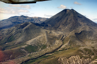
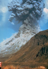
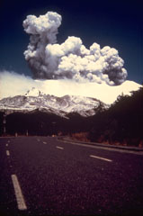
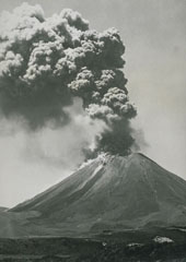 An ash plume rises above Ngāuruhoe volcano on 26 January 1974 in this view from the W. Small pyroclastic flows descend the upper flanks of the cone. Eruptions during 26-28 January and 27-29 March 1974 were the most powerful at Ngāuruhoe in two decades. Explosive activity had been occurring since November 1972 and lasted until August 1974. The dark streaks descending to the base of the cone to the left are lava flows from the 1954 eruption.
Photo by D.L. Homer, 1974 (New Zealand Geological Survey).
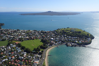
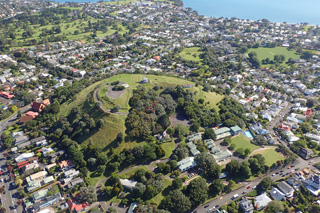 Mount Victoria or Takarunga is a scoria cone with a horseshoe-shaped crater in the Auckland Volcanic Field, seen here in 2018 from the north with the Waitematā Harbour at the top of the photo.
Photo by Bruce Hayward, 2018.
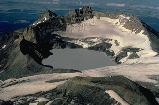 Crater Lake, at the summit of Ruapehu volcano, has produced frequent phreatic explosions during historical time. The depth of the 600-m-wide crater has varied dramatically in recent years, with the maximum depth ranging from 0 to 300 m. Occasionally the lake has been completely drained by explosive eruptions, as occurred most recently in 1996. The 2797-m summit of Ruapehu, Tahurangi Peak, is at the center behind the lake in this view from the north.
 Copyrighted photo by Katia and Maurice Krafft, 1986.
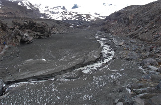
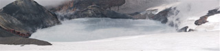 The Ruapehu Crater Lake is seen here on 4 March 2007 from the N, looking towards the tephra dam that failed on the 18th, resulting in 11% of the water draining through lahars down the Whangaehu valley on the E flank and down the N flank. The water temperatures fluctuate through time with geothermal activity below the lake.
Photo by Janine Krippner, 2007.
 Ōhinerau or Mount Hobson is seen here from the west in 2018. The morphology has been extensively modified by pre-European Māori settlement that was later damaged by quarrying and reservoir construction.
Photo by Bruce Hayward, 2018.
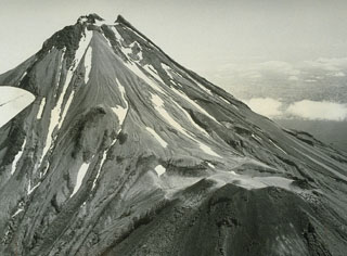 An aerial view from the south shows Taranaki, with its parasitic cone Fanthams Peak at the bottom right. The summit contains a partially destroyed lava dome and four other lava domes are located low on the S and N flanks. Taranaki collapsed and rebuilt itself repetitively during the late Pleistocene and Holocene.
Photo by Jim Cole, 1971 (University of Canterbury).
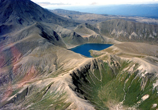
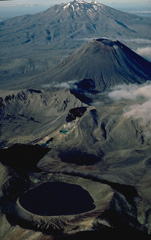 An aerial view from the north shows the Tongariro volcanic centre in the foreground with massive Ruapehu volcano in the background. The Tongariro volcanic centre consists of a dozen or more partially overlapping volcanoes. The 400-m-wide Blue Lake crater, in the foreground, erupted about 9700 years ago. The small Red Crater, at the center, had minor eruptions during the 19th and 20th centuries, and the symmetrical Ngāuruhoe stratovolcano behind it has been one of New Zealand's most frequently active volcanoes during historical time.
Copyrighted photo by Katia and Maurice Krafft, 1986.
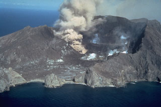
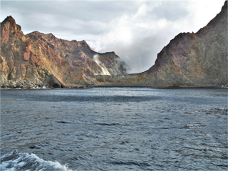 This August 2005 view is looking into the Whakaari/White Island crater through Wilson Bay at the SE of the island. Steam and gases are rising from the crater lake at the far end of the crater, as well as from fumaroles along the crater rim. The units exposed in the inner and outer walls are variably weathered and oxidized lavas, tuffs, and breccias.
Photo by Janine Krippner, 2005.
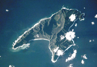 Anvil-shaped Raoul Island is the largest and northernmost of the Kermadec Islands. Two calderas are prominent in this International Space Station view with N to the upper right. The 2.5 x 3.5 km caldera cuts the center of the island, and the E wall of the partially submerged Denham Bay caldera rises above the smooth coastline at the left-center. The 6.5 x 4 km wide Denham Bay caldera formed during a major dacitic explosive eruption about 2,200 years ago, which truncated the W side of the island.
NASA International Space Station image ISS002-E-8883, 2001 (http://eol.jsc.nasa.gov/).
 Ngāuruhoe is at the southern end of the Tongariro volcanic complex, seen here from the SW with the northern Tongariro complex to the left. Lava flows erupted during the 1954-55 eruption are visible down the flank to the left, originating from the summit scoria cone. Pukekaikiore is below the W flank (left) and is the remnant of an older eruption center of Tongariro.
 Photo by John A Krippner, 1995-1996.
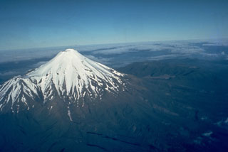
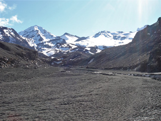
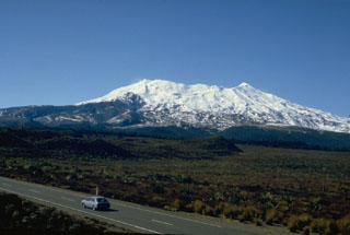 New Zealand's Ruapehu volcano, seen here from the W, has been constructed by incremental growth of partially overlapping volcanic edifices during the past 250,000 years. The compound volcano has a volume of 110 km3, and another 100 km3 of volcaniclastic debris forms a ring plain surrounding Ruapehu. Te Heu Heu and Girdlestone Peaks form the high points at the N and S ends, respectively.
Photo by Jim Cole (University of Canterbury).
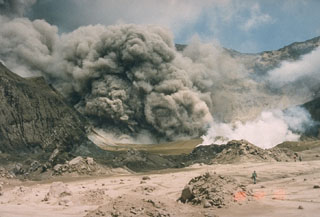
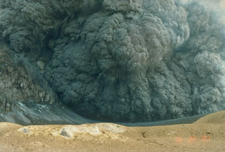 An ash plume erupting from the crater of White Island (also called Whakaari) on 25 March 1988. This was one of many phreatomagmatic and magmatic eruptions that took place from 1986 to 1994 from the small island volcano 50 km NE of New Zealand's North Island. Large eruptions on 14 March and 27 April 1988, produced 3.5-km-high ash plumes.
Photo by Ian Nairn, 1988 (New Zealand Geological Survey).
 This September 1995 photo shows a Surtseyan plume at Ruapehu during the eruption through Te Wai ā-Moe (Crater Lake), forming the dark cock’s-tail plume above the vent and a gas-and-steam plume to the left from the lake water. Two lahar paths descend the Whakapapa ski field on the northern flank in the foreground. A third lahar traveled down the eastern flank Whangaehu Valley.
Photo by John A Krippner, 1995.
 This 22 August 2005 photo shows the E side of the Whakaari/White Island Central Cone showing the exposed stratigraphy of tuff, lava, and breccia units. The gas-and-steam plume rising from the active vent is visible above the flank.
Photo by Janine Krippner, 2005.
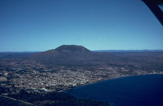 An aerial view shows the E margin of Lake Taupo with Taupo City on its shore. The 35-km-wide caldera is not topographically prominent but has been the source of powerful rhyolitic eruptions from the late Pleistocene throughout the Holocene. The 35,000-year-old Tauhara lava dome forms the peak in the background.
Photo by Jim Healy (New Zealand Geological Survey).
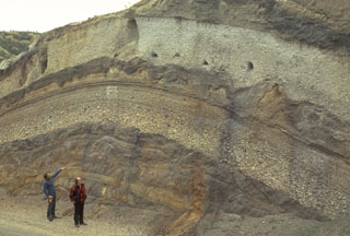 Volcanologists Colin Wilson and Peter Ballance examine a roadcut that dissects deposits of major eruptions from the Taupo volcanic center. The bottom visible unit is an exposure of an unwelded pyroclastic flow deposit from the Oruanui eruption, which formed Taupo's initial caldera about 22,600 years ago. Light-colored pumice fall deposits from other major eruptions are between it and the deposits of the 1,800-year-old Taupo eruption (upper right), which were responsible for Taupo's second caldera.
Photo by Bruce Houghton (Wairakei Research Center).
 Tangaroa submarine volcano in the southern Kermadec Arc is elongated in a NW-SE direction with a summit that rises to within 600 m of the sea surface. It lies between the Clark and Rumble V submarine volcanoes near the southern end of the Kermadec arc. It is one of more than a half dozen volcanoes in this part of the arc showing evidence for active hydrothermal vent fields. Smaller cones lie on the SE flank, and a larger edifice is located further SE.
Courtesy of Ian Wright (National Institute of Water and Atmospheric Research (NIWA), Wellington, New Zealand).
 The flat-topped Tarawera lava dome complex at the top of the photo to the NE is one of two large dome complexes forming the Okataina Volcanic Centre at the N end of the Taupo Volcanic Zone. An eruptive fissure that cuts the dome complex and extends across Lake Rotomahana to the foreground was the source of a major eruption in 1886. The Tarawera complex and the Haroharo complex off the photo to the left were both sources of major explosive eruptions during the Pleistocene and Holocene that produced large ignimbrite sheets.
Photo by Lloyd Homer, courtesy of Bruce Houghton (Wairakei Research Center).
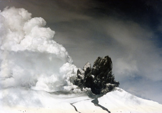
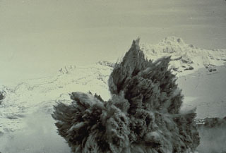
 Pyroclastic flows traveling down the flanks of Ngāuruhoe volcano on 19 February 1975 as an ash plume rises above the summit crater. The eruption column rose 12 km above the vent and ash fell 160 km away in Hamilton City. Explosive activity had begun on the 12th and continued until the 23rd.
Photo by Graham Hancocks, 1975 (New Zealand Geological Survey).
 This view from the Ngāuruhoe summit to below the SW flank shows the lava flows emplaced during the 1954-55 eruption, down the Tongariro flank and around the eroded Pukekaikiore cone. They overlie older lava flows from the same vent.
Photo by Janine Krippner, 2008.
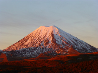
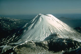 Snow-capped Ngāuruhoe, seen here from the NE, rises 800 m above its surroundings and is the highest peak of the Tongariro massif. This large massif is located immediately NE of Ruapehu volcano, and is comprised of more than a dozen cones and craters. Frequent explosive eruptions have been recorded from Ngāuruhoe since 1839.
Photo by Don Swanson, 1984 (U.S. Geological Survey).
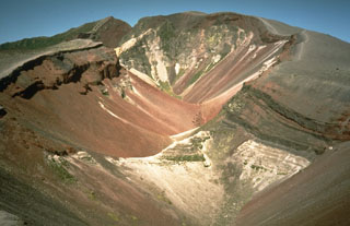
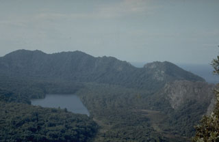 The caldera wall seen here is the N and E portion of the youngest Mayor Island caldera that formed about 6,300 years ago. The 2.2 x 2.5 km caldera floor is covered by young lava flows, the latest of which may have been erupted only about 500-1,000 years ago.
Photo by Jim Cole (University of Canterbury).
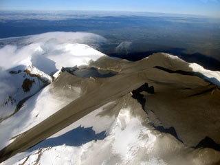
 Te Wai ā-Moe (Crater Lake) is seen here within the Ruapehu southern crater with little water remaining during the 1995-96 eruption. Ash and ballistics were deposited onto the glaciers around the summit and much of the crater is exposed. The crater dimensions have changed throughout eruptions, with a 1993 publication noting a lake depth of 134 m. In recent times it typically has a lake volume of 9 million m3 (as of January 2022).
 Photo by John A Krippner, 1995-1996.
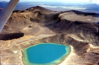 The Blue Lake vent of the Tongariro volcanic complex is in the foreground of this 1995-96 photo, looking SW. The roughly 1-km-wide North Crater is to the right and to the left is a post-1.85 ka lava flow from Red Crater that was emplaced into Central Crater (not of eruption origin).
Photo by John A Krippner, 1995-1996.
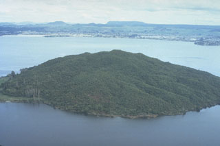
 Motukorea (also known as Brown's Island) in Waitemata Harbour, New Zealand, is composed of a remnant tuff ring (right side), scoria cones (center), and lava flows that form the flat peninsula in the foreground. It is one of more than 50 Pleistocene-to-Holocene centers in the Auckland Volcanic Field. The low-angle slopes of lava flows from Rangitoto are visible to the north in the background.
Photo by B. Thompson (published in Green and Short, 1971).
 This snow-slurry lahar formed through brief explosions through the acidic Ruapehu Crater Lake, ejecting around 5,700 m3 of acidic water then entraining 60 times this volume in snow. This view looks up the Whangaehu valley towards the Crater Lake area two days after it was emplaced across the valley floor.
Photo by Janine Krippner, 2007.
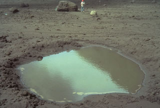 This 4-m-wide, water-filled impact crater was formed when the block in background, with volcanologist Ian Nairn providing scale, was ejected during an eruption from White Island in New Zealand in late March 1977. The block, composed of pre-existing crater wall rock, bounced to form the impact crater, and then slid to its present location, 250 m from the source vent.
Photo by Bruce Houghton, 1977 (Wairakei Research Center).
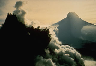
 An eruption from White Island (also called Whakaari) on 12 February 1977 is viewed from off the NE coast. The ash plume originates from the Christmas Crater vent, formed the previous year, shortly after the start of the eruption on 18 December. The first 20th century eruption to produce new magmatic material took place a month after the date of this photo. Intermittent phreatomagmatic eruptions continued until late 1981.
Photo by Simon Nathan, 1977 (New Zealand Geological Survey).
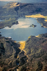
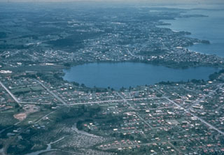
 The 17-km-wide Rotorua caldera, largely filled by the waters of Lake Rotorua, was formed during the eruption of the 340 km3 Mamaku Ignimbrite about 220,000 years ago. Eruptive activity ceased during the Pleistocene, but the Mokoia lava dome, forming the island in the foreground, is less than 20,000 years old. Geothermal areas are found around the lake and the city of Rotorua lies across the lake along its southern shore.
Photo by Bruce Houghton (Wairakei Research Center).
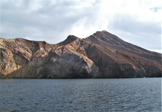
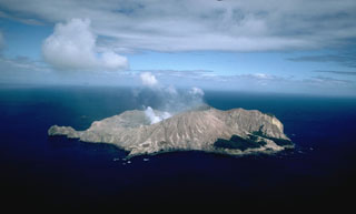 White Island (also called Whakaari), seen here from the NE, is a low (~300-m-high), 2 x 2.4 km wide, uninhabited island off the coast of New Zealand's North Island. This is one of New Zealand's most active volcanoes, with frequent explosive eruptions recorded since 1826 that have deposited tephra over the island, preventing the growth of vegetation in all but a few small areas along the coast.
Copyrighted photo by Stephen O'Meara.
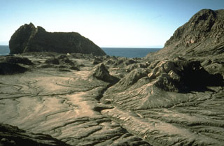
 This large fissure produced during a major explosive eruption at Tarawera in 1886 is one of the youngest eruption features of the Okataina Volcanic Centre. Okataina is surrounded by extensive ignimbrite and pyroclastic deposits produced during caldera-forming eruptions. The subparallel NE-SW-trending Haroharo and Tarawera complexes consist of rhyolitic lava domes and associated lava flows that formed between about 15,000 and 800 years ago and impounded lakes against the margins of the Okataina ring structure.
Photo by Richard Waitt, 1986 (U.S. Geological Survey).
 Pigeon Mountain or Ōhuiarangi is a scoria cone that has been modified by quarrying, seen in the triangular grassy area near the center of the photo. Rangitoto volcano is in the background of this 2018 photo showing part of the Auckland Volcanic Field.
Photo by Bruce Hayward, 2018.
 The Ngāuruhoe cone reaches around 900 m above the Tongariro volcanic complex. Seen here from the W in 2012, the summit scoria cone mostly formed in 1954-55 within the larger summit crater area. The older crater rim is on the right side of the summit in this view.
Photo by Janine Krippner, 2012.
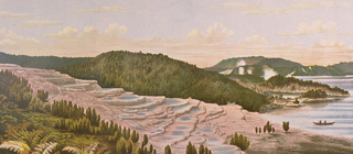 The renowned hot spring terraces at Rotomahana, one of the scenic wonders of New Zealand until the 19th century, were destroyed and buried by the 1886 eruption of Tarawera. Otukapuarangi (the Pink Terrace), shown here, and the nearby Te Tarata (the White Terrace), had been among the world's most spectacular hot spring terraces, attracting visitors from around the world.
From the collection of Maurice and Katia Krafft.
 A series of minor phreatic eruptions, such as this one on 21 February 1982, took place from Crater Lake at the summit of Ruapehu volcano from October 1981 until April 1982. This eruption, seen here from the crater rim, is small compared to others that have taken place at Crater Lake.
Photo by Brad Scott, 1982 (New Zealand Geological Survey).
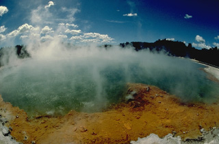 Steaming Champagne Pool is one of many thermal features of the 10-km-wide Reporoa caldera. The caldera was formed about 230,000 years ago during the eruption of the Kaingaroa ignimbrite. No eruptions have occurred since the Pleistocene in the caldera, but hydrothermal explosions took place in the Waiotapu thermal field north of the caldera at the time of the Kaharoa eruption of the Okataina volcanic centre about 800 years ago. The Broadlands (Ohaki) hydrothermal field is located south of the poorly defined caldera margin.
Copyrighted photo by Katia and Maurice Krafft, 1986.
 A Surtseyan eruption on 8 May 1971 at Crater Lake at the summit of Ruapehu volcano in New Zealand ejects a dark cock’s tail jet of volcanic ash, mud, and steam. Individual ejected blocks can be seen at the margins of the plume. This type of eruption column is typical of explosions that involve water-magma interactions.
Photo by Peter Otway, 1971 (New Zealand Geological Survey).
 A New Zealand Geological Survey volcanologist on the crater floor of White Island (also called Whakaari) volcano observes an ash plume on 9 February 1989. This was one of many small-to-moderate explosive eruptions that took place between 1986 and 1994.
Photo by Ian Nairn, 1989 (Geological Survey of New Zealand).
 A dark cock's-tail plume is ejected from Crater Lake during the 8 May 1971 eruption of Ruapehu. This view from the NW shows Mitre Peak in the background at the onset of the eruption, which ejected material to 1.5 km above the crater. It was the largest of a series of phreatic and phreatomagmatic eruptions from 3 April to November.
Photo by Peter Otway, 1971 (New Zealand Geological Survey).
 This basaltic scoria cone is one of 30 Pleistocene to early-Holocene eruptive centers in the Kaikohe-Bay of Islands volcanic field in NW-most North Island, New Zealand. The most recent eruptions produced scoria cones and lava flows near Te Puke about 1,300-1,800 years ago. The volcanic field also contains small shield volcanoes, along with small rhyolitic lava flows and domes.
Photo by Jim Cole (University of Canterbury).
 Ruapehu volcano, seen here from the south, forms a massif composed of at least four overlapping volcanic edifices. Located at the southern end of the Taupo volcanic zone, it contains an active crater lake near the summit. Phreatic explosions have produced mudflows that have affected ski areas on the upper flanks and river valleys below the volcano.
Photo by Bruce Houghton, 1980 (Wairakei Research Center).
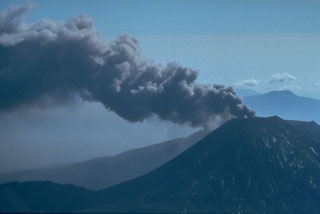
 An eruption plume rises above the summit of Ruapehu on 11 November 1977, as seen from 5 km N of the summit on the ski area access road near Whakapapa village. Minor phreatic eruptions began in July and lasted until January 1979. The larger explosions in November produced pyroclastic surges in the summit crater area and a lahar down the Whangaehu River on the E flank.
Photo courtesy Bruce Houghton, 1977 (Wairakei Research Center).
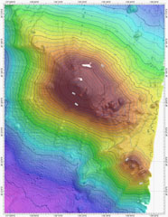
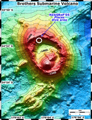 A bathymetric map of Brothers submarine volcano. The NZASRoF 2005 Pisces V dives are indicated in the NW caldera area. The contour interval is 100 m and the resolution of the bathymetry data is 25 m. The bathymetry data are provided courtesy of the New Zealand National Institute of Water and Atmospheric Research (NIWA).
Image courtesy of New Zealand-American Submarine Ring of Fire 2005 Exploration, NOAA Vents Program.
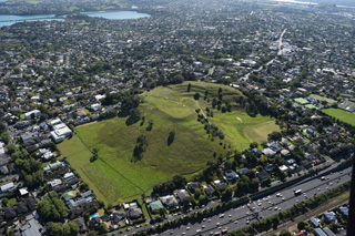
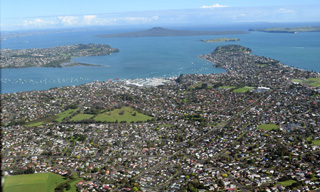
 Auckland, New Zealand's largest city, is constructed over the 600 km2 Auckland Volcanic Field. The field contains more than 50 maars, tuff rings, and scoria cones that were formed during eruptions over the past 193,000 years. Only one volcano was formed during the Holocene. About 620-570 years ago, two phases of eruptive activity formed a low shield volcano capped by a scoria cone at Rangitoto.
Photo by Jim Cole (University of Canterbury).
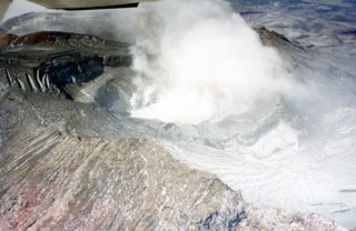
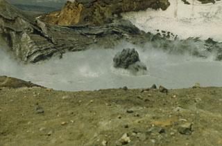
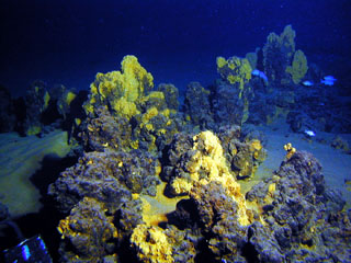 Iron and silica-rich chimneys on the summit of Giggenbach volcano are evidence of warm springs that were active at this site in the past.
Image courtesy of New Zealand-American Submarine Ring of Fire 2005 Exploration, NOAA Vents Program.
 This 2018 photo from the SW shows the North Head or Maungauika scoria cone and Rangitoto in the background. Rangitoto is the largest volcanic feature in the Auckland Volcanic Field and unlike the other monogenetic centers, it formed over at least two eruptive episodes.
Photo by Bruce Hayward, 2018.
 An aerial view of the summit of Ruapehu from the NE on 26 September 2007 show the effect of a brief eruption the previous day. The eruption originated from Crater Lake (left-center), and ejected ash and mud that covered much of the summit area. A large lahar swept down the Whangaehu glacier to the left and a smaller lahar exited the low point on the rim of Crater Lake and descended the narrow gully above the larger lahar.
Photo courtesy of GeoNet, 2007 (Global Volcanism Network Bulletin).
 Taranaki volcano dominates the W coast of New Zealand's North Island. The stratovolcano, seen here from the S, is surrounded by a ring plain of debris avalanche and lahar deposits produced by repetitive collapse of the volcanic edifice. It has been active throughout the Holocene. The latest eruption of Taranaki took place in 1854 CE.
Photo by Jim Cole (University of Canterbury).
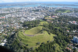 Maungawhau or Mount Eden is seen here in 2018 with the Auckland city center in the background. It is a scoria cone with a 50-m-deep crater and surrounding lava flows, and is one of around 50 vents within the Auckland Volcanic Field.
Photo by Bruce Hayward, 2018.
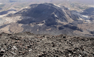
 The small hills in the foreground are debris avalanche hummocks from a landslide on White Island in September 1914. The landslide occurred when part of the crater rim collapsed in the absence of any eruptive activity. The high-velocity avalanche swept across the crater floor, destroying the buildings of a sulfur-mining plant and burying 11 workers. The large hill in the background to the SE is not an avalanche hummock but a remnant of the outer crater wall.
Photo by Richard Waitt, 1986 (U.S. Geological Survey).
 The Upper Tama Lake is in the center of this photo with the southern flank of Ngāuruhoe to the right, both of which are eruption centers of the Tongariro volcanic complex. The lake fills several craters that were active around 10,000 years ago, with lava flows s180,000-200,000 years old forming the cliffs surrounding it.
Photo by John A Krippner, 1995-1996.
 An ash plume on 29 March 1974, is directed by the wind from the summit of Ngāuruhoe volcano one day after powerful explosions that were accompanied by pyroclastic flows. Intermittent explosive eruptions had been occurring since 22 November 1972 and continued until 19 August 1974. Eruptions in January and March 1974 were the largest in two decades from Ngāuruhoe.
Photo by Jim Cole, 1974 (University of Canterbury).
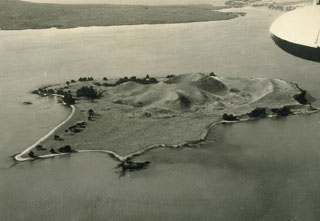
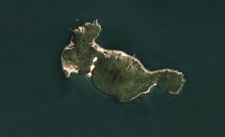 Moutohorā Island (Whale Island) is 11 km offshore from Whakatane in New Zealand, seen in this 21 November 2019 Sentinel-2 satellite image (N is at the top). The 2.5-km-long (E-W direction) island has three main features: East Dome, the Central Dome complex, and the northwestern Pa Hill.
Satellite image courtesy of Planet Labs Inc., 2019 (https://www.planet.com/).
 The 25 September 2007 Ruapehu ice-slurry lahar emplaced the deposit across this photo, seen here two days later in the Whangaehu valley on the E flank. The path of the lahar from Crater Lake down the Whangaehu glacier is above it.
Photo by Janine Krippner, 2007.
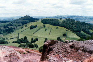 A group of scoria cones, one partially quarried in the foreground, lies at the NW side of the harbor city of Whangarei. The Whangarei volcanic field consists of Quaternary basaltic scoria cones and lava flows. The youngest basalts were initially mapped as Holocene, although the age of the field is not well known and could be late Pleistocene.
Photo by Ichio Moriya (Kanazawa University).
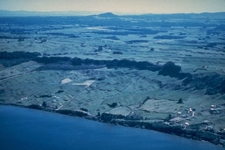 The northern margin of the 17-km-wide Rotorua caldera is defined by the dark line of trees along the cliff at the center of the photo. A succession of terraces marking former lake levels can be seen on the shore of Rotorua Lake. Rotorua is the NW-most of a cluster of calderas forming the Taupo Volcanic Zone in the central North Island.
Photo by Lloyd Homer (courtesy of Bruce Houghton, Wairakei Research Center).
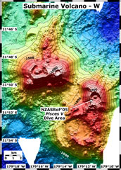 This map view shows two submarine volcanoes known informally as Volcano W. The Pisces V dive area during a 2005 New Zealand-American expedition is indicated on the SE caldera. The contour interval is 100 m and the resolution of the bathymetry data is 25 m. The bathymetry data are proprietary and provided courtesy of Ian Wright, New Zealand National Institute of Water and Atmospheric Research (NIWA).
Image courtesy of New Zealand-American Submarine Ring of Fire 2005 Exploration, NOAA Vents Program.
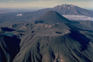 The Tongariro volcanic massif is a complex of more than a dozen composite volcanic cones erupted along a NE-SW line. Flat-topped North Crater in the foreground and conical Ngāuruhoe behind it are the two most prominent Tongariro volcanoes. North Crater's broad, flat top is the surface of a former lava lake; a small explosion crater later punctured its right side. Most historical eruptions of Tongariro have originated from the symmetrical Ngaurohoe stratovolcano. Ruapehu volcano forms the broad massif in the distance to the south.
Copyrighted photo by Katia and Maurice Krafft, 1986.
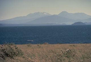 This view looking SW across Lake Taupo, the southernmost major caldera of the Taupo Volcanic Zone, shows several major peaks of Tongariro and Ruapehu. The broad forested peak below the center horizon is the Pleistocene Pihanga volcano. The steep-sided cone on the horizon to its right is Ngāuruhoe, the youngest cone of the Tongariro complex. The broad massif to its right is Tongariro. The snow-capped massif on the left-center horizon is Ruapehu.
Photo by Tom Simkin, 1986 (Smithsonian Institution).
 Mangere Lagoon is a tuff ring within the Auckland Volcanic Field, seen here from the south in 2018, with the Mangere Mountain scoria cone to the upper right. Rangitoto is in the distance.
Photo by Bruce Hayward, 2018.
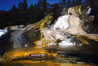 Algae colors the surface of siliceous sinter terraces at the Orakei Korako thermal area. This geothermal area is one of the principal hydrothermal fields of the Taupo Volcanic Zone. It lies on the banks of the Waikato River where the Paeroa Fault divides into smaller branches that intersect the E margin of the Maroa Volcanic Center. Orakei Korako contains sinter sheets covering an area of about 1 km2. Flooding of the river hydroelectric power generation has drowned about 70% of the hot springs.
Photo by Richard Wysoczanski, 1994 (Smithsonian Institution).
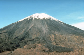 Snow-capped Ngāuruhoe volcano rises above the Mangatepopo track on the NW side of the volcano. The dark lobe in the right foreground is a deposit produced by lithic-rich pyroclastic flows during the 1975 eruption. Meter-scale ballistic blocks from powerful Vulcanian explosions during the 1975 eruption were ejected out to distances of 2.8 km, beyond the location of this photo.
Photo by Don Swanson, 1984 (U.S. Geological Survey).
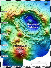 Map view shows Monowai submarine volcano at the lower left, with subsidiary cones on its N flank. A large submarine caldera lies to the NE at the top-right. The contour interval is 100 m and the resolution of the bathymetry data is 25 m. The proprietary bathymetry data were obtained by scientists of the New Zealand National Institute of Water and Atmospheric Research (NIWA) during a 2005 New Zealand-American NOAA Ocean Explorer research expedition to the Kermadec-Tonga Arc.
Image courtesy of Ian Wright, 2005 (NIWA; http://oceanexplorer.noaa.gov/explorations/05fire).
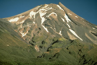 Taranaki volcano (previously called Egmont) has a breached summit crater that is occupied by a partially-destroyed lava plug. This view from the SE shows the stacked lava flows that form much of the cone, with the vegetated slopes of the parasitic cone, Fanthams Peak, at the left.
 Photo by Chris Newhall, 1986(U.S. Geological Survey).
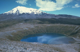 Lower Tama Lake on Tongariro was formed late in a series of eruptions that began about 10,000 years ago. The eruptions included the emplacement of two lava flows from Upper Tama Lake with a combined volume of 0.2 km3 and a smaller lava flow from Lower Tama Lake.
Photo by Jim Cole (University of Canterbury).
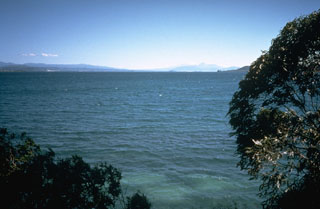 Lake Taupo fills a roughly 35-km-wide caldera that is the site of the most prolific rhyolitic volcano of the Taupo volcanic zone. The caldera was formed during two major explosive eruptions, the Oruanui eruption, roughly 22,600 years ago, and the Taupo eruption, about 1,800 years ago. The latter was one of the world's largest Holocene eruptions. Additional Plinian eruptions during the Holocene have produced widespread airfall pumice deposits.
Photo by Richard Waitt, 1986 (U.S. Geological Survey).
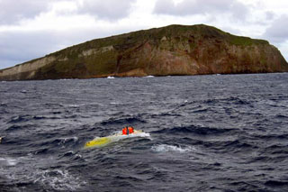 The submersible vessel Pisces V surfaces in the foreground after a dive in front of Macauley Island during a 2005 New Zealand-American NOAA Ocean Explorer research expedition to the Kermadec Arc. This view from the NW shows a prominent white band in the cliff face that is made of dacite pyroclastic flow deposits. The 3-km-wide Macauley Island is a remnant of the rim of a large submarine caldera centered 8 km to the NW and has a low, gently sloping surface truncated by steep cliffs.
Image courtesy of NOAA, 2005 (http://oceanexplorer.noaa.gov/explorations/05fire).
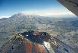 The Ngāuruhoe summit of the Tongariro volcanic complex is in the foreground, while in the background is a weak plume produced during the 1995-96 Ruapehu eruption, dispersing to the SW. The scoria cone within the Ngāuruhoe crater largely formed during the 1954-55 eruption and produced lava flows down the NW to W flanks.
Photo by John A Krippner, 1995-1996.
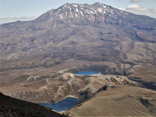 This 2008 view is from the Ngāuruhoe summit at Tongariro, to the south towards Ruapehu. In the foreground are the Upper Tama (foreground) and Lower Tama lakes, vents that predate formation of the Ngāuruhoe cone.
Photo by Janine Krippner, 2008.
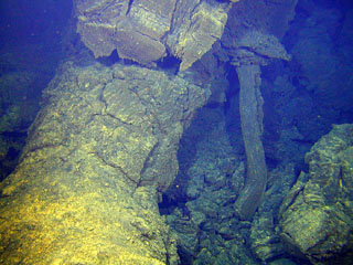 Two submarine volcanoes, known informally as Volcano W, were discovered during a New Zealand-American mapping expedition in 2004. This view taken at the SE volcano from a submersible vehicle during a 2005 expedition shows lava extruding from a tube before it solidified in place. The SE volcano rises to within about 900 m of the sea surface and contains a cone in its summit caldera.
Image courtesy of New Zealand-American Submarine Ring of Fire 2005 Exploration, NOAA Vents Program.
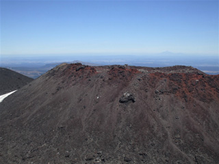 The scoria cone within the Ngāuruhoe summit crater largely formed during the 1954-55 eruption and was the location of the 1974-75 eruption, seen here from the larger crater rim to the E. The Ngāuruhoe cone is at the southern end of the Tongariro volcanic complex and is one of the youngest features. Taranaki is to the W, visible in the distance.
Photo by Janine Krippner, 2008.
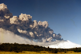 Ruapehu is seen here erupting on 17 June 1996 with a narrow ash plume that rose 8.5 km and extended 200 km NE from the vent. Ash is falling from the plume and is being carried by the wind below it. As well as impacting water, and power supplies, ash from this eruption effected agriculture and caused livestock fatalities.
Photo by John A Krippner, 1996.
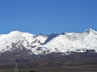 The 25 September 2007 Ruapehu lahar that travelled down the Whangaehu Valley is seen here from the E two days later. The black deposit in the center includes two lahar descent paths that merged, and ash and mud deposits from the explosion that occurred within Crater Lake.
Photo by Janine Krippner, 2007.
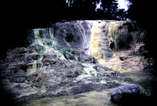 Multi-colored Bridal Veil Falls were formed from silica terraces created when mineralized water poured over from the Primrose Pool of the Wai-O-Tapu thermal area. The noted hydrothermal area lies within the 10-km-wide Reporoa caldera, which was formed during the Pleistocene in the Reporoa-Broadlands basin near the western margin of the Taupo volcanic zone. Large hydrothermal explosions took place from the Wai-O-Tapu thermal area at the time of the Kaharoa eruption of neighboring Tarawera volcano (Okataina Volcanic Centre) about 700 years ago.
Photo by Richard Wysoczanski, 1994 (Smithsonian Institution).
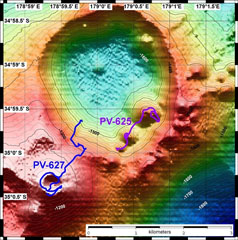 A bathymetric map of Healy submarine volcano is overlain by dive tracks of the submersible vehicle Pisces V. Dive depths range from 1,120 to 1,490 m. The resolution of the bathymetry data is 25 m, and the contour interval is 20 m. Roughly 600-year-old pumice deposits found on the shores of North Island, New Zealand, originated from Healy. The bathymetry data were obtained during a 2005 New Zealand-American NOAA Ocean Explorer research expedition to the Kermadec Arc.
Image courtesy of New Zealand-American Submarine Ring of Fire 2005 Exploration, NOAA Vents Program.
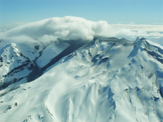 The 25 September 2007 eruption of Ruapehu produced lahars on the N and E flanks from Crater Lake, with the E flank lahar seen here. Two lahar descent paths are visible, the wider one closer to the center down the Whangaehu Glacier, and the narrower path further to the left down the Whangaehu valley. The lahar merged and continued for 200 km along the Whangaehu River.
Photo by Janine Krippner, 2007.
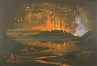 This painting shows the 10 June 1886, eruption of Tarawera, as seen across Lake Tarawera from the NW. A brief, but powerful explosive eruption lasting 5 hours originated from a NE-trending fissure that cut across the Tarawera lava dome complex. The eruption ejected 2 cu km of basaltic tephra and produced pyroclastic surges that traveled at least 6 km from the vent. Several villages were buried, and 153 people were killed.
 Chromolithograph of oil painting by Charles Blomfield (from the collection of Maurice and Katia Krafft).
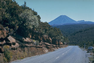 A roadcut along the desert road between Waiouru and Turangi exposes some of the tephra layers erupted from the Tongariro volcanic complex during its early stage of development. Ngāuruhoe is the visible cone in the background.
Photo by Jim Cole (University of Canterbury).
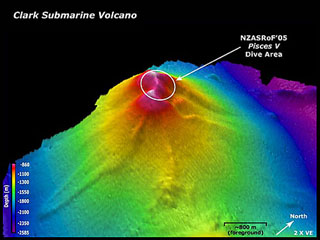 Clark submarine volcano is viewed here from the SE. The location of a submersible dive took place a New Zealand-American NOAA Vents Program expedition is indicated. Depths range from 860 to 2,585 m. The resolution of the bathymetry data is 25 m. The image is two times vertically exaggerated. The bathymetry data are courtesy of New Zealand National Institute of Water and Atmospheric Research (NIWA).
Image courtesy of New Zealand-American Submarine Ring of Fire 2005 Exploration, NOAA Vents Program.
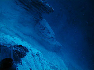 Many of the pits on the summit of Giggenbach volcano show layered ash deposits that are evidence for violent eruptions in the past. It lies NW of Macauley volcano and is named after volcano gas geochemist Werner Giggenbach. The flat summit is cut by a 700-m-wide crater containing a central cone and a large hydrothermal vent field was found within the summit crater.
Image courtesy of New Zealand-American Submarine Ring of Fire 2005 Exploration, NOAA Vents Program.
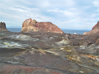 This August 2005 looks across the Whakaari/White Island Eastern Crater towards Troup Head. Across the crater floor are hummocks, 1-3 m high, from the 1914 debris avalanche and hydrothermal alteration products.
 Photo by Janine Krippner, 2005.
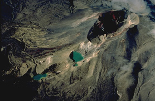 Red Crater (upper right) is one of a dozen or more volcanic centers of the Tongariro volcano group. The Emerald Lakes, NE of Red Crater, mark a chain of explosion vents associated with eruptions of Red Crater. Activity at Red Crater continued into historical time. Minor phreatic explosive eruptions took place during the late 19th century and most recently in 1926.
Copyrighted photo by Katia and Maurice Krafft, 1986.
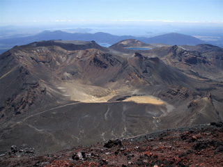 This 2008 view from the Ngāuruhoe summit (red scoria at the bottom) looks across Tongariro and to Lake Taupō in the distance. Within Tongariro going in a clockwise direction, South Crater is in the foreground, North Crater is to the upper left, Blue Lake is to its right, and Red Crater is below it.
Photo by Janine Krippner, 2008.
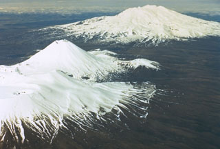 Tongariro, in the foreground, is a cluster of about a dozen cones and craters dominated by the symmetrical Ngāuruhoe cone. Ruapehu, in the background to the south, contains a frequently active crater lake. The two volcanoes have been two of the most frequently active in New Zealand.
Photo by New Zealand Geological Survey, 1981.
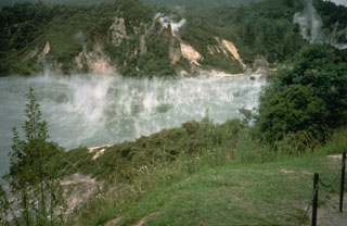 The steaming Waimangu hot pool is located near the southern end of the 1886 Tarawera eruptive fissure. Intermittent phreatic eruptions took place from this and other craters south of Lake Rotomahana from 1886 until as recently as 1973. Waimangu (black water) geyser was active from 1900 until activity ceased on 1 November 1904.
Photo by Richard Waitt, 1986 (U.S. Geological Survey).
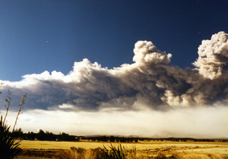 This 17 June 1996 photo shows the ash plume produced during the Ruapehu eruption that extended out to around 200 km, drifting over the Pacific Ocean. Below the main plume is the ash redispersing from the deposit emplaced across a narrow swath NE of the volcano.
Photo by John A Krippner, 1996.
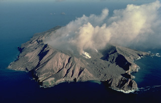 Steam and ash clouds rise from the crater of White Island, one of New Zealand's most active volcanoes, in this 1986 view from the SW. The small, uninhabited 2 x 2.4 km wide island is the summit of a largely submerged volcano 50 km offshore from the coast of North Island. The volcano contains two overlapping craters 0.4 x 1.2 km wide that have been the source of frequent intermittent moderate steam-and-ash eruptions since the beginning of historical observations in 1826.
 Copyrighted photo by Katia and Maurice Krafft, 1986.
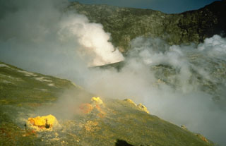 Sulfur deposits on the margins of fumarole vents on White Island volcano (also called Whakaari), with steam rising above a larger vent in the background. This photo was taken shortly after the beginning of an explosive eruption in February 1986 that lasted until July 1994.
Photo by Richard Waitt, 1986 (U.S. Geological Survey).
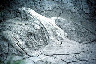 Mud extruding from a small vent in a geothermal area of the Rotorua caldera resembles a lava flow with the flow ridges perpendicular to the direction of movement. Desiccation cracks cut the surface of the older surrounding mud.
Photo by Tom Simkin, 1986 (Smithsonian Institution).
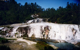 Siliceous sinter terraces located within the at Orakei Korako thermal areas in New Zealand. The thermal area lies along the Waikato River at an elevation of 260-360 m on the E side of the Maroa volcanic center. Hydrothermal explosions took place at five centers at Orakei Korako prior to the Taupo pumice eruption about 1,800 years ago, depositing explosion breccias that immediately underlie the Taupo Pumice.
Photo by Richard Wysoczanski, 1994 (Smithsonian Institution).
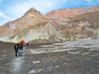 Tourists walk across the Whakaari/White Island crater floor in August 2005. The crater wall behind them is composed of lavas, breccias, and tuff deposits.
Photo by Janine Krippner, 2005.
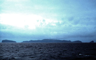 The isolated, uninhabited Antipodes Islands, seen here from the north, are located in the south Pacific, 770 km SE of New Zealand. Volcanism has been dominantly pyroclastic, and the presence of well-preserved scoria cones suggests a Holocene age. The most recent eruptions occurred on the cone forming Mount Galloway and Mount Waterhouse at the center of Antipodes Island. Bollons Island, at the left, lies off the NE coast of the 4-km-wide main island.
 Photo by Benjamin Hell, 2003 (wikimedia commons, http://creativecommons.org/licenses/by-sa/2.5/).
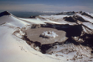 A small phreatic eruption on 29 February 1980, produces a column of ash and steam above Ruapehu's Crater Lake. A darker center plume is surrounded by a white ring produced by pyroclastic surges traveling across the lake surface. This view is from the NW, with Mitre Peak at the upper left. A series of small phreatic explosions had begun on 5 December 1979 and lasted until 15 April the following year.
Photo by Peter Otway, 1980 (New Zealand Geological Survey).
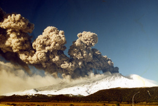 This 17 June 1996 photo shows the eruption of Ruapehu with an ash plume dispersing to the NE. The eruption varied in intensity, causing the differences in plume height with distance from the vent. Ashfall is visible across the flank and a lower plume is from the redispersal of the ash deposit.
Photo by John A Krippner, 1996.
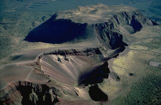 The 1886 eruptive fissure that cuts across the Tarawera lava dome complex was the source of a major explosive eruption that produced 2 cu km of basaltic tephra. The 1886 fissure cuts a group of lava domes, including the Wahanga dome at the top of the photo, which was emplaced at the end of the Kaharoa eruption about 800 years ago. That eruption produced 5 cu km of rhyolitic tephra and and another 2.5 cu km of rhyolitoc lava that formed the Wahanga, Tarawera, Crater Dome, and Ruawahia domes.
Copyrighted photo by Katia and Maurice Krafft, 1986.
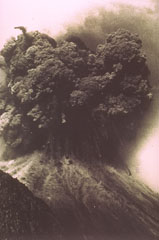 A Vulcanian explosion from the Ngāuruhoe cone of Tongariro volcano in New Zealand on 19 February ejects an ash plume and ballistic ejecta. Blocks up to 20 m across reached hundreds of meters above the vent before impacting the flanks.
Photo by Ian Nairn, 1975 (New Zealand Geological Survey).
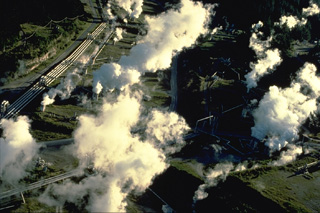 Steam rises from a geothermal plant in the Maroa caldera. The 16 x 25 km caldera formed sometime after 230,000 years ago in the NE corner of the larger Whakamaru caldera. The Maroa caldera was filled by at least 70 rhyolitic lava domes and flows. The latest dated eruption took place about 14,000 years ago at Puketarata. Large hydrothermal explosions have occurred during the Holocene, most recently about 1800 years ago at the time of a major eruption at the neighboring Taupo volcanic centre.
Copyrighted photo by Katia and Maurice Krafft, 1986.
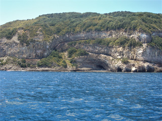 The eroded flank of Mayor Island (Tuhua) shows a sequence of overlapping columnar-jointed lava flows with black obsidian lavas between them.
Photo by Janine Krippner, 2007.
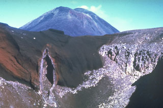 The SE wall of Red Crater is cut by a vertical volcanic dike that fed eruptions along a NE-SW-trending fissure. Magma along the outer part of the dike cooled against the red scoria walls, while magma at the center of the dike partially drained away, leaving this cavity. Ngāuruhoe is visible in the background. These are two of more than a dozen cones and craters forming the Tongariro volcanic complex.
Photo by Jim Cole (University of Canterbury).
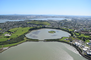 Mangere Lagoon is a tuff ring that formed during a phreatomagmatic eruption in the Auckland Volcanic field. The activity has been linked to the Mangere scoria cone behind it (immediately to the upper left). Rangitoto is to the upper left of this 2018 view from the SW.
Photo by Bruce Hayward, 2018.
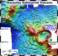 A bathymetric map view shows Macauley and Giggenbach submarine volcanoes in the Kermadec arc with a submersible dive site and Macauley Island labeled. Giggenbach is in the NW corner of the map, and the Pisces submersible dive area is on the eastern rim of Macauley caldera. The map contour interval is 100 m and the resolution of the bathymetry data is 25 m. The proprietary bathymetry data were obtained during a 2005 New Zealand-American NOAA Ocean Explorer research expedition to the Kermadec arc.
Image courtesy of New Zealand Nat. Inst. of Water & Atmospheric Research, 2005 (http://oceanexplorer.noaa.gov/explorations/05fire).
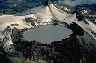 Appropriately named Crater Lake, the historically active summit vent of New Zealand's Ruapehu volcano, is one of the world's most frequently active crater lakes. Nearly 50 explosive eruptions originating from a vent beneath the lake have been recorded during the 20th century. This view from the NW shows the 600-m-wide lake with glacier-clad Mitre Peak in the background.
Copyrighted photo by Katia and Maurice Krafft, 1986.
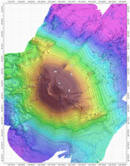 A bathymetric map view shows Rumble V submarine volcano at the southern end of the South Kermadec volcano group. A large plume of gas bubbles was acoustically detected rising from the summit in 1992. Rumble V, the southernmost of a group of seamounts on the southern Kermadec Ridge known as the Rumbles, rises more than 2,000 m to about 400 m below the sea surface.
Courtesy of Ian Wright (National Institute of Water and Atmospheric Research (NIWA), Wellington, New Zealand).
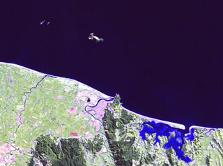 Moutohora (Whale) Island is the elongated island 11 km offshore from the city of Whakatane in the center of this Landsat image. The central dome complex on the 15 x 5 km wide island is about 350 m high and flanked by two lava domes, Pa Hill Dome (also known as West Dome) at the NW tip of the island and East Dome at the opposite end. Eruptive activity ceased during the Pleistocene but thermal activity continues. Rurima Rocks and Moutoko Island lie WNW, and the large bay at the lower right is Ohiwa Harbour.
NASA Landsat image, 2000 (courtesy of Hawaii Synergy Project, Univ. of Hawaii Institute of Geophysics & Planetology).
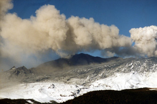 Ash was deposited across several flanks during the 1995-96 Ruapehu eruption. This weak ash plume was dispersed by the wind before it reached a significant height above the crater, with ash falling out of the plume across the dark deposit already covering the snow.
Photo by John A Krippner, 1995-1996.
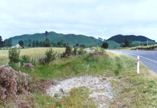 Ngangiho lava dome is one of at least 70 post-caldera lava domes erupted within the Maroa caldera, which formed sometime after about 230,000 years ago N of the Taupo caldera. The youngest of the post-caldera lava domes is Puketarata, which grew within a rhyolitic tuff ring about 14,000 years ago. The domes were erupted along a general SW-NE trend, parallel to the structural trend of the Taupo Volcanic Zone. No Holocene eruptions have occurred, but vigorous thermal activity continues.
Photo by Ichio Moriya (Kanazawa University).
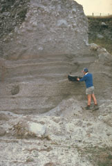 The Kaharoa eruption about 700 years ago was the first Holocene eruption of the Tarawera lava dome complex in the Okataina Volcanic Centre. It produced an extensive rhyolitic tephra deposit that extended to the E coast of North Island. Geologist Pat Brown examines a charcoalized log within a pyroclastic flow deposit from this eruption. The upper part of the section consists of blocky debris from collapse of a rhyolitic lava dome at the end of the eruption.
Photo by Jim Cole (University of Canterbury).
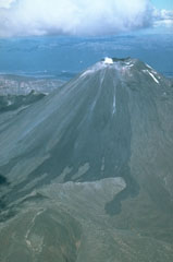 The black lava flows extending from the summit of Ngāuruhoe volcano to its flanks erupted in 1954. An eruption that began with explosive activity on 13 May 1954, was followed on 4 June by the emission of lava flows that traveled down the NW flank until 26 September. Explosive activity, which constructed a scoria cone in the summit crater, continued until March 1955; incandescent lava was present in the crater until June.
Photo by Jim Cole (University of Canterbury).
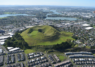 Mount Wellington or Maungarei is a scoria cone in the Auckland Volcanic Field with several summit craters that erupted around 10,000 years ago. This 2018 view from the NNW also shows the Panmure Basin or Te Kopua Kai-a-Hiku maar in the background.
Photo by Bruce Hayward, 2018.
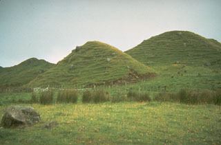 Grass-covered conical hills dot the plains around Mount Taranaki on New Zealand's North Island. Small hills such as these, often located in lowland areas well beyond the flanks of a volcano, were once thought to be scoria cones or small secondary vents produced by explosions when a lava flow passed over a body of water. They are now recognized to be hummocks of massive debris avalanches produced by volcanic landslides or flank collapse. Debris avalanche deposits originating from repetitive collapse surround the volcano to distances of about 40 km.
Photo by Don Swanson, 1984 (U.S. Geological Survey).
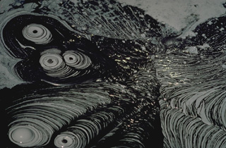 Bubbling mud pots at a thermal area of New Zealand's Reporoa caldera form geometric patterns. Mud pots form in thermal areas where the gas phase is dominant over the liquid phase and extensive hydrothermal alteration of rocks has occurred, producing fine-grained, clay-rich material.
Copyrighted photo by Katia and Maurice Krafft, 1986.
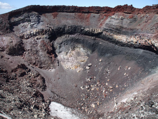 The crater of the Ngāuruhoe scoria cone is seen here from the NW rim on 8 February 2008. The cone formed mainly through a series of Strombolian and Vulcanian eruptions in 1954-55, with the red uppermost scoria unit emplaced in 1974-75.
Photo by Janine Krippner, 2008.
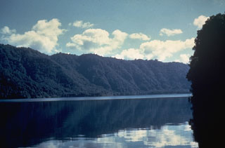 The Haroharo volcanic complex is the NW-most of two lava dome complexes forming the Okataina Volcanic Centre. A 16 x 28 km wide caldera was formed incrementally during eruptions between 300,000 and 50,000 years ago. Its rim, seen in this photo across the caldera lake, is generally obscured by a group of overlying lava domes. All post-caldera domes are less than 20,000 years old, and the most recent Haroharo eruption took place about 3,500 years ago.
Photo by Ian Nairn (Geological Survey of New Zealand).
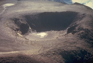 An aerial view from the south in the late 1970s shows a close-up of a 400-m-wide crater in a flat-lying former lava lake at the summit of the North Crater of the Tongariro volcanic complex.
Photo by Ian Nairn, late 1970s (New Zealand Geological Survey).
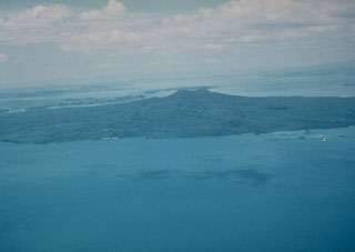 Rangitoto, a 6-km-wide island seen here from the NW, is the youngest feature of New Zealand's Auckland Volcanic Field. The volcano erupted at least twice, about 620 and 570 years ago, and is capped by a scoria cone containing a deep crater.
Photo by Jim Cole (University of Canterbury).
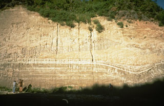 This thick outcrop exposes deposits of the 1,800-year-old Taupo eruption, one of the world's largest during the past 10,000 years. The Taupo eruption produced phreatomagmatic surge deposits, Plinian tephra deposits, and the overlying Taupo ignimbrite, seen at the upper half of this photo above the thin, light-colored layers. The eruption occurred from a vent at Horomatangi Reefs, now submerged beneath Lake Taupo.
Photo by Richard Waitt, 1986 (U.S. Geological Survey).
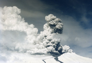 A gas-and-steam plume rises above the Ruapehu Te Wai ā-Moe (Crater Lake) during Surtseyan activity in September 1995 with two lahar deposits down the Whakapapa ski field on the northern flank. By early October almost all of the crater lake water had been removed.
Photo by John A Krippner, 1995.
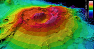 A bathymetric map was made during a 2009 voyage on the research vessel R/V Thompson of Rumble II West submarine volcano. Located NW of Rumble II East, Rumble II West, with a summit depth of 1,200 m, is the deepest of the Rumble group of seamounts, but displays evidence of hydrothermal activity. It contains a 2.5-3 km wide summit caldera about 200 m deep with a central cone. Recent lava flows originating from near the caldera rim with little or no sediment cover are on the S flanks.
Photo courtesy of New Zealand Institute of Geology and Nuclear Sciences, 2009.
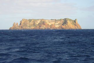 Flat-topped Curtis Island, seen here from the N, is, along with nearby Cheeseman Island, the uplifted portion of a submarine volcano astride the Kermadec Ridge. The small Pleistocene island contains abundant andesitic pyroclastic flow deposits. Reports of possible historical eruptions probably represent increased thermal activity from a shallow crater near sea level. Geologic studies have documented uplift of 18 m at Curtis during the past 200 years.
Photo by Owen Calder, 2004
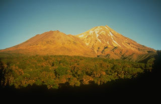 Taranaki, seen here from the SW, rises above the Taranaki ring plain, with Fanthams Peak on the left. It is the youngest and SE-most of a group of volcanoes beginning with the Kaitoke Range, near the W coast of North Island. Its most recent activity, during the 15th to 19th centuries, included the eruption of ash plumes, pyroclastic flows that traveled to the NW, and emplacement of the summit lava dome.
Photo by Chris Newhall, 1986 (U.S. Geological Survey).
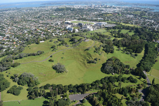 The One Tree Hill or Maungakiekie scoria cone has several summit craters and formed extensive lava flows during one of the larger eruptions of the Auckland Volcanic Field. This 2018 view is looking towards the SE with the Auckland city center in the background.
Photo by Bruce Hayward, 2018.
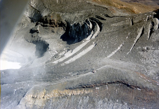 The 1995-96 eruption of Ruapehu ejected much of the water from Te Wai ā-Moe (Crater Lake), with the remaining lake to the left. The lake emptied in 1995 and was reestablished in 1996. Dome Shelter is above the northern crater rim, to the left of the lake in this view, surrounded by ash and other ejecta deposited during the eruption.
Photo by John A Krippner, 1995-1996.
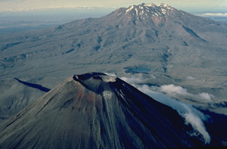 Two New Zealand volcanoes, the symmetrical Ngāuruhoe in the foreground and the massive Ruapehu in the background, are stratovolcanoes with dramatically different profiles. The steep-sided cone of Ngāuruhoe was formed during the past 2500 years by repeated eruptions from a single central conduit. The broad, elongated Ruapehu is a complex volcano that was formed by eruptions over a much longer period of time that constructed at least four overlapping volcanic edifices.
Copyrighted photo by Katia and Maurice Krafft, 1986.
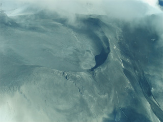 Surtseyan deposits from the 25 September 2007 Ruapehu eruption are seen here across Central Crater and the northern flank. In the lower part of the image is the ballistic apron, where blocks up to 2 m in diameter landed more than 2 km from their source. The northern flank lahar is to the lower right.
Photo by Janine Krippner, 2007.
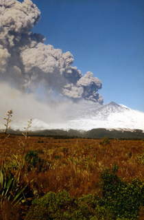 An ash plume erupts from the Ruapehu South Crater during the 1995-96 eruption, depositing ash across the flank. Ash was emplaced across a narrow swath on the NE North Island of New Zealand, out over the Pacific Ocean. This caused disruptions to water and power supplies and damage to the agricultural industry, with a cost of over $130 million New Zealand dollars to the tourism industry.
Photo by John A Krippner, 1995-1996.
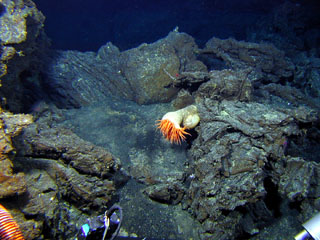 A sea anemone on relatively young lava flows at Volcano W. This view was taken on the SE cone of the two submarine volcanoes at this location identified by a 2005 New Zealand-American expedition to study submarine vents in the Kermadec arc.
Image courtesy of New Zealand-American Submarine Ring of Fire 2005 Exploration, NOAA Vents Program.
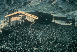 A restaurant at the Whakapapa ski area on the upper flanks of Ruapehu volcano was damaged by a lahar that originated from an explosive eruption on 22 June 1969. The lahar was produced by hot water ejected from the Crater Lake vent and snowpack around the crater that was melted by pyroclastic surges and hot tephra.
Photo by Lloyd Homer (New Zealand Geological Survey).
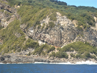 Mayor Island (Tuhua) is the top of a 700-m-high volcano with a 3-km-wide caldera forming much of the surface. Lava domes and flows have been emplaced across the island, with those seen here interbedded with obsidian layers.
Photo by Janine Krippner, 2007.
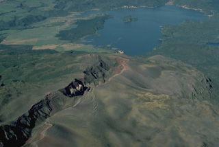 Eruptive fissures can follow the direction of regional faults, such as this New Zealand fissure that cuts diagonally across the photo. The 8-km-long fissure continues beneath the lake and was the source of a major explosive eruption in 1886 from Tarawera volcano. Most commonly, fissure vents extend radially down the flanks of a volcano from its summit. In some cases, circumferential fissures open around the rim of a volcanic caldera.
Copyrighted photo by Katia and Maurice Krafft, 1986.
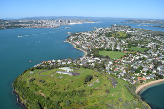 North Head or Maungauika is a scoria cone and tuff ring that formed in the Auckland Volcanic Field around 87 ka. This 2018 view from the east shows the Mount Victoria or Takarunga scoria cone to the upper right and the Auckland city center to the upper left.
Photo by Bruce Hayward, 2018.
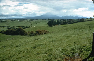 The pasture-covered, hilly terrain in the foreground is part of a vast ring plain of debris avalanche and lahar deposits surrounding Mount Taranaki. Repetitive collapse of the volcano during the late Pleistocene and Holocene produced debris avalanches that reached the W coast, nearly 40 km away.
Photo by Dan Miller (U.S. Geological Survey).
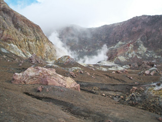 This photo looks towards the western crater lake at Whakaari/White Island, which is emitting volcanic gases and steam. The crater walls expose lavas and tuff deposits, and across the central crater floor (foreground) are blocks and hummocks of the 1912 debris avalanche deposit.
Photo by Janine Krippner, 2005.
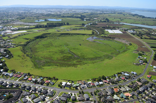 Pūkaki Lagoon or Te Pūkaki Tapu-o-Poutukeka is a maar crater within the Auckland Volcanic Field, seen here in 2018.
Photo by Bruce Hayward, 2018.
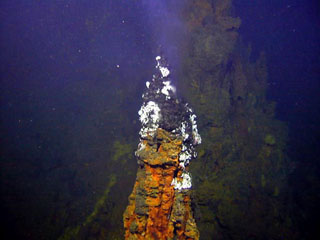 Submarine hydrothermal activity occurs at Brothers volcano, as seen here at this tall (up to 4 m high), active black smoker chimney, which is part of a large field of vents on the NW caldera wall. The oval-shaped caldera is 3-3.5 km wide and contains a post-caldera lava dome constructed on the S caldera floor.
Image courtesy of New Zealand-American Submarine Ring of Fire 2005 Exploration, NOAA Vents Program.
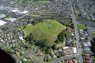 Mount Roskill or Pukewīwī / Puketāpapa is one of around 53 volcanic centers in the Auckland Volcanic field, seen here in 2018 from the south. The scoria cone was a source of lava flows around 100 ka.
Photo by Bruce Hayward, 2018.
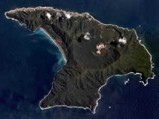 Raoul Island in the Kermadec Islands has two main calderas, one in the center of the island (Raoul Caldera) and one forming the linear western shoreline (Denham Caldera), shown in this November 2019 Planet Labs satellite image monthly mosaic (N is at the top; this image is approximately 11 km across). The Blue (upper) and Green (lower) lakes are within Raoul Caldera, with the 1964 crater along the NW edge of the Green Lake.
Satellite image courtesy of Planet Labs Inc., 2019 (https://www.planet.com/).
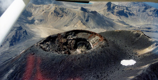 The scoria cone within the summit crater of Tongariro’s Ngāuruhoe cone formed during the 1954-75 eruptions. The majority of the cone formed during 1954-55 with the red unit at the top (along the right rim of the crater in this view) forming during the 1974-75 eruption. The outer crater rim is to the right. The northeastern part of the Tongariro volcanic complex is in the background, with Blue Lake visible at the top of the photo.
Photo by John A Krippner, 1995-1996.
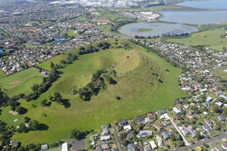 Mangere Mountain is a monogenetic cone within the Auckland Volcanic Field with spatter and scoria components, and several craters with extensive lava flows. The Mangere Lagoon tuff ring is to the upper right in this 2018 view from the NE.
Photo by Bruce Hayward, 2018.
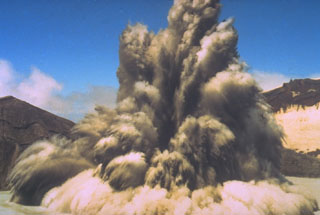 The interaction of magma and water can produce strong phreatic (steam-driven) explosions, such as in this 1980 photo of New Zealand's Ruapehu volcano. Ash and steam trail from large ejected blocks in the eruption column. Pyroclastic surge can be seen traveling radially along the surface of a crater lake. Phreatic or phreatomagmatic explosions are common at submarine volcanoes, crater lakes, and other places where hot magma (or associated gases) encounters surface water or groundwater.
Photo by Hollick, 1980, courtesy of Bruce Houghton (Wairakei Research Center).
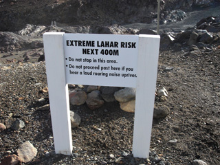 This “extreme lahar risk” sign is on the northern side of the Whangaehu valley on the E flank of Ruapehu with the September 2007 lahar in the background, the second lahar down this path that year. The bridge visible beyond the sign was damaged by the lahars.
Photo by Janine Krippner, 2007.
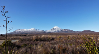 Eruptions of the Tongariro have occurred across at least 12 vents, with the western flank of the complex seen here in 2012. From left to right are the broad North Crater, the Ngāuruhoe cone, Pukekaikiore, and Pukeonake. Eruption deposits and material that has eroded from the edifice forms the plain in the foreground.
Photo by Janine Krippner, 2012.
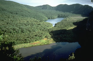 The caldera wall at the upper right was created during the youngest caldera-forming eruption of Mayor Island about 6,300 years ago. Major explosive eruptions at this time produced more than 1 km3 of tephra that deposited across the Bay of Plenty in the North Island. The 2.2 x 2.5 km wide caldera was subsequently partially filled by lava flows and domes, the latest of which may have been erupted as recently as 500-1,000 years ago.
Photo by Richard Waitt, 1986 (U.S. Geological Survey).
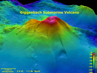 Giggenbach submarine volcano viewed from the E in this aerial oblique view with two times vertical exaggeration. Depths range from 75 to 1,600 m in this image and the resolution of the bathymetry data is 25 m. Giggenbach is ~30 km NW of the center of Macauley caldera. The bathymetry data are courtesy of the New Zealand National Institute of Water and Atmospheric Research (NIWA).
Image courtesy of New Zealand-American Submarine Ring of Fire 2005 Exploration, NOAA Vents Program.
 The 1886 Tarawera eruptive fissure, seen from the N, formed across lava domes of the 800-year-old Kaharoa eruption. The red and black rocks of the 1886 eruption, 20-30 m thick here, overlie white rhyolitic Kaharoa eruption deposits. This view shows a 2-km-long section of the 8-km en-echelon fissure with gray rocks of the Ruawahia lava dome appearing at the far end.
Photo by Bruce Houghton (Wairakei Research Center).
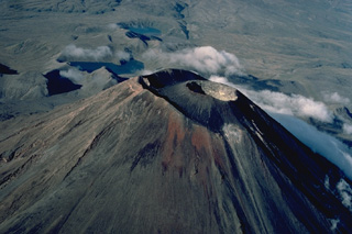 Symmetrical Ngāuruhoe volcano, seen here in an aerial view from the NE, contains a compound summit crater. The most recent eruptions have occurred from the crater of a small cinder cone that was constructed within the outer summit crater beginning in 1954. Ngāuruhoe is one of New Zealand's most active volcanoes; frequent changes in the morphology of the summit crater have been documented during historical eruptions. The two lakes in the background are the Tama Lakes, flank vents of Ruapehu volcano.
Copyrighted photo by Katia and Maurice Krafft, 1986.
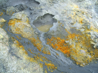 Whakaari/White Island has an active hydrothermal system that produces hot springs, fumaroles, mud pools, and acid streams and lakes. A sulfur-rich hot spring is shown here with extensive mineralization across the surrounding surface.
Photo by Janine Krippner, 2005.
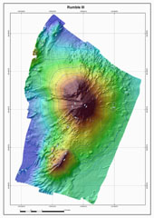 The Rumble III seamount, the largest of the Rumbles group along the South Kermadec Ridge, rises 2,300 m from the sea floor to within about 200 m of the sea surface. Edifice collapse has left a large horseshoe-shaped scar breached to the W. Fresh-looking andesitic rocks have been dredged from its summit and basaltic lava from its flanks. Rumble III has been the source of several submarine eruptions detected by hydrophone signals.
Courtesy of Ian Wright (National Institute of Water and Atmospheric Research (NIWA), Wellington, New Zealand).
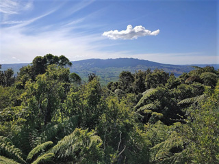 The western flank of the Pleistocene Maungatautari is seen here from Pirongia to the W in 2021.
 Photo by Janine Krippner, 2021.
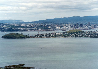 New Zealand's largest city, Auckland / Tamaki Makaurau, is built on the 600 km2 Auckland Volcanic Field. This view looking SW from the summit of Rangitoto volcano shows cones on a peninsula extending into Waitemata Harbor with the city center behind it. North Head (left) and Mount Victoria (right) on the peninsula are two of the more than 50 maars, tuff rings, and scoria cones that have formed in the past 193,000 years. Rangitoto is the only known Holocene volcano.
Photo by Ichio Moriya (Kanazawa University).
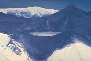 A major phreatomagmatic explosion on 22 June 1969 ejected ash and mud onto the area around Ruapehu's Crater Lake. The hot lake water along with snow melted by pyroclastic surges produced lahars that traveled down the four major valleys below the volcano. At the time, the brief eruption was the largest at Ruapehu since 1945 and lasted two and half hours. Ash-blackened Mitre Peak is at the top right, with the W rim of Crater Lake in the foreground.
Photo by Jim Cole, 1969 (University of Canterbury).
 Steam rises from the crater of White Island (also called Whakaari), one of the most active volcanoes of New Zealand. The small, uninhabited 2 x 2.4-km-wide island lies 50 km NE of the North Island. Frequent small-to-moderate explosive eruptions have been recorded since 1826, and Maori legends record earlier eruptions. This view from the SE shows the two overlapping 0.4 x 1.2 km wide craters at the summit of the largely submerged volcano.
Copyrighted photo by Stephen O'Meara.
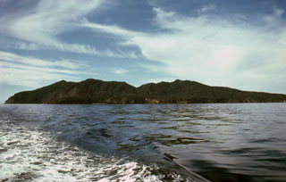 Mayor Island in the Bay of Plenty is seen here from the W. The low, 4-km-wide island, also known as Tuhua, is the summit of the broad 15-km-wide volcano. A 3-km-wide caldera formed during two or three collapse events, the latest of which followed a major explosive eruption about 6,300 years ago. Mayor Island was recognized as an active volcano only within the past two decades. Its latest eruption may have occurred only 500-1,000 years ago.
Photo by Malcolm Buck, 1980.
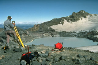 New Zealand volcanologist Brad Scott conducts theodolite (detecting height changes) measurements at Ruapehu’s Crater Lake in 1988. Measurements of the lake height, temperature, and chemistry are made routinely, and along with seismic instrumentation, are used to help forecast future activity of the volcano. Intermittent steam explosions from beneath the lake have produced lahars, which have damaged ski facilities on the upper flanks and structures in valleys below the volcano.
Photo by Don Swanson, 1984 (U.S. Geological Survey).
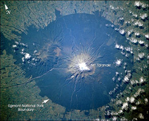 Mount Taranaki is the centerpiece of Egmont National Park on the W side of the North Island of New Zealand. Farmlands surrounding the volcano extend to the boundaries of the national park, leaving a circular pattern prominent from space. The Pleistocene Kaitoke Range forms the topographic high to the WNW.
NASA Space Shuttle image STS110-726-6, 2002 (http://eol.jsc.nasa.gov/).
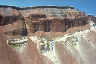 The SE part of the fissure within Ruawahia crater reveals stratigraphy from the circa 700 BP Kaharoa and 1886 CE eruptions. The 35-m-thick light-colored Kaharoa Plinian deposits at the base are largely obscured by talus fans of scoria from above. The thick overlying bright red scoria is from phase 2 of the 1886 eruption. Above it is a thin black zone (phase 3) consisting of very widespread scoria. Phase 4 (at the top) consists of white rhyolitic blocks ripped off the walls during the vent widening in the last half hour of the 10 June 1886 eruption.
Photo by Bruce Houghton (Wairakei Research Center).
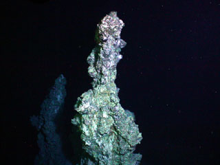 Diffuse hydrothermal venting and sulfide chimneys were observed near the summit of Clark volcano during a New Zealand-American NOAA Vents Program expedition in 2005. Hot water (221°C, 430°F) was sampled at the base of this sulfide chimney, which is almost 6 m high. Clark submarine volcano lies near the lower end of the Southern Kermadec Arc and is the southernmost volcano of the submarine chain that displays known hydrothermal activity.
Image courtesy of New Zealand-American Submarine Ring of Fire 2005 Exploration, NOAA Vents Program.
This is a compilation of New Zealand volcano information sources, such as official monitoring or other government agencies.
| Volcano Observatories | |
|---|---|
| GeoNet | |
| - GeoNet Volcanic Activity Bulletins | |
| - GeoNet Alert Levels | |
| Additional Information Sources | |
|---|---|
| New Zealand Police | |
| Volcanic Ash Advisory Center | |
|---|---|
| Wellington Volcanic Ash Advisory Center (VAAC) | |
| - Wellington VAAC Notices | |