Theme Collections | Planet Labs Imagery
Theme collections are galleries not specifically related to volcanic hazards, processes, research, types, or features. This includes subjects such as different satellite platforms, astronaut photos from the Space Shuttle, specific photographers, or other special collections.
Image Gallery for Planet Labs Imagery
This gallery presents satellite images of volcanoes made available by Planet Inc. (https://www.planet.com/) through a partnership agreement with the Smithsonian Institution. As they note “On average, Planet has 1300 images of every place on earth. This is an unprecedented dataset - we’re creating a global, near-daily stream of satellite imagery that can be fed into a variety of workflows for commercial and humanitarian applications, enabling an ecosystem of apps and services.” The availability of this imagery to GVP, both for this gallery and for describing recent activity in Bulletin reports, benefits the science of volcanology and hazard awareness. There are 372 images available.
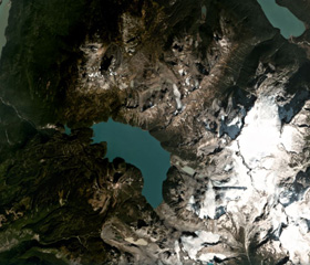
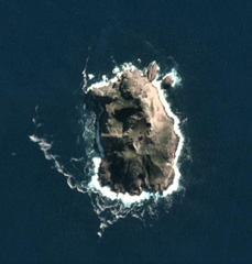
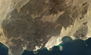
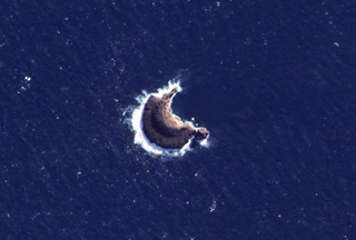 The 1-km-wide (maximum E-W direction) Leskov Island is shown in this 19 March 2021 PlanetScope satellite image (N is at the top). The island is the surface manifestation of a seamount chain that extends 60 km SW of Zavodovski in the South Sandwich Islands and is the smallest of the island group. The island coastline is entirely cliffs and it is constructed of eroded lava flows.
Satellite image courtesy of Planet Labs Inc., 2021 (https://www.planet.com/).
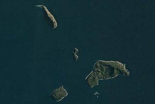
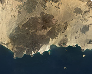
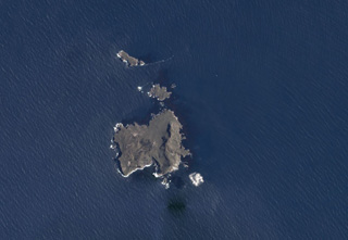 The roughly 2-km-wide, 3 km2 Nightingale (lower), Middle, and Stoltenhoff (top) islands in the South Atlantic Ocean are shown in this January 2018 Planet Labs satellite image monthly mosaic (N is at the top). The heavily eroded Island is the southernmost of the Tristan da Cunha group, and a submarine eruption occurred in 2004.
Satellite image courtesy of Planet Labs Inc., 2018 (https://www.planet.com/).
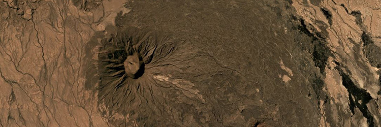
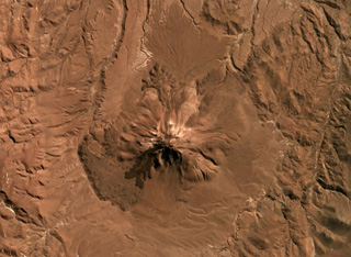
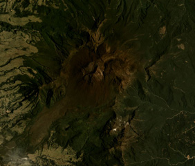
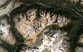
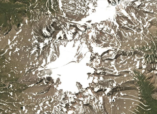
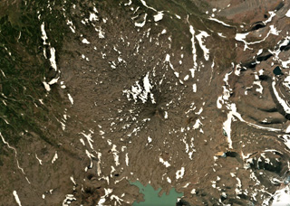
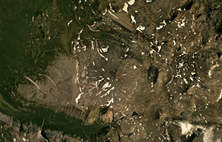
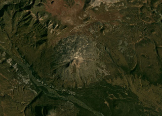
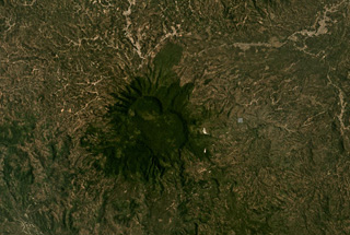
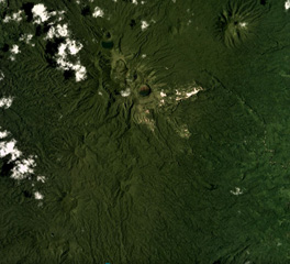
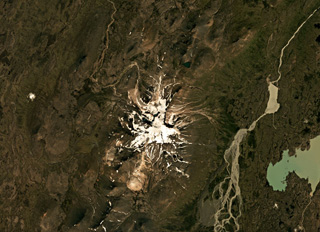 Snæfell (Snaefell) is comprised of a main edifice with NE-SW-trending fissures extending out to 10-18 km, with the former shown in this August 2019 Planet Labs satellite image monthly mosaic (N is at the top; this image is approximately 21 km across). An ice cap across the summit reaches a few tens of meters thick.
Satellite image courtesy of Planet Labs Inc., 2019 (https://www.planet.com/).
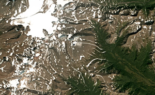
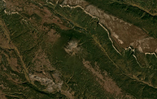
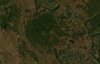
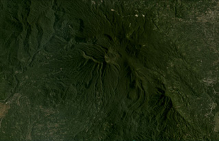
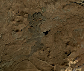
 Heiðarsporðar (Heidarspordar) is about 22 km in length, with a smaller area shown in this June 2019 Planet Labs satellite image monthly mosaic (N is at the top; this image is approximately 20 km across). Around 2,200 years ago it produced a lava field around 220 km2 in size, reaching 60 km away from the source. The darker area in the upper left corner is Mývatn lake.
Satellite image courtesy of Planet Labs Inc., 2019 (https://www.planet.com/).
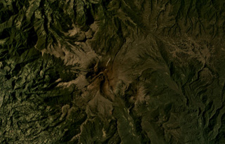
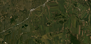
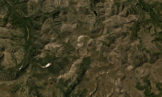
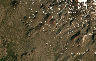
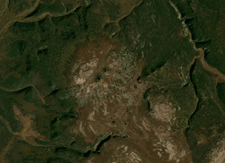
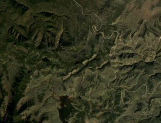
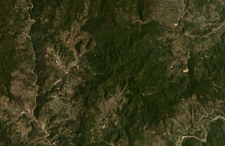
 Scoria cones of the Meullín volcanic field are across this May 2018 Planet Labs satellite image monthly mosaic (N is at the top; this image is approximately 8.5 km across). The field is located in southern Chile and the small cones are vegetated, many with visible summit craters.
Satellite image courtesy of Planet Labs Inc., 2018 (https://www.planet.com/).
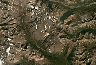
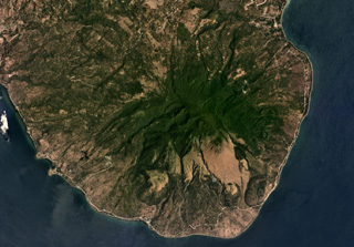
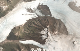 Amalia Glacier flows around the northern flank of Reclus in the Southern Patagonia Ice Field, shown in this 27 February 2018 PlanetScope satellite image (N is at the top; this image is approximately 8 km across). The flanks are heavily eroded and there is a landslide deposit from the northern flank on the glacier surface.
Satellite image courtesy of Planet Labs Inc., 2018 (https://www.planet.com/).
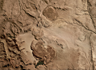
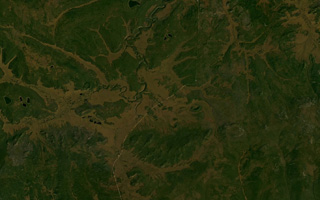
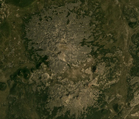
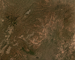
 The Crater Basalt Volcanic Field in Argentina covers around 700 km2, with a portion of the field shown in this July 2019 Planet Labs satellite image monthly mosaic (N is at the top; this image is approximately 33 km across). There are at least nine scoria cones across the field as well as the mostly pahoehoe lava flows reaching out to 5 km.
Satellite image courtesy of Planet Labs Inc., 2019 (https://www.planet.com/).
 Risco Plateado covers an area of 910 km2 and has a steep mountainous relief partly due to glacial erosion, shown in this February 2021 Planet Labs satellite image monthly mosaic (N is at the top; this image is approximately 15 km across). there is a scoria cone on the SE flank, visible in the lower right corner of the image.
Satellite image courtesy of Planet Labs Inc., 2021 (https://www.planet.com/).
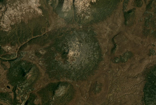
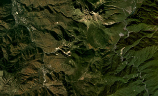
 The Tipas volcanic complex is located in Argentina and is shown in this September 2019 Planet Labs satellite image monthly mosaic (N is at the top; this image is approximately 10 km across). The complex spans 25 km2 and consists of craters, cones, lava domes and flows.
Satellite image courtesy of Planet Labs Inc., 2021 (https://www.planet.com/).
 This unnamed scoria cone near the Chile/Argentina border has produced lava flows to the east, visible in this July 2019 Planet Labs satellite image Monthly Mosaic (N is at the top; this image is approximately 8.5 km across). The visible flows have clear lobate or broader flow boundaries, levees, and pressure ridges, while other lavas have been buried by sand deposits.
Satellite image courtesy of Planet Labs Inc., 2019 (https://www.planet.com/).
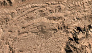
 Tuzgle volcano is located in the Puna Plateau, NW Argentina, shown in this July 2019 Planet Labs satellite image monthly mosaic (N is at the top; this image is approximately 20 km across). The flanks are composed of lava flows radially emplaced from the summit, with the youngest flow on the SW and upper N and S flanks, and additional younger flows on the northern and E flanks.
Satellite image courtesy of Planet Labs Inc., 2019 (https://www.planet.com/).
 Several lava domes and flows or coulees of the Jatun Mundo Quri Warani complex (also known as Nuevo Mundo) in Bolivia are shown in this July 2019 Planet Labs satellite image monthly mosaic (N is at the top; this image is approximately 23 km across).
Satellite image courtesy of Planet Labs Inc., 2019 (https://www.planet.com/).
 The two maars of the Laguna Jayu Khota group in Bolivia are shown in this June 2019 Planet Labs satellite image monthly mosaic (N is at the top; this image is approximately 10 km across). The Laguna Jayu Khota maar is near the center of the image and the Nehke Khota maar is on the southern side of the road near the lower left corner.
Satellite image courtesy of Planet Labs Inc., 2019 (https://www.planet.com/).
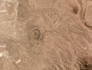
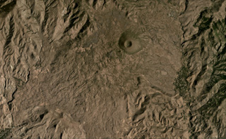
 The isolated Cerro Nicholson scoria cone in Peru is shown in this July 2019 Planet Labs satellite image monthly mosaic (N is at the top; this image is approximately 6 km across). The monogenetic cone has a summit crater with a diameter of around 200 m.
Satellite image courtesy of Planet Labs Inc., 2019 (https://www.planet.com/).
 The Doña Juana complex in Colombia is shown in this September 2017 Planet Labs satellite image monthly mosaic (N is at the top; this image is approximately 8 km across). The summit area is shaped by a large scarp that has been infilled by lava domes, which have subsequently undergone collapse events to produce block-and-ash flow deposits.
Satellite image courtesy of Planet Labs Inc., 2017 (https://www.planet.com/).
 Sotará in Colombia is shown in the center of this February 2020 Planet Labs satellite image monthly mosaic (N is at the top; this image is approximately 19 km across). The edifice formed within a 4.5-km-diameter caldera and has a collapse scarp open towards the SW, as well as several lava domes in the summit area. Thick lava flows and domes have been emplaced within the scarp.
Satellite image courtesy of Planet Labs Inc., 2020 (https://www.planet.com/).
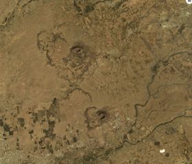
 The Red Hill-Quemado Volcanic Field in New Mexico, USA, contains more than 40 scoria cones, some of which are in the area shown in this August 2019 Planet Labs satellite image monthly mosaic (N is at the top; this image is approximately 34 km across). There are also phreatomagmatic features including the 2-km-wide Zuni Salt Lake maar at the top of this Planet Labs satellite image monthly mosaic (N is at the top; this image is approximately 69 km across).
Satellite image courtesy of Planet Labs Inc., 2019 (https://www.planet.com/).
 The heavily eroded Cayley Volcanic Field in SW Canada is the N-S trending ridge down the center of this August 2019 Planet Labs satellite image monthly mosaic (N is at the top; this image is approximately 69 km across). The complex is composed of different eruption centers including lava domes, cones, and glaciovolcanic features, and has also been shaped by large flank collapse events.
Satellite image courtesy of Planet Labs Inc., 2019 (https://www.planet.com/).
 Garibaldi Lake is a group of nine cones around the lake in the center of this October 2020 Planet Labs satellite image monthly mosaic (N is at the top; this image is approximately 16.5 km across). The three cones SW of the lake center are Price Bay, Mount Price, and Clinker Peak. The Black Husk is the dark cone about 2.5-3 km N of the upper part of the lake, and The Cinder Cone is 2.5 km SE of that.
Satellite image courtesy of Planet Labs Inc., 2020 (https://www.planet.com/).
 The Bridge River cones group is within the Garibaldi Volcanic Belt in SW Canada and is shown in the center of this September 2020 Planet Labs satellite image monthly mosaic (N is at the top; this image is approximately 22 km across). Younger lava flows that are potentially post-glaciation are present N of Bridge River.
Satellite image courtesy of Planet Labs Inc., 2020 (https://www.planet.com/).
 Silverthrone volcano in SW British Columbia, Canada, is below the glaciers in the center of this September 2018 Planet Labs satellite image monthly mosaic (N is at the top; this image is approximately 150 km across). It is a roughly 20-km-wide eroded caldera complex containing lava domes and flows.
Satellite image courtesy of Planet Labs Inc., 2018 (https://www.planet.com/).
 The Heart Peaks volcanic center in Canada is down the center of this September 2019 Planet Labs satellite image monthly mosaic (N is at the top; this image is approximately 58 km across). The volcano was constructed through lava flow emplacement, then lava dome growth to form the summit ridge.
Satellite image courtesy of Planet Labs Inc., 2019 (https://www.planet.com/).
 Several cones of the Keluo Group are shown in this September 2019 Planet Labs satellite image monthly mosaic (N is at the top; this image is approximately 22 km across). The volcanic field is located in NE China, and is NW of the Wudalianchi volcanic field.
Satellite image courtesy of Planet Labs Inc., 2018 (https://www.planet.com/).
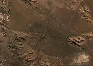
 The Arxan-Chaihe volcanic field covers around 2,000 km2 with at least 47 identified vents, some of which can be seen in a NE-SW trend through the center of this September 2019 Planet Labs satellite image monthly mosaic (N is at the top; this image is approximately 69 km across). As well as eruptions producing spatter cones and lava flows, there are phreatomagmatic vents and fissure-controlled vents.
Satellite image courtesy of Planet Labs Inc., 2018 (https://www.planet.com/).
 A portion of the Arxan-Chaihe volcanic field spanning approximately 32 km across is shown in this September 2018 Planet Labs satellite image monthly mosaic (N is at the top; this image is approximately 32 km across). There is a NE-SW trend of scoria cones, craters, and maars across the image, including Aershan just north of Tianchizhen town (in the western side of the image), the smaller Dichi lake to the E, the larger Shihaopendi complex crater near the center of this image, and Yanshan and Gaoshan NE of there.
Satellite image courtesy of Planet Labs Inc., 2018 (https://www.planet.com/).
 Several cones and craters of the Honggeertu volcanic field in the Nei Mongol Province are shown across this August 2019 Planet Labs satellite image monthly mosaic (N is at the top; this image is approximately 11 km across). The cones are across a NE-SW trend and several have summit craters up to 200 m in diameter.
Satellite image courtesy of Planet Labs Inc., 2019 (https://www.planet.com/).
 The Vitim Volcanic Field covers an area of around 4,500 km2. A smaller area approximately 34 km across that contains several craters is shown in this August 2019 Planet Labs satellite image monthly mosaic (N is at the top). The field is located about 200 km E of northern Lake Baikal, along the Vitim River. The majority of the eruption centers are in the NW portion of the field.
Satellite image courtesy of Planet Labs Inc., 2019 (https://www.planet.com/).
 The Udokan Plateau volcanic field extends across 3,000 km2 around 400 km ENE of the northern tip of Lake Baikal, with a small part of the field that contains Holocene features shown in this July 2019 Planet Labs satellite image monthly mosaic (N is at the top; this image is approximately 16.5 km across). The round, 950-m-diameter lava dome in the center of this image is just SW of the Aku crater. Chepe cone is in the NW corner, and between them is Dolinnyi cone.
Satellite image courtesy of Planet Labs Inc., 2019 (https://www.planet.com/).
 The Iettunup complex is comprised of two main edifices, Lamutsky just below the center of this image, and Iettunup to its NW, both shown in this September 2019 Planet Labs satellite image monthly mosaic (N is at the top; this image is approximately 24 km across).
Satellite image courtesy of Planet Labs Inc., 2019 (https://www.planet.com/).
 Iktunup volcano in the northern Sredinny Range of Kamchatka is in the center of this Planet Labs satellite image monthly mosaic (N is at the top; this image is approximately 14 km across). The smaller complex cone on the western flank is Tunipilyakum.
Satellite image courtesy of Planet Labs Inc., 2019 (https://www.planet.com/).
 A glacier near the summit of Bely volcano flows down the western flank, shown in this 7 August 2020 PlanetScope satellite image (N is at the top; this image is approximately 21 km across). In relation to the glacier head, to the NW is the Bely cone, NE is Keveneytunup cone, NEE is the Lagerny cone, and SW is Sergeeva, all parts of the Bely complex. The smoother area to the SE with a small crater is Kaileney volcano.
Satellite image courtesy of Planet Labs Inc., 2020 (https://www.planet.com/).
 Kaileney is located in northern Kamchatka and is shown in this August 2019 Planet Labs satellite image monthly mosaic (N is at the top; this image is approximately 27 km across). The northern flank has undergone extensive glacial erosion, and two small cones are on the summit area.
Satellite image courtesy of Planet Labs Inc., 2018 (https://www.planet.com/).
 Uka volcano is in the center of this August 2019 Planet Labs satellite image monthly mosaic (N is at the top; this image is approximately 14 km across). It is located E of Alngey volcano in the Sredinny Range, Kamchatka.
Satellite image courtesy of Planet Labs Inc., 2019 (https://www.planet.com/).
 Alngey volcano is near the center of this August 2019 Planet Labs satellite image monthly mosaic (N is at the top; this image is approximately 30 km across). The Pleistocene Kamenisty is to the SE and Uka is the cone to the E. It is part of the Sredinny Range in Kamchatka, Russia.
Satellite image courtesy of Planet Labs Inc., 2019 (https://www.planet.com/).
 Mezhdusopochny volcano is north of Lake Mezhdusopochny, and is shown in the center of this September 2018 Planet Labs satellite image monthly mosaic (N is at the top; this image is approximately 14 km across). To the E are the western flanks of Shishel.
Satellite image courtesy of Planet Labs Inc., 2018 (https://www.planet.com/).
 Several scoria cones on the Sedanka Lava Field are shown in this September 2019 Planet Labs satellite image monthly mosaic (N is at the top; this image is approximately 13 km across). The Gorny Institute volcanic complex is to the upper right and the Sredny scoria cone of Tuzovsky is to the upper left, and between them are scoria cones of Sedanka. The field has more than 100 cones across an area of around 10 km.
Satellite image courtesy of Planet Labs Inc., 2019 (https://www.planet.com/).
 The small Fedotych cone located in the Sredinny Range, Kamchatka, is in the center of this September 2019 Planet Labs satellite image monthly mosaic (N is at the top; this image is approximately 14 km across).
Satellite image courtesy of Planet Labs Inc., 2019 (https://www.planet.com/).
 Cherny is the volcano with oxidized deposits at the summit in the center of this August 2019 Planet Labs satellite image monthly mosaic (N is at the top; this image is approximately 15 km across).
Satellite image courtesy of Planet Labs Inc., 2019 (https://www.planet.com/).
 Eggella formed in the Sredinny Range, Kamchatka, and is seen in the center of this September 2019 Planet Labs satellite image monthly mosaic (N is at the top; this image is approximately 13 km across). Several small cones are visible on the eastern flank.
Satellite image courtesy of Planet Labs Inc., 2019 (https://www.planet.com/).
 Kekurny has two main edifices, the main edifice to the north, and Bunanya in the lower-center of this August 2019 Planet Labs satellite image monthly mosaic (N is at the top; this image is approximately 12 km across). From the summit of Bunanya there is a NE-SW trend of scoria cones.
Satellite image courtesy of Planet Labs Inc., 2019 (https://www.planet.com/).
 A scoria cone with a summit crater forms the apex of Krainy volcano in the Sredinny Range, Kamchatka Peninsula, in the center of this August 2017 Planet Labs satellite image monthly mosaic (N is at the top; this image is approximately 16 km across). A smaller scoria cone, also red from oxidation, is on the SW flank, beside a roughly 3-km-long lobate lava flow with visible pressure ridges.
Satellite image courtesy of Planet Labs Inc., 2017 (https://www.planet.com/).
 The Anaun edifice has several erosional ravines on the northern and western flanks that extend from the summit, seen in this September 2019 Planet Labs satellite image monthly mosaic (N is at the top; this image is approximately 15 km across). Smaller scoria cones have formed around the cone, like the one to the E with a summit crater.
Satellite image courtesy of Planet Labs Inc., 2019 (https://www.planet.com/).
 The small Geodesistoy cone has a basal diameter of around 6 km, shown in the center of this September 2019 Planet Labs satellite image monthly mosaic (N is at the top; this image is approximately 14 km across).
Satellite image courtesy of Planet Labs Inc., 2019 (https://www.planet.com/).
 Kulkev volcano has a basal diameter of around 7 km and is shown in this September 2019 Planet Labs satellite image monthly mosaic (N is at the top; this image is approximately 15 km across).
Satellite image courtesy of Planet Labs Inc., 2019 (https://www.planet.com/).
 Several cones form the summit area of Romanovka volcano in the center of this September 2019 Planet Labs satellite image monthly mosaic (N is at the top; this image is approximately 13 km across). The edifice covers an area of 24 km2 and has undergone relatively-little erosion, except for stream erosion around the lower flanks.
Satellite image courtesy of Planet Labs Inc., 2019 (https://www.planet.com/).
 A small cone forms the summit of the 72 km2 Kozyrevsky edifice, near the center of this July 2019 Planet Labs satellite image monthly mosaic (N is at the top; this image is approximately 12.5 km across). Glacial erosion has altered the lower flanks and several younger scoria cones have formed around the edifice.
Satellite image courtesy of Planet Labs Inc., 2019 (https://www.planet.com/).
 The Pleistocene Akhtang volcano in the Sredinny Range, Kamchatka, is shown in this July 2019 Planet Labs satellite image monthly mosaic (N is at the top; this image is approximately 12.5 km across). The deeply eroded edifice has W- to N-facing scarps that form the ridge across the summit area.
Satellite image courtesy of Planet Labs Inc., 2019 (https://www.planet.com/).
 Plosky volcano in the Sredinny Range, Kamchatka, is shown in this July 2019 Planet Labs satellite image monthly mosaic (N is at the top; this image is approximately 17 km across). A small cone is at the summit with a crater or scarp opening towards the NW, on top of the broad lower edifice.
Satellite image courtesy of Planet Labs Inc., 2019 (https://www.planet.com/).
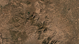
 The summit of Bolshoi Payalpan is near the center of this August 2019 Planet Labs satellite image monthly mosaic (N is at the top; this image is approximately 31 km across). Erosion has produced deep valleys across the flanks. Maly Payalpan is in the SE corner of this image.
Satellite image courtesy of Planet Labs Inc., 2019 (https://www.planet.com/).
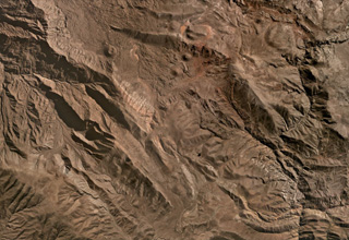
 Zavaritsky is the group of six scoria cones in the center of this August 2018 Planet Labs satellite image monthly mosaic (N is at the top; this image is approximately 17 km across). The highest cone is Mount Peschanaya towards the south. The crater of one of the cones is visible on the SE flank.
Satellite image courtesy of Planet Labs Inc., 2018 (https://www.planet.com/).
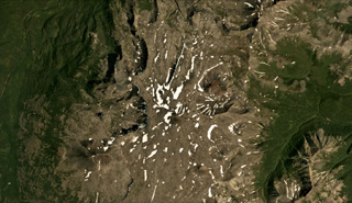
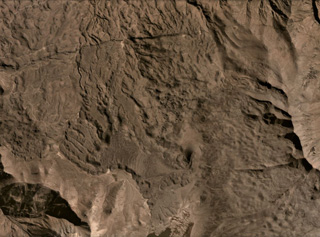
 The 25 × 15 km Karymshina caldera is located within the area shown in this September 2020 Planet Labs satellite image monthly mosaic (N is at the top; this image is approximately 33 km across). The caldera contains several ignimbrite deposits that reach at least 1-km-thick along the eastern edge.
Satellite image courtesy of Planet Labs Inc., 2019 (https://www.planet.com/).
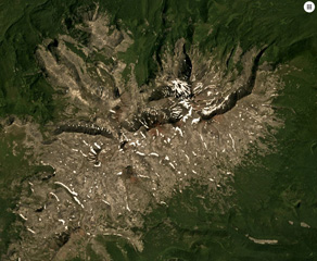
 The Barkhatnaya Sopka complex is down the center of this 30 August 2020 PlanetScope satellite image (N is at the top; this image is approximately 6.5 km across). The unvegetated cone in the N is Mt. Barkhatnaya with a lava flow to the SW, and the red exposed area on the SE end of that roughly 2-km long ridge is a scoria cone on the other side of white eroded rhyolite. Barkhatnaya Sopka is a ESE-WNW-trending ridge approximately 500-m-long near the lower center of this image. Immediately E of that is the Goryachaya Sopka with a small crater that produced the lava flows towards the E.
Satellite image courtesy of Planet Labs Inc., 2020 (https://www.planet.com/).
 The Ostanets summit is in the center of this September 2019 Planet Labs satellite image monthly mosaic (N is at the top; this image is approximately 13 km across). The morphology of a lava flow front is visible on the SW flanks.
Satellite image courtesy of Planet Labs Inc., 2019 (https://www.planet.com/).
 Piratkovsky in southern Kamchatka is just below the center of this September 2018 Planet Labs satellite image monthly mosaic (N is at the top; this image is approximately 30 km across). The northern part of the unvegetated area in the center is Perevalny, and the volcano with a summit crater to the SW is Khodutka.
Satellite image courtesy of Planet Labs Inc., 2018 (https://www.planet.com/).
 The vegetated summit of Odamoisan (also called Tebenkov) is in the center of this September 2019 Planet Labs satellite image monthly mosaic (N is at the top; this image is approximately 9 km across). South of the summit is the unvegetated Machekh crater with continuing geothermal activity. The unvegetated cone to the SW is Etorofu-Yakeyama, or the Grozny Group.
Satellite image courtesy of Planet Labs Inc., 2019 (https://www.planet.com/).
 The Tenchozan volcano is in the center of this September 2019 Planet Labs satellite image monthly mosaic (N is at the top; this image is approximately 6 km across). There are two crater chains along the summit area, the 1.8-km-long northern chain consisting of ten craters, and the 700-m-long southern chain consisting of four craters. The individual crater diameters are up to 250 m (northern chain) and 100 m (southern chain), and reach up to 70 and 30 m deep, respectively.
Satellite image courtesy of Planet Labs Inc., 2019 (https://www.planet.com/).
 Yakedake volcano is the lava dome complex to the north (with the unvegetated summit), and Akandanayama volcano is in the center of this October 2019 Planet Labs satellite image monthly mosaic (N is at the top; this image is approximately 11 km across). It is composed of lava flows, pyroclastic deposits, and a lava dome forms the summit.
Satellite image courtesy of Planet Labs Inc., 2019 (https://www.planet.com/).
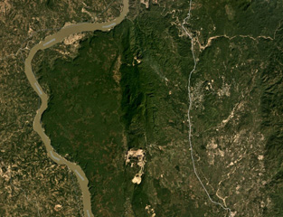 The Singu Plateau is largely comprised of lava flows, with the flow fronts along the river visible in this November 2019 Planet Labs satellite image monthly mosaic (N is at the top; this image is approximately 20 km across). The field has been offset by the Sagaing fault visible down the center of the image, and the river has been diverted around the flow front.
Satellite image courtesy of Planet Labs Inc., 2019 (https://www.planet.com/).
 The Ambalatungan Group in northern Luzon, Philippines, is in the central area of this April 2019 Planet Labs satellite image monthly mosaic (N is at the top; this image is approximately 12 km across). The complex has formed by three edifices across a nearly E-W trend, Ambalatungan, Bumabag, and Binluan that has the scarp and relatively smooth western flank near the center of this image.
Satellite image courtesy of Planet Labs Inc., 2018 (https://www.planet.com/).
 Patoc volcano in northern Luzon, Philippines, is in the center of this April 2019 Planet Labs satellite image monthly mosaic (N is at the top; this image is approximately 11.5 km across). The edifice has undergone extensive erosion and is now vegetated.
Satellite image courtesy of Planet Labs Inc., 2019 (https://www.planet.com/).
 Malindig (or Marlanga) volcano is located in southern Marinduque island, shown in this April 2019 Planet Labs satellite image monthly mosaic (N is at the top; this image is approximately 13 km across). The irregular summit shows evidence of lava dome emplacement, possible flank collapse or landslide scarps, and extensive erosion.
Satellite image courtesy of Planet Labs Inc., 2019 (https://www.planet.com/).
 Kalatungan forms the E-W trending volcanic ridge across this November 2019 Planet Labs satellite image monthly mosaic (N is at the top; this image is approximately 25 km across). Extensive erosion has formed ridge-and-gully topography across the flanks.
Satellite image courtesy of Planet Labs Inc., 2020 (https://www.planet.com/).
 The vegetated Tobaru volcano in western North Maluku, Indonesia, is in the center of this November 2019 Planet Labs satellite image monthly mosaic (N is at the top; this image is approximately 12 km across). There is a possible flank collapse scarp on the western flank.
Satellite image courtesy of Planet Labs Inc., 2019 (https://www.planet.com/).
 The eroded Sekincau Belirang edifice is shown in this September Planet Labs satellite image monthly mosaic (N is at the top; this image is approximately 21 km across). The summit area has two calderas, Belirang and Balak, and active geothermal areas appear as white areas on the eastern flank.
Satellite image courtesy of Planet Labs Inc., 2019 (https://www.planet.com/).
 Bukit Daun has a complex summit with several peaks, and a possible landslide scarp on the upper western flank, seen in this August 2020 Planet Labs satellite image monthly mosaic (N is at the top; this image is approximately 22 km across). A crater on the eastern side of the summit area contains Telapak lake and to the south is a lava flow with levees and pressure ridges visible through the vegetation.
Satellite image courtesy of Planet Labs Inc., 2020 (https://www.planet.com/).
 The Sarik cone of the Sarik-Gajah volcanic complex is near the center of this May 2019 Planet Labs satellite image monthly mosaic (N is at the top; this image is approximately 5 km across). The Gajah cone is around 6 km SW.
Satellite image courtesy of Planet Labs Inc., 2019 (https://www.planet.com/).
 Malintang volcano in Indonesia is shown in this August 2020 Planet Labs satellite image monthly mosaic (N is at the top; this image is approximately 25 km across). A crater lake is present at the summit. A large horseshoe-shaped scarp is visible down the southern flank, likely formed through flank collapse.
Satellite image courtesy of Planet Labs Inc., 2020 (https://www.planet.com/).
 The roughly 1.1 x 0.8 km Hunter Island in the SE New Hebrides arc is shown in this 14 May 2020 PlanetScope satellite image (N is at the top). Several craters have formed across the island and geothermal activity has been noted on the N, NE, and SE coasts.
Satellite image courtesy of Planet Labs Inc., 2020 (https://www.planet.com/).
 The NE Shepherd Islands group is south of Tongoa Island in Vanuatu and is shown in this 10 August 2020 PlanetScope satellite image (N is at the top). The islands are the northernmost, 2.8-km-long Ewose, Falea in the center, Tongariki to the SE, and Buninga to the SW. The islands contain outcrops of lava flows, pyroclastic deposits, and dikes.
Satellite image courtesy of Planet Labs Inc., 2020 (https://www.planet.com/).
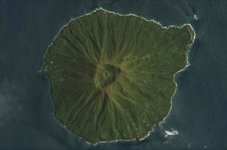 The 4-5-km-diameter Mere Lava volcano is shown in this 14 March 2021 Planet Scope satellite image (N is at the top). It has a distinct summit crater that has a scoria cone with its own summit crater inside. Erosion has formed radial valleys down the flanks.
Satellite image courtesy of Planet Labs Inc., 2021 (https://www.planet.com/).
 The Takuan Group in southern Bougainville Island, Papua New Guinea, is shown in this Planet Labs satellite image monthly mosaic (N is at the top; this image is approximately 12.5 km across). The group contains three edifices along a NW-SE trend, all of which have probable collapse scarps, and erosion on the flanks. The volcano in the center has a lava dome that has formed within the scarp.
Satellite image courtesy of Planet Labs Inc., 2018 (https://www.planet.com/).
 The vegetated Sessagara volcanic group contains several small cones, two with summit craters, seen in this Planet Labs satellite image monthly mosaic (N is at the top; this image is approximately 12 km across). The eroded topographic high to the lower right may also be a cone.
Satellite image courtesy of Planet Labs Inc., 2019 (https://www.planet.com/).
 Thirty small volcanic centers have been identified in the Managlase Plateau in SE Papua New Guinea. Some of these are shown in this July 2019 Planet Labs satellite image monthly mosaic (N is at the top; this image is approximately 13 km across). Several vegetated craters, lava domes, and cones are visible across this image, and lava flows have also been reported.
Satellite image courtesy of Planet Labs Inc., 2019 (https://www.planet.com/).
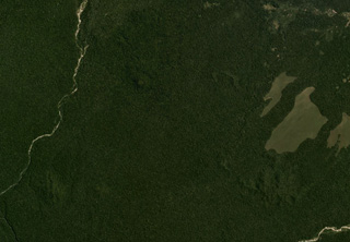
 The Ankaizina volcanic field in Northern Madagascar is in the area shown in this Planet Labs satellite image monthly mosaic (N is at the top; this image is approximately 25 km across). The largely vegetated field contains scoria cones and lava flows.
Satellite image courtesy of Planet Labs Inc., 2019 (https://www.planet.com/).
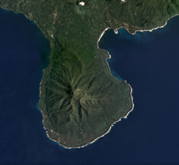
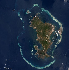 Mayotte consists two main volcanic islands, Grande Terre and Petite Terre, and around twenty islets within a barrier-reef lagoon complex approximately 38 km across, shown in this Planet Labs satellite image monthly mosaic (N is at the top). Recent activity has occurred offshore, 50 km E.
Satellite image courtesy of Planet Labs Inc., 2018 (https://www.planet.com/).
 The Bir Borhut volcanic field in southern Yemen is shown in this December 2019 Planet Labs satellite image monthly mosaic (N is at the top; this image is approximately 26 km across). The At-Tabâb maar is SE of the lava field along the coastline next to a tuff ring. Cones have formed throughout the darker lava field.
Satellite image courtesy of Planet Labs Inc., 2019 (https://www.planet.com/).
 The Bir Borhut volcanic field in southern Yemen is shown in this December 2019 Planet Labs satellite image monthly mosaic (N is at the top; this image is approximately 104 km across). The field contains scoria cones, tuff rings and cones, mars, and lava flows. The At-Tabâb maar is SE of the lava field along the coastline.
Satellite image courtesy of Planet Labs Inc., 2019 (https://www.planet.com/).
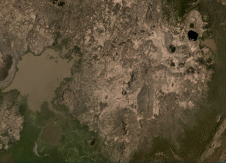
 The Harra es-Sawâd (or Shuqra) volcanic field covers an area nearly 100 km across the Southern Yemen along the Gulf of Aden, shown in this December 2019 Planet Labs satellite image monthly mosaic (N is at the top; this image is approximately 104 km across). There are around 100 identified cones, and a lava field that covers an area of 40 x 95 km.
Satellite image courtesy of Planet Labs Inc., 2019 (https://www.planet.com/).
 The Harras of Dhamar volcanic field is shown in this December 2019 Planet Labs satellite image monthly mosaic (N is at the top; this image is approximately 51 km across). The field contains many scoria cones and associated lava flows, with some older obsidian lava flows. Many of the cones have amphitheater-shaped craters due to flank collapse or rafting.
Satellite image courtesy of Planet Labs Inc., 2019 (https://www.planet.com/).
 The Jabal Haylan volcanic field comprises scoria cones and tuff rings and associated lava flows across a 75-km-long area, with a portion of the field shown in this Planet Labs satellite image monthly mosaic (N is at the top; this image is approximately 52 km across). The chain crosses a NW-SE-trending fault that with visible offset in this image. Many of the cones and rings have experienced flank collapse, rafting, or erosion, leaving amphitheater-shaped craters. Some tuff rings appear to have lava domes that have formed within the crater.
Satellite image courtesy of Planet Labs Inc., 2019 (https://www.planet.com/).
 An eroded scoria cone of Jabal el-Marha is near the center of this January 2019 Planet Labs satellite image monthly mosaic (N is at the top; this image is approximately 5 km across). The underlying lava flow morphology is visible, especially along the NW of the image, and reached around 2 km from the cone.
Satellite image courtesy of Planet Labs Inc., 2019 (https://www.planet.com/).
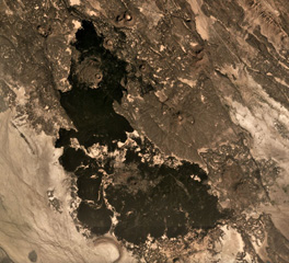
 The 1,500 km2 Harra of Arhab volcanic field is shown down the center of this December 2019 Planet Labs satellite image monthly mosaic (N is at the top; this image is approximately 76 km across). Approximately 60 cones are throughout the field; recent, darker lava flows are visible near the center of this image.
Satellite image courtesy of Planet Labs Inc., 2019 (https://www.planet.com/).
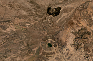
 Part of the 1,500 km2 Harra of Arhab volcanic field is shown in this December 2019 Planet Labs satellite image monthly mosaic (N is at the top; this image is approximately 20 km across). Lava flows from recent eruptions of Kaulet Hattab and Jabal Zebib cones are darker, with the later producing the nearly 9-km-long lava flow to the south. Many of the scoria cones underwent flank collapse or rafting during eruptions and have horseshoe-shaped craters as a result.
Satellite image courtesy of Planet Labs Inc., 2019 (https://www.planet.com/).
 Two scoria cones of the Jabal Yar volcanic center in SW Saudi Arabia are sown in this December 2019 Planet Labs satellite image monthly mosaic (N is at the top; this image is approximately 19 km across). There are three groups of cones and this is the northernmost 'Ukwatain group. Both cones underwent flank collapse or rafting during their eruptions and now open towards the W. Lava flow boundaries are visible on the western side of both cones.
Satellite image courtesy of Planet Labs Inc., 2019 (https://www.planet.com/).
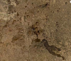
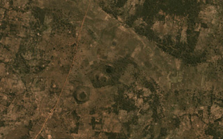 The Igwisi Hills volcanic complex contains the three kimberlite cones in the center of this November 2019 Planet Labs satellite image monthly mosaic (N is at the top; this image is approximately 3.5 km across). From the NE to SW, the three cones are NE Volcano, Central Volcano, and SW Volcano. Each cone produced viscous lavas that reached short distances from the vents.
Satellite image courtesy of Planet Labs Inc., 2020 (https://www.planet.com/).
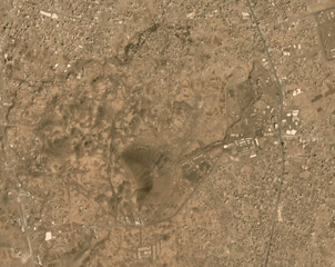
 Chiracha is a rhyolite volcano in Ethiopia with a 1.8-km-wide summit caldera, shown in this December 2019 Planet Labs satellite image monthly mosaic (N is at the top). Located north of Abaya Lake, the Northern Lake Abaya Volcanic Field is to the W. Infrastructure has been developed on the caldera floor.
Satellite image courtesy of Planet Labs Inc., 2019 (https://www.planet.com/).
 Northern Lake Abaya Volcanic Field is largely between Lake Abaya in the bottom of this image and the eroded Duguna volcano in the top center of this November 2020 Planet Labs satellite image monthly mosaic (N is at the top; this image is approximately 52 km across). The majority of the central area is recent lava flows from scoria cones with NNE-SSW-trending faults throughout. Hyaloclastite deposits are just north of this image and the 1.8-km-wide crater NNE of the lake is Chiracha volcano.
Satellite image courtesy of Planet Labs Inc., 2020 (https://www.planet.com/).
 Hobitcha is a 10-km-diameter horseshoe-shaped caldera N of Lake Abaya in Ethiopia. The irregular northern caldera walls are the narrow vegetated slopes in the top of the image, and a portion of the southern wall is the narrow vegetated slope in the lower center (not the wider vegetated area) in this April 2021 Planet Labs satellite image monthly mosaic (N is at the top; this image is approximately 21 km across).
Satellite image courtesy of Planet Labs Inc., 2019 (https://www.planet.com/).
 The Liado Hayk volcanic group contains maars and scoria cones visible across this February 2021 Planet Labs satellite image monthly mosaic (N is at the top; this image is approximately 13.5 km across). A cluster of maar craters is in the top right of this image, with some containing lakes, the largest of which is the darker-colored 600-m-wide lake. There are several linear groups of scoria cones and partly-buried lava flow fields around them.
Satellite image courtesy of Planet Labs Inc., 2021 (https://www.planet.com/).
 Scoria cones and lava flows of the Manda Gargori rift are seen across this December 2019 Planet Labs satellite image monthly mosaic (N is at the top; this image is approximately 9.5 km across).The rift is one of the younger segments in the Red Sea area and NW-SE trending faults are visible through the image. Ridges of older lava flows are visible between the lighter-colored sediment. A tuff ring is visible south of the younger lavas.
Satellite image courtesy of Planet Labs Inc., 2019 (https://www.planet.com/).
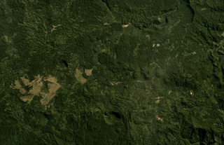
 The Groppo group contains several cones and lava flows, with a younger darker flow near the top of this December 2019 Planet Labs satellite image monthly mosaic (N is at the top; this image is approximately 42 km across). Several phreatomagmatic craters are visible, with complex groups of overlapping vents and at least one possible maar. Several of the scoria cones have craters that experienced flank collapse or rafting during their eruptions, including the northernmost cone.
Satellite image courtesy of Planet Labs Inc., 2020 (https://www.planet.com/).
 A group of scoria cones with recent lava flows of the Tskhouk-Karckar volcanic group are in the center of this October 2019 Planet Labs satellite image monthly mosaic (N is at the top; this image is approximately 16 km across). The longest flow to the south traveled around 9 km from the vent. The lavas have abundant lobate flow edges and pressure ridges, and overlap older cones and flows.
Satellite image courtesy of Planet Labs Inc., 2018 (https://www.planet.com/).
 The Vaiyots-Sar scoria cone has a roughly 500-m-wide summit crater, seen in this August 2020 Planet Labs satellite image monthly mosaic (N is at the top; this image is approximately 15 km across). Lavas with visible flow boundaries and levees are to the NW and S to SW of the cone, with some long, linear flows and some much broader flow fronts with pressure ridges.
Satellite image courtesy of Planet Labs Inc., 2020 (https://www.planet.com/).
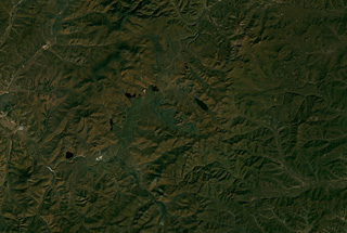
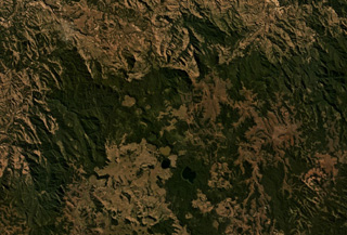
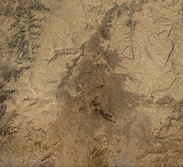
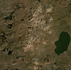 The central part of the 40-km-long (N-S) Samsari Volcanic Center is shown in this September 2019 Planet Labs satellite image monthly mosaic (N is at the top; this image is approximately 30 km across). At least 20 edifices form the complex, and the Samsari edifice and caldera is in the center of the top third of this image. The southernmost cone in this image is Patara Abuli and the closest NW cone is Didi Abuli.
Satellite image courtesy of Planet Labs Inc., 2019 (https://www.planet.com/).
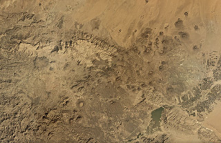
 The Karaca Dag/ Karacadağ shield volcano covers around 10,000 km2 in Turkey, with the more recent N-S plateau of scoria cones and lava flows down the center of this January 2020 Planet Labs satellite image monthly mosaic (N is at the top; this image is approximately 63 km across). A younger group of lava flows erupted from vents on the eastern flank, appearing darker with the vents visible.
Satellite image courtesy of Planet Labs Inc., 2021 (https://www.planet.com/).
 The Göllü Dag volcanic complex in Turkey is shown in this August 2019 Planet Labs satellite image monthly mosaic (N is at the top; this image is approximately 35 km across). The 10-12-km-wide complex formed through the coalescence of at least ten rhyolite domes, with scoria cones, lavas, ignimbrites, and over 25 vents surrounding them. The Aci Gölü maar contains the lake to the upper left, with several scoria cones nearby. The domes are in a rough southeast trend from this maar and have erosion gullies on their flanks.
Satellite image courtesy of Planet Labs Inc., 2020 (https://www.planet.com/).
 This July 2020 Planet Labs satellite image shows some of the southern Huambo volcanic field (in this monthly mosaic N is at the top; image is approximately 26 km across). Near the top of the image, the western cone is Marbas Grande with a 470-m-wide summit crater. East of that are three cones: Marbas north of the ridge then Marbas Chico I and Marbas Chico II south of the ridge. Around the cones are their lava flows.
 Satellite image courtesy of Planet Labs Inc., 2020 (https://www.planet.com/).
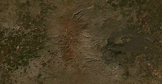
 The Cerro Keyocc cone of the northern Huambo volcanic field is shown below the center of this July 2020 Planet Labs satellite image monthly mosaic (N is at the top; the image is approximately 13 km across). The cone produced a lava flow that traveled down the south of the cone then W, then N. The flow has many lobate breakout flows with pressure ridges along the surfaces.
Satellite image courtesy of Planet Labs Inc., 2020 (https://www.planet.com/).
 The 5-km-wide southern peninsula of Vanua Lava Island, Vanuatu, is seen in this 2018 Planet Labs satellite image monthly mosaic (N is at the top). The Pleistocene Ngere Kwon volcano formed this area, which has since been deeply eroded.
Satellite image courtesy of Planet Labs Inc., 2018 (https://www.planet.com/).
 Craters and cones of Suretamatai in Vanua Lava Island, Vanuatu, are visible across this February 2018 Planet Labs satellite image monthly mosaic (N is at the top; this image is approximately 10 km across). The field covers much of the island, with a NNE-SSW trend of cones (shown here), with the largest edifice towards the northern end having formed multiple craters along a NW-SE trend. Geothermal activity continues.
Satellite image courtesy of Planet Labs Inc., 2019 (https://www.planet.com/).
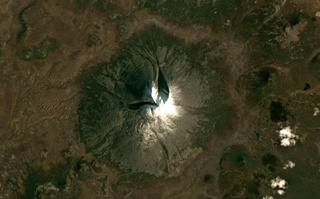
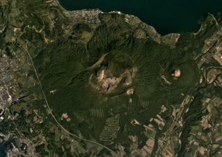 Usu formed along the SW boundary of Toya caldera and is shown in this September 2019 Planet Labs satellite (N is at the top). There is a 2-km-wide crater at the top, and within that crater and on the flanks are a scoria cone, three lava domes, and more than ten cryptodomes. Flank collapse possibly occurred around 8-7 ka, emplacing a debris avalanche deposit to the south.
Satellite image courtesy of Planet Labs Inc., 2019 (https://www.planet.com/).
 Taveuni Island in Fiji is situated along a larger ridge and is approximately 40 km long, shown in this composite image of Sentinel-2 (3 and 6 July) and Landsat 8 (1 July) 2019 images courtesy of Planet Labs (N is at the top). Around 150 vents are aligned along the length of the NW-SE oriented island. The Lake Tagimoucea Basin rift zone is about one-third of the way down and contains lavas offset by faulting.
Satellite image courtesy of Planet Labs Inc., 2019 (https://www.planet.com/).
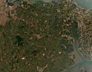 The Leizhou Bandao volcanic field covers much of the southern part of the Leizhou Peninsula. The field contains many scoria cones, with some in the area shown in this December 2020 Planet Labs satellite image monthly mosaic (N is at the top; this image is approximately 23 km across). The field is the northern portion of the Qionglei volcano group.
Satellite image courtesy of Planet Labs Inc., 2020 (https://www.planet.com/).
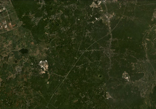 The Hainan Volcanic Field in China contains around 58 identified cones, craters, and maars, some of which are visible in this November 2020 Planet Labs satellite image monthly mosaic (N is at the top; this image is approximately 14 km across). The Leihuling cone with a roughly 300-m-diameter crater is to the SW of the S21 Zhongxian expressway that runs through the center of the image.
Satellite image courtesy of Planet Labs Inc., 2020 (https://www.planet.com/).
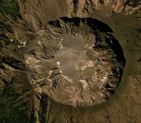 The Tambora caldera formed during the 1815 eruption, after 41 km3 of magma (dense rock equivalent) was expelled, leaving the 6-km-wide and 1-km-deep depression seen in this July 2019 Planet Labs satellite image mosaic (N is to the top). The current area of the caldera is approximately 34.5 km2, with erosion altering the surface and remobilizing material onto the caldera floor.
Satellite image courtesy of Planet Labs Inc., 2019 (https://www.planet.com/).
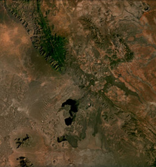 Cones, maars, lava flows, and craters of the Mega Basalt Field located along the Ethiopia-Kenya border are visible across this December 2020 Planet Labs satellite image mosaic (N at the top). It is located near the villages Mega and Megado and covers an area of approximately 1,400 km2. Large lava flows were produced from scoria cones and spatter ramparts, and the largest Maar is El Sod (top right), reaching 2.3 km in diameter and 0.41 km deep.
Satellite image courtesy of Planet Labs Inc., 2020 (https://www.planet.com/).
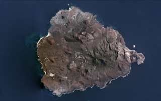 The surface of the nearly 14-km-wide Ascensión Island is composed of mafic and felsic eruptive products including scoria cones, lava flows, and pyroclastic flow deposits, some of which are seen in this July 2020 Planet Labs satellite image monthly mosaic (N is at the top). The larger, eroded edifice in the SE is Green Mountain with White Hill farther E. Numerous scoria cones with summit craters are visible across the island.
Satellite image courtesy of Planet Labs Inc., 2020 (https://www.planet.com/).
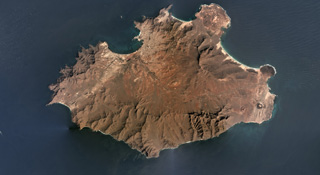 The 25-km-wide Pliocene-Pleistocene São Vicente is shown in this February 2019 Planet Labs satellite image monthly mosaic (N is at the top). The products of the most recent volcanism are at the two NE peninsulas (northern Baia das Gatas and eastern Calhau) and the far-eastern area. The two small cones near the eastern coastline are Vulcãno Viana (right) and Curral de João Paula (left). The linear ridge in the NE area is Monte Verde.
Satellite image courtesy of Planet Labs Inc., 2019 (https://www.planet.com/).
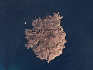 The roughly 9-km-wide Brava Island has numerous domes, coulées, craters, and cones across the island surface, shown in this February 2019 Planet Labs satellite image monthly mosaic (N is at the top). From the SE side towards the center are several domes, including Morro da Pedras and Morro Largo. In the center is the Fundo Grande, Cova Lima Doce, and Cova Joana craters as well as the Munhoto fault zone. Many of the more recent craters formed during phreatomagmatic eruptions.
Satellite image courtesy of Planet Labs Inc., 2019 (https://www.planet.com/).
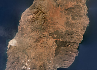 Fuerteventura island comprises the Northern, Central, and Southern Volcanic Complexes, with the Central complex shown in this November 2019 Planet Labs satellite image monthly mosaic (N is at the top; this image is approximately 42 km across). There was a period of significant erosion and quiescence before scoria cones and smaller lava flows were produced during the Quaternary through to recent times, including the darker lava flows and cones near the center of this image.
Satellite image courtesy of Planet Labs Inc., 2019 (https://www.planet.com/).
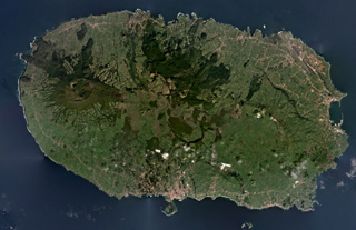 Four main volcanic centers form the 29-km-wide Terceira Island shown in this February 2020 Planet Labs satellite image monthly mosaic (N is at the top). The Santa Barbara edifice with the summit caldera is to the W, with lava domes and coulées both in the caldera and on the flanks, concealing an older caldera on the NE flank. The Pico Alto complex is at the north of the center of the island and to the south of that is the Guilherme Moniz caldera. The NE and SW Cinco Picos caldera rims are exposed on the SE side of the island, with the São Sebastião crater near the SE boundary.
Satellite image courtesy of Planet Labs Inc., 2020 (https://www.planet.com/).
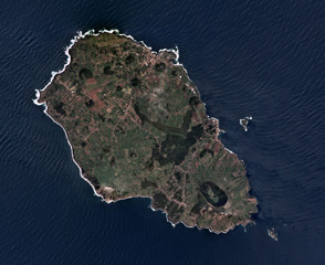 The roughly 7 x 12 km Graciosa island in the Azores archipelago has a 1.2 x 1.9 km caldera at the SE end, shown in this April 2019 Planet Labs satellite image monthly mosaic (N is at the top). The NW area contains scoria cones, many that have undergone flank collapse or rafting during Strombolian eruptions leaving an amphitheater shape, and lava flows. The growth of the island has been disrupted by multiple major flank collapse events through time.
Satellite image courtesy of Planet Labs Inc., 2019 (https://www.planet.com/).
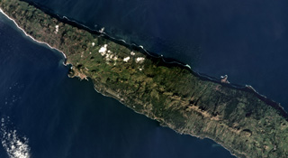 The 54-km-long and up to 6.5-km-wide San Jorge island is shown across this December 2018 Planet Labs satellite image monthly mosaic (N is at the top; this image is approximately 27 km across). The island has three main parts that compose the upper units across the island, with the Rosais Complex to the W, the Manadas Complex in the center, and the Topo complex in the E. The western two-thirds (mostly shown here) has fissure vents across the surface that produced lava flows and spatter ramparts.
Satellite image courtesy of Planet Labs Inc., 2019 (https://www.planet.com/).
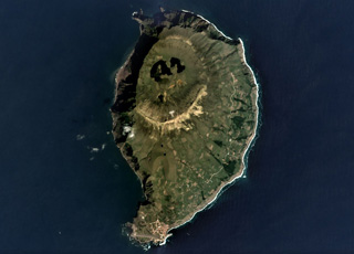 The 4 x 6 km Corvo island of the Azores archipelago is shown in this September 2019 Planet Labs satellite image monthly mosaic (N is at the top). The northern half of the island contains the O Caldeirão caldera and the western coast is composed of cliffs. A scoria cone that opens towards the S is visible below the center of this image, and several other cones and lava flows are across the lower half of the island.
Satellite image courtesy of Planet Labs Inc., 2019 (https://www.planet.com/).
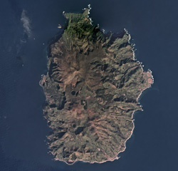 In the Azores archipelago west of the Mid-Atlantic Ridge is the 12 x 17 km Flores Island, shown in this February 2018 Planet Labs satellite image monthly mosaic (N is at the top). Initially a submarine volcano, the island formed through the eruption of different vents, forming cones, craters, maars, and associated eruption products like lava flows.
Satellite image courtesy of Planet Labs Inc., 2019 (https://www.planet.com/).
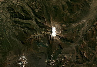 The late-Pleistocene Sierra Nevada in Chile has a N-S oriented glaciated ridge and a 7-km-long E-W alignment of fissure vents in the center of this Planet Labs satellite image monthly mosaic (N is at the top; this image is approximately 40 km across). Steep cliffs on the western side expose the stratigraphy of the summit area.
Satellite image courtesy of Planet Labs Inc., 2019 (https://www.planet.com/).
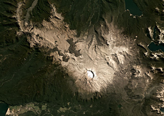 The Puyehue-Cordón Caulle volcanic complex spans 120 km2 across this March 2021 Planet Labs satellite image monthly mosaic (N is at the top) with the 2.4-km-wide Puyehue caldera to the E, the Cordillera Nevada caldera near the center, and the Cordón Caulle fissure system to the W. The darker 2011-2012 Cordón Caulle obsidian lava flows extend up to around 3 km from the vents. Older fissure ridges are visible in the western segment.
Satellite image courtesy of Planet Labs Inc., 2019 (https://www.planet.com/).
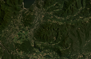 The cones with summit craters at the SW corner of Lago Caburgua (upper left) are the Volcanes de Caburgua. South of the lake are two areas with thicker vegetation, the northern area is the La Barda cones, and the southern is Volcan Huelemolle. The vegetated ridge across the eastern half of the photo contains the Redondo, Pichares, and Relicura cones (E to W).
Satellite image courtesy of Planet Labs Inc., 2021 (https://www.planet.com/).
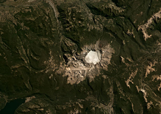 The 4-km-wide Sollipulli caldera contains over 500 m of ice (593 m measured in 2011) and overlaps an older caldera on the left in the center of this Planet Labs satellite image monthly mosaic (N is at the top; this image is approximately 40 km across). Around the caldera rim eruptions have formed lava flows, coulées, and domes, and on the SW rim is the 1-km-wide Alpehué crater. The Alpehué geyser field is on the SW flank near the summit area and recent scoria cones are on the NE flank.
Satellite image courtesy of Planet Labs Inc., 2019 (https://www.planet.com/).
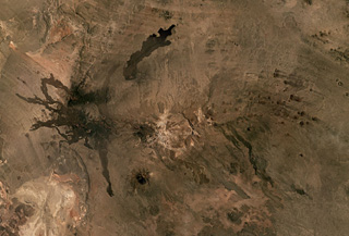 The Cerro Payún Matru volcanic field in Argentina covers 5,200 km2 and contains a roughly 9-10 km diameter caldera in the center of this Planet Labs satellite image monthly mosaic (N is at the top; this image is approximately 81 km across). The caldera is associated with an ignimbrite deposit spanning 2,200 km2, and since its formation 168,000 years ago over 300 vents erupted. There are several larger cones with Cerro Payún reaching the highest elevation SSW of the caldera. The Pampas Negras lavas are to the W, and the Santa Maria lava flow is N of the caldera.
Satellite image courtesy of Planet Labs Inc., 2019 (https://www.planet.com/).
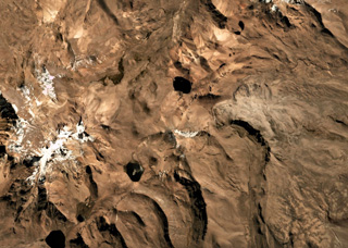 The Pleistocene Patilla Pata complex is in the center of this Planet Labs satellite image monthly mosaic (N is at the top; this image is approximately 15 km across). The edifice is deeply glacially eroded with a remnant peak in the center. Volcán Larancagua is to the SW. As of the time of image acquisition, there is no evidence for Holocene activity.
Satellite image courtesy of Planet Labs Inc., 2019 (https://www.planet.com/).
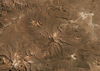 The Pleistocene Nevado Anallajsi volcanic complex in Bolivia is in the center of this Planet Labs satellite image monthly mosaic (N is at the top; this image is approximately 47 km across). The flanks have been deeply eroded and a remnant peak is in the center. At the time of this image acquisition there is no evidence for Holocene activity.
Satellite image courtesy of Planet Labs Inc., 2019 (https://www.planet.com/).
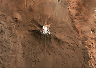 Aracar volcano in Argentina has a 1.5-km-wide summit crater in the center of this May 2019 Planet Labs satellite image monthly mosaic (N is at the top; this image is approximately 22 km across). Lobate lava flows with pressure ridges are exposed along the lower southern flanks, and lava flows have been emplaced around topographic highs on the W, E, and S.
Satellite image courtesy of Planet Labs Inc., 2019 (https://www.planet.com/).
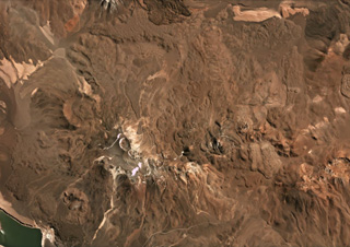 The Falso Azufre volcanic complex, covering 387 km2 at the Chile-Argentina border, was constructed largely by lava flows up to 7 km long and 4 km wide, shown in this April 2019 Planet Labs satellite image monthly mosaic (N is at the top; this image is approximately 22 km across). The crater of the Kunstmann edifice is in the upper left corner, and the eastern domes, coulees, and lava flows are to the far right. The summit region craters are aligned along a NW-SE trend to the W (the Falso Azufre edifice), and along a ENE-WSW trend on the eastern side (the Dos Conos edifice).
Satellite image courtesy of Planet Labs Inc., 2019 (https://www.planet.com/).
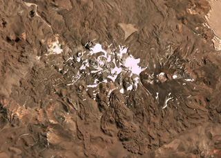 This April 2019 Planet Labs satellite image monthly mosaic (N is at the top; this image is approximately 23 km across) highlights the lava flow morphologies of the Sierra Nevada complex in Chile. The complex covers around 225 km2 and has at least 12 vents with associated lava flows. The 1-km-wide Cumbre del Laudo crater is on the eastern end with an oxidized scoria deposit around the vent.
Satellite image courtesy of Planet Labs Inc., 2019 (https://www.planet.com/).
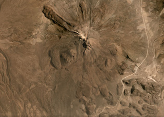 The flanks of Tata Sabaya have largely formed through the extrusion of lava domes and flows, with some lobate flows displaying pressure ridges and levees seen in this September 2019 Planet Labs satellite image monthly mosaic (N is at the top; this image is approximately 12 km across). The NW end of a hummocky roughly 300 km2 debris avalanche deposit is in the lower right corner of this image. The collapse scarp from the flank collapse that produced the deposit and opened toward the S has been subsequently filled by lava domes.
Satellite image courtesy of Planet Labs Inc., 2019 (https://www.planet.com/).
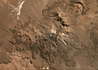 The flanks of Isluga volcano in Chile are formed by numerous lobate lava flows visible in this June 2019 Planet Labs satellite image monthly mosaic (N is at the top; this image is approximately 23 km across). The lavas have lateral levees and pressure ridges especially visible on the southern flanks. The most recent 400-m-diameter summit crater is visible at the western side of the summit area.
Satellite image courtesy of Planet Labs Inc., 2019 (https://www.planet.com/).
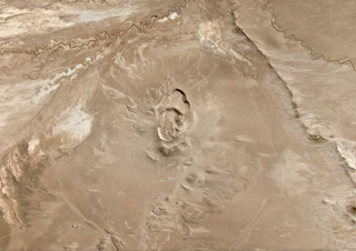 Cerro Volcán Tambo Quemado is located in the Bolivian Altiplano and is in the center of this June 2019 Planet Labs satellite image monthly mosaic (N is at the top; this image is approximately 24 km across). Three overlapping craters form the complex, with a lava dome inside the youngest.
Satellite image courtesy of Planet Labs Inc., 2019 (https://www.planet.com/).
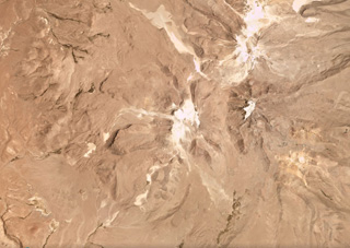 Glaciated Volcán Guallatiri is in the center of this December 2017 Planet Labs satellite image monthly mosaic (N is at the top; this image is approximately 23 km across). Thick lava flows, domes, and coulees form the flanks, a lava dome complex forms the summit, and both the summit and southwest fumarole fields remain active. The Domo Tinto lava dome formed on the SSW flank around 5,000 years ago.
Satellite image courtesy of Planet Labs Inc., 2017 (https://www.planet.com/).
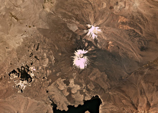 Parinacota is the larger of the two main edifices in this November 2019 Planet Labs satellite image monthly mosaic (N is at the top; this image is approximately 23 km across). With Pomerape to the NE, together they form the Nevados de Payachata group along the Chile-Bolivia border. The group of lakes to the SW formed within a debris avalanche deposit about 8,000 years ago that is more than 22 km long with a volume of 6 km3. The current cone formed over the resulting scarp and older edifice, and has a summit crater around 650 m wide. Lava flows are visible on all flanks, with some flows emplaced around the debris avalanche deposit hummocks.
Satellite image courtesy of Planet Labs Inc., 2019 (https://www.planet.com/).
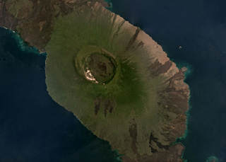 The summit caldera of the Alcedo shield volcano, 7-8.5 km in diameter, is near the center of this March 2019 Planet Labs satellite image monthly mosaic (N is at the top). The caldera contains rhyolite lavas, and both rhyolite tephra and pumice have erupted from three identified vents. Radial basalt lava flows form the flanks like the other five volcanoes that make up Isabela Island. The southern flank of Volcán Darwin is to the north and lava flows from Sierra Negra are to the south.
Satellite image courtesy of Planet Labs Inc., 2019 (https://www.planet.com/).
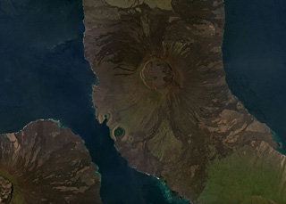 The 5-km-diameter, 200-m-deep summit caldera of the Volcán Darwin is near the center of this March 2019 Planet Labs satellite image monthly mosaic (N is at the top). Lava flows on all flanks have erupted from circumferential and radial fissures around the flanks and into the caldera. The Beagle and Tagus tuff cones are along the SW coastline, with the northern Tagus Cone containing Tagus Cove. Fernandina is SW and the northern flanks of Alcedo are S; Volcán Darwin is out of view to the N.
Satellite image courtesy of Planet Labs Inc., 2019 (https://www.planet.com/).
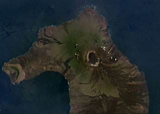 The 700-m-deep summit caldera of the Volcán Wolf shield volcano on Isabela Island, Galapagos Islands, is near the center of this March 2019 Planet Labs satellite image monthly mosaic (N is at the top; this image is approximately 50 km across). Lava flows have erupted from radial and circumferential fissures from the summit to the lower flanks. Volcán Ecuador and its East Rift zone forms the western peninsula, and the northern flank of Volcán Darwin is to the south.
Satellite image courtesy of Planet Labs Inc., 2019 (https://www.planet.com/).
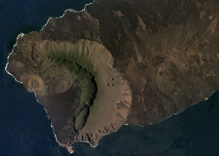 The western side of Volcán Ecuador has formed through caldera collapse and subsequent flank collapse, producing the caldera that opens towards the ocean in this March 2019 Planet Labs satellite image monthly mosaic (N is at the top; this image is approximately 13 km across). Within the caldera is the Cerro Grande tuff cone along the coast, a slump block along the SE caldera wall, and lava flows, as well as smaller vents. The East Rift is to the right in this image, towards Volcán Wolf out of view.
Satellite image courtesy of Planet Labs Inc., 2019 (https://www.planet.com/).
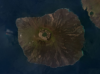 The Fernandina shield volcano in the Galapagos Islands has a roughly 5 x 6 km summit caldera seen in this March 2019 Planet Labs satellite image monthly mosaic (N is at the top). Frequent eruptions often produce circumferential fissures near the caldera as well as fissures on the lower flanks that feed lava flows, many of which are visible in a radial pattern around the flanks. Lava flows and collapse events around the caldera walls modify the caldera floor, which has a lake at the time of this image acquisition.
Satellite image courtesy of Planet Labs Inc., 2019 (https://www.planet.com/).
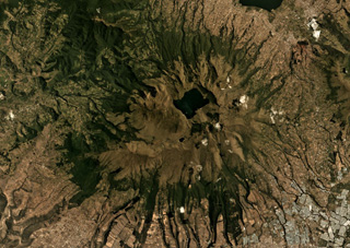 Mojanda volcano has a 3-km-wide caldera that contains the Laguna Grande de Mojanda, shown in this August 2019 Planet Labs satellite image monthly mosaic (N is at the top; this image is approximately 24 km across). The complex contains the older Fuya Fuya to the W, and Mojanda to the E. Fuya Fuya underwent a large flank collapse that produced the horseshoe-shaped scarp on the SW side, opening towards the W. The Cerro el Panecillo dome is on the NW flank.
Satellite image courtesy of Planet Labs Inc., 2019 (https://www.planet.com/).
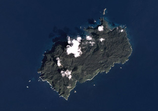 The 22 km2 Isla del Coco (Cocos Islands) is the subaerial portion of the Cocos Ridge, shown in this December 2019 Planet Labs satellite image monthly mosaic (N is at the top). A Pliocene-Pleistocene shield volcano partly forms the roughly 7-km-long (in the NE-SW direction) island. Steep cliffs around the coast expose thick columnar-jointed lava flows, thin lavas, and breccias (possibly debris flows).
Satellite image courtesy of Planet Labs Inc., 2019 (https://www.planet.com/).
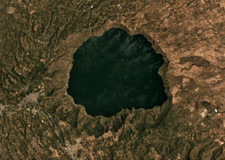 The 6.5-km-diameter Apoyo caldera formed during two Plinian eruptions around 24,000 years ago, seen in this March 2019 Planet Labs satellite image monthly mosaic (N is at the top; this image is approximately 13 km across). The caldera was created within broad lavas that formed the previous edifice.
Satellite image courtesy of Planet Labs Inc., 2019 (https://www.planet.com/).
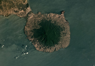 Maderas volcano forms the 12-km-wide SE part of Ometepe island, with Concepción out of view to the NE of this March 2019 Planet Labs satellite image monthly mosaic (N is at the top). The ridge on the SW flank is due to slumping and the ridge across the NE flank is due to normal faulting, creating a graben across the top of the edifice. A summit crater has formed within the graben.
Satellite image courtesy of Planet Labs Inc., 2019 (https://www.planet.com/).
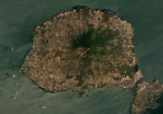 The steep Volcán Concepción forms the center of the northeastern portion of Ometepe Island in Lake Nicaragua, shown in this March 2019 Planet Labs satellite image monthly mosaic (N is at the top; this image is approximately 24 km across). Deformation occurs due to the volcano forming on top of unstable lake sediments of mud and clay. Spatter cones, cinder cones, lava domes, and maars have formed across the flanks. Maderas volcano forms the SE side of the island, out of view here.
Satellite image courtesy of Planet Labs Inc., 2019 (https://www.planet.com/).
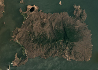 The roughly 7 x 10 km Zapatera island contains more than 30 vents across 150 km2, shown in this March 2019 Planet Labs satellite image monthly mosaic (N is at the top; this image is approximately 12 km across). The island is heavily faulted due to the Ochomogo fault zone, and a 150-m-high scarp is along the center.
Satellite image courtesy of Planet Labs Inc., 2019 (https://www.planet.com/).
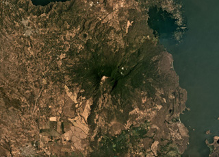 Two major flank-collapse scarps on the NE and SW sides of Mombacho are visible in this March 2019 Planet Labs satellite image monthly mosaic (N is at the top; this image is approximately 25 km across). The islands to the NE are part of the 56.8 km2 Las Isletas debris avalanche deposit; the 49.5 km2 El Crater debris avalanche deposit is to the S. The La Danta debris avalanche deposit is between the two on the SE flank and surrounding area.
Satellite image courtesy of Planet Labs Inc., 2019 (https://www.planet.com/).
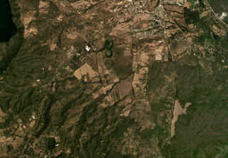 The Granada volcanic complex contains maars and scoria cones, with some shown in this February 2020 Planet Labs satellite image monthly mosaic (N is at the top; this image is approximately 9 km across). Near the center of this image is the N-S trending La Joya maar chain. SW of that are several scoria cones, one with a preserved crater and one with a quarry next to the road.
Satellite image courtesy of Planet Labs Inc., 2020 (https://www.planet.com/).
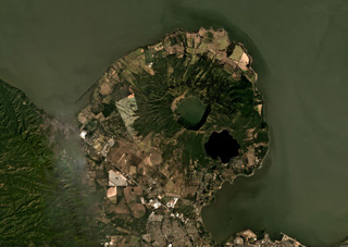 The Apoyeque caldera to the left and the Xiloá Maar to the right are part of the Apoyeque volcanic complex shown in this December 2019 Planet Labs satellite image monthly mosaic (N is at the top; this image is approximately 27 km across). Apoyeque is one of 11 features within the Chiltepe Volcanic Complex at the northern end of the Nejapa Volcanic Field. The ridge to the ENE of the caldera is composed of cones, domes, and lava flows, and Cerro Talpetate is south of the maar.
Satellite image courtesy of Planet Labs Inc., 2019 (https://www.planet.com/).
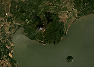 Momotombo rises above the NW shore of Lake Managua and is in the center of this December 2019 Planet Labs satellite image monthly mosaic (N is at the top; this image is approximately 22 km across). Gas emissions emanating from the summit crater are dispersing to the SW. Lava has flowed into Monte Galán caldera on the NW flank towards Cerro Motoso, a cone on the NW caldera rim. The island to the SE is Volcán Momotombito and is part of the Momotombo complex. Lava flows in 2015 were emplaced down the NE flank on top of 1905 flows.
Satellite image courtesy of Planet Labs Inc., 2019 (https://www.planet.com/).
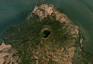 The Cosigüina caldera, 2.5 km wide and more than 500 m deep, is in the center of this December 2019 Planet Labs satellite image monthly mosaic (N is at the top; this image is approximately 25 km across). The ridge SE of the caldera is the Loma San Juan lava flows, and the El Barranco Maar is NNE of the caldera. The arcuate ridge to the W is the Filete Cresta Montosa, interpreted as the remains of an older caldera.
Satellite image courtesy of Planet Labs Inc., 2019 (https://www.planet.com/).
 The eroded Pleistocene Cerro Buena Vista is in the center of this October 2019 Planet Labs satellite image monthly mosaic (N is at the top; this image is approximately 13 km across). It is located in the Jucuarán Range in the SE corner of El Salvador, and on the southern flank In Cerro Madrecacao, also heavily eroded and Pleistocene in age.
Satellite image courtesy of Planet Labs Inc., 2019 (https://www.planet.com/).
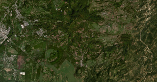 The Lake Yojoa volcanic field in Honduras is located along the northern shore of Lake Yojoa, shown in this October 2019 Planet Labs satellite image monthly mosaic (N is at the top; this image is approximately 12 km across). The field contains scoria and spatter cones and lava flows, with the Cerro el Hoyo in the bottom-center, to the W is the smaller Cerro el Copito cone on the other side of the larger unnamed crater, and Cerro Babilonia in the center of the top of the image.
Satellite image courtesy of Planet Labs Inc., 2019 (https://www.planet.com/).
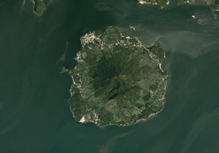 The 5.5-km-wide Isla del Tigre is located in the Gulf of Fonseca in Honduras, shown in this October 2019 Planet Labs satellite image monthly mosaic (N is at the top). There is a crater just below the summit on the southern flank as well as several other flank craters including El Vigía on the NW flank, just NE of the lake near the shore.
Satellite image courtesy of Planet Labs Inc., 2019 (https://www.planet.com/).
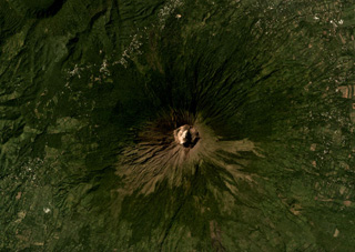 The summit crater of San Miguel, or Chaparrastique, volcano is in the center of this November 2019 Planet Labs satellite image monthly mosaic (N is at the top; this image is approximately 12 km across). Spatter and scoria cones have formed across the flanks during eruptions that emplaced lava flows up to 8 km from the vent. A flank cone that erupted a lava flow during the 1699 eruption is in the SW corner of this image (now vegetated) and the Chinameca caldera is in the NW corner.
Satellite image courtesy of Planet Labs Inc., 2019 (https://www.planet.com/).
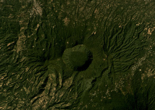 The 2.4-km-wide Laguna Seca el Pacayal is the caldera of Chinameca in the center of this December 2019 Planet Labs satellite image monthly mosaic (N is at the top). The smaller cone on the SW flank is Cerro el Limbo with a summit reaching above the caldera rim.
Satellite image courtesy of Planet Labs Inc., 2019 (https://www.planet.com/).
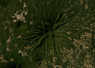 The eroded El Tigre volcano is in the center of this December 2019 Planet Labs satellite image monthly mosaic (N is at the top; this image is approximately 13.5 km across). The eroded cones of Cerro Oromontique and La Manita are below the western and southern flanks, respectively, and the Cerro Alegria crater is in the NW corner of this image.
Satellite image courtesy of Planet Labs Inc., 2019 (https://www.planet.com/).
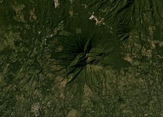 Usulután is the eroded volcano in the center of this November 2019 Planet Labs satellite image monthly mosaic (N is at the top; this image is approximately 12 km across). The eroded flank in the NE corner is El Tigre and the small cone between them is La Manita.
Satellite image courtesy of Planet Labs Inc., 2019 (https://www.planet.com/).
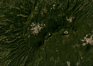 The Tecapa volcanic complex contains the cones and craters through the center of this November 2019 Planet Labs satellite image monthly mosaic (N is at the top; this image is approximately 12 km across). The craters in the NE-SW line from the one in the center in this image are Hoyon (center), Cerro Peylon, and Cerro Las Palmas; the Ausoles de la Laguna de Alegría thermal area is within the crater containing the lake towards the E.
Satellite image courtesy of Planet Labs Inc., 2019 (https://www.planet.com/).
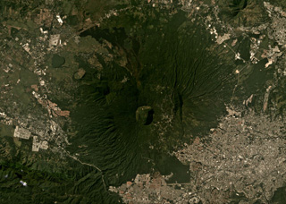 The 1.5-km-wide Boquerón crater of San Salvador is in the center of this November 2019 Planet Labs satellite image monthly mosaic (N is at the top), with the small Boqueroncito scoria cone in the center. A 6 x 4.5 km caldera formed around 40-30 ka and the current El Boquerón edifice was built within it. Recent activity was concentrated in the northern sector with lava flows emplaced on the N flank and within the crater.
Satellite image courtesy of Planet Labs Inc., 2019 (https://www.planet.com/).
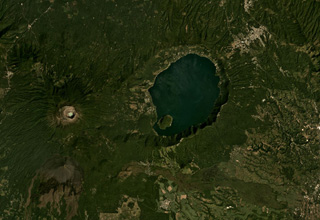 The 7 x 10 km lake-filled Coatepeque Caldera formed 72 ka and is shown in this November 2019 Planet Labs satellite image monthly mosaic (N is at the top; this image is approximately 25 km across). The western caldera rim formed on the Santa Maria eastern flank, and several lava domes formed in the SW area with Cerro Grande forming the island within the lake. Santa Ana with its blue-green crater lake and Izalco with the unvegetated slopes are W and SW, respectively.
Satellite image courtesy of Planet Labs Inc., 2019 (https://www.planet.com/).
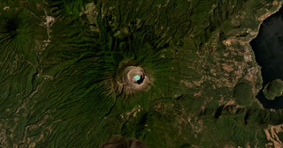 Santa Ana (or Ilamatepec) has several nested summit craters, with the active crater containing the blue lake shown in this February 2021 Planet Labs satellite image monthly mosaic (N is at the top; this image is approximately 16 km across). Several small cones have formed along the SE flank, down to the San Marcelino scoria cone that emplaced the 13-km-long lava flow eastwards in 1722. The Coatepeque Caldera is to the E and the Apaneca Range is to the W.
Satellite image courtesy of Planet Labs Inc., 2021 (https://www.planet.com/).
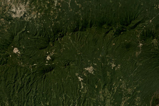 The E-W trending Apaneca Range is across the middle of this November 2019 Planet Labs satellite image monthly mosaic (N is at the top; this image is approximately 25 km across). The range includes the roughly E-W ridge along the upper half of this image, and the two cones below it – the linear Cerro de Apaneca and Cuyotepe just E of it. The crater on the western end of the ridge is Laguna las Ninfas, and the small lake NE is Cerro Laguna Verde. West of those is the Concepción de Ataco caldera.
Satellite image courtesy of Planet Labs Inc., 2019 (https://www.planet.com/).
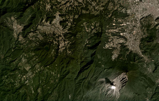 The large scarp of Siete Orejas is down the center of this November 2020 Planet Labs satellite image monthly mosaic (N is at the top; this image is approximately 21 km across). Seven peaks surround the scarp, which likely formed during flank collapse towards the south. The city of Quetzaltenango is NE and Santa María volcano is SE, with a gas plume rising from the Caliente Dome. The Volcan Chicabal is on the SW flank, containing Chicabal Lake.
Satellite image courtesy of Planet Labs Inc., 2020 (https://www.planet.com/).
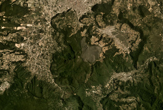 Cerro Quemado is a complex of lava domes and flows, including the unvegetated 1818 deposit in the center of this August 2019 Planet Labs satellite image monthly mosaic (N is at the top; this image is approximately 12 km across). It is part of the Almolonga volcanic group that includes the caldera of Volcán de Almolonga to the E and a series of domes to the N. The city of Quetzaltenango is visible to the N.
Satellite image courtesy of Planet Labs Inc., 2019 (https://www.planet.com/).
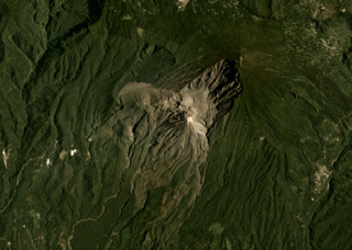 Santa Maria is the large edifice with the broad 1902 crater in the center of this August 2019 Planet Labs satellite image monthly mosaic (N is at the top; this image is approximately 12 km across). The Santiaguito dome complex in comprised of Caliente, the large lava dome in the center of the image, then La Mitad, El Monje, and El Brujo domes from E to W.
Satellite image courtesy of Planet Labs Inc., 2019 (https://www.planet.com/).
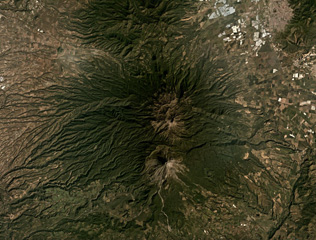 The Colima volcanic complex has two main edifices, the northern Nevado de Colima and the active Volcán de Colima to the south, both in the center of this December 2019 Planet Labs satellite image monthly mosaic (N is at the top; this image is approximately 44 km across). The active cone formed within a 5-km-wide flank collapse scarp, that produced a debris avalanche to the south, one of at least nine collapse events during the past 45,000 years.
Satellite image courtesy of Planet Labs Inc., 2019 (https://www.planet.com/).
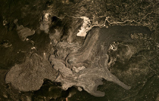 The Medicine Lake volcanic center covers around 2,200 km2, with recent lava flows shown in this August 2019 Planet Labs satellite image monthly mosaic (N is at the top; this image is approximately 10 km across). These lava flows at Big Glass Mountain erupted along the eastern caldera rim and ten lava domes formed in a NW trend, with one lava dome to the south. The western lava flow in this view flowed into the caldera and the eastern flows traveled down the flank.
Satellite image courtesy of Planet Labs Inc., 2019 (https://www.planet.com/).
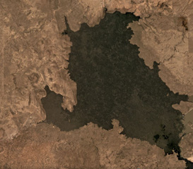 Lava flows covering 68 km2 of the Jordan Craters volcanic field in Oregon, USA, are seen in this September 2019 Planet Labs satellite image monthly mosaic (N is at the top; this image is approximately 15 km across). The Coffeepot Crater in the NW corner is the largest vent and once contained a lava pond.
Satellite image courtesy of Planet Labs Inc., 2019 (https://www.planet.com/).
 The 70 km2 Diamond Craters volcanic field in Oregon, USA, is shown in this October 2019 Planet Labs satellite image monthly mosaic (N is at the top; this image is approximately 15 km across). The area was uplifted to produce graben structures cross-cutting the lavas in NW-SE direction. Numerous smaller vents including spatter and phreatomagmatic craters, and cones occur along the margins of the uplifted area aligned with the structural trend.
Satellite image courtesy of Planet Labs Inc., 2019 (https://www.planet.com/).
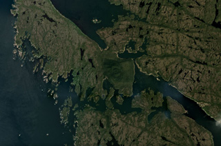 The Milbanke Sound Group contains several cones, with the best preserved Kitasu Hill scoria cone on Swindle Island in the center of this July 2018 Planet Labs satellite image monthly mosaic (N is at the top; this image is approximately 15 km across). Nearby Lake Island and Lady Douglas Island also contain cones and lava flows.
Satellite image courtesy of Planet Labs Inc., 2018 (https://www.planet.com/).
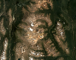 The Spectrum Range is located south of Mount Edziza within the Mount Edziza-Spectrum Range volcanic complex, shown in this July 2018 Planet Labs satellite image monthly mosaic (N is at the top; this image is approximately 48 km across). The edifice is deeply eroded and largely consists of rhyolite domes. The Mess Lake Lava Field is the darker brown area NW of the lighter-colored domes.
Satellite image courtesy of Planet Labs Inc., 2018 (https://www.planet.com/).
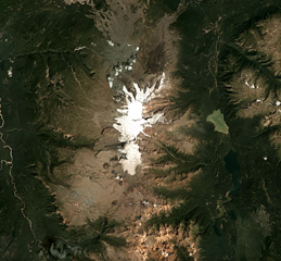 Mount Edziza is an approximately 30-km-long volcanic range that forms the northernmost edifice of the Mount Edziza volcanic complex, and is shown in this July 2018 Planet Labs satellite image monthly mosaic (N is at the top; this image is approximately 42 km across). Many eruptions occurred within ice and water, such as the Tennena cone on the western flank about two-thirds down the ice cap in this view, forming pillow lavas and hydrovolcanic clastic deposits.
Satellite image courtesy of Planet Labs Inc., 2018 (https://www.planet.com/).
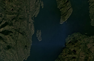 Scoria cones and columnar-jointed lava flows of the Behm Canal-Rudyerd Bay volcanic field occur on either side of Behm Canal (down the center of this image), shown in this October 2020 Planet Labs satellite image monthly mosaic (N is at the top; this image is approximately 20 km across). The majority of outcrops have been found on Revillagigedo Island (left), and additional features are on Rudyerd Island (near the center).
Satellite image courtesy of Planet Labs Inc., 2020 (https://www.planet.com/).
 The 108-km-wide Nunivak Island volcanic field in the Bering Sea off Alaska is shown in this October 2019 Planet Labs satellite image monthly mosaic (N is at the top; this image is approximately 96 km across). There are around 60 scoria cones and four maars across the island, with lava flows 3-15 m thick and less than 3.5 km long forming much of the Island surface.
Satellite image courtesy of Planet Labs Inc., 2019 (https://www.planet.com/).
 St. Paul island, one of the Pribilof Islands in the Bering Sea, is composed of overlapping scoria cones, spatter cones, and lava flows, shown in this October 2017 Planet Labs satellite image monthly mosaic (N is at the top; this image is approximately 23 km across). Cones include the westernmost Rush hill, Black Bluffs scoria cone on the southern peninsula, the Bogoslof Hill complex in the center, and North Hill along the northern coastline.
Satellite image courtesy of Planet Labs Inc., 2017 (https://www.planet.com/).
 The Tana volcanic complex is the eastern part of Chuginadak Island, shown in this 23 August 2020 Sentinel-2 satellite image (N is at the top; this image is approximately 17 km across). The summit area is a nearly E-W alignment of volcanic centers, with the lake-filled summit crater on the western end. From the western rim of that crater is the E-W Tana fissure, and from there down into the Chuginadak isthmus are additional younger fissures and scoria cones. Cleveland volcano forms the western part of the island.
Satellite image courtesy of Planet Labs Inc., 2020 (https://www.planet.com/).
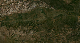 Beyond the NW tip of Lake Baikal is the Tunkin (or Tunka) Depression volcanic field, shown in this September 2019 Planet Labs satellite image monthly mosaic (N is at the top; this image is approximately 170 km across). The field is the surface manifestation of a rift zone and contains five main groups of scoria cones and lava flows that were produced during the late-Pleistocene to Holocene.
Satellite image courtesy of Planet Labs Inc., 2019 (https://www.planet.com/).
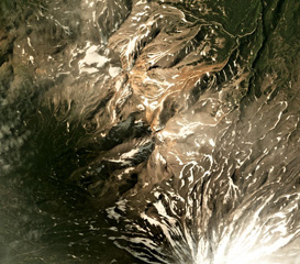 Aak volcano is in the center to the upper left of this August 2019 Planet Labs satellite image monthly mosaic (N is at the top; this image is approximately 13 km across). The edifice has two main eroded centers, Arik peak in the center and Pinachevsky in the NW section. The northern flanks of Koryaksky are to the lower right.
Satellite image courtesy of Planet Labs Inc., 2019 (https://www.planet.com/).
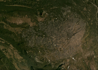 The summit of the broad Plosky volcano is east of the center of this September 2018 Planet Labs satellite image monthly mosaic (N is at the top; this image is approximately 15 km across), west of the northern Sredinny Range. Three scoria cones are preserved on the flanks, one on the NW flank produced a 1.5-km-long lava flow.
Satellite image courtesy of Planet Labs Inc., 2019 (https://www.planet.com/).
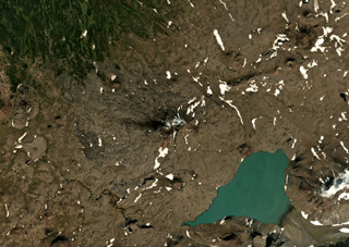 Titila volcano in Kamchatka is in the center of this September 2018 Planet Labs satellite image monthly mosaic (N is at the top; this image is approximately 16 km across). The summit has two craters and scoria cones have formed across the flanks, many of which have emplaced lava flows.
Satellite image courtesy of Planet Labs Inc., 2018 (https://www.planet.com/).
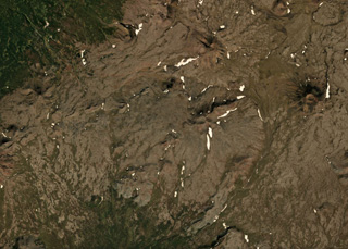 Activity at Tuzovsky shield volcano has formed several scoria cones visible in this September 2018 Planet Labs satellite image monthly mosaic (N is at the top; this image is approximately 13 km across). The cone to the right with a ~300-m-wide summit crater is Sredny, and 4 km NW is Tvitunup. The Tuzovsky cone is near the center of the image.
Satellite image courtesy of Planet Labs Inc., 2018 (https://www.planet.com/).
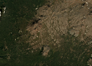 The Leutongey shield volcano has produced scoria cones and lava flows, with several of these near the center of this September 2018 Planet Labs satellite image monthly mosaic (N is at the top; this image is approximately 14 km across). The two larger cones are near the center of this image, the relatively western cone with a 500-m-diameter crater and the southern Medvevezhy cone.
Satellite image courtesy of Planet Labs Inc., 2018 (https://www.planet.com/).
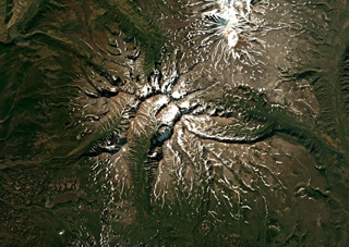 The extensively eroded Schmidt volcano is shown in this September 2019 Planet Labs satellite image monthly mosaic (N is at the top; this image is approximately 33 km across). This was one of the largest early Pleistocene volcanoes in Kamchatka, and after a period of inactivity produced scoria cones on the E and NE flanks during the Holocene.
Satellite image courtesy of Planet Labs Inc., 2018 (https://www.planet.com/).
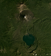 Karymsky is in the north and the Akademia Nauk caldera containing Karymsky Lake is in the south of this August 2019 Planet Labs satellite image monthly mosaic (N is at the top; this image is approximately 19 km across). Along the northern rim of the lake is the 1996 eruption vent, and south of the lake is the Polovinka caldera rim. The current Karymsky cone has formed within the older Karymsky caldera, and adjacent to the northern rim is the Dvor caldera.
Satellite image courtesy of Planet Labs Inc., 2019 (https://www.planet.com/).
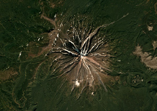 The current Opala cone formed along the northern rim of the 13 x 19 km Pleistocene caldera that formed during the largest eruption in Kamchatka in 50,000 years, shown in this September 2018 Planet Labs satellite image monthly mosaic (N is at the top; this image is approximately 15 km across). The circular feature on the SE flank is the ~1.3 x 2 km Baranii Amphitheater crater, which produced a large eruption in 1400 cal BP and was then filled with an obsidian dome.
Satellite image courtesy of Planet Labs Inc., 2018 (https://www.planet.com/).
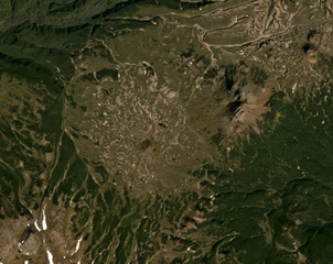 The Visokiy peak is just NE of the center of this September 2019 Planet Labs satellite image monthly mosaic (N is at the top; this image is approximately 15 km across). The smaller cone to the SW (near the center) is Golyi. The volcano is located between Mutnovsky to the NE and Asacha to the SW.
Satellite image courtesy of Planet Labs Inc., 2019 (https://www.planet.com/).
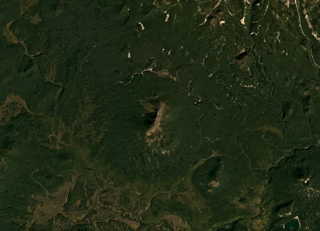 The approximately 2-km-long ridge in the center of this image is Golaya. This September 2018 Planet Labs satellite image monthly mosaic (N is at the top) also shows the southern flank of Asacha volcano N of Golaya, located in southern Kamchatka.
Satellite image courtesy of Planet Labs Inc., 2018 (https://www.planet.com/).
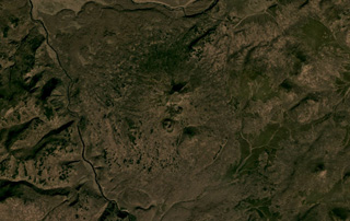 Otdelniy is a small low-relief cone in southern Kamchatka, shown in the center of this October 2020 Planet Labs satellite image monthly mosaic (N is at the top; this image is approximately 14 km across). The central area has several small scoria cones with summit craters, with one cone on the southern flank having nested craters.
Satellite image courtesy of Planet Labs Inc., 2020 (https://www.planet.com/).
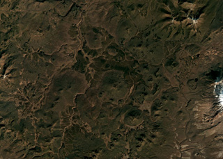 Cones of the Olkoviy Volcanic Group are shown in this October 2018 Planet Labs satellite image monthly mosaic (N is at the top; this image is approximately 30 km across). The group consists of cones and lava flows, with Olkoviy cone in the center of the image and the cone immediately SE is Plosky. The western flank of Khodutka is to the E and the eroded Krugliy cone is in the NE corner.
Satellite image courtesy of Planet Labs Inc., 2018 (https://www.planet.com/).
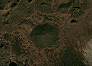 Ozerny is the vegetated low-relief cone in the center of this October 2018 Planet Labs satellite image monthly mosaic (N is at the top; this image is approximately 15 km across). The summit is a scoria cone without a preserved crater, and lava flows reach 1 km N and 1.5 km W.
Satellite image courtesy of Planet Labs Inc., 2018 (https://www.planet.com/).
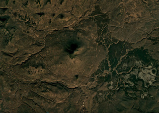 Belenkaya is the small cone in the center of this October 2018 Planet Labs satellite image monthly mosaic (N is at the top; this image is approximately 16 km across). Exposures show that it formed through the emplacement of thin overlapping lava flows.
Satellite image courtesy of Planet Labs Inc., 2018 (https://www.planet.com/).
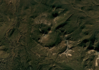 Kell volcano formed within three nested 2-5-km-wide Pleistocene calderas shown in this October 2018 Planet Labs satellite image monthly mosaic (N is at the top; this image is approximately 15 km across). The edifice is composed of several lava domes and cones.
Satellite image courtesy of Planet Labs Inc., 2018 (https://www.planet.com/).
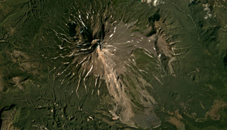 Zheltovsky is in the center of this September 2019 Planet Labs satellite image monthly mosaic (N is at the top; this image is approximately 19 km across). The cone formed within a 4 x 5 km caldera and has a 1.6-km-wide summit crater that has been filled by lava domes. A 2012 landslide is visible on the SE flank, likely a result of altered rock and not related to volcanic activity.
Satellite image courtesy of Planet Labs Inc., 2019 (https://www.planet.com/).
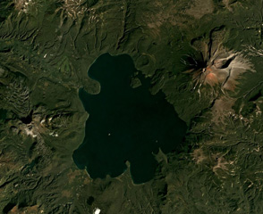 The Kurile Lake caldera, with Iliinsky volcano to the NE of the lake and Diky Greben to the W, is shown in this September 2019 Planet Labs satellite image monthly mosaic (N is at the top; this image is approximately 22 km across). The caldera formed during two large eruptions, with the more recent 7,600 14C yr BP eruption being one of the largest Holocene eruptions around the world. Surrounding the lake are the resulting ignimbrite deposits with some outcrops reaching 150 m thick.
Satellite image courtesy of Planet Labs Inc., 2019 (https://www.planet.com/).
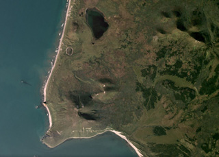 Mashkovtsev is the southernmost Holocene volcano in Kamchatka and forms the small peninsula shown in this September 2019 Planet Labs satellite image monthly mosaic (N is at the top; this image is approximately 5 km across). The small edifice has a post-glacial summit cone and two scoria cones; lava flows are on the N flank.
Satellite image courtesy of Planet Labs Inc., 2019 (https://www.planet.com/).
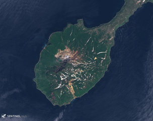 Kuntomintar comprises the southern part of Shiashkotan Island, shown in this June 2020 Planet Labs satellite image monthly mosaic (N is at the top; this image is approximately 8.5 km across). Several Holocene craters are preserved along the summit and geothermal activity occurs within the active crater inside the large scarp that opens to the NW.
Satellite image courtesy of Planet Labs Inc., 2019 (https://www.planet.com/).
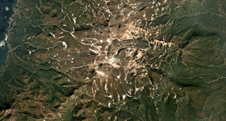 The Vernadskii Ridge in northern Paramushir Island is in the center of this September 2017 Planet Labs satellite image monthly mosaic (N is at the top; this image is approximately 22 km across). The ridge has three main volcano groups including the Vernadskii volcano group in the southern end, and the Bogdanovich volcano group 4-5 km north of that. A 3.5-km-long lava flow with levees and compression ridges was emplaced to the N then turned towards the E.
Satellite image courtesy of Planet Labs Inc., 2017 (https://www.planet.com/).
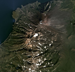 Chikurachki is the northern-most edifice of the Chikurachki-Tatarinov-Lomonosov volcanic chain on the Kurile’s Paramushir Island, shown in this September 2020 Planet Labs satellite image monthly mosaic (N is at the top; this image is approximately 18 km across). The summit has a roughly 450-m-diameter summit crater that is emitting a weak plume dispersing to the E in this image. Tatarinov is the group of craters south of the oxidized Chikurachki cone, and the Lomonsov Group is near the center of the bottom of this image.
Satellite image courtesy of Planet Labs Inc., 2020 (https://www.planet.com/).
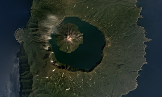 The 7-km-wide Tao-Rusyr Caldera at the southern end of Onekotan Island is shown in this September 2017 Planet Labs satellite image monthly mosaic (N is at the top). The caldera formed at the summit of the broader 16-17 km diameter edifice during an eruption 7,500 years ago, and emplaced a large non-welded ignimbrite deposit. The Krenitsyn Peak cone formed in the NW side of the caldera.
Satellite image courtesy of Planet Labs Inc., 2017 (https://www.planet.com/).
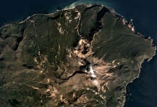 Sinarka is the northernmost of two volcanoes forming Shiashkotan Island, shown in this September 2017 Planet Labs satellite image monthly mosaic (N is at the top; this image is approximately 8 km across). A large part of the NW flank has been removed by landslides and/or explosions, and a wide lava flow has been emplaced within the scarp. A lava dome has filled the summit crater, and another dome has formed 1.5 km SW. The current edifice has filled a previous caldera.
Satellite image courtesy of Planet Labs Inc., 2017 (https://www.planet.com/).
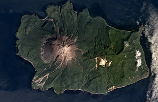 The 5.5 x 8 km Ekarma Island of the Kurile Islands is shown in this August 2017 Planet Labs satellite image monthly mosaic (N is at the top). The volcano forms the western side of the island, with flanks composed of lava flows out to 3 km in all directions and pyroclastic deposits between them. The summit crater has been filled with a lava dome that forms the summit of the cone.
Satellite image courtesy of Planet Labs Inc., 2017 (https://www.planet.com/).
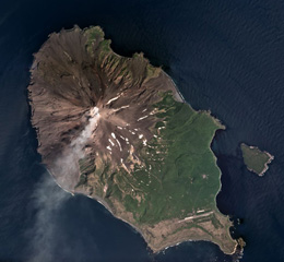 A gas plume is dispersed to the SW of Sarychev Peak in this July 2018 Planet Labs satellite image monthly mosaic (N is at the top; this image is approximately 12 km across). It forms the NW part of the 12 x 6 km Matua Island in the Kurile islands and is one of the most active volcanoes in the area. Lava flows and pyroclastic flow deposits have been emplaced across the flanks, with some pyroclastic flows having reached the sea during explosive eruptions. To the SW of the current edifice is the rim of an older caldera.
Satellite image courtesy of Planet Labs Inc., 2018 (https://www.planet.com/).
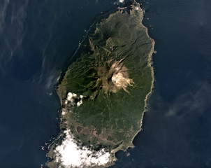 The roughly 6.5 x 15 km Rasshua island has a volcanic edifice largely filling a caldera in the center, shown in this September 2019 Planet Labs satellite image monthly mosaic (N is at the top). The edifice comprises three main cones and the southern rim is visible south of the two lakes.
Satellite image courtesy of Planet Labs Inc., 2019 (https://www.planet.com/).
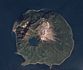 The roughly 10-km-wide Ketoi island is shown in this September 2018 Planet Labs satellite image monthly mosaic (N is at the top). Ketoi is the older edifice and caldera, and Pallas Peak is the cone with a summit crater that has formed within it, NE of Ketoi Lake. Fumaroles are active on the NE flank of the cone.
Satellite image courtesy of Planet Labs Inc., 2018 (https://www.planet.com/).
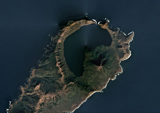 The 7.5-km-wide Pleistocene Uratman caldera containing Brouton Bay and the cone along the SE rim are shown in this October 2018 Planet Labs satellite image monthly mosaic (N is at the top). A lava dome is within the bay and the caldera walls reach up to 450 m in height. Two scoria cones are on the N flank and a lava dome formed on the NW flank.
Satellite image courtesy of Planet Labs Inc., 2018 (https://www.planet.com/).
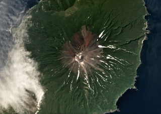 Prevo Peak contains a 450 x 600 m wide summit crater and is located in central Simushir island, shown in this July 2019 Planet Labs satellite image monthly mosaic (N is at the top; this image is approximately 9 km across). Lava flows have been emplaced down the conical flanks and out to both coastlines.
Satellite image courtesy of Planet Labs Inc., 2019 (https://www.planet.com/).
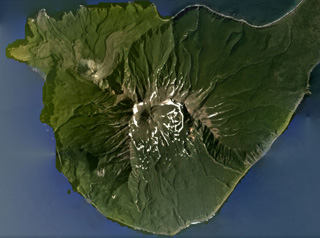 Milna is the southernmost volcano on Simushir island, shown in this August 2020 Planet Labs satellite image monthly mosaic (N is at the top; this image is approximately 13 km across). There is a large scarp across the SE side of the island, opening towards the sea. Within the scarp is a lava dome that grew higher than the scarp walls, and on the NW flank is the Goriaschaia Sopka lava dome with lobate lava flows extending the coastline.
Satellite image courtesy of Planet Labs Inc., 2020 (https://www.planet.com/).
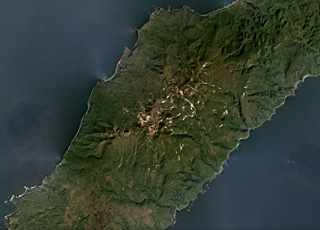 The Ivao Group within the Krishtofovich Ridge has undergone extensive erosion and the remains are mostly lava flows; it is in SW Urup island and contains three remaining cones. The group is in the center of this September 2019 Planet Labs satellite image monthly mosaic (N is at the top; this image is approximately 40 km across).
Satellite image courtesy of Planet Labs Inc., 2019 (https://www.planet.com/).
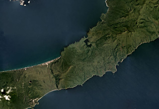 Rucharu (also known as the Golets-Tornyi Group) is in the roughly N-S ridge across the isthmus (narrow part) of Iturup Island, shown in this September 2019 Planet Labs satellite image monthly mosaic (N is at the top; this image is approximately 26 km across). Parusnaya Mountain is at the end of the curved lineament extending from the center of the ridge to the NE.
Satellite image courtesy of Planet Labs Inc., 2019 (https://www.planet.com/).
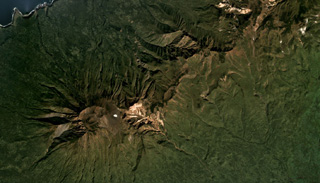 Hitokappu Volcano Group (also called Bogatyr Ridge) is seen diagonally across this September 2019 Planet Labs satellite image monthly mosaic (N is at the top; this image is approximately 13 km across). Stokap is the edifice on the SW end of the ridge and has 8-10 identified domes, cones, and craters at the summit area.
Satellite image courtesy of Planet Labs Inc., 2019 (https://www.planet.com/).
 The 14 x 12 km Shikotsu caldera is shown in this September 2019 Planet Labs satellite image monthly mosaic (N is at the top; this image is approximately 28 km across). Tarumae is the cone on the SE rim of the caldera with a roughly 1.5-km-wide crater containing a lava dome. Between Tarumae and the caldera lake is the eroded Fuppushi cone. On the opposite (NW) side of the caldera is the Eniwa cone.
Satellite image courtesy of Planet Labs Inc., 2019 (https://www.planet.com/).
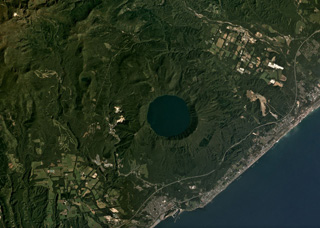 The 3-km-wide Kuttara caldera formed 40,000 years ago and contains Lake Kuttara, shown in this September 2019 Planet Labs satellite image monthly mosaic (N is at the top). The complex also contains cones, domes, and craters, and has ongoing geothermal activity. The Noboribetsu geothermal field and the Hiyoriyama Cryptodome are on the W flank, approximately 1.3 km from the lake edge in this view.
Satellite image courtesy of Planet Labs Inc., 2019 (https://www.planet.com/).
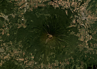 Yoteizan has a 700-800 m wide summit crater and smaller adjoining craters along its NW rim, shown in the center of this September 2019 Planet Labs satellite image monthly mosaic (N is at the top). Erosion has formed radial gullies down the flanks and the roughly 500-m-wide Hangetsu-ko crater is on the NW flank.
Satellite image courtesy of Planet Labs Inc., 2019 (https://www.planet.com/).
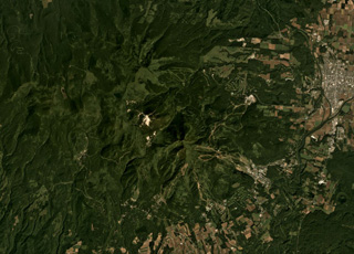 The Niseko complex is shown in this September 2019 Planet Labs satellite image monthly mosaic (N is at the top; this image is approximately 18 km across). The complex contains multiple cones and lava domes including Chisenupuri, Iwaonupuri (the light area near the image center), Niseko-Annupuri, and Nitonupuri domes. The small crater near the lower right corner is Hangetsu-ko of Yoteizan volcano.
Satellite image courtesy of Planet Labs Inc., 2019 (https://www.planet.com/).
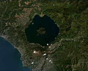 Usu is along the SW boundary of the larger Toya caldera and is shown here in this September 2019 Planet Labs satellite image monthly mosaic (N is at the top). The Usu edifice summit contains the collapse scarp in the center of the image, which is 1.5-2 km across and contains both domes and cryptodomes. Additional cryptodomes surround the scarp from the NW around to the SE.
Satellite image courtesy of Planet Labs Inc., 2020 (https://www.planet.com/).
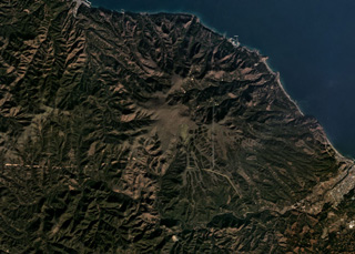 The Pleistocene Mutsu-Hiuchidake is the northernmost volcano on Honshu, seen here in this November 2019 Planet Labs satellite image monthly mosaic (N is at the top; this image is approximately 14 km across). Geothermal activity continues in the area.
Satellite image courtesy of Planet Labs Inc., 2019 (https://www.planet.com/).
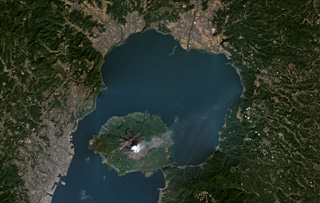 Sakurajima within Aira caldera is producing a gas plume to the NE in this November 2020 Planet Labs satellite image monthly mosaic (N is at the top; this image is approximately 43 km across). The 17 x 23 km caldera formed about 29,000 years ago during the eruption of around 98 km3 of pumice and 300 km3 of pyroclastic flows. In recent times the main epicenter for activity is Sakurajima that has since formed in Kagoshima Bay and is seen here with a weak gas plume dispersing NE to E.
Satellite image courtesy of Planet Labs Inc., 2020 (https://www.planet.com/).
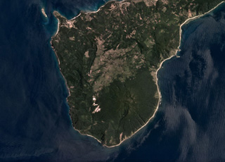 Camiguin de Babuyanes is located in southern Camiguin Island in the Babuyan archipelago, north of Luzon Island, and is seen in this June 2019 Planet Labs satellite image monthly mosaic (N is at the top). At this point the island is around 5 km wide. The volcano includes the Camiguin edifice, along with Minabul and Caanoan cones to the N and E, respectively.
Satellite image courtesy of Planet Labs Inc., 2019 (https://www.planet.com/).
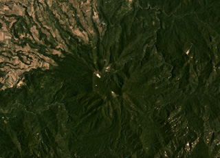 The roughly 2-km-wide Cagua summit crater is in the center of this April 2019 Planet Labs satellite image monthly mosaic (N is at the top), at the NE peninsula of Luzon island. The flanks contain thick pyroclastic flow deposits that were emplaced 600,000 to 300,000 years ago and are now eroded.
Satellite image courtesy of Planet Labs Inc., 2019 (https://www.planet.com/).
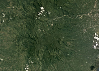 Cuernos de Negros is a large volcano composed of multiple edifices including Mount Talines, Mount Guinsayawan, and Guintabon Dome, seen in this June 2017 Planet Labs satellite image monthly mosaic (N is at the top; this image is approximately 24 km across). The Magaso summit crater contains active fumaroles and the Palinpinon geothermal field is on a N flank.
Satellite image courtesy of Planet Labs Inc., 2017 (https://www.planet.com/).
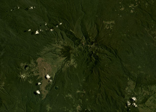 Ragang volcano in central Mindanao is in the center of this August 2019 Planet Labs satellite image monthly mosaic (N is at the top; this image is approximately 24 km across). Latukan is to the SW, past lava flows with visible levees and pressure ridges that appear to have erupted from flank vents.
Satellite image courtesy of Planet Labs Inc., 2019 (https://www.planet.com/).
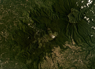 The Apo volcanic complex is composed of four edifices and several smaller cones, with the Apo dome being the youngest feature. The edifice is in the center of this August 2019 Planet Labs satellite image, which is approximately 24 km across. Geothermal activity continues in the area with a power plant within 3 km of the Apo dome.
Satellite image courtesy of Planet Labs Inc., 2019 (https://www.planet.com/).
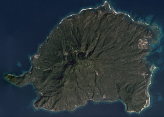 The eroded Balut edifice is in the center of this December 2019 Planet Labs satellite image monthly mosaic (N is at the top). Hot springs and thermally altered ground are located on the W and SW flanks. The island is approximately 11 km in the E-W direction.
Satellite image courtesy of Planet Labs Inc., 2019 (https://www.planet.com/).
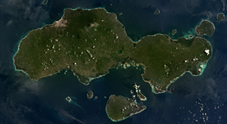 The 61-km-long Jolo island contains numerous cones and craters, some of which are visible in this August 2019 Planet Labs satellite image monthly mosaic (N is at the top). The 1.3-km-diameter lake-filled crater visible in the center of the island is Mount Panamao.
Satellite image courtesy of Planet Labs Inc., 2019 (https://www.planet.com/).
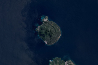 Hiri is a 3-km-wide volcanic island north of Ternate Island (in the bottom of this image) off the coast of Halmahera island and is in the center of this June 2019 Planet Labs satellite image monthly mosaic (N is at the top). The highest part of the island has formed within a broad circular scarp that opens towards the W.
Satellite image courtesy of Planet Labs Inc., 2019 (https://www.planet.com/).
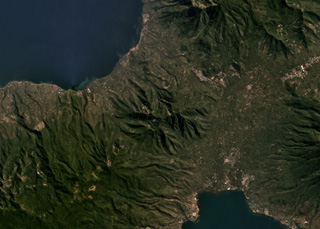 The extensively eroded Ilikedeka volcano is in the center of this July 2019 Planet Labs satellite image monthly mosaic (N is at the top; this image is approximately 11 km across). The Riang Kotang geothermal area is on the lower N flank, and there is other geothermal activity that occurs in the area.
Satellite image courtesy of Planet Labs Inc., 2019 (https://www.planet.com/).
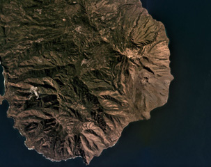 Iliwerung forms a peninsula in southern Lembata island, seen here in this July 2019 Planet Labs satellite image monthly mosaic (N is at the top; this image is approximately 11 km across). The 330 x 400 m recent crater is near the eastern coastline in this view and submarine eruptions have produced ephemeral islands off the SE flank.
Satellite image courtesy of Planet Labs Inc., 2019 (https://www.planet.com/).
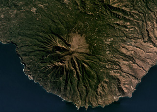 Ililabalekan forms a peninsula in SW Lembata island, seen here in this July 2019 Planet Labs satellite image monthly mosaic (N is at the top; this image is approximately 11 km across). The flanks are extensively eroded and geothermal activity occurs at the summit.
Satellite image courtesy of Planet Labs Inc., 2019 (https://www.planet.com/).
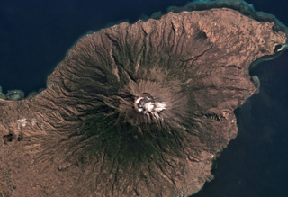 The approximately 800-m-diameter Lewotolo summit crater is in the center of this July 2019 Planet Labs satellite image monthly mosaic (N is at the top). A smaller cone with a 100-m-wide crater has formed along the main crater rim. Lighter colored deposits are seen at the summit area and erosion has formed gullies down the flanks.
Satellite image courtesy of Planet Labs Inc., 2019 (https://www.planet.com/).
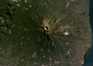 The summit craters of Iliboleng are near the center of this May 2019 Planet Labs satellite image monthly mosaic (N is at the top). The larger crater is approximately 500 x 700 m.
Satellite image courtesy of Planet Labs Inc., 2019 (https://www.planet.com/).
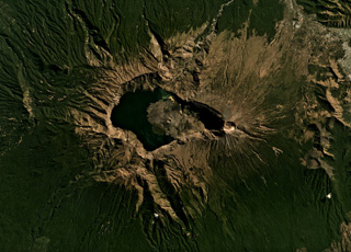 A lake partly fills the Segara Anak caldera (6 x 8.5 km wide, 800 m deep) of Rinjani volcano, shown here in this July 2019 Planet Labs satellite image monthly mosaic (N is at the top). The caldera formed during the 1257 eruption of Samalas volcano, the prior edifice. Barujari cone has formed within the caldera through a series of lava flow-producing eruptions. A roughly 1-km-wide crater is at the summit along the eastern side of the caldera.
Satellite image courtesy of Planet Labs Inc., 2019 (https://www.planet.com/).
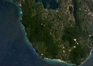 Pulau Weh island in shown in this July 2019 Planet Labs satellite image monthly mosaic (N is at the top; this image is approximately 9 km across). Lhok Perialakot bay to the north has been interpreted as the remains of an older collapsed edifice that opens to the NW and is filled by the sea.
Satellite image courtesy of Planet Labs Inc., 2019 (https://www.planet.com/).
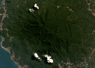 The modern Rajabasa edifice is composed of two edifices, the Rajabasa and Balerang cones, that formed within a 25-km-diameter caldera at the SSE tip of Sumatra Island. The complex is shown in this May 2019 Planet Labs satellite image monthly mosaic (N is at the top; the image is approximately 12 km across). The flanks are formed by lava flows erupted from the summit and flank vents, and flank collapse events have resulted in horseshoe-shaped scarps.
Satellite image courtesy of Planet Labs Inc., 2019 (https://www.planet.com/).
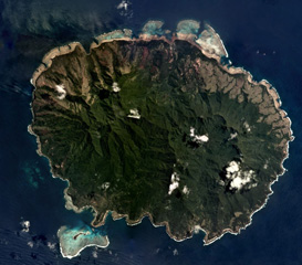 Aneityum Island is approximately 17 km long in the NE-SW direction, shown in this September 2019 Planet Labs satellite image monthly mosaic (N is at the top). Two main eroded edifices form the island, Nanawarez in the E and Inrerow Atamwan to the W, with a large horseshoe-shaped scarp that opens to the SE visible on Nanawarez.
Satellite image courtesy of Planet Labs Inc., 2019 (https://www.planet.com/).
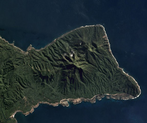 Traitor's Head Peninsula of Erromango Island is shown in this July 2019 Planet Labs satellite image monthly mosaic (N is at the top; this image is approximately 10 km across). Three eroded volcanic edifices are visible, Nagat to the NE, Rantop in the center, and Oulenou with the summit crater to the W.
Satellite image courtesy of Planet Labs Inc., 2019 (https://www.planet.com/).
 The northern part of the Efate island group in Vanuatu is shown in this September 2019 Planet Labs satellite image monthly mosaic (N is at the top; this image is approximately 22 km across). The three smaller islands are Nguna to the NW, immediately SE of that is Pele, and the island to the E is Emau. Several craters are visible on the islands, with a 900-m-wide crater on Emau.
Satellite image courtesy of Planet Labs Inc., 2019 (https://www.planet.com/).
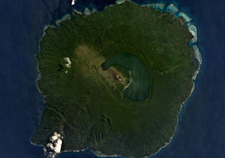 The 40-km-wide volcanic Guaya Island contains Lake Letas within a 6 x 8 km caldera in the center of this September 2019 Planet Labs satellite image monthly mosaic (N is at the top). The active Mount Garet formed within the caldera and has two summit craters; explosive eruptive activity occurred from the SE crater in 2009-2010. Smaller cones and lava flows have formed across the flanks.
Satellite image courtesy of Planet Labs Inc., 2019 (https://www.planet.com/).
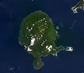 Vanua Lava Island of Vanuatu is shown in this February 2018 Planet Labs satellite image monthly mosaic (N is at the top; this image is approximately 40 km across). The majority of cones, craters, and features are in the northern part of the island, and comprise the Surematai volcano. The Pleistocene Ngere Kwon volcano formed the southernmost peninsula.
Satellite image courtesy of Planet Labs Inc., 2018 (https://www.planet.com/).
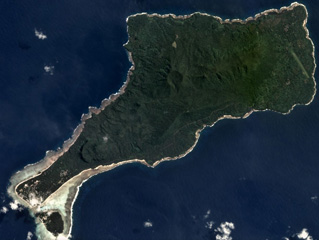 Motlav or Mota Lava island is part of the Vanuatu northern Banks Islands, shown in this April 2019 Planet Labs satellite image monthly mosaic (N is at the top; this image is approximately 12 km across). The NE-SW central ridge contains eroded late Pleistocene eruptive centers. Two younger cones are visible here, Tuntog near the center of this image and Vetman to the SW.
Satellite image courtesy of Planet Labs Inc., 2019 (https://www.planet.com/).
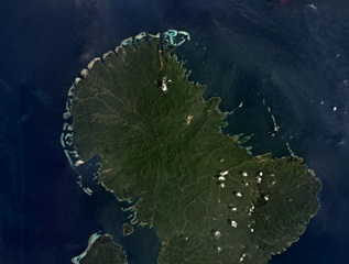 The Nonda volcanic center is on Vella Lavella Island in the Solomon Islands, near the center of this November 2019 satellite image monthly mosaic (N is at the top; this image is approximately 47 km across). It contains a lava dome and crater, and the nearby Paraso geothermal area remains active.
Satellite image courtesy of Planet Labs Inc., 2018 (https://www.planet.com/).
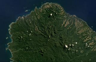 The Gallego Volcanic Field covers around 800 km2 on NW Guadalcanal Island, and 30 km2 on Savo to the N, with the former area shown in this June 2018 Planet Labs satellite image monthly mosaic (N is at the top; this image is approximately 27 km across). This image contains many eroded edifices, including Komambulu along the western shore (about halfway up the image). The Esperance volcanic center is at the northern end, and the Gallego volcanic ridge is to the SE.
Satellite image courtesy of Planet Labs Inc., 2018 (https://www.planet.com/).
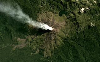 The flanks of Bagana are composed of radial lava flows that erupted from a central summit crater where a gas plume is emitting and dispersing NW, visible in this June 2019 Planet Labs satellite image monthly mosaic (N is at the top; this image is approximately 12 km across). At 2.5 km NW from the crater is a lava dome, and to the NE is the eroded Reini cone.
Satellite image courtesy of Planet Labs Inc., 2018 (https://www.planet.com/).
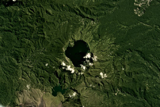 Billy Mitchell has produced some of the largest Holocene eruptions in Papua New Guinea, including the activity that produced the caldera in the center of this May 2018 Planet Labs satellite image monthly mosaic (N is at the top; this image is approximately 13 km across). Large eruptions around 900 and 370 years ago emplaced pyroclastic-flow and tephra deposits that reach 25 km away. Lava flows on the flanks of Bagana are to the lower left.
Satellite image courtesy of Planet Labs Inc., 2018 (https://www.planet.com/).
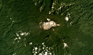 A series of craters have formed along a NW-SE-trending ridge on Balbi, seen in this January 2018 Planet Labs satellite image monthly mosaic (N is at the top; this image is approximately 15 km across). Part of the summit area is vegetation-free and geothermal activity continues.
Satellite image courtesy of Planet Labs Inc., 2018 (https://www.planet.com/).
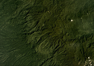 Lava flow morphologies are visible on the eroded, vegetated, flanks of Tore in NW Bougainville Island, Papua New Guinea, in this December 2019 Planet Labs satellite image monthly mosaic (N is at the top; this image is approximately 22 km across). The NW flank of Balbi volcano is in the lower right of this image.
Satellite image courtesy of Planet Labs Inc., 2019 (https://www.planet.com/).
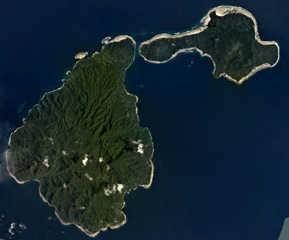 Ambitle Island is on the left and Babase Island is to the upper right in this February 2020 Planet Labs satellite image monthly mosaic (N is at the top; this image is approximately 21 km across). The 900 x 550 m Ambitle crater is near the center of the larger island and formed within a flank collapse scarp. Lava domes produced block-and-ash flow deposits and lava flows are also present.
Satellite image courtesy of Planet Labs Inc., 2020 (https://www.planet.com/).
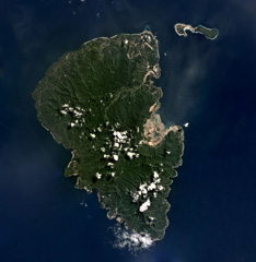 The 192 km2 Lihir Island, approximately 22 km long in the N-S direction, is shown in this July 2019 Planet Labs satellite image monthly mosaic (N is at the top). The Ladolam gold deposit open pit mine is visible on the E coast within the remains of Luise volcano that has undergone flank collapse, resulting in a 1-km-long debris avalanche deposit offshore. After the collapse event the gold deposit accumulated from hydrothermal fluids.
Satellite image courtesy of Planet Labs Inc., 2019 (https://www.planet.com/).
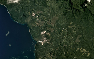 The Iamalele volcanic center on Fergusson Island is an active geothermal area (the white zones) seen in this May 2020 Planet Labs satellite image monthly mosaic (N is at the top; image is approximately 14 km across). The field contains lava domes and an ignimbrite deposit possibly related to caldera collapse.
Satellite image courtesy of Planet Labs Inc., 2020 (https://www.planet.com/).
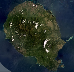 Goodenough Island is the westernmost of the D'Entrecasteaux Islands, Papua New Guinea, shown in this December 2019 Planet Labs satellite image monthly mosaic (N is at the top; this image is approximately 37 km across). The island has several cones around the outer perimeter of the island, surrounding the metamorphic rocks that form the center. The youngest features, such as the Wailagi Cones, are located on the Bwaido Peninsula to the SE.
Satellite image courtesy of Planet Labs Inc., 2019 (https://www.planet.com/).
 Mount Victory in Cape Nelson, Papua New Guinea, is shown in this July 2018 Planet Labs satellite image monthly mosaic (N is at the top; this image is approximately 20 km across). The vegetated flanks are eroded and four scoria cones are on the lower SW flank with several craters visible. The summit contains an irregular crater and there are two more cones on the NE flank.
Satellite image courtesy of Planet Labs Inc., 2018 (https://www.planet.com/).
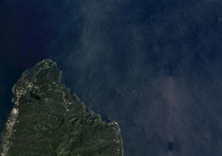 The 9-10 km wide Tavui Caldera off the Gazelle Peninsula in New Britain is along the NE coastline and up to 1.1 km below the ocean surface within the area shown in this November 2019 Planet Labs satellite image monthly mosaic (N is at the top; this image is approximately 14 km across). The caldera contains two cones, one 4.5 km wide in the northern area and the other 1.5 km wide in the northeastern area.
Satellite image courtesy of Planet Labs Inc., 2019 (https://www.planet.com/).
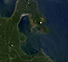 The 8 x 14 km Rabaul caldera is in the center of this September 2018 Planet Labs satellite image monthly mosaic (N is at the top), with several cones that have formed along the perimeter. Tavurvur is the unvegetated cone on the peninsula to the E, then to the NW of that is the crater of Palangiagia. The cone in the middle of the coastline within the harbor is Vulcan. The eroded cone to the north is Tovanumbatir.
Satellite image courtesy of Planet Labs Inc., 2018 (https://www.planet.com/).
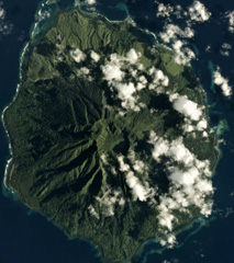 The 7.5 x 9 km Sakar is the NE-most of a chain of volcanic islands off the northern coast of Papua New Guinea, seen in this February 2017 Planet Labs satellite image monthly mosaic (N is at the top). The flanks are deeply eroded, but the summit crater contains a lake in the SE section and there is a cone on the S flank.
Satellite image courtesy of Planet Labs Inc., 2017 (https://www.planet.com/).
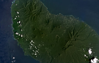 Umboi Island is around 50 km long in the NW-SE direction and has volcanic features visible in the NW, in the center of this January 2021 Planet Labs satellite image monthly mosaic (N is at the top; this image is approximately 40 km across). The larger crater near the top of the center of the island (N of the lake) is Bono of Soal volcano, and W is the eroded Barik cone. S of that is a NNW-SEE trend of craters named Pung, Talo, Apalong, and Tanglup from W to E.
Satellite image courtesy of Planet Labs Inc., 2021 (https://www.planet.com/).
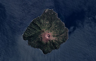 The roughly 3-km-wide Bam is an island volcano north of the main island of Papua New Guinea. The 300-m-wide, 180-m-deep summit crater is near the center of this May 2018 Planet Labs satellite image monthly mosaic (N is at the top). A NE-trending landslide scarp extends across the edifice from the SW coast.
Satellite image courtesy of Planet Labs Inc., 2018 (https://www.planet.com/).
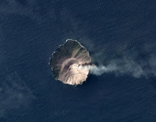 A plume at Kadovar is dispersing to the E in this November 2019 Planet Labs satellite image monthly mosaic (N is at the top). The flanks of the roughly 1.4 x 1.6 km island have been stripped of vegetation due to lava dome formation and collapse at the summit, with recent eruptive activity producing ash plumes and pyroclastic flows. Activity has also recently occurred at the base of the SE flank.
Satellite image courtesy of Planet Labs Inc., 2019 (https://www.planet.com/).
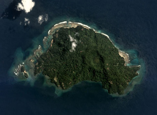 The roughly 3.5-km-wide Blup Blup is north of the main Papua New Guinea island. The summit crater near the center of the island is visible in this August 2019 Planet Labs satellite image monthly mosaic (N is at the top). A small flank cone is on the SW coast and a submarine debris avalanche deposit is to the NE.
Satellite image courtesy of Planet Labs Inc., 2019 (https://www.planet.com/).
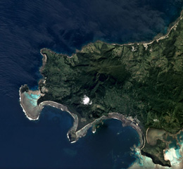 The Nabukelevu lava-dome complex formed at the SW end of Kadavu Island at the S end of the Fiji archipelago, and is shown in this May 2019 Planet Labs satellite image monthly mosaic (N is at the top; this image is approximately 10 km across). The complex has produced several debris avalanche deposits through flank collapse and block-and-ash flow deposits from dome collapse.
Satellite image courtesy of Planet Labs Inc., 2019 (https://www.planet.com/).
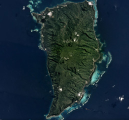 The 17-km-long Koro Island in Fiji is located between Viti Levu and Vanua Levu Islands, and is shown in this May 2018 Planet Labs satellite image mosaic (N is at the top). Late Pleistocene or possibly Holocene age scoria cones formed along the crest of the island, and younger lava flows are in the central plateau.
Satellite image courtesy of Planet Labs Inc., 2018 (https://www.planet.com/).
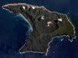 Raoul Island in the Kermadec Islands has two main calderas, one in the center of the island (Raoul Caldera) and one forming the linear western shoreline (Denham Caldera), shown in this November 2019 Planet Labs satellite image monthly mosaic (N is at the top; this image is approximately 11 km across). The Blue (upper) and Green (lower) lakes are within Raoul Caldera, with the 1964 crater along the NW edge of the Green Lake.
Satellite image courtesy of Planet Labs Inc., 2019 (https://www.planet.com/).
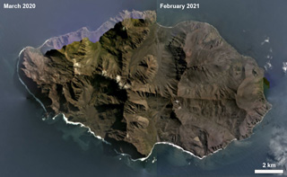 The 17.5-km-wide Ile de l' Est in the Crozet Archipelago is shown in this combined March 2020/February 2021 Planet Labs satellite image monthly mosaics. The island is largely eroded by glaciation and also contains younger scoria cones, most of which are on the eastern side.
Satellite image courtesy of Planet Labs Inc., 2021 (https://www.planet.com/).
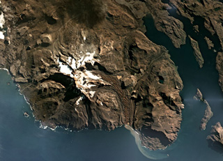 The Kerguelen Islands are part of an extensive Large Igneous Province, and are composed largely of extensive lava flows, exposed intrusive rock, and several volcanic centers such as Mount Ross which is shown in this April 2019 Planet Labs satellite image monthly mosaic (N is at the top; this image is approximately 30 km across). The Buffon glacier is on the eastern flank and immediately E of where it turns S is the flat-topped remnant of a lava lake.
Satellite image courtesy of Planet Labs Inc., 2019 (https://www.planet.com/).
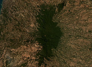 The Ambre-Bobaomby volcanic field forms the northernmost region of Madagascar, shown in this July 2019 Planet Labs satellite image monthly mosaic (N is at the top; this image is approximately 47 km across). The edifice shown here is the Massif d’Ambre, and the Bobaomby field continues to the north. The Massif d’Ambre contains lava flows, spatter cones, tuff rings, pyroclastic flow deposits, and tephra, with some craters visible down the apex of the N-S trending edifice.
Satellite image courtesy of Planet Labs Inc., 2019 (https://www.planet.com/).
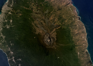 Karthala shield volcano forms the southern two-thirds of Grand Comore Island, NW of Madagascar in the Indian Ocean. The summit caldera is near the center of this August 2019 Planet Labs satellite image monthly mosaic (N is at the top; this image is approximately 25 km across). Lava flows reach the ocean on both sides from summit and flank vents, and rift zones propogate to the SE and NW from the caldera.
Satellite image courtesy of Planet Labs Inc., 2019 (https://www.planet.com/).
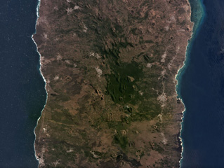 La Grille shield volcano forms the northern third of Grand Comore Island NW of Madagascar, with the larger Karthala forming the southern portion. The island is around 15 km wide in the area pictured. Numerous scoria cones can be seen across the summit region and flanks in this September 2019 Planet Labs satellite image monthly mosaic (N is at the top. Several tuff rings have formed along the northern coast.
Satellite image courtesy of Planet Labs Inc., 2019 (https://www.planet.com/).
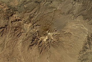 Taftan volcano in SE Iran has extensively eroded flanks composed of lava flows, pyroclastic flows, and ignimbrite deposits, shown in this October 2019 Planet Labs satellite image monthly mosaic (N is at the top; this image is approximately 42 km across). It has two main edifices, Narkuh and Matherkuh, and geothermal activity continues in the summit region.
Satellite image courtesy of Planet Labs Inc., 2019 (https://www.planet.com/).
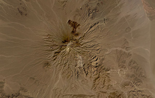 Bazman volcano is part of the Makran arc in SE Iran, shown here in this October 2019 Planet Labs satellite image monthly mosaic (N is at the top; this image is approximately 44 km across). Scoria cones and lava flows have formed across the eroded flanks, with several darker lava flows containing levees and lobate flow fronts visible on the northern flank. The Bazman granitoid complex forms part of the southern flank and formed between 83 and 72 million years ago.
Satellite image courtesy of Planet Labs Inc., 2019 (https://www.planet.com/).
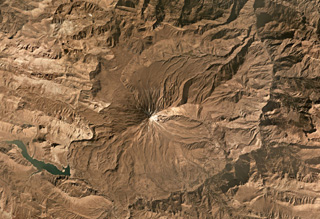 Damavand is largely composed of pyroclastic flow deposits, tephra, and radial lava flows that have erupted mostly from summit vents to form the steep flanks. The summit is near the center of this October 2019 Planet Labs satellite image monthly mosaic (N is at the top; this image is approximately 40 km across). The current cone has formed over the remains of an older cone.
Satellite image courtesy of Planet Labs Inc., 2019 (https://www.planet.com/).
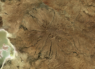 Sahand in NW Iran has heavily eroded flanks, seen in this October 2019 Planet Labs satellite image monthly mosaic (N is at the top; this image is approximately 150 km across). A caldera formed at the summit which has been largely infilled by more recent activity. Eruptive deposits from Sahand were emplaced over an area of around 3,000 km2 and lava domes and smaller cones have formed across the flanks.
Satellite image courtesy of Planet Labs Inc., 2019 (https://www.planet.com/).
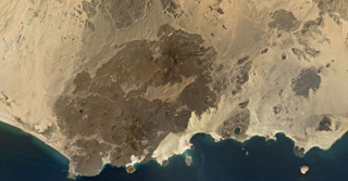 The 500 km2 Balhaf-Bir Ali Volcanic Field in south Yemen is shown in this February 2020 Planet Labs satellite image monthly mosaic (N is at the top; this image is approximately 45 km across). The field largely comprises lava flows and spatter and scoria cones, tuff rings, and the At-Tabâb maar with a crater lake along the shoreline. The Balhaf cone is the darker area to the S with the cross-roads just below it, and the darker area in the northern part of the field is the Jabal Ba Masha’ib.
Satellite image courtesy of Planet Labs Inc., 2020 (https://www.planet.com/).
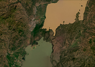 A group of Tosa Sucha scoria cones are near the northern shore of Lake Chamo, the green lake at the bottom of this December 2020 Planet Labs satellite image monthly mosaic (N is at the top; this image is approximately 44 km across). The cones erupted in and around the intensely faulted area between the lakes, and within Lake Chamo.
Satellite image courtesy of Planet Labs Inc., 2020 (https://www.planet.com/).
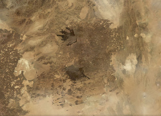 The roughly 6,000 km2 Harrat Kishb volcanic field is shown in this November 2019 Planet Labs satellite image monthly mosaic (N is at the top; this image is approximately 180 km across). The field is comprised of scoria cones, tuff rings, maars, lava domes, and flows. Along the western edge of the lower black lava flow field is the Al Wahbah maar, one of the largest in the Arabian Peninsula at 2.3 km wide.
Satellite image courtesy of Planet Labs Inc., 2019 (https://www.planet.com/).
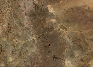 The northern part of the 20,000 km2 Harrat Rahat volcanic field, the largest in Saudia Arabia at 50-75 km wide and ~300 km long, is shown in this November 2019 Planet Labs satellite image monthly mosaic (N is at the top; this image is approximately 192 km across). Earlier work identified 986 vents across the field. Recent lava flows in the northern end encroach on the city of Al-Madinah.
Satellite image courtesy of Planet Labs Inc., 2019 (https://www.planet.com/).
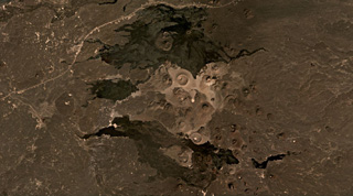 The central area of the 14,000 km2 Harrat Khaybar volcanic field is shown in this December 2020 Planet Labs satellite image monthly mosaic (N is at the top; this image is approximately 49 km across). This area contains tuff rings and maars from phreatomagmatic activity and scoria cones, with some more recent lava flows. The larger light-colored crater near the center is Jabal Bayda, and the cone that produced the black lava flows to the north is Jabal Qidr.
Satellite image courtesy of Planet Labs Inc., 2020 (https://www.planet.com/).
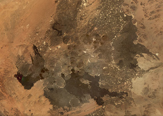 The 4,000 km2 Harrat Ithnayn volcanic field covers much of this November 2019 Planet Labs satellite image monthly mosaic (N is at the top; this image is approximately 94 km across). Scoria cones are visible across the field, with the Jabal Hazam Khadra’ cone is at the bottom of the center of the image. The lava flows are different shades dependending on variable amounts of weathering, erosion, and the amount of sedimentation on the surface.
Satellite image courtesy of Planet Labs Inc., 2019 (https://www.planet.com/).
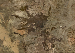 The Harrat Lunayyir volcanic field contains around 50 identified craters with numerous lava flows seen in this November 2019 Planet Labs satellite image monthly mosaic (N is at the top; this image is approximately 89 km across). The scoria cones contain summit craters and many experienced flank collapse or rafting during the eruptions, resulting in horseshoe-shaped craters. The youngest lavas occur in the central part of the field and cover 25 km2.
Satellite image courtesy of Planet Labs Inc., 2019 (https://www.planet.com/).
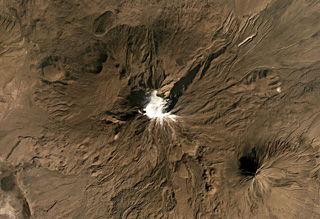 Mount Ararat has two main edifices, the glaciated Buyuk Ağrı in the center and the smaller Kucuk Ağri to the SE of this October 2019 Planet Labs satellite image monthly mosaic (N is at the top; this image is approximately 33 km across). The flanks are lava flows, lava domes, craters, and explosive deposits.
Satellite image courtesy of Planet Labs Inc., 2019 (https://www.planet.com/).
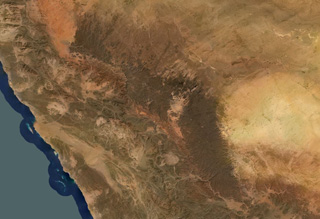 Harrat ar Rahah-'Uwayrid is the northernmost of a series of Quaternary volcanic fields paralleling the Red Sea coast of Saudi Arabia, south of the city of Tabuk. The olivine basaltic field extends NW-SE about 240 km overall, and contains numerous scoria cones, tuff cones, and associated lava fields.
Satellite image courtesy of Planet Labs Inc., 2020 (https://www.planet.com/).
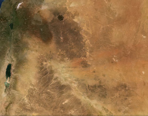 The 100,000 km2 Harrat Ash Shaam volcanic field extends from the NW corner to the SE corner of this February 2021 Planet Labs satellite image monthly mosaic (N is at the top; this image is approximately 480 km across). The Harrat contains several volcanic fields including Al Harrah, Jabal ad Druze, Es Safa, Golan Heights, and the Kra Lava Field.
Satellite image courtesy of Planet Labs Inc., 2021 (https://www.planet.com/).
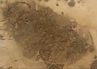 The 480 km2 Bayuda Volcanic Field in Sudan contains around 70 small volcanic centers including at least 53 scoria cones and 15 maar craters, shown in this November 2019 Planet Labs satellite image monthly mosaic (N is at the top; this image is approximately 46 km across). The field was partly constructed over Precambrian and Paleozoic granite, which form darker areas to the SE.
Satellite image courtesy of Planet Labs Inc., 2019 (https://www.planet.com/).
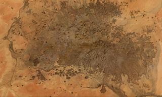 The Meidob Volcanic Field covers approximately 5,000 km2 in western Sudan, seen in this November 2019 Planet Labs satellite image monthly mosaic (N is at the top; this image is approximately 100 km across). Around 700 features have been identified, including scoria cones, maars, tuff rings, and eroded features. Some lava flows reached more than 20 km from their source.
Satellite image courtesy of Planet Labs Inc., 2019 (https://www.planet.com/).
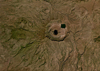 The 5-7 km Deriba caldera is part of the Jebel Marra volcanic field, located in the Darfur province of western Sudan, shown in this November 2019 Planet Labs satellite image monthly mosaic (N is at the top). It formed during an eruption 3,500 years ago that produced pyroclastic flows reaching 30 km away. The central lake is within the crater of a smaller cone.
Satellite image courtesy of Planet Labs Inc., 2019 (https://www.planet.com/).
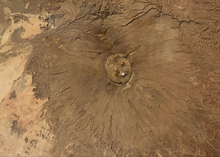 Emi Koussi is the largest volcano of the Tibesti massif in Chad, with a diameter of 60-70 km and a summit crater approximately 13.5 x 11 km in size, seen in this this November 2019 Planet Labs satellite image monthly mosaic (N is at the top; this image is approximately 92 km across). Smaller cones and vents can be seen within the caldera and on the flanks.
Satellite image courtesy of Planet Labs Inc., 2019 (https://www.planet.com/).
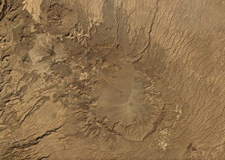 The Tarso Voon caldera within the Tibesti massif in Chad is shown in this November 2019 Planet Labs satellite image monthly mosaic (N is at the top; this image is approximately 48 km across). The Soborom geothermal field is on the W flank and several smaller cones and craters are visible along the N flank.
Satellite image courtesy of Planet Labs Inc., 2019 (https://www.planet.com/).
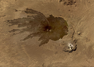 Tarso Toussidé is a nested caldera system in the Tibesti massif in Chad, seen in this November 2019 Planet Labs satellite image monthly mosaic (N is at the top; this image is approximately 44 km across). Trou au Natron is the caldera along the SE boundary, the crater to the NNE is Petit Trou/Doon Kidimi. The long, narrow lava flow to the NW is one of the more recent eruptive products.
Satellite image courtesy of Planet Labs Inc., 2019 (https://www.planet.com/).
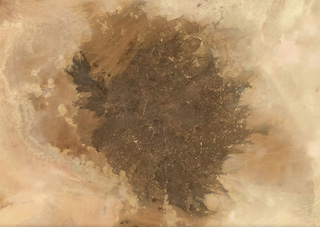 The Al Haruj volcanic province covers around 42,000 km2 in Libya, shown in this November 2019 Planet Labs satellite image monthly mosaic (N is at the top; this image is approximately 350 km across). It contains numerous lava flows, scoria cones, spatter cones, vents including maars, and 47 identified dike segments.
Satellite image courtesy of Planet Labs Inc., 2019 (https://www.planet.com/).
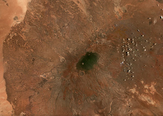 The 6,300 km2 Marsabit volcanic field contains around 550 identified features including cones, vents, and maar craters, shown in this September 2019 Planet Labs satellite image monthly mosaic (N is at the top; this image is approximately 100 km across). The crater immediately south of the darker area in the center of the image is approximately 2.5 km in diameter.
Satellite image courtesy of Planet Labs Inc., 2019 (https://www.planet.com/).
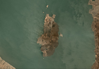 The South Island is the southernmost of three volcanic islands within Lake Turkana in northern Kenya, at 11 x 5.5 km plus smaller islands around the main exposed landmass, seen here in this September 2019 Planet Labs satellite image monthly mosaic (N is at the top). Lava flows form much of the surface and a fissure runs along the center of the island. Smaller cones and craters are also visible, with a larger crater at the northern end of the island.
Satellite image courtesy of Planet Labs Inc., 2019 (https://www.planet.com/).
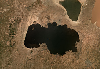 The eastern side of Lake Shala formed within the 17-km-wide O'a caldera, shown in this November 2019 satellite image monthly mosaic (N is at the top; this image is approximately 50 km across). The western part of the lake formed in a fault-controlled basin. The lake-filled Chitu maar is near the SW side of the Lake Shala.
Satellite image courtesy of Planet Labs Inc., 2019 (https://www.planet.com/).
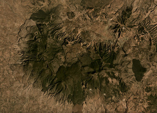 Aluto is a caldera in Ethiopia with features including lava flows, pumice cones, explosive deposits, and 96 identified vents within and around the caldera, shown in this November 2019 satellite image monthly mosaic (N is at the top; this image is approximately 12 km across). Darker obsidian lava flows are visible around the 6 x 9 km caldera.
Satellite image courtesy of Planet Labs Inc., 2019 (https://www.planet.com/).
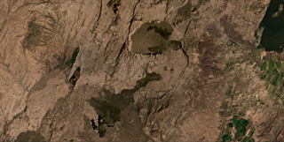 The caldera complex and recent lava flows of the Kone volcanic complex are shown in this January 2021 Planet Labs satellite image monthly mosaic (N is at the top; this image is approximately 37 km across). The Kone Caldera with the Korke embayment are filled with lavas from vents, with more recent flows from the eastern rim area. More recent lava flows were emplaced to the SW and NE.
Satellite image courtesy of Planet Labs Inc., 2021 (https://www.planet.com/).
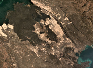 The Ardoukôba Rift is in Djibouti at the NW end of Lake Ghoubet (lower right) and is shown in this October 2019 Planet Labs satellite image monthly mosaic (N is at the top; this image is approximately 11 km across). It contains lava flows from scoria and spatter cones, with recent deposits erupted in 1978.
Satellite image courtesy of Planet Labs Inc., 2019 (https://www.planet.com/).
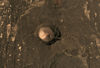 The 2.5 x 3.5 km Mat Ala caldera is in the center of this November 2019 Planet Labs satellite image monthly mosaic (N is at the top). It is SE of Tat Ali and Erta Ale in Ethiopia, and N-S-trending faults are visible across the flanks.
Satellite image courtesy of Planet Labs Inc., 2019 (https://www.planet.com/).
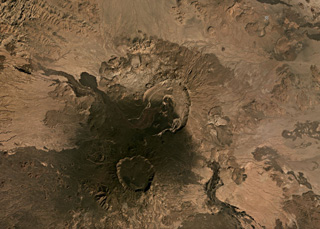 This November 2019 Planet Labs satellite image monthly mosaic shows several calderas and lava flows, with Nabro in the center and Mallahle below it, both within the Bidu Volcanic Complex of the Nabro Volcanic Range (N is at the top). The 6-km-diameter-wide Mallahle caldera contains obsidian lava flows in the northern part. Sork’Ale is partly visible to the SE.
Satellite image courtesy of Planet Labs Inc., 2019 (https://www.planet.com/).
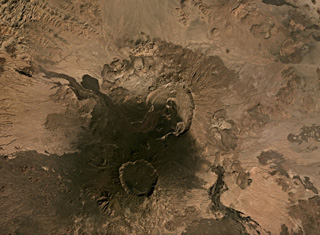 This November 2019 Planet Labs satellite image monthly mosaic shows several calderas and lava flows, with Nabro in the center and Mallahle below it within the Bidu Volcanic Complex (N is at the top). The 8-km-wide Nabro summit caldera opens towards the S, and the darker lava flow towards the NWW was erupted in 2011.
Satellite image courtesy of Planet Labs Inc., 2019 (https://www.planet.com/).
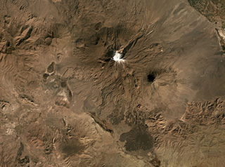 Mount Ararat, or the Ağri Daği volcanic complex, in Turkey has two main edifices, Buyuk Ağrı near the center of this image and the smaller Kucuk Ağri to the SE, both seen in this October 2019 Planet Labs satellite image monthly mosaic (N is at the top; this image is approximately 40 km across). Large recent lava flows form the darker areas to the S of the main glaciated cone.
Satellite image courtesy of Planet Labs Inc., 2019 (https://www.planet.com/).
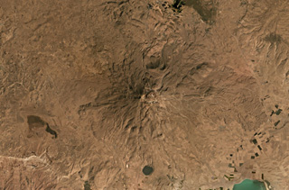 Süphan Dagi in Turkey is in the center of this September 2019 Planet Labs satellite image monthly mosaic (N is at the top; this image is approximately 40 km across). To the south is Aygirgölü maar which is just under 2 km in diameter. Lava flows are visible across the eroded flanks.
Satellite image courtesy of Planet Labs Inc., 2019 (https://www.planet.com/).
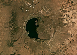 The eastern half of the 8.5 × 7 km Nemrut Dagi summit caldera is partially filled with lava flows, phreatomagmatic eruption deposits, and lava domes, and the western half is filled with a lake that is seen in this June 2019 Planet Labs satellite image monthly mosaic (N is at the top). The surrounding area contains ignimbrite deposits, tephra, lava domes, and lava flows.
Satellite image courtesy of Planet Labs Inc., 2019 (https://www.planet.com/).
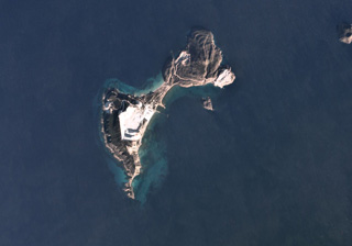 Yali is the uppermost part of a submerged caldera and is part of the Nisyros volcanic field. The SW part of the 4-5 km island is composed of the Lower and Upper Pumice deposits, and the NE area consists of lave domes, seen in this December 2019 Planet Labs satellite image monthly mosaic (N is at the top). The pumice quarry in the SW exposes pumice deposits in 60-100 m thick sections.
Satellite image courtesy of Planet Labs Inc., 2019 (https://www.planet.com/).
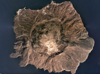 Nisyros has a 3.6-km-diameter caldera with walls 300-400 m high and is filled with lava domes, seen here in this September 2019 Planet Labs satellite image monthly mosaic (N is at the top). The edifice also has vents, scoria cones, dikes, fault systems, and geothermal features, including active fumaroles and hot springs.
Satellite image courtesy of Planet Labs Inc., 2019 (https://www.planet.com/).
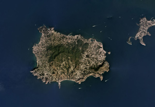 The Ischia volcanic complex forms a 6 x 9 km island in the Bay of Naples and is part of the Phlegraean Volcanic District. It is shown in this September 2019 Planet Labs satellite image monthly mosaic (N is at the top). The vegetated area is a resurgent block and the high point of the island. An arcuate collapse scarp in near the center on the island, opening towards the south.
Satellite image courtesy of Planet Labs Inc., 2019 (https://www.planet.com/).
 Basaltic lava flows are exposed in the valley across the center of this January 2021 Planet Labs satellite image monthly mosaic (N is at the top; this image is approximately 61 km across). The valley is a tributary of Río Murta to the W. The flows were emplaced partly subglacially in glacial valleys cutting granitic rocks of the North Patagonian Batholith in the southern Andes. Lava flow features include columnar jointing, pillow lavas, and lava tubes.
Satellite image courtesy of Planet Labs Inc., 2021 (https://www.planet.com/).
 Cuernos del Diablo is a small glacially eroded edifice in Chile, seen here in this 26 March 2019 Planet Scope satellite image (N is at the top; this image is approximately 9.5 km across). The volcano formed numerous smaller cones and lava flows during the Holocene.
Satellite image courtesy of Planet Labs Inc., 2019 (https://www.planet.com/).
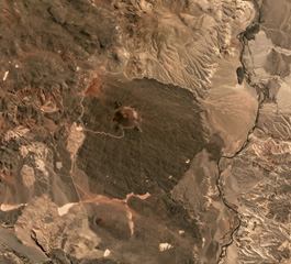 The Cochiquito Volcanic Group includes this scoria cone and lava field, seen in this October 2019 Planet Labs satellite image monthly mosaic (N is at the top). The N-S length of this lava field is approximately 7 km and the crater is approximately 250 m in diameter.
Satellite image courtesy of Planet Labs Inc., 2019 (https://www.planet.com/).
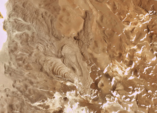 The Cerro Bayo volcanic complex is along the Chile-Argentina border east of the Salar de Gorbea and is shown in this 21 October 2019 Planet Scope satellite image (N is at the top; the image is approximately 11.5 km across). A 430-m-diameter crater is visible at the summit of a scoria cone, and to the W are lobate lava flows with levees and pressure ridges.
Satellite image courtesy of Planet Labs Inc., 2019 (https://www.planet.com/).
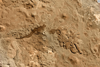 Cordón del Azufre is in the center of this 22 May 2019 Planet Scope satellite image (N is at the top), located along the Chile-Argentina border. The darker lava flow originated from Volcán la Moyra, the youngest feature of the volcanic field, reaching 6 km to the W. The complex includes a N-S chain of four craters and numerous lava flows.
Satellite image courtesy of Planet Labs Inc., 2019 (https://www.planet.com/).
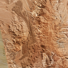 An elongated lava flow field at La Negrillar is down the center of this 28 April 2019 Planet Scope satellite image (N is at the top; this image is approximately 17 km across). A scoria cone with a crater that opens towards the SE is visible below the center of the image. The field is located along the SW margin of the Atacama basin, W of Socompa volcano.
Satellite image courtesy of Planet Labs Inc., 2019 (https://www.planet.com/).
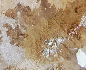 Pular is the 12-km-long volcanic ridge below the center of this 29 October 2018 Planet Scope image (N is at the top; this image is approximately 41 km across). The lava flows to the W are at El Negrillar. The edifice contains Cerro Pular at the NE end and Cerro Pajonales at the SW.
Satellite image courtesy of Planet Labs Inc., 2018 (https://www.planet.com/).
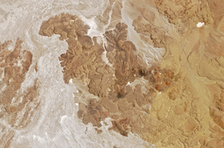 Lava flows and scoria cones of El Negrillar are shown in this 29 October 2018 Planet Labs Rapid Eye satellite image (N is at the top; the image is approximately 22 km across). The lighter area to the W of the lava flows is part of the major Holocene debris avalanche from Socompa volcano.
Satellite image courtesy of Planet Labs Inc., 2018 (https://www.planet.com/).
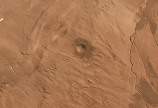 Cerro Tujle maar is the crater in the center of this March 2019 Planet Labs satellite image monthly mosaic (N is at the top), located in the Central Volcanic Zone of the northern Chilean Andes. The 333 x 279 m crater is 60 m deep, and around it are tephra and lava flows.
Satellite image courtesy of Planet Labs Inc., 2019 (https://www.planet.com/).
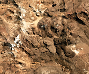 Four cones of the Nevados Casiri complex are seen in this July 2019 Planet Labs satellite image monthly mosaic (N is at the top; the image is approximately 11 km across). The three older cones are in a E-W trend, and the younger SE cone has a crater containing a dome along with two lava flows to the S and SE with visible levees and pressure ridges.
Satellite image courtesy of Planet Labs Inc., 2019 (https://www.planet.com/).
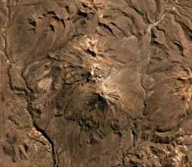 Volcán Yucamane is composed of three main edifices, Yucamane Chico to the N, El Calientes in the middle, and Volcán Yucamane at the southern end, seen in this July 2019 Planet Labs satellite image monthly mosaic (N is at the top; the image is approximately 19.5 km across). Levees and pressure ridges are visible on lobate lava flows on the flanks.
Satellite image courtesy of Planet Labs Inc., 2019 (https://www.planet.com/).
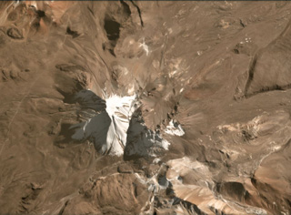 Tutupaca consists of two eroded edifices that are seen in the center of this July 2020 Planet Labs satellite image monthly mosaic (N is at the top; the image is approximately 10 km across). The complex contains lava domes and a number of these have undergone collapse. The eastern edifice has a horseshoe-shaped collapse scarp that opens towards the NE.
Satellite image courtesy of Planet Labs Inc., 2020 (https://www.planet.com/).
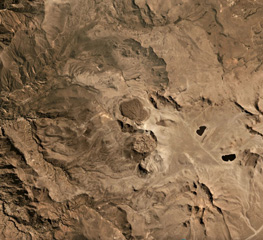 Lava domes of Ticsani volcano are shown in the center of this August 2019 Planet Labs satellite monthly mosaic (N is at the top). The previous edifice collapsed to form an estimated 12 km3 debris avalanche deposit and has since emplaced these lava domes. This image is approximately 18.5 km across.
Satellite image courtesy of Planet Labs Inc., 2019 (https://www.planet.com/).
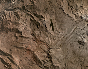 Several scoria cones of the Huambo volcanic field are visible in this July 2020 Planet Labs satellite image monthly mosaic (N is at the top; the image is approximately 40 km across). It has a northern and a southern field and contains up to 60 cones that span 300 to 1,200 m in diameter and up to 300 m in height. The upper area of this image N of the lake contains lava flows erupted from Cerro Keyocc the northern part of the field.
 Satellite image courtesy of Planet Labs Inc., 2020 (https://www.planet.com/).
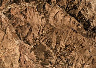 A lava flow at Quimsachata scoria cone is visible in this October 2020 Planet Labs satellite image monthly mosaic (N is at the top). The flow erupted about 11,500 years ago and is approximately 4.7 km in the NW-SE direction. The smaller lava flow directly to the north was erupted from the Oroscocha lava dome about 6,400 years ago. These are the northernmost young volcanic centers in Perú.
Satellite image courtesy of Planet Labs Inc., 2020 (https://www.planet.com/).
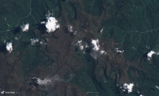 The Aliso volcanic complex is composed of lava domes, dome collapse deposits, ignimbrites, lava flows, and lahar deposits. The area is shown in this 4 September 2019 Sentinel-2 satellite image, which is approximately 12 km across. It is located in the jungle east of the town of Baeza in Ecuador.
Satellite image courtesy of Planet Labs Inc., 2019 (https://www.planet.com/).
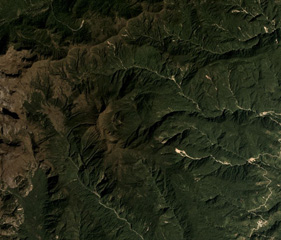 Volcán el Soche is a small volcano near the Ecuador-Colombia border and is seen in the center of this December 2017 Planet Labs satellite image monthly mosaic (N is at the top; this image is approximately 9.5 km across). Soche is the northernmost of a chain of Ecuadorian volcanoes east of the principal volcanic axis and was the source of a major explosive eruption during the early Holocene.
Satellite image courtesy of Planet Labs Inc., 2018 (https://www.planet.com/).
 Volcán Azul consists of three scoria cones on the Atlantic coastal plain of Nicaragua, one of which is seen in the center of this October 2017 Planet Labs satellite image monthly mosaic (N is at the top). They each have craters 50-60 m across; the cone in the center has a basal diameter of approximately 410 m.
Satellite image courtesy of Planet Labs Inc., 2017 (https://www.planet.com/).
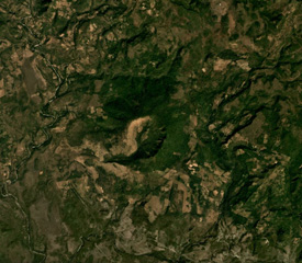 Cerro el Ciguatepe is in the center of this Planet Labs December 2019 satellite image monthly mosaic (N is at the top). It has a roughly 1.3-km-wide crater than opens towards the SW and a small lava flow extends a short distance beyond it.
Satellite image courtesy of Planet Labs Inc., 2019 (https://www.planet.com/).
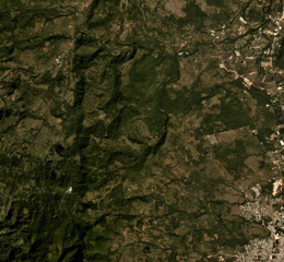 The area NW of the town of Estelí (lower right) contains vegetated lava flows of the Estelí volcanic field, shown in this December 2019 Planet Labs satellite image monthly mosaic (N is at the top; the image is approximately 10 km across). They were mostly erupted from vents in valleys within the northern interior highlands of Nicaragua between the town of Estelí and the border with Honduras.
Satellite image courtesy of Planet Labs Inc., 2019 (https://www.planet.com/).
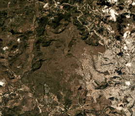 El Pedregal is near the center of this January 2019 Planet Labs satellite image monthly mosaic (N is at the top; the image is approximately 10 km across. Remnants of lava flows and separate vents occur over broad areas to the W and NW, and the capital city of Tegucigalpa is to the E.
Satellite image courtesy of Planet Labs Inc., 2019 (https://www.planet.com/).
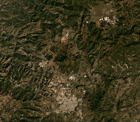 The Jumay Volcanic Field includes the cone in the center of this December 2019 Planet Labs satellite image monthly mosaic (N is at the top; the image is approximately 20 km across), N of Jalapa city. This cone has a shallow crater and eroded flanks.
Satellite image courtesy of Planet Labs Inc., 2019 (https://www.planet.com/).
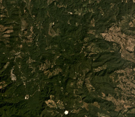 The Pleistocene Piedra Grande is the topographically indistinct area in the center of this December 2019 Planet Labs satellite image monthly mosaic (N is at the top; image is approximately 14 km across). The complex consists of heavily eroded, faulted cones, and has undergone extensive hydrothermal alteration.
Satellite image courtesy of Planet Labs Inc., 2019 (https://www.planet.com/).
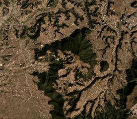 Cuxliquel volcano forms the triangular vegetated area in the center of this Planet Labs December 2019 satellite image monthly mosaic (N is at the top; the image is approximately 10 km across). The smaller vegetated area to the E is the Cerro de Oro lava dome. The surrounding area is the city of Quetzaltenango.
Satellite image courtesy of Planet Labs Inc., 2019 (https://www.planet.com/).
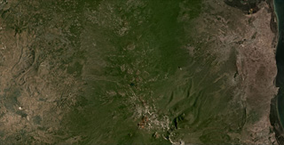 The Ghegam Volcanic Ridge can be seen through the center of this July 2020 Planet Labs satellite image monthly mosaic (N is at the top; this image is approximately 55 km across). Around 127 identified volcanic centers, including lava domes and cones, span an area 65 km long and 35 km wide in Armenia, west of Lake Sevan.
Satellite image courtesy of Planet Labs Inc., 2020 (https://www.planet.com/).
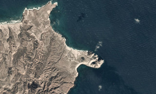 Punta Púlpito is an obsidian lava dome on the peninsula near the center of this 1 December 2019 Planet Scope satellite image (N is at the top). The dome is about 0.5 million years old and geothermal activity continues in the area. This image is approximately 6 km across.
Satellite image courtesy of Planet Labs Inc., 2019 (https://www.planet.com/).
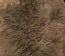 The eroded, Pleistocene San Ignacio Volcanic field in Baja Mexico contains dozens of scoria cones and lava flows. The area is shown in this December 2019 Planet Labs satellite image monthly mosaic (N is at the top), which is approximately 52 km across.
Satellite image courtesy of Planet Labs Inc., 2019 (https://www.planet.com/).
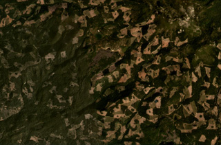 A lava flow from the Silver Lake scoria cone is visible in this September 2020 satellite image monthly mosaic (N is at the top; this image is approximately 10 km across). Lava flows that erupted from the Silver Lake scoria cone dammed drainages, forming Silver and Author lakes.
Satellite image courtesy of Planet Labs Inc., 2020 (https://www.planet.com/).
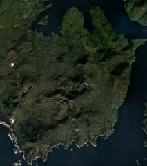 Lava flows of the Tlevak Strait-Suemez Island volcanic group are located near Tlevak Strait (lower right) and on the SW end of Suemez Island. The largest deposits are located north of Trocadero Bay, the large embayment on the southern side of Suemez Island.
Satellite image courtesy of Planet Labs Inc., 2019 (https://www.planet.com/).
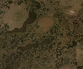 The Ingakslugwat Hills volcanic field covers an area of more than 500 km2 and contains over 32 scoria cones and 8 larger craters, some of which are seen in this Planet Labs June 2019 satellite image monthly mosaic (N is at the top; image is approximately 40 km across).
Satellite image courtesy of Planet Labs Inc., 2019 (https://www.planet.com/).
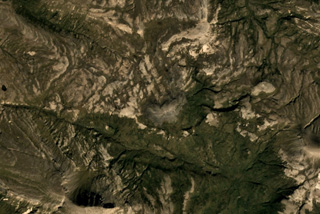 A small unnamed lava dome and an associated lava flow is located near the center of this Planet Labs September 2019 satellite image mosaic (N is at the top). The dome lies near the head of Big Alinchak Creek, NW of Alinchak Bay, and does not show evidence of glacial erosion.
Satellite image courtesy of Planet Labs Inc., 2019 (https://www.planet.com/).
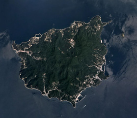 Ulreung volcano forms this small 12-km-wide island about 100 km east of the coast of the central Korean Peninsula. The extensively eroded edifice is seen in this Planet Labs June 2019 satellite image mosaic (N is at the top). It contains a caldera and was the site of a major explosive eruption at the beginning of the Holocene that produced pyroclastic flows and deposited ash across the Sea of Japan.
Satellite image courtesy of Planet Labs Inc., 2019 (https://www.planet.com/).
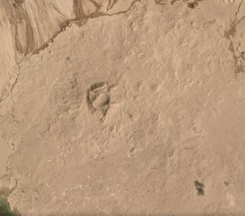 The Kunlun Volcanic Group in NW Tibet contains at least 70 cones. The cone just above the center of this image is the Ashi cone, which erupted lava across 33 km2 in 1951. Other cones are visible in the Ashikule Basin, the relatively flat area across this image.
Satellite image courtesy of Planet Labs Inc., 2019 (https://www.planet.com/).
 Tri Sestry volcano has an eroded edifice consisting of the Tri Sestry cone with a lava dome at the summit and a 1-km-diameter crater on the NW slope, along with another edifice. The complex is seen here along the coastline of Urup Island, in this September 2019 Planet Labs satellite image mosaic (N is at the top), which is approximately 20 km across.
Satellite image courtesy of Planet Labs Inc., 2019 (https://www.planet.com/).
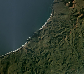 Rudakov volcano contains a 300-m-wide lake within the summit crater, visible near the center of this October 2019 Planet Labs satellite image mosaic (N is at the top). It is located along the W coast of central Urup Island in the Kurils.
Satellite image courtesy of Planet Labs Inc., 2019 (https://www.planet.com/).
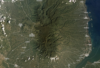 The eroded Malindang edifice is shown in this February 2018 Planet Labs image (N is at the top), near Iligan Bay in Mindanao.
Satellite image courtesy of Planet Labs Inc., 2018 (https://www.planet.com/).
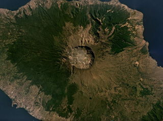 The 6-km-wide and 1-km-deep Tambora caldera that formed during the 1815 eruption is seen in this July 2019 Planet Labs satellite image mosaic (N is at the top). The 1815 eruption ejected around 41 km3 of magma and formed pyroclastic flows that reached the sea on all sides of the 60-km-wide volcanic peninsula of Sumbawa Island, triggering a tsunami.
Satellite image courtesy of Planet Labs Inc., 2019 (https://www.planet.com/).
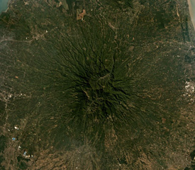 Muria forms the Muria Peninsula along the northern coast of central Java, further north of the main Sunda arc volcanoes in Java. Seen here in this June 2019 Planet Labs satellite image mosaic (N is at the top), the edifice is extensively eroded, and 12 maars have been identified around the main cone.
Satellite image courtesy of Planet Labs Inc., 2019 (https://www.planet.com/).
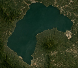 Gunung Seminung with a 500-m-wide summit crater forms the SE shoreline of Lake Ranau within the Ranau caldera, seen here in this September 2019 Planet Labs satellite image mosaic (N is at the top). An explosive eruption produced the Ranau Tuff out to 70 km from the vent. The N-S length of the lake is approximately 16.5 km.
Satellite image courtesy of Planet Labs Inc., 2019 (https://www.planet.com/).
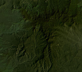 Crater Mountain is located in the Eastern Highlands Province of Papua New Guinea, seen here in this December 2019 Planet Labs satellite image mosaic (N is at the top). The field is an arcuate chain of eroded peaks containing two craters over 1 km wide and around 30 smaller identified vents.
Satellite image courtesy of Planet Labs Inc., 2019 (https://www.planet.com/).
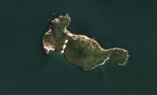 Moutohorā Island (Whale Island) is 11 km offshore from Whakatane in New Zealand, seen in this 21 November 2019 Sentinel-2 satellite image (N is at the top). The 2.5-km-long (E-W direction) island has three main features: East Dome, the Central Dome complex, and the northwestern Pa Hill.
Satellite image courtesy of Planet Labs Inc., 2019 (https://www.planet.com/).
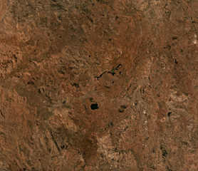 The Vakinankaratra volcanic field covers an area of 3,800 km2 in central Madagascar, some of which is shown in this September 2019 Planet Labs satellite image mosaic (N is at the top). The field contains monogenetic scoria cones, lava flows, lava domes, and maars.
Satellite image courtesy of Planet Labs Inc., 2019 (https://www.planet.com/).
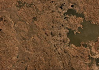 The Itasy Volcanic Field in central Madagascar covers an area of around 1,600 km2, some of which is seen here beside Lake Itasy in this September 2019 Planet Labs satellite image mosaic (N at the top). Several of the 131 identified scoria cones are in this area, as well as some lake-filled maar craters.
Satellite image courtesy of Planet Labs Inc., 2019 (https://www.planet.com/).
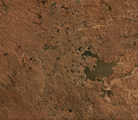 The Itasy Volcanic Field is a monogenetic field in central Madagascar around Lake Itasy near the center of this September 2019 Planet Labs satellite image mosaic (N at the top). The field contains scoria cones, lava domes, lava flows, and maars across an area of 1,600 km2. There have been 131 scoria cones identified throughout the field.
Satellite image courtesy of Planet Labs Inc., 2019 (https://www.planet.com/).
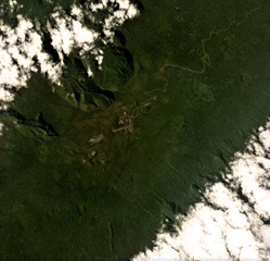 Santa Isabel (also called Pico Basile) is near the northern end of Bioko Island in Equatorial Guinea, seen here in this May 2019 Planet Labs satellite image mosaic (N at the top). Several eruptions occurred on the SE flank between 1989 and 1923. Several craters are visible across the summit area through the center of this image.
Satellite image courtesy of Planet Labs Inc., 2019 (https://www.planet.com/).
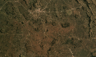 The Bufumbira volcanic field in SW Uganda contains numerous scoria cones including those shown in this August 2019 Planet Labs satellite mosaic (N at the top). The field is in the Virunga volcanic province in SW Uganda and covers approximately 320 km2 with Muhavura, Mgahinga, and Sabinyo along the southern boundary. Several of the scoria cones near the center of this image produced lava flows through the collapse of a flank, resulting in horseshoe-shaped edifices.
Satellite image courtesy of Planet Labs Inc., 2019 (https://www.planet.com/).
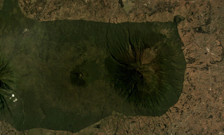 Muhavura is at the NE end of the Virunga volcanic range and is seen here in an August 2019 Planet Labs satellite image mosaic (N at the top). The summit is E of the image center, and W of that is the Gahinga flank cone. To the far W is the flank of Sabinyo.
Satellite image courtesy of Planet Labs Inc., 2019 (https://www.planet.com/).
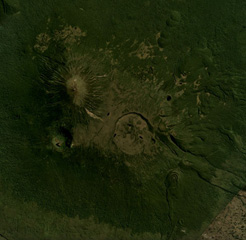 This June 2018 Planet Labs satellite image mosaic (N at the top) shows Karisimbi volcano of the Virunga volcanic field in Rwanda. The 1.5-km-wide Caldera Branca is seen near the center, with the summit to the NW and Mutango crater south of that. Extending SE of the caldera is a lava flow field with individual flows reaching 12 km in length.
Satellite image courtesy of Planet Labs Inc., 2018 (https://www.planet.com/).
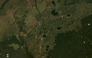 Lakes fill maars of the Bunyaruguru volcanic field, also known as the Kichwambe volcanic field, across this January 2019 Planet Labs satellite image mosaic (N at the top). The field contains over 130 craters and is located between Lake Albert and Lake Edward in Uganda.
Satellite image courtesy of Planet Labs Inc., 2019 (https://www.planet.com/).
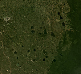 The lakes visible in this April 2019 Planet Labs satellite image mosaic (N at the top) formed within craters of the Kyatwa volcanic field between Lake Albert and Lake Edward in Uganda.
Satellite image courtesy of Planet Labs Inc., 2019 (https://www.planet.com/).
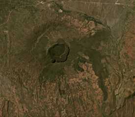 Suswa is the southernmost volcano of the Central Kenya Peralkaline Province (CKPP). The shield volcano has nested summit calderas that are visible in the center of this December 2019 Planet Labs satellite image mosaic (N at the top), with widths of 12 km for the largest caldera and 5.5 km for the inner caldera. More recent lava flows appear darker in this image.
Satellite image courtesy of Planet Labs Inc., 2019 (https://www.planet.com/).
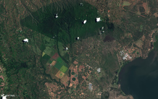 Ol Doinyo Eburru is across the center of this December 2020 Planet Labs satellite image monthly mosaic (N is at the top; this image is approximately 19 km across). It is composed of two eroded eastern (younger) and western (older) edifices, and the smaller vegetated Cedar Hill below the easternmost boundary with visible pressure ridges along the surface (lower right).
Satellite image courtesy of Planet Labs Inc., 2020 (https://www.planet.com/).
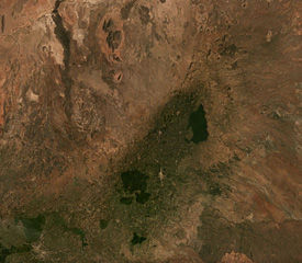 The broad NE-SW-trending Nyambeni Hills volcanic field is seen across this February 2019 Planet Labs satellite image mosaic (N is at the top; this image is approximately 80 km across). The field contains numerous scoria cones, craters, and lava flows across an area approximately 50 km in length, with the youngest features near the center.
Satellite image courtesy of Planet Labs Inc., 2019 (https://www.planet.com/).
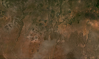 Cones, maars, lava flows, and craters of the Dilo-Dukana Field are visible in this December 2020 Planet Labs satellite image mosaic (N at the top; this image is approximately 104 km across) along the Ethiopia-Kenya border, which crosses roughly NW-SE through the view. The most prominent feature in the southern part of the field is the 1.8-km-wide Gof Dukana maar in Kenya, just SW of the center of the image.
Satellite image courtesy of Planet Labs Inc., 2020 (https://www.planet.com/).
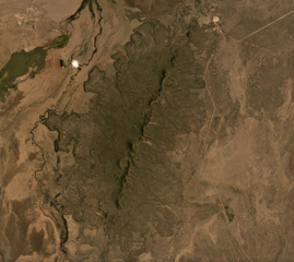 The Korath Range is the northernmost volcano of the Turkana rift in southern Ethiopia/northern Kenya. The central lineament of cones and craters has produced lava flows out to around 6 km from the vents. This September 2019 Planet Labs satellite image monthly mosaic shows the lobate flow margins and lateral flow levees and margins (N is at the top; this image is approximately 20 km across).
Satellite image courtesy of Planet Labs Inc., 2019 (https://www.planet.com/).
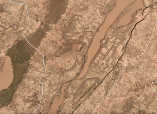 A large unnamed area of recent mafic lava flows is located on the floor of the Ethiopian Rift Valley SW of Tullu Moje volcano. The lava flows were emplaced within a NE-SW-trending zone near the active eastern margin of the rift valley, NE of Ziway Lake (W of this December 2020 PlanetLabs satellite image monthly mosaic, N is at the top). This image is approximately 29 km across.
Satellite image courtesy of Planet Labs Inc., 2019 (https://www.planet.com/).
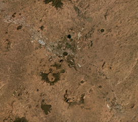 Bishoftu Volcanic Field is a monogenetic volcanic field containing tuff rings, scoria cones, lava flows, domes, and maars within the Ethiopian Rift Valley SE of Addis Ababa, seen here in a December 2019 Planet Labs satellite image monthly mosaic (N is at the top; this image is approximately 40 km across). The town of Bishoftu has developed within the field. Lakes such as Bishoftu, Hora, Kiroftu, and Bishofta Guda have formed within maar craters.
Satellite image courtesy of Planet Labs Inc., 2019 (https://www.planet.com/).
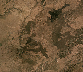 The Gudda and Bericha edifices comprise the Boset volcanic complex, one of the largest volcanoes within the northern Main Ethiopia Rift at 17 x 20 km in extent. The main edifices are in the lower left quarter of this November 2019 Planet Labs satellite image monthly mosaic with darker, younger lava flows on the flanks and to the NE at Kone (N is at the top; this image is approximately 39 km across). The Boset-Gudda) cone forms the SW potion, and the Boset-Bericha cone is NE.
Satellite image courtesy of Planet Labs Inc., 2019 (https://www.planet.com/).
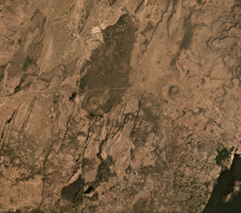 Beru comprises an area of Holocene basaltic scoria cones and lava flows located along the Main Ethiopian Rift between Fentale volcano to the upper right and Kone to the lower left. Several scoria cones are visible in this November 2019 Planet Labs Satellite image Monthly Mosaic (N is at the top; this image is approximately 21 km across). The lake to the lower right is Basaka, whose northern shoreline was formed by a young lava flow from a Fentale flank vent.
Satellite image courtesy of Planet Labs Inc., 2019 (https://www.planet.com/).
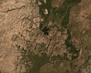 Lava flows form the southern flank of the Dofan volcanic massif, NW of a bend in the Hauash River, in the center of this December 2019 Planet Labs satellite image monthly mosaic (N is at the top, this image is approximately 20 km across). An undated darker lava flow above the center of this image erupted from a vent on the N flank.
Satellite image courtesy of Planet Labs Inc., 2019 (https://www.planet.com/).
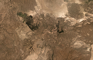 Gabillema is situated within the Addado graben and is seen in the center of this November 2019 Planet Labs satellite image monthly mosaic (N is at the top). Lava domes have formed on the flanks and a 5 x 17 km lava field covers the Ado Bad (Ado Lake) Plain, originating from a broad area of vents and cones on the northern side. The crater SW of the summit area is approximately 650 m wide; this image is approximately 52 km across.
Satellite image courtesy of Planet Labs Inc., 2019 (https://www.planet.com/).
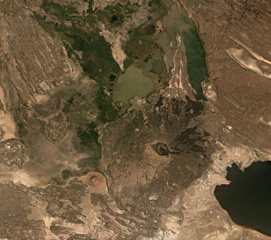 Dama Ali is located along the NW shore of Lake Abhe (right) at the southern end of the Kalo Plain, seen in this November 2019 Planet Labs satellite image monthly mosaic (N is at the top). Nested craters are at the summit, with the outermost visible crater reaching around 2 km across. Lava domes have formed along the flanks and the smaller Asmara cone is at the base of the SW flank with a summit crater approximately 800 m in diameter. Darker, more recent lava flows are also visible down the flanks.
Satellite image courtesy of Planet Labs Inc., 2019 (https://www.planet.com/).
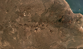 The chain of scoria cones and lava flows extending along an E-W trend in this December 2019 Planet Labs satellite image mosaic is the Assab volcanic field near the Red Sea coast in southern Eritrea (N is at the top; this image is approximately 58 km across). This field covers an area roughly 55 x 90 km, with lava flows reaching the Red Sea to the E, including to the coastal city of Assab.
Satellite image courtesy of Planet Labs Inc., 2019 (https://www.planet.com/).
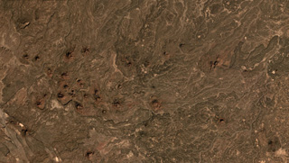 The Gufa volcanic field NE of Mousa Alli volcano extends from the Djibouti border (bottom left) into Eritrea, seen here in this December 2019 Planet Labs satellite image mosaic (N is at the top; this image is approximately 23 km across). Many scoria cones and lava flows are visible withing the broad field aligned in an E-W direction.
Satellite image courtesy of Planet Labs Inc., 2019 (https://www.planet.com/).
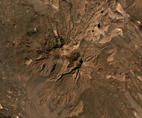 Mousa Alli is located on the border of Ethiopia, Eritrea, and Djibouti, and is seen here in this December 2019 Planet Labs satellite image mosaic (N is at the top; this image is approximately 21 km across). The main edifice in the center has undergone extensive erosion and there are scoria cones and lava flows on the SE and NW flanks.
Satellite image courtesy of Planet Labs Inc., 2019 (https://www.planet.com/).
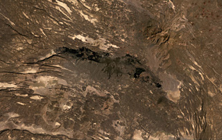 The roughly 40-km-long darker lava flows extending across the center of this December 2020 Planet Labs satellite image monthly mosaic (with N at the top) were produced by the western Manda portion of the Manda-Inakir complex and fill a graben formed through faulting. This complex represents a failed rift segment along the Ethiopia-Djibouti border. Mousa Alli is the edifice to the NE; this image is approximately 80 km across.
Satellite image courtesy of Planet Labs Inc., 2020 (https://www.planet.com/).
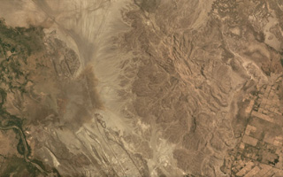 The Borawli lava dome complex is near the center (right) of this May 2019 Planet Labs satellite image mosaic (N is at the top; this image is approximately 12 km across). The eroded edifice is located in the southern Kali Plain of Ethiopia, around 200 km S of Erta Ale, and contains obsidian flows.
Satellite image courtesy of Planet Labs Inc., 2019 (https://www.planet.com/).
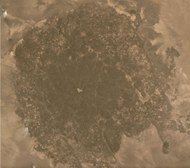 The Kurub edifice covers much of this May 2019 Planet Labs satellite image mosaic (N is at the top), with the darker area approximately 9 km in diameter. This broad area is composed of lava flows and vents, with sand filling the central crater. It is located south of Erta Ale, within the Saha Plain of Ethiopia.
Satellite image courtesy of Planet Labs Inc., 2019 (https://www.planet.com/).
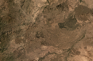 The Dabbayra shield volcano is shown in this December 2019 Planet Labs satellite image monthly mosaic (N is at the top; this image is approximately 58 km across). The complex has erupted along a NNE–SSW trend and covers an area of 30 x 60 km. The field largely comprises lava domes, scoria cones, and lava flows.
Satellite image courtesy of Planet Labs Inc., 2019 (https://www.planet.com/).
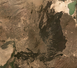 The Alayta shield volcano is in the center of this December 2019 Planet Labs satellite image mosaic (N is at the top; this image is approximately 82 km across), with a series of vents along the axis and darker lava flow fields surround much of the edifice. The flows reach Afderà to the NE. Lake Afrera is in the NE corner of the image.
Satellite image courtesy of Planet Labs Inc., 2019 (https://www.planet.com/).
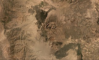 Ma’alalta, located along the western edge of the Afar Depression, has nested calderas that are seen in this December 2019 Planet Labs satellite mosaic (N is at the top), with ignimbrite deposits beyond the flanks. The larger caldera in the center of this image is about 7.5 km wide in the E-W direction. Darker basalt lava flow fields are visible, as well as thicker rhyolite lava flows and coulees to the south.
Satellite image courtesy of Planet Labs Inc., 2019 (https://www.planet.com/).
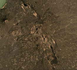 The Tat Ali volcanic complex is located within the NNW-SSE graben visible across this December 2019 Planet Labs satellite image mosaic (N is at the top) with Lake Afrera in the upper left corner. Lava flows have filled the graben, and lavas with flow ridges and levees can be seen near the center of this image. Borawli is the cone to the W, with a roughly 800-m-wide summit crater.
Satellite image courtesy of Planet Labs Inc., 2019 (https://www.planet.com/).
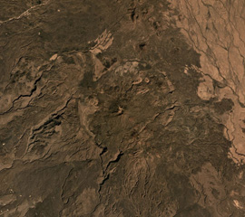 Asavyo (also called Bara’Ale) is at the southern end of the Nabro Volcanic Range between the Danakil Depression and the Red Sea, and is seen in the center of this 2019 Planet Labs satellite image mosaic (N at the top). The 6 x 7.5 km caldera rim is visible here, with a cone in the center that produced lava flows that have infilled the depression.
Satellite image courtesy of Planet Labs Inc., 2019 (https://www.planet.com/).
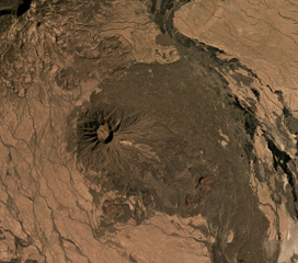 Sork Ale is part of the Nabro Volcanic Range between the Danakil Depression and the Red Sea. The 1,100 x 1,200 m, 300-m-deep crater is near the center of this December 2019 Planet Labs satellite image mosaic (N is at the top). Darker eroded lava flows form the flanks and the lighter areas to the NE and SW are ignimbrite deposits from large explosive eruptions.
Satellite image courtesy of Planet Labs Inc., 2019 (https://www.planet.com/).
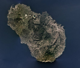 Pantelleria is a volcanic island 95 km west of Sicily and is composed of scoria cones, lava domes, lava flows, explosive eruption deposits, and calderas, with the Cinque Denti caldera rim visible in the right side of this 2019 satellite image (N is to the top). The 330 x 360 m crater near the center is within the summit of Monte Gibele, and lava flows with visible flow levees form the flanks. Montagne Grande is to the west (left) of the crater.
Satellite image courtesy of Planet Labs Inc., 2019 (https://www.planet.com/).